
Trip to Croatia, Greece, Turkey - September 2009
The objective in this trip was a holiday but also attending two aviation meetings; a Greek/Turkish Fly-In at Canakkale (LTBH) in Turkey, and a meeting at Prague (LKPR) in the Czech Republic. The two events had a 2-week gap between them and as Canakkale is very close to Greece we decided to spend the intervening period in Greece, in the Eastern Aegean.
The Prague section of this trip was not flown, due to poor weather.
We had already visited a number of Greek islands (Corfu, Crete, Santorini, Mikonos, Paros) in previous years so this time we chose Lesbos, which was also conveniently enroute from Canakkale to the next planned stop at Split, Croatia. The airport there, Mitilini LGMT, does not have Avgas but has Customs and is close enough to other airports with Avgas.
Being IFR, the format of the trip is very similar to other IFR trips I have done e.g. Prague. Other VFR and IFR trip reports can be found here. With the exception of weather strategies, IFR (known in the UK as "airways") flying follows a standard pattern but there is often a suprise due to weather or ground based factors.
Here is a glossary for non-aviation readers.
Aircraft
The aircraft is a 2002 Socata TB20GT which has a zero-fuel "book" range of approximately 1100nm and a cruise speed of 155kt TAS at 10,000ft. Extra economical cruise power settings can extend the range to 1300nm. It has a ceiling of about 20,000ft and is equipped with oxygen. This particular aircraft is not certified for flight into icing conditions but has a TKS de-iced propeller.
Navigation equipment includes a KLN94 IFR/BRNAV GPS and a KMD550 MFD and these are used for primary navigation. The aircraft has a KFC225 autopilot which can track VOR/GPS/LOC/ILS and fly a preset altitude or VS. There is an additional battery powered Garmin 496 GPS which also provides an audio terrain warning (TAWS) function with a European terrain and obstacle database. Some notes on the TB20 aircraft are here.
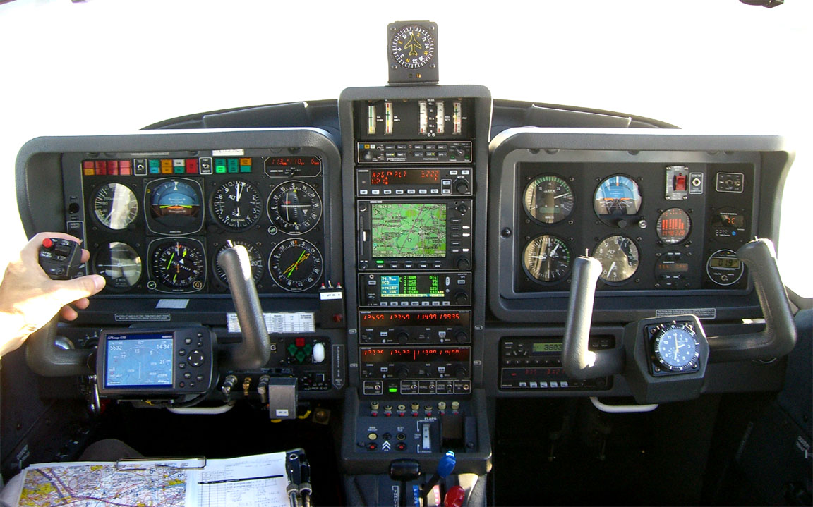
The equipment consists of good reliable late-1990s-era avionics which is perfectly fine for the task of European IFR flight. I have resisted doing the huge expensive avionics refit which many pilots have done because it would not provide any additional mission capability. The only thing which I sometimes miss is a GPS which contains the full "RNAV" SID/STAR depictions - mine has the non-RNAV ones only - but even this would be a major job.
The aircraft is US registered and the pilot (myself) holds an FAA CPL/IR.
Route Planning, Weather Sources, etc.
For additional information on engine management for long flights, please refer to Granada writeup which used very similar techniques. This article deals with IFR flying around Europe in general.
There has been a new development on the Eurocontrol route development front, however.
For some time, I have been using Flight Plan Pro to develop these routings
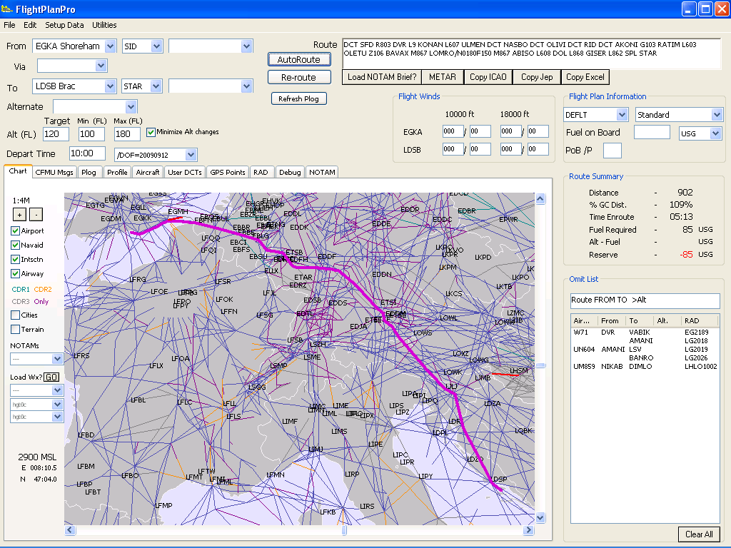
This is a great tool which is getting better all the time, but very occassionally it fails. For example, on the routing to Turkey, it sometimes failed because it could not interpret an obscure Eurocontrol error message saying one cannot route between Turkey and Greece other than via specific intersections. Since Eurocontrol do not disclose the full range of these messages, dealing with the weird special cases like this is never going to be easy...
Fortunately, a new facility has appeared from Avbrief which connects to a new Eurocontrol route validation function which can also "suggest" routings
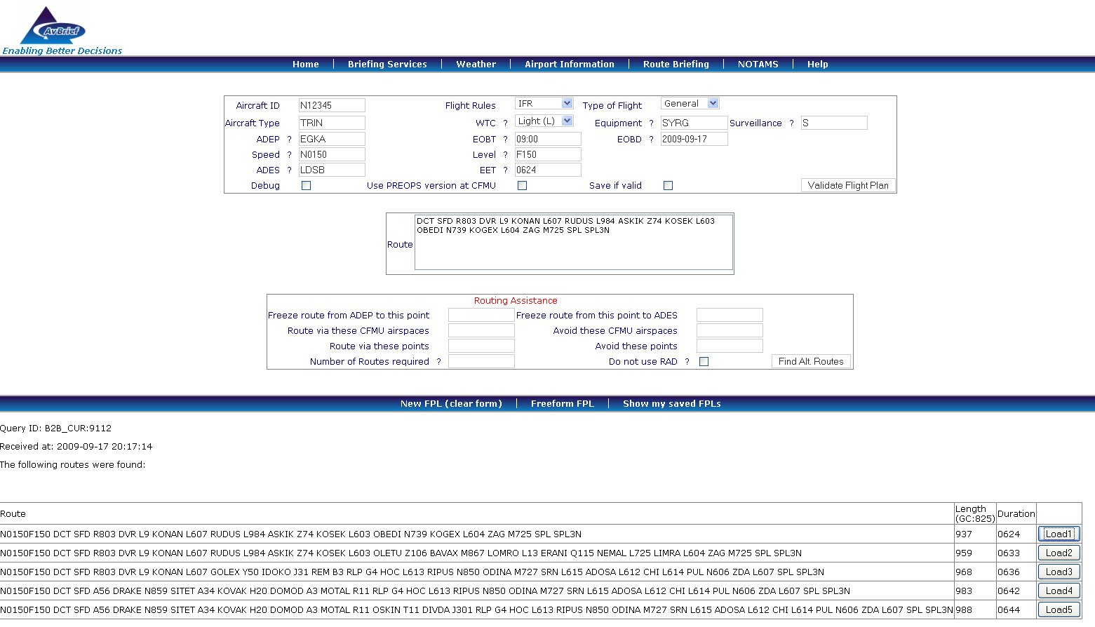
Currently, these suggested routings are less efficient than they might be, for two reasons: they are developed wholly at a single flight level, and they do not use DCTs. This results in a larger distance overhead (over the Great Circle distance) than routes from Flight Plan Pro, but the suggestions always 100% validate because they come from the same "permitted routings" database which Eurocontrol use to validate user-submitted routes. This facility requires an Avbrief membership which is very reasonably priced.
Flight Plan Pro remains the best current tool for the rapid development of Eurocontrol acceptable routings.
The Plan
The entire trip as originally planned was:
Departure Shoreham EGKA
Brac (Croatia) LDSB
Canakkale (Turkey) LTBH
Lesbos (Greece) LGMT
Thessaloniki (Greece) LGTS - fuel stop only; may not be necessary
Split (Croatia) LDSP
Prague (Czech Rep) LKPR
Return to Shoreham EGKA
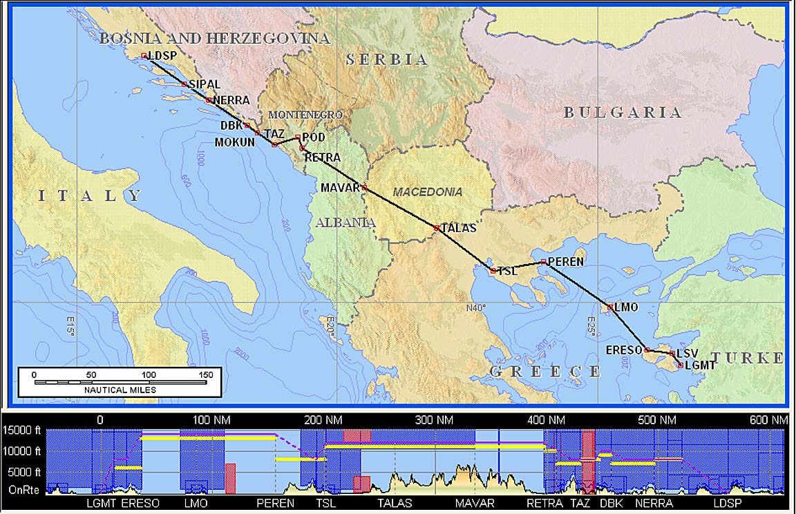
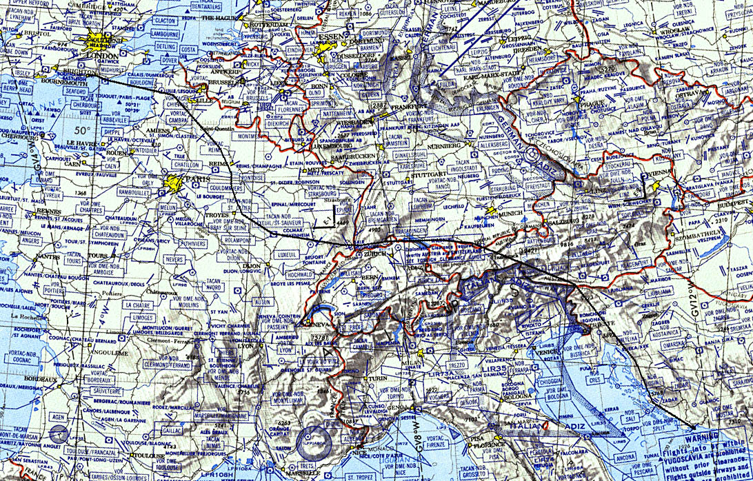
The actual Eurocontrol-validated airways routes are shown in the following pic
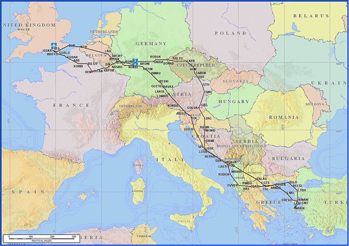
All routes were developed using Flight Plan Pro, transferred into Jeppesen FliteStar for routepack generation, and printed out as 1"=10nm strip charts, together with all approach plates from Jeppesen JeppView 3, including various alternates

I have found that printing at 1"=15nm reduces the amount of paper but some airway intersection names are missing.
It is always much easier to print everything which might conceivably be required while still at home. Even filing the first few flight plans, if this appears sensible given the weather, is worth doing, because getting a flight plan changed can be done with just a phone call (or a radio call to the Tower) whereas filing a whole new one takes a lot more effort.
Getting PPR
PPR (Prior Permission Required) is required at many airports in Europe, and the problem is getting worse. Many other airports are "PNR" (Prior Notification Required) but this is de facto identical to "PPR" because you need to be sure they received the notification so you have to contact them anyway. In some countries - particularly some southern European ones like Spain, Italy or Greece - ATC will simply refuse a landing clearance if this stupid process has not been complied with, or it has been complied with but they lost the paperwork, or you got the permission verbally from someone who is out to lunch, and forcing you to fly to the alternate airport.
So PPR needs to be taken seriously and if the airport cannot be positively contacted, one should not fly there. Even in the UK, I would not generally fly to an airport where the telephone is not answered because it may be closed.
I have had some serious problems with PPR in the past, so this time I decided to deal with it in an absolute manner: no positive confirmation received = no flight to that airport.
If flying a non-EU registered aircraft (mine is US registered) there are some cases where PPR is needed for these when it would not be needed otherwise, so the pilot needs to explicitly state the aircraft registration (and put UNITED STATES REGISTERED in case the officer is a bit dim) to make sure this sinks in.
Actually getting the PPR confirmation remains a tricky process when outside the UK; specifically when flying in countries where the quality of their published aeronautical information is not that great. The foremost problem is that many published contact numbers are either duff, or lead to the wrong office.
If one can speak the local language then telephoning the airport - initially on any working number - is likely to be the best way. If one cannot, one often finds that the published numbers for many airports - especially the bigger ones - lead to the passenger flight enquiry desk or to somebody's office where nobody can (or will) speak English.
Therefore, for trips which can be - at least roughly - planned some days or weeks ahead, it is easier to shoot off faxes to them all (example) and see what comes back. I get about 50% success with faxes, assuming that I send several, 1 day apart.
As of recently, the AFPEx AFTN messaging facility (writeup) enables the same job to be done using AFTN messages; these are guaranteed to be read by somebody with at least a rudimentary command of English because the AFTN is vital to the functioning of any airport. Whether the receiver will pass the message to the person dealing with PPR is another matter... I am getting some success with this method, again assuming I repeat the request several times and include a fax number in the message. Why the success rate is poor is an interesting question... presumably it is mostly due to administrative incompetence, or arrogance.
However it turns out that many airports around Europe do not have an AFTN terminal and AFTN messages addressed to them in the traditional manner (e.g. xxxxZTZX or xxxxZPZX where xxxx is the ICAO airport code e.g. LDSB for Brac) get diverted to a nearby big airport which prints them out and faxes them over. Understandably, the airport you are trying to contact is not keen to reply via the AFTN, but can fax you back directly.
Other methods of establishing contact are: contact the local aeroclub (if there is one); get a locally based pilot friend to sort it out for you (an excellent method); get the airport office at the airport of departure to call them for you (not great if the destination turns out to be say 24hrs PPR; find the number for a nearby large airport as their ATC is likely to have the numbers for airports in their proximity.
I am advised by other pilots that one is more likely to get a response to a fax if it is written in the local language. This is not suprising...
Finally, one can use an airport directory such as ACUKWIK to locate phone numbers, but - for Europe - this grand publication is packed with duff data too. It works better for handling agent numbers and these would normally organise PPR as a part of the service. In Greece, this doesn't quite work and Olympic Handling doesn't seem to want to get involved with anything beyond driving buses. Handling can be expensive but if handling is mandatory (which is the case at many larger airports) you have no choice anyway. The top end of GA (turboprops and upwards) tends to use handling agents whenever possible and one can see why. Some notes on this stuff can be found here.
The first stop - Brac LDSB - airport was extremely easy to communicate with by both email and fax. However, they close at 1400Z so there was a possibility of not making it there. The airport offers a late closing facility for Euro 60/hour which is very reasonable (Shoreham is around 10x more) but needs to be requested the previous day, which I did. It doesn't cost anything if it is not used. I did discover that Brac does not have its own AFTN terminal; free text messages sent using the AFPEx tool to LDSBZTZX or LDSBZPZX end up at Split who then fax them over.
Canakkale LTBH replied to my AFTN messages but their reply contained just the handling agent contact numbers. The Turkish pilot group who organised the fly-in had already sorted out the permissions but I contacted the airport anyway because my aircraft was US registered and these (or any non-EU registrations) are occassionally treated "differently". Turkey was known to impose a 24hr PPR on all US registered aircraft in past years. Fortunately I was able to get a Turkish pilot friend to sort out the landing permission number. With Turkey (or Greece for that matter) one cannot take chances with this stuff.
Lesbos LGMT never replied to multiple faxes or multiple AFTN messages. Eventually I phoned them but found that most of the numbers I had (from Navbox, Flitestar, or the ACUKWIK airport directory) were duff; for example the number for OPS was somebody's house. But one of them (the met office) worked and I tracked down the others from there. Three people had to be phoned: one man for the landing/parking PPR (0030 22510 38726); another at Olympic Handling (0030 22510 61802); a 3rd re the Customs PPR (0030 22510 38703). There are some differences among Greek pilots as to whether LGMT needs PPR at all but the US aircraft registration in my case has complicated things in Greece in the past. The people I got through to certainly made it clear that permissions were necessary (but they would say that anyway...).
Thessaloniki LGTS replied to a fax, with a standard letter saying no PPR is required, giving the numbers of three handling agents; one of them was Olympic (0030 2310 985237) which is the standard option in Greece. If parking for more than 2 hours one needs to obtain a ..... "long term parking permission" but we would be just refuelling anyway. There was no reply on the aforementioned number so AFTN messages were sent to find out, and these elicited the response. Previous faxes were ignored. Note 5/2010: no avgas at LGTS.
Split LDSP airport never replied to faxes or AFTN messages but after a few abortive attempts I got through on the phone 00385 21 203 353. Landing and handling was Euro 35 and parking Euro 8/day; all very reasonable. No PPR is involved as (September) there is not so much traffic but they would like a fax (00385 21 203 413) before the flight.
Prague LKPR doesn't need PPR.
Outside of Europe, many countries require permits for both overflight and landing. These permits are usually complicated to arrange, and most pilots flying far out use one of the specialised overflight permit agents listed on my aviation home page. In this case, Turkey is known for some level of PPR for N-reg aircraft but the excellent organisers of the Turkish Fly-In sorted it all out.
The Flight
Shoreham (EGKA) to Brac (LDSB)
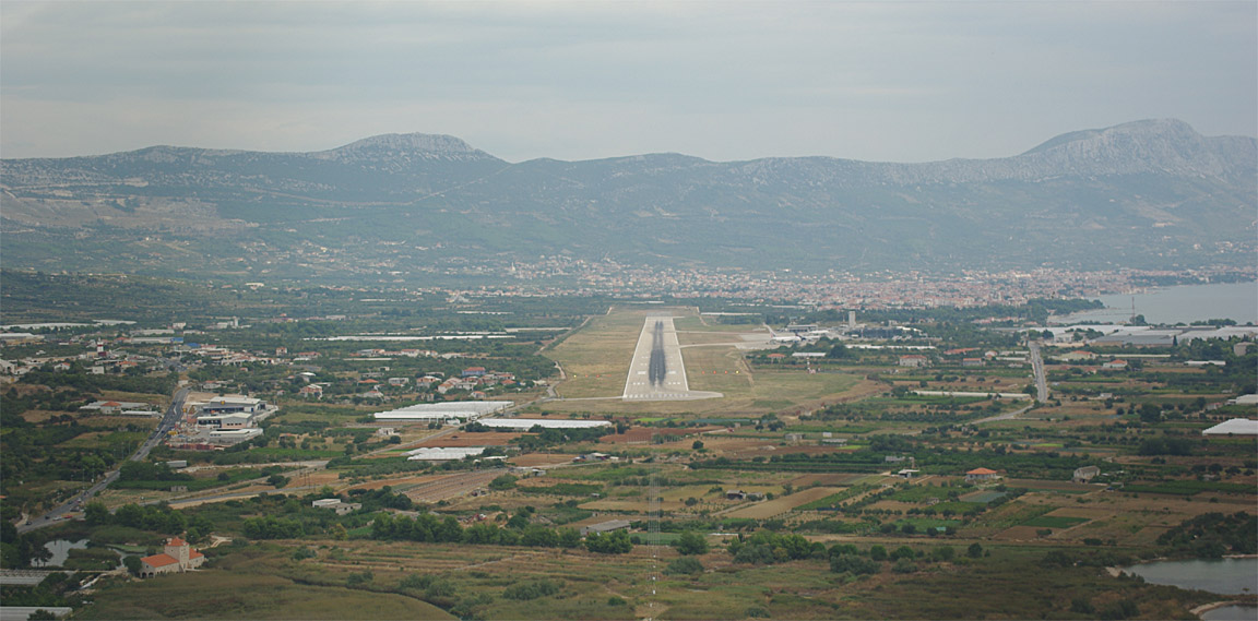
Croatia is an "aviation heaven", with easily GA-accessible airports all the way down its long coast. These start with Pula and continue through Losinj, Brac, Split, and Dubrovnik - all with Avgas and Customs. The tiny place of Losinj in particular shows a can-do attitude where the presence of one policeman makes it an "international" airport. These airports are all located along the route to the Aegean and while some of them close relatively early, only Split requires PPR and even that only during the peak season (August and before). The ATC is also superb and I cannot see there would be any problems with diversions. These factors make the "Croatian coast" a perfect route to the Aegean because after the last outpost of "civilised aviation" (Dubrovnik) everything gets a lot more complicated. Tirana LATI has no avgas and requires 14 days' PPR (I've been there!), and there is nothing until Corfu LGKR which has customs and avgas but requires 24hrs' PPR which is occassionally refused for seemingly arbitrary reasons. For an aircraft equipped with an accurate fuel metering system, linked to the GPS for a continual computation of Landing FOB (fuel on board), flying along Croatia is a good strategy - if the FOB figure falls below a set reserve (e.g. due to an unexpected headwind) one would simply drop into any of the Croation airports for fuel and maybe a short stay; the people are very friendly and the food is excellent. One may ask "why not Italy"... one answer is the "Italian experience" described in this trip report, but Italy really does have poor GA services.
Brac was chosen as the fuel stop enroute to Turkey because, at 900nm, it represents the furthest point from the UK which I am happy to fly direct, and its opening hours (at this time of year, weekday, closing 1400Z) fitted well with the earliest possible departure from the UK. It has a NDB approach but nearby Split has an ILS which provides a good alternate.
Due to the requirement to be at Canakkale, Turkey LTBH on a Friday morning for a GA fly-in event, but with Canakkale closing too early to make a one-day journey from Shoreham (with the necessary 1 fuel stop) possible, it was necessary to fly to Brac on Thursday, or possibly earlier. I thus set aside two days to depart from the UK: Wednesday or Thursday.
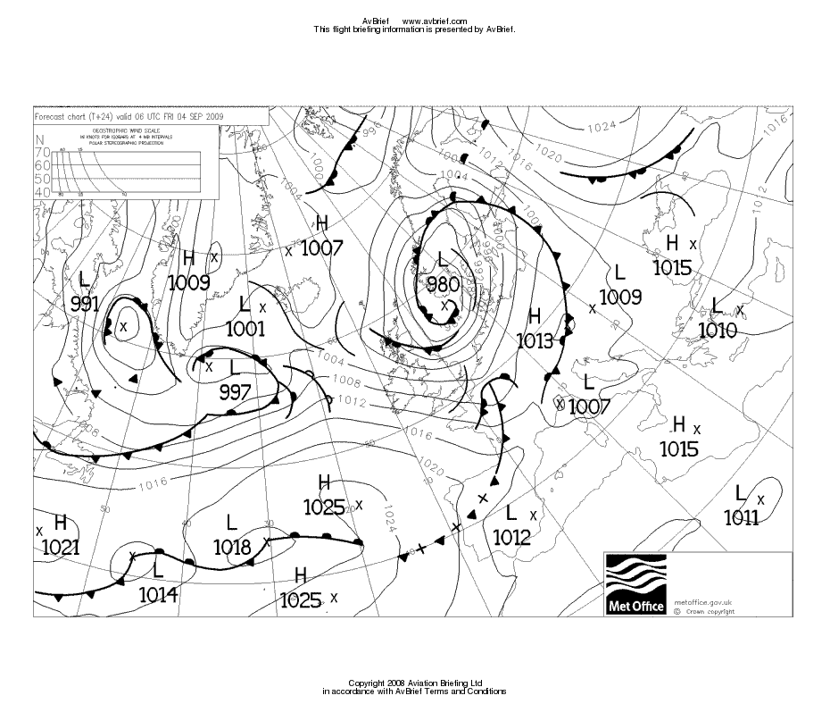
Usually the biggest challenge on a trip from the UK to the southern parts of Europe is getting out of the UK, and crossing the Alps. The UK suffers from poor weather comprising of a sequence of fronts moving west to east. This process is occassionally interrupted by the formation of a high pressure which keeps the muck away from the southern part of the country - which is why property prices are so much higher down there!
Over the few days preceeding the departure date, the MSLP (mean sea level pressure) charts were examined daily to see which of the two days would be suitable. Unfortunately, none of the possible days offered obvious clear conditions. In the following images, the approximate route is shown as a green line, and particularly objectionable chart features are marked in yellow.
Wed Thurs
- Wed is the better of these two
Wed Thurs
- These are similar but Thurs has stronger winds which are conducive to icing
conditions on the N side of the Alps
Wed Thurs
- Wed is the better of these two
Eventually the decision was narrowed down to "probably Wednesday" using these two
On the day before departure, a professional forecaster was contacted for a view on which is better and he concurred with me that Wednesday is the better day, with IMC probably below FL170 and he suggested that the front near the Alps is likely to be a weak one. I don't normally fly through fronts so this was very relevant.
On the evening before departure, the 0600 and 1200 charts showed that provided one got away early, it should be OK. The 0600 and 1200 SigWx charts did not show anything suprising - these however need to be treated carefully as they only show weather that is hazardous to large de-iced aircraft.
I normally cancel any flight on which IMC is very likely to be found enroute above the aircraft operating ceiling of 20,000ft. Some methods for determining the cloud tops are here. The forecaster, and Meteoblue together with some ascent data taken at 0000Z before the departure day more or less confirmed that this would be OK. Hazardous conditions at the departure and arrival areas are another issue but in this case Brac was having excellent weather, and the departure end could be verified by looking upwards...
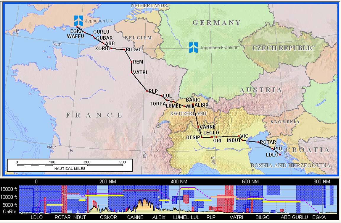
The route was
FL120
EGKA
DCT SFD R803 DVR L9 KONAN L607 ULMEN DCT NASBO DCT OLIVI DCT RID DCT AKONI G103
RATIM L603 OLETU Z106 BAVAX M867 LOMRO/N0150F150 M867 ABISO L608 DOL L868 GISER
L862 SPL
LDSB
Alternates: Losinj LDLO, Split LDSP, Dubrovnik LDDU
900nm (airways); 825nm (GC)
Note: the Eurocontrol routings given here and elsewhere will most likely not work by the time you might try them because the precise form needed to get the route into the computer changes from one week to the next, and there are frequent differences between weekdays and weekends which are largely due to a lack of military activity on weekends.
Beware: the terrain profile shown in the route illustrations (e.g. the one above) is not accurate. The Jeppesen Flitestar software contains large elevation errors. Also, the flight level shown in the profile diagram does not relate to the flight; filed or actual.
This was to be one of the longest flights I had ever done. However, the pressure charts clearly showed a substantial tailwind for the first 1/3 of the route, and little significant wind for the rest. Optimally managed (climbing using the constant-EGT method all the way to the cruise level, and cruising at LOP at FL080 or above) the TB20 will do 1300nm to zero fuel, in zero wind, so the margins were substantial. Factors which can reduce the range are: headwind; detours around bad weather; having to cruise above about FL170 due to weather (this requires max RPM and 100F ROP which uses about 10% more fuel per mile).
The flight plans for the first two legs EGKA-LDSB and LDSB-LTBH were filed using AFPEx the evening before the flight. The ACK messages each arrived within about 20 seconds.
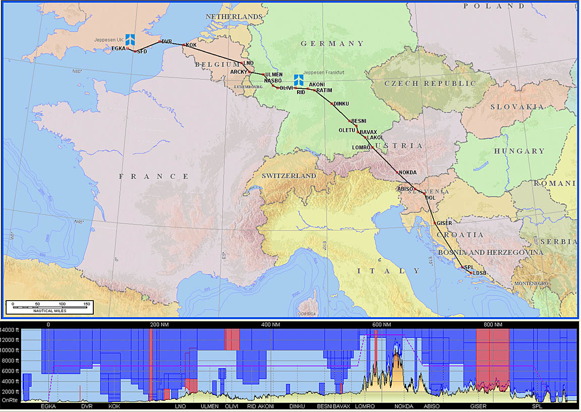
Unfortunately I did not manage to get away as early as would have been ideal, and the rain had already moved in. However, the TCUs were evidently well spread out, and the "organised IMC" between them was obviously quite thin.
The departure was filed for 0715Z which is the earliest possible at Shoreham (engine start at 0700Z). As often happens, Eurocontrol generated a slot - for 0740; this was discovered when still at home when I started up AFPEx on the morning of the flight. However these slots often shrink shortly before departure and one must be ready to depart at the original EOBT (estimated off block time). Sure enough, the Tower advised a new slot of 0745, another at 0740, and finally, at about 0715, another one arrived for 0725... This is a ridiculous process which bears no resemblance to real traffic/airspace bottlenecks and is probably caused by rules on how many airplanes an ATC desk is allowed to handle in its sector, regardless of their vertical separation. Because I used AFPEx rather than Homebriefing these slots could not be notified to me directly (SMS or email) and the Tower sent a fire crew vehicle to tell me of the last slot.
The whole trip was very nearly cancelled at that point. The starter motor was dead. I suspected a duff starter relay. The aircraft contains several heavy relays which are off the shelf 24V commercial vehicle parts, resold as usual without any modification at a 10x mark-up with "aviation approved" documents. They do fail sometimes; I have a few of them among a pile of spares at home but not this one. I nearly cancelled the flight plan but had a quick look somewhere first... and sure enough one of the main bus circuit breakers was open. It had obviously been kicked - something which is easy to do in the TB20 due to their position in the footwell.
The climb entered IMC within minutes
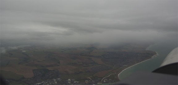
This was out-climbed rapidly
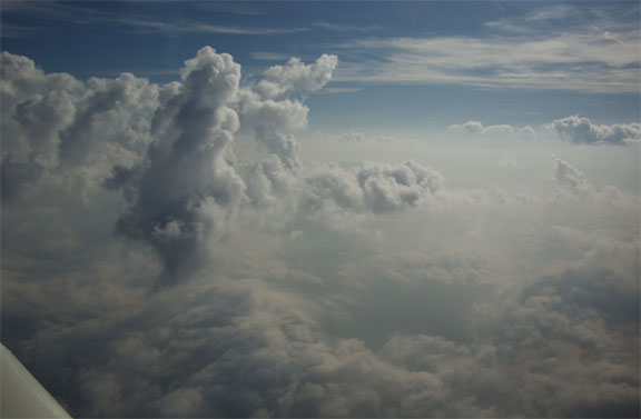
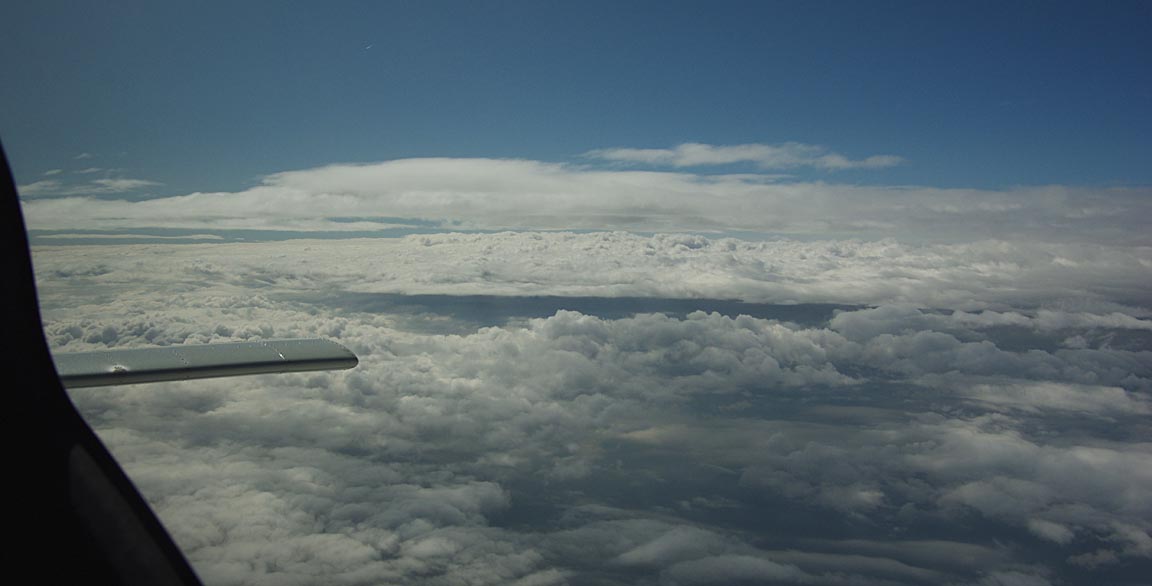
but, further along, the layer above thickened
and could not be outclimbed. It was thin and one could often see the ground. The sun was also clearly visible above. I climbed to a temperature at which supercooled water is unlikely to exist in stratus cloud (-15C) which was at FL190. The propeller TKS de-ice was ON but not the slightest trace of icing was ever observed (on the entire flight) on the wings or the elevator.
On all flights on this trip, the climb was done using the constant-EGT method: note the EGT of a particular cylinder shortly after takeoff, and then lean progressively to maintain that EGT figure as the climb proceeds. This enables a climb to be done all the way to the aircraft's operating ceiling, with optimal fuel efficiency. The constant EGT procedure also maintains a relatively constant (actually, gradually decreasing due to the decreasing power) CHT. This procedure requires adequate engine instrumentation.
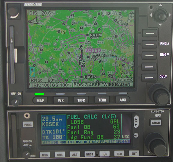
There was a substantial tailwind resulting in a ground speed of 180kt over Germany, and a computed Landing FOB (fuel on board) of 37 USG which, had the ground speed continued for the remainder of the route, would have taken us to somewhere past Crete...
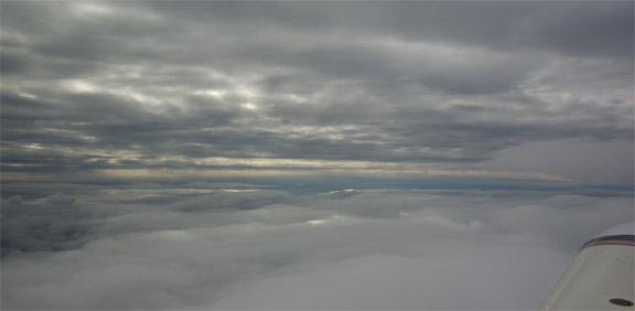
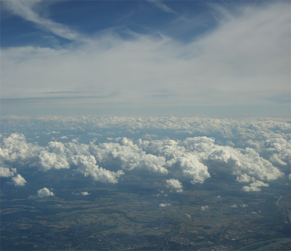
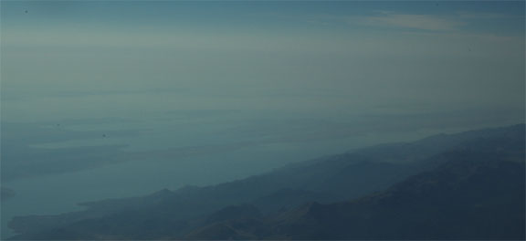
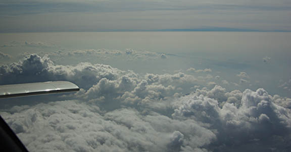
As predicted by the satellite image, a couple of hours later the haze ended
The "feared" front laying before the Alps turned out exactly as per the forecaster's view - tops at FL170 and not really significant
and it was crossed at FL180. I had descended from FL190 to FL180 earlier because one can fly LOP at FL180 whereas FL190 requires extra power (about 100F ROP) which uses about 10% more fuel.
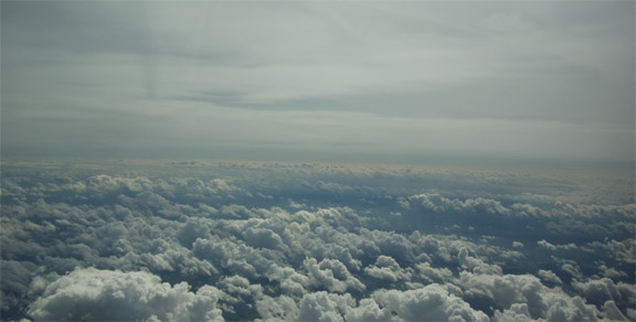
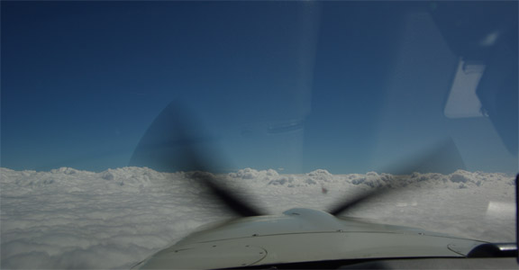
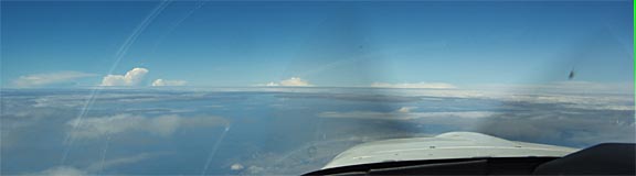
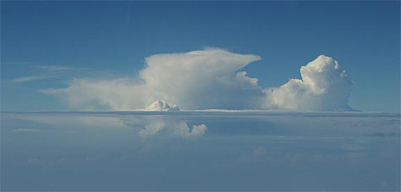
Some spectacular cloud formations were seen along the route
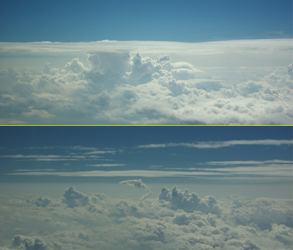
and the flight had to continue at FL180 for most of the way to destination, to remain above this stuff.
For fun, I have been experimenting with a simple USB webcam which takes 1 image per second. When these JPEG images are combined into a standard 25 frame/sec movie (using Adobe Premiere Elements) you get a ~ 3700kt movie such as this
which shows the departure and the first few hours of the flight at FL180-190, and due to its short duration is not too boring. A good movie player which is compatible with most formats is VLC. There is an undesirable propeller effect which could probably have been removed by using a slower shutter speed - probably achievable with a neutral density filter. However, a good quality video requires a high quality camera and a lot of attention to cockpit reflections. A side-looking camera is one easy way to get a good video because it avoids the windshield distortion and it is easy to avoid reflections. The ultimate is a forward-looking camera mounted outside the cockpit but this is complicated if done legally; it also needs to be watertight.
I don't think I have ever before had to fly as high for as long. The large carbon-kevlar composite oxygen cylinder really paid off since only about 1/3 of it got used up. I find a cannula is perfectly comfortable at FL180, delivering a 93% blood oxygen level with the relatively primitive Precise Flow mechanical demand regulator. The Mountain High O2D2 electronic demand regulator works better but when its battery runs out, it fails shut which may not be great at FL180 with another 5hrs to go at FL180. However, other pilots I know have problems at these levels and caution would therefore be recommended.
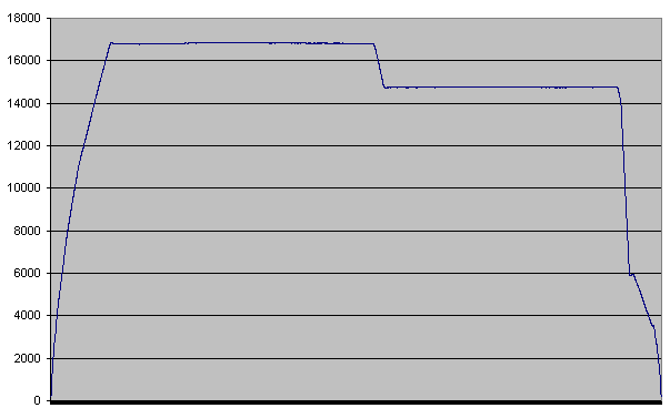
The vertical profile of this flight is here (track log; 405k)
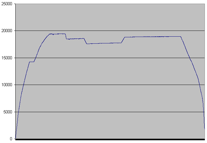
The two main apparently constant altitude portions have a very slight but visible slope. This is because when flying on a constant altimeter setting (1013mb) towards a high pressure area, one ends up climbing. In effect, the aircraft is flying a constant pressure surface. The temperature comes into it as well. However, the GPS which was used to capture the data merely records the actual altitude above sea level. Note: the altitude column in that track file is about 200ft too high, due to a well known firmware bug in the SIRF-1 chip used in the bluetooth GPS receiver which was used to get that track log.
At FL190, the operating parameters were: MP=14", 7.7GPH, 2575rpm. The TAS was about 130kt. Above about FL170 it is necessary to use higher RPM and to reach the FL200 ceiling the maximum RPM (2575) is necessary; this costs significant extra fuel.
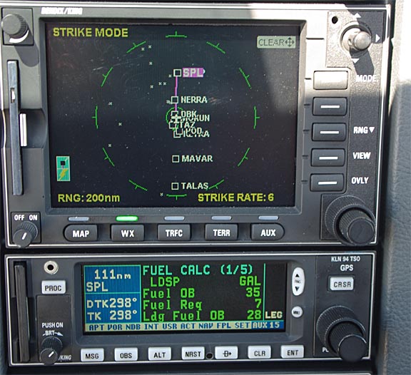
The tailwind almost disappeared around the Alps but no headwind was encountered. As the next pic taken 80nm before landing shows, the Landing FOB of 29 USG (reduced from the earlier 37 USG due to the now-lower ground speed) was still sufficient for another 3 hours' cruise i.e. 450nm - approximately Crete and certainly within reach of a good number of airports along Croatia and even Corfu, all with FAA legal IFR reserves and much more...

The TB20GT fuel gauges are accurate but obviously nowhere near as accurate as the totalising flowmeter used to compute the above FOB figures. For optimum fuel efficiency when flying alone (Justine joined me in Turkey 2 days later, due to prior engagements) I run the LH tank down by about 7-8mm on the gauges and this balances the aircraft so the ailerons are neutral. On long trips like this one, the LH tank approaches exhaustion but obviously one does not want an engine failure at an inopportune moment; actually I don't want one at any time! Some pilots do really run one tank empty (till they hear the engine sucking in fuel with air bubbles) and this has the benefit of yielding the maximum range because you know all usable fuel is in the second tank, but I run down the first tank only to the point at which the Low Fuel warning appears - this happens around 8 USG in that tank and corresponds to just below the 1/4 mark
The total flight time was pretty close to the worst-case original plan, and the final 80nm of the flight was done as a continuous descent from FL180, at 200-300fpm, at best power, to bring the computed landing time before the 1400Z airport closing time - to save the extra-time closing surcharge.
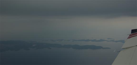
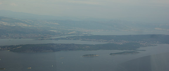
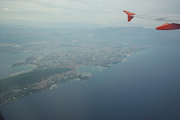
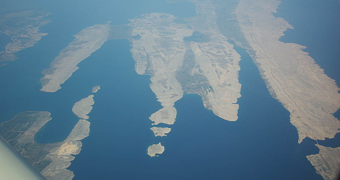
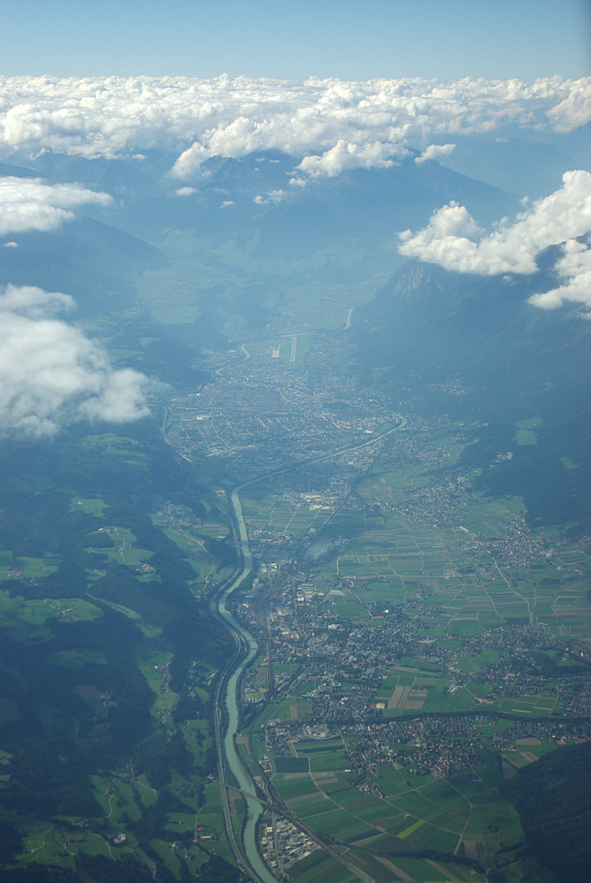
By around Pula, the cloud had cleared over the sea and the Croatian islands appeared in the haze
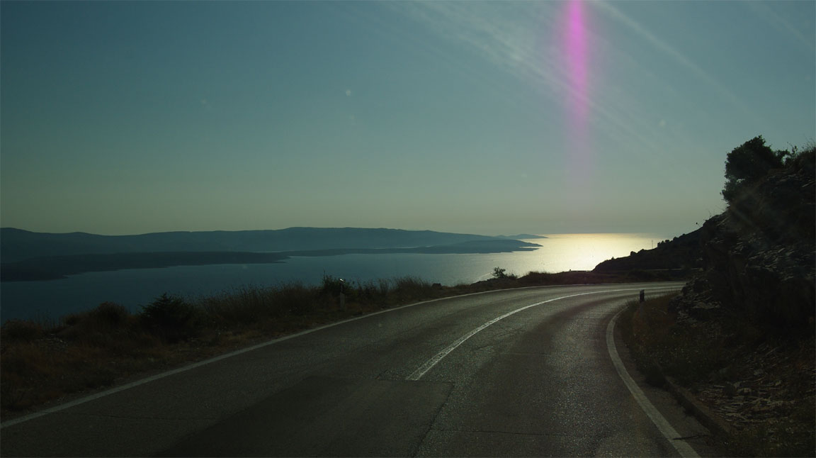
The approach was a visual approach but still under IFR, with a handover from Split Radar to Brac Tower when established on right base. This is the north coast of the island - apologies for the cockpit reflections - showing the town of Supetar
There was about 8kt of surface wind, aligned with the runway, which made for an easy landing
I landed at 1355Z which was 5 minutes before the airport closing time, so I avoided the Euro 61.50 (incl. VAT) charge for the extra opening time. Rather fortunate that this timing was achieved after such a long flight.
All ATC units along the route were really great. IFR flight in Europe is a point to point RNAV navigation exercise and a DCT to a waypoint which happens to be a VOR but is 200nm away is readily issued; one could not fly this way with a KNS80... an IFR GPS is the only way.
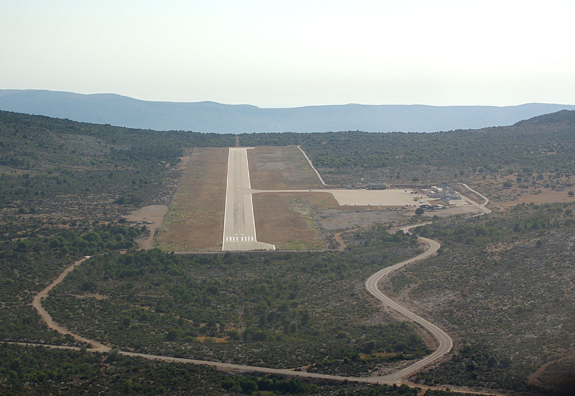
Brac is a totally modern and well organised airport which should be the envy of anywhere in the UK and probably anywhere else in Europe
The staff are very friendly and helpful, and communications are excellent, by both email and fax. Fuel was done immediately; the error between the computed FOB and the fuel pump readout was 0.36%, with the difference on the safe side, which is well within the error band of either the aircraft flowmeter or the airport pump. The aircraft was then parked in the corner of the huge apron
A DA40 departed as I landed but otherwise it was quiet. The flight control officer popped down to say Hello and said that the flight time of 6:20 was the longest that anybody had flown to Brac since it opened in 1993...
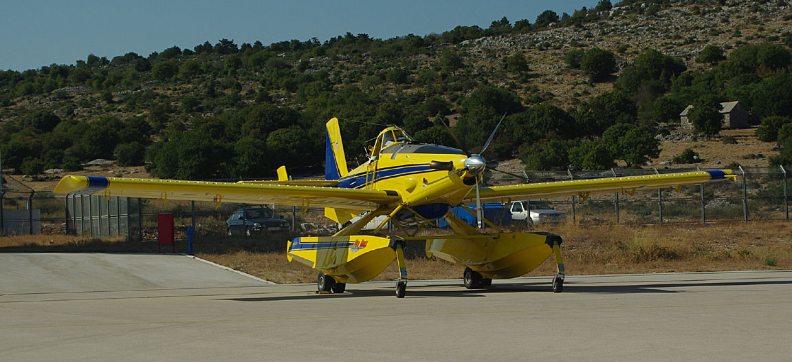
There was an unusual aircraft parked there - a turboprop seaplane which scoops up water and is used for fire fighting. It is apparently based on a crop spraying design
This flight could not have been done under conventional VFR (legally) due to cloudbases versus terrain. It could not have been done under VFR flown as "VMC on top" (legally) unless banking heavily on many controlled airspace clearances which I do not think would have been forthcoming at the required "VMC" level of around FL200+. It could not have been done (sensibly) under IFR in a non-deiced aircraft with an operating ceiling below FL180 as several hours would have been spent in potentially icing conditions, and collecting a lot of ice in the stuff I saw below me would have been assured over that length of time. Of course, it could not have been done without oxygen.
The airport has its own taxi. There are no buses. I stayed at the nearest town - Bol. I have been to Brac before so here are just a few pictures. The first one shows the nearby island of Hvar - highly recommended for a visit which is a quick boat ride
I stayed at the excellent Hotel Kastil which is right on the waterfront in the marina.
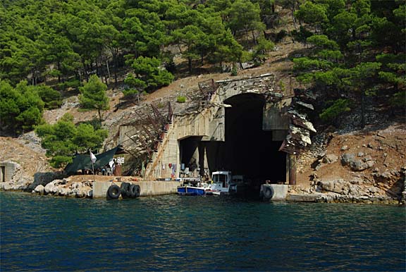
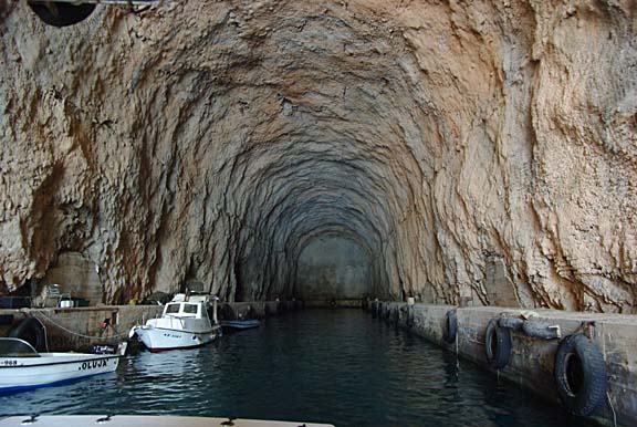
There are some intriguing submarine pens down the coast from Bol which according to locals date back to WW2 but may have been built during Tito's Yugoslavia
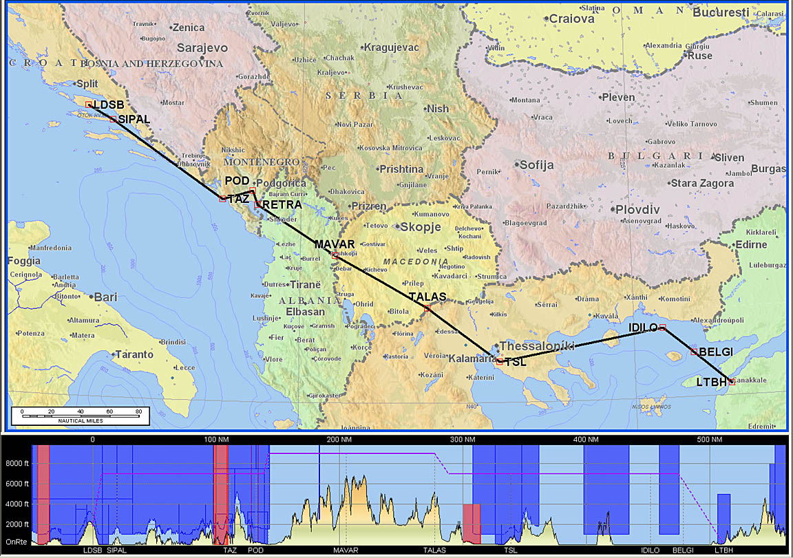
Brac (LDSB) to Canakkale (LTBH)
FL120
LDSB
SIPAL L607 DBK R45 TAZ W47 POD L604 RETRA Y400 MAVAR N132 TALAS B1 TSL M603
IDILO N131 BELGI
LTBH
Alternates: Dubrovnik LDDU, Thessaloniki LGTS, Kavala LGKV
512nm (airways); 475nm (GC)
The weather for this leg was pretty good: 0600 1200 MSLP; 0600 1200 SigWx. The sferics picture was also fairly clean.
Having turned up at Brac airport, everything including payments was dealt with efficiently, within minutes. However, my flight plan had gone missing... I phoned up the AFPEx helpdesk and it turned out that I had filed it for the wrong day - 2 days ahead. They corrected this and again within minutes the new flight plan was received by the Tower via Eurocontrol. AFPEx is a very good system; they have just (Sep 09) eliminated the large Java application download which used to occur every time one started it up, but they still need to implement email notifications of incoming AFTN messages so one can check for slots etc.
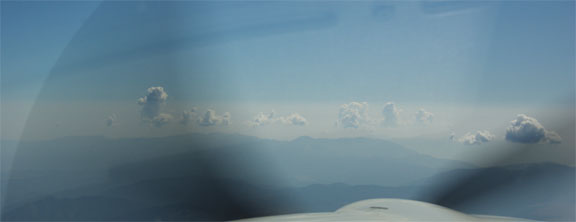
The forecast was to become overcast and sure enough by the time I got going there was a bit of cloud around. It was easily outclimbed
and by the time the filed level of FL120 was reached the flight was in clear conditions, above a layer of haze which made photography difficult due to poor contrast:
The rugged terrain of Albania does not offer a lot of forced landing opportunities....
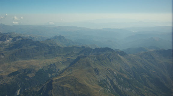
Tirana Radar issued a frequency for Skopje Control to be used in case of loss of radio contact due to terrain; sure enough I did have to switch over on my own.
Some cumulus was found over the last bit of terrain in Greece before reaching the sea. In an apparent attempt to fly the correct semicircular levels (which N. European IFR ATC doesn't care for) Thessaloniki Radar requested a descent to FL110 which I refused as it would have put me into the haze layer and they instead agreed to FL130.
There is some ambiguity concerning the name of the northern Greek controlling authority in this area. It is officially named Makedonia Control/Radar (LGMD ACC), but there is a long standing naming dispute between Greece and its northern neighbour FYRoM who via Skopje Control (the en route ACC) refrain from calling the proper name during hand off from one FIR to the other on southbound flights. They either ask you to contact just the frequency for the en route sector or Thessaloniki Approach for the airport's approach unit.
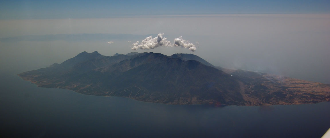
This is the island of Samothraki which was located to the right of the track; it is 5300ft high:
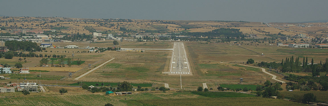
Canakkale is located only just past the Greece-Turkey border and the handover to Istanbul Radar was rapid at the last minute; the VOR DME 04 approach was allocated. The airport has some commercial traffic; it appears this is mainly internal Turkish passenger aircraft
Here is a 25x speeded-up video of the LDSB-LTBH flight; edited to remove IMC and a few other parts to get the size down:
Once on the frequency with Canakkale Tower, I read out the special permission code which Turkey requires for US (or any non-EU) registered aircraft. This code had been obtained for me earlier by the Fly-In organisers.
The airport is semi-military but there was no evidence of any military aircraft there. ATC were competent throughout, though Greece and Turkey do like to insist on flying the published airway routes, with no shortcuts.
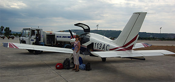
Avgas arrived immediately
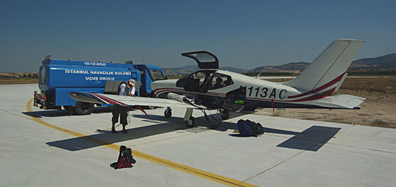
but was not only the most expensive I had ever paid (about Euro 2.70 per litre, based on the amount actually charged) but the bowser indicated about 4% more than my fuel flow totaliser said there was room for. These large errors are unheard of in northern Europe, do happen further south, and are amazingly always in the supplier's favour. In this case, the airport has no avgas and the Fly-In organisers got the bowser to drive there all the way from Istanbul...
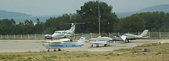
A large proportion of the visiting aircraft were Socata TBs - a pattern found in Greece too

I think the reason for the popularity of Socata's TB range is that the pilots in these countries - miniscule though they are in their numbers, at around 1% of the UK pilot population - are much more "style conscious" than northern European pilots, and this favours the relatively modern two-door TB aircraft over the more traditional Cessna and Piper types which dominate e.g. the UK scene. As Socata TB production ended in 2002, new aircraft purchases in this part of the world nowadays tend to go to Cirrus, which is equally predictable.
The Fly-In was an extremely well organised (by the Istanbul Aeroclub) and highly enjoyable gathering of pilots from a large area of Europe. These events are nowadays being regularly organised in this part of the world, to build friendships and international linkages between pilots and to raise the awareness of GA. Currently, with a perfect mix of the right sort of distances, poor transport links, widely spread out islands, etc, the whole area is ripe for GA activity but progress is being held back by airport management practices such as early airport closing times, lack of Avgas, lack of Customs, PPR for landing, PPR for Customs, PPR for foreign registered aircraft, pointless but mandatory handling, forms to fill in certifying nobody on board has tuberculosis, other forms to fill in, etc. In some places (e.g. Kerkira LGKR) the form filling process takes about 1 hour. There are also some apparent turf wars between officials and the HCAA; for example Kerkira LGKR notams 24hr PPR but the officials based there have asked me for 5 days' PPR "to manage apron capacity" - with a vast apron which is virtually empty nearly the whole time.
Some Greek pilots' photo albums are here: 1 2 3.
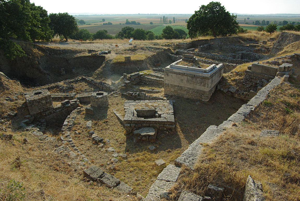
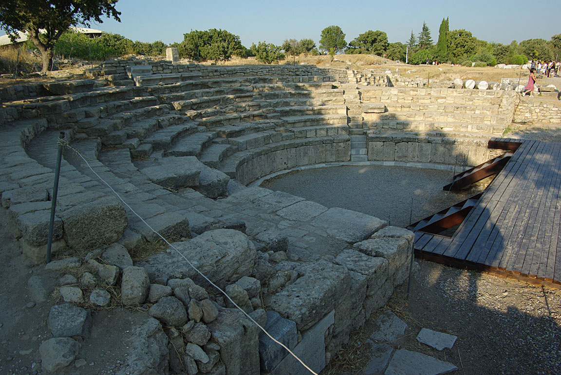
Canakkale has a lot of ancient history around too. We visited the ancient city of Troy - a partly excavated dig
A part of the fly-in was a trip to the island of Tenedos, known as Boscada in Turkey, on which one pilot has a short private strip

Canakkale (LTBH) to Lesbos/Mitilini (LGMT)
FL120
LTBH
BIG (SID) AMANI G8 LSV H59 MARIK (STAR)
LGMT
Alternates: Sitia, Crete LGST, Thessaloniki LGTS
198nm (airways); 65nm (GC)
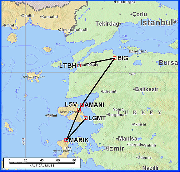
The above route, shown in full with its departure and arrival procedures, with its approximately 3x overhead over the great circle distance of just 65nm, is a really crazy example of how IFR routings can sometimes be ludicrously inflated, and ordinarily one might prefer a VFR flight in such cases.
But it got worse. I had filed my flight plan (using AFPEx) a couple of days previously. It appears that a day later Turkey drastically reduced the available routings out of Canakkale and only one - northern to GOLDO - departure was available. Someone on the fly-in discovered this route restriction, a quick look at the new Avbrief facility (available to Avbrief.com subscribers) which gives access to a new Eurocontrol feature whereby available standard routings are suggested confirmed it, and there was much talk of how people were going to get out of Canakkale, flying a nice "tour of the Aegean"
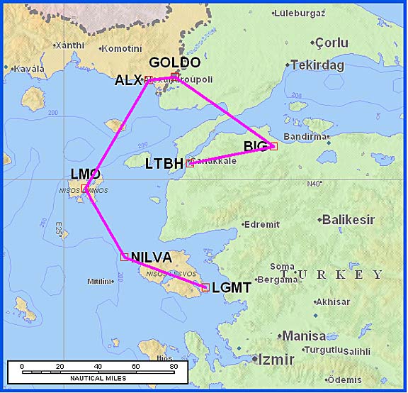
which in my case would have been 271nm and would have been even worse had LGMT not had the direct arrival from NILVA...
It is almost certain that this routing restriction was caused by the constant military flying activity across the Greek / Turkish border, where there are several intercepts each day of Turkish aircraft by Greek F16s. There is even a video of one of these on U-Tube. This is also why Greek ATC keeps traffic on the published airway routes; they would not be able to provide separation off the airways. If an incident (related to loss of IFR separation) occurs off airways then ATC are liable to get into trouble.
Note that the above pic shows "Mitilini" in the middle of the ocean and about 50nm west of where it should be; I don't suppose Jeppesen have many customers flying in this part of the world.
On the morning of departure, back at the airport, the airport operations officer did indeed confirm that GOLDO was the only route. This caused much consternation among pilots and one of them did not have enough fuel to get back home. The officer just smiled and shrugged his shoulders... I had allowed for 3 hours on the ground which turned out a good decision because in addition to the routing problem a very slow queue formed of pilots filing flight plans the old way. I don't know how many pilots here use Homebriefing but I know it is well known; in fact it was from a Greek pilot that I first heard of this service, several years ago.
I told the officer that I had filed a Eurocontrol flight plan on the "old" route 2 days previously and (a) this was accepted by Eurocontrol and (b) I had checked my AFTN terminal (AFPEx) that morning and there were no messages disputing it. He was suprised that I had an AFTN terminal - AFPEx is evidently quite an innovation. He called up the Tower and confirmed that this flight plan would be honoured. However, if I wanted to change it (e.g. to an earlier departure) then the new flight plan would have to be on the new routing. This was an interesting lesson: in some places, it really pays to file your flight plans well before the day of departure. Since each country has total sovereignity over its airspace, I doubt that Turkey has any obligation to honour standard routes they gave Eurocontrol some days earlier, but in this case they did so.
The weather was fine. The MSLP for 0600 and 1200 showed nothing significant. Tafs and Metars were OK too. Sferics showed some thin activity in the area and this could be routed around (assuming VMC).
By the time of departure (1100Z) arrived, the wind had got up to about 25kt gusting 35kt, but more or less straight down the runway. Temperature was an impressive +34C.
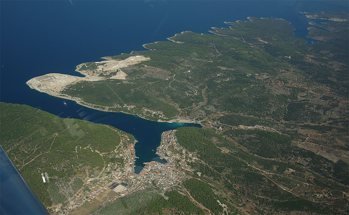
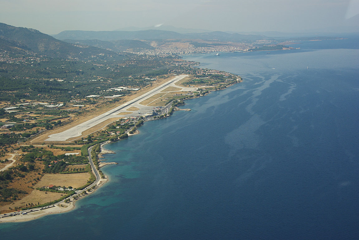
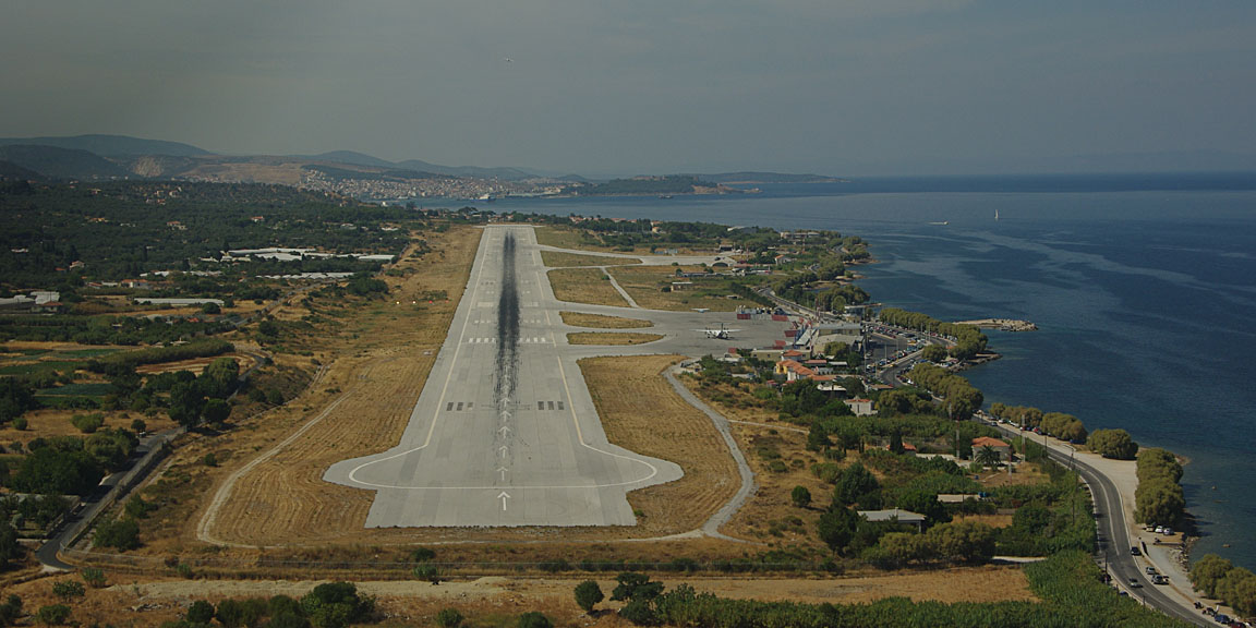
Istanbul Radar did not allow any shortcuts and insisted on flying the full distance to BIG before turning to AMANI. It was a short flight in hazy weather and I asked for a "stop climb" at FL100. Due to the close proximity of Lesbos to the Turkey/Greece border, the handover to Makedonia Radar was rapid and by then we were almost on top of Lesbos, making for a rapid descent into Mitilini LGMT; the following pic is on a heading of about 140:
The approach to Mitilini was a VOR approach to 14 with a right-base circle to land to 32. One reason for it being right-base is fairly obvious from the above pic (the hill!); somebody flying the conventional left-base (break to the right) circle to land might get a "suprise" if they did it in IMC... here's another one
and another reason is the very close proximity of the Turkish FIR which is just a few miles away, and there is the Greek/Turkish FIR dispute already mentioned.
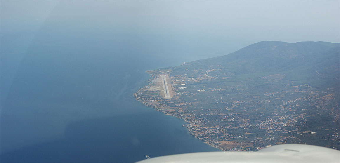
The airport is very close to the beach
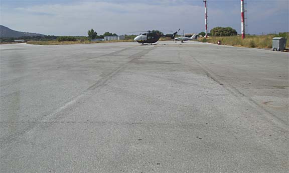
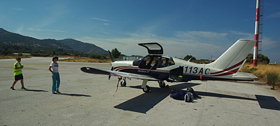
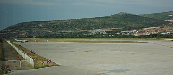
Taxi was behind a Follow Me vehicle. The "GA apron" - big enough for several hundred light aircraft - was empty apart from the helicopter
though a Cessna landed shortly after us - apparently just to clear Customs back to a non-Customs Greek destination, also on the way back from the Canakkale Fly-In.
Having filled up to max (86 USG) at Canakkale, we landed with 71 USG in the tanks which was plenty for the next destination - Split, Croatia - and very usefully eliminated the planned time wasting fuel stop at Thessaloniki.
The "handling agent" (Olympic Handling) arrived fast
and asked for the names of the First Captain, the Second Captain, and started the form filling process which continued inside the terminal where Customs relieved us of Euro 38 for being a non-EU-registered aircraft. It was claimed that this is necessary for Customs but in fact Customs had to be there anyway for any arrival from outside Greece (because while Greece has signed Schengen, it ignores it for anybody arriving in a vehicle or a private aircraft regardless of registration) and they had to be there for the crew of the Greek-registered Cessna. No doubt we will be relieved of another Euro 38 on the way back out, and if 100 N-reg aeroplanes arrived concurrently each would also be relieved of Euro 38... Apparently, 10 Euros of this Customs charge is for a "taxi" to bring in the Customs officer, but they charge it for each aircraft regardless.
The excellent organisers of the Canakkale Fly-In had provided us with the yellow GenDec form at the end of their Fly-In so this was handed to Greek Customs and was one less form that had to be filled in.
Mitilini has a small informal aeroclub comprising of about 50 people, of which about 10 have a PPL and are "mentoring" the others on their way to get PPLs. It must be tricky to operate out of there; they bring in their own avgas (not available to visitors) in drums.
The town of Mitilini is a lively place, with a large university student population which is visible everywhere. As one would expect from the island's name, female couples are very evident but are far less "obvious" than their male equivalents at Mikonos - or at our home town of Brighton for that matter :) Accomodation costs are reasonable; we stayed at the Porto Lesbos hotel for Euro 65/night and then moved to a self catering apartment for Euro 35/night. The latter was however pretty basic, with the only hot water coming from a small solar panel installation.
One less attractive feature of Mitilini is the crazy scooter traffic which together with narrow pavements makes walking around pretty unpleasant... It is not a place I would recommend for an extended stay; anywhere else on the island is going to be far nicer.
Internet access was sporadic, with nearly all wifi access points secure as is the tradition nowadays. The numerous internet cafes were full of boys playing games, cigarette smoke, knackered keyboards, and most did not allow the use of a laptop but we did find some very pleasant cafes with wifi. Suprisingly, the GPRS/3G radio in my Thinkpad laptop (T-Mobile, £1.50/MB, PAYG) "connected" but did not work (no DNS) but using my phone (Virgin, which also uses T-Mobile, costs £5/MB but has the coverage expanded to "contract" levels by a direct debit payment arrangement) as a modem for the laptop worked fine. I also carry an old Sierra 750 GPRS PCMCIA adaptor (with a £10/MB Vodafone SIM card in it) but this stopped working, with some kind of hardware failure. Winfax also stopped working; this was OK as nowadays I use an email2fax service which just needs an internet connection. As is always the case when travelling, having more than one way of doing this stuff is absolutely vital - internet access is absolutely vital for just about everything to do with flying.
We did a day boat trip to Turkey, to the town of Ayvalik, for an amazing 5 Euros return. The boat was packed full of Greek housewives buying up cheap domestic items e.g. tablecloths, brooms etc and bringing back suitcases full of this stuff, but some groups of men transported whole furniture suites. Turkish prices are a fraction of Greek prices. Apparently, Greeks can travel to Turkey easily but Turks cannot simply travel to Greece; they need to get visas which need evidence of financial means, etc.
We visited Mitilini Castle which is really worth seeing. It was built in Byzantine times, later added to by the Genoese, and then extended by the Ottomans with some fancy plumbing...
Lesbos - Justine's highlights
Eating in local tavernas - you can feast for under EUR10 a head (with drinks) in the vine-shaded side streets (lots off the main shopping drag, Ermou and towards the north port). Go for the fresh and seasonal options - stuffed pumpkin flowers were wonderful in September.
The fortress - an amazing structure in about the best location for photos anywhere on the island. See how long you can make an echo last in the water cistern, and look for the wild herbs that grow everywhere - fennel, dill, rosemary, lavender and scented geranium.
Methymna/Molyvos - justly famous second town of Lesbos, with very consistent local stone houses and better craft and curio shops than you'll find in Mitilini. The almond pastries at the Women's Agricultural Cooperative are heavenly.
Ouzo - Lesbos is supposed to make the best in the world and you can find a dozen or more varieties in many shops and bars. Walk past the Veto distillery opposite the ferry terminal and breathe in the aniseed aroma.
Day trip to Turkey - you can go shopping in Ayvalik for EUR5-30 return depending on the day, season, boat and operator. For the cheap fares you need to ask around the agents on the waterfront and towards the ferry terminal. Be prepared for a long but fascinating day and take something to read - you'll be on the boat for up to 2 hours each way. Some operators also offer 1-2 day trips to Pergamon and Izmir.
New archaeological museum - superb Roman mosiac floors salvaged from beneath the streets and houses of Mitilini, just a fraction of what you're probably walking over all the time.
And a few lowlights:
Traffic! Don't stay in Mitilini town if you're after peace and quiet or are less than nimble at dodging anarchic drivers.
Stray/free-range dogs and cats. Mitilini is awash with them and they are a real nuisance. Half the animals on the streets seem to be pets, and perhaps the owners think they are being kind letting them roam free rather than holed up in a flat. At the Lesbos shop (central waterfront) you can donate to a charity that looks after and sterilises the strays.
Rip-off restaurants - be suspicious of anywhere the locals aren't eating, especially in prime locations. If you order fish that's charged by the kilo make sure to agree the weight beforehand and check that you pay only for what you agreed. We ordered a fish the waiter said would be 400g, but were charged for 600g. It seems paranoid to suggest checking the weight too, but considering the paltry size of our dinner we probably should have.
Homelessness and poverty – we were upset to see children begging among the cafes of Mitilini, down and outs sleeping in doorways, and whole families living in tents near the bus station. Many seemed to be Roma or immigrants but apparently homelessness is increasing generally in Greece owing to hard economic times.
Lesbos (LGMT) to Split (LDSP)
FL120
LGMT
LSV H59 ERESO/N0176F130 N128 PEREN M603 TSL B1 TALAS N132 MAVAR Y400 RETRA L604
POD W47 TAZ R45 DBK L607 SIPAL
LDSP
Alternates: Thessaloniki LGTS, Dubrovnik LDDU, Brac LDSB
562nm (airways); 536nm (GC)
On a 2-week trip, any forecasts of the return weather will be mostly fiction, so one has to take a chance on it when departing, and review the situation during the last few days of the trip - and grab the first available opportunity. On all past trips to Greece and other long-distance locations, this worked out fine although there were often last-minute doubts and some hectic "just in case" replanning. On some occasions Justine (who does not like flying in turbulence) took a commercial flight back home although in every such case I had a perfect flight back in the TB20, the same or following day...
This time, things were harder. The UK was enjoying excellent weather while the Aegean and the Adriatic areas were getting a lot of convective activity e.g. 1 2 which manifested itself as scattered thunderstorms which were in some cases probably embedded in IMC.
Moreover, the long range GFS forecast for Prague LKPR - for what a 7 day forecast is worth; not a lot - was showing Prague to be a wash-out around the time we would have to be there, with a mass of frontal activity. The Prague weather could not be predicted this far out but the situation there was clearly unstable, providing ample opportunities for getting stuck for a few extra days, and this would have caused problems due to the already long time away from work, etc. Prague is a lovely city but is not a great place to be stuck at for days, with expensive hotels and an ultra expensive airport, and one would definitely want to fly the aircraft out of there - to almost anywhere - at the earliest opportunity.
We therefore decided to re-plan somewhat. The flight to Split LDSP would still be done if possible but after that we would almost certainly skip the Prague part and head back to the UK at the first weather-decided window of opportunity. For Justine, Split also offers an easy way back to the UK on a commercial flight. Getting back commercially from Mitilini is possible but a lot more complicated since the only scheduled flights to London are by Thomson on Thursdays; more frequent flights with convenient transfer timing (avoiding an overnight stay at e.g. Athens) are all expensive. For me, Split offers two practical ways back to the UK: via Losinj LDLO which is an easy short VFR flight from Split and from where the UK can be reached directly over the Alps, and via Cannes LFMD in the south of France which avoids the whole Alpine/German weather system.
At the 2- or 3-day look-head point, on Friday, both Sunday and Monday looked possible, but Tuesday did not look as good, with a nasty occluded front over Slovenia which could well work its way down during the intervening days.
However the following day (Saturday) everything changed around... the first flyable day was Tuesday... Obviously all these charts are just rubbish at times. On a weather course I once attended, the UK Met Office forecaster told me that one could put 10 forecasters in a room with the same data and all 10 would draw the troughs in different places... The general pattern of the Lows merely means there is a statistical tendency for convective activity. Of course, convective activity takes place almost anytime the sun is shining anyway; the real question in this case is whether the tops of the organised IMC exceed the aircraft operating ceiling enroute, and whether one can safely climb/descend in the terminal areas.
On Saturday evening, the NOAA GFS data for Sunday showed LGMT and LDSP both OK so it was decided to provisionally go on Sunday and look at the satellite images on the morning of the proposed flight.
One alternative, which like Split would also allow an easy commercial flight back, was Corfu/Kerkira LGKR but this airport quite pointlessly demands 24hrs PPR in writing, which was duly requested the previous evening, by AFTN, fax and email; the permission was received by fax but only the following morning and too late. Mitilini LGMT is also "Customs PPR" and as this was a departure to a non-EU country (Croatia) they want a good few hours' notice because, it was claimed, the Customs officers might be back at the shipping port processing some ship from Turkey. Quite how they manage to process the good number of incoming airliners every day, is a mystery. I strongly suspect there is a certain "ambiguity" there when it comes to non-EU registered aircraft; the 38 Euros is applied in such cases but when one questions it with a different person, one is told this is due to the non-EU arrival or departure. Exactly how Schengen comes into this I don't know; Greece has supposedly signed it but the Customs people did not mention this at all.
More "spanners in the works" were dropped in the morning of planned departure. Firstly, there was a widespread power cut for a couple of hours, cutting off internet access (which was already extremely slow the previous evening, most likely due to somebody in the hotel doing massive downloads). . Luckily my laptop was fully charged (and has a ~ 7 hour battery life) but I had to use my phone as the modem, spending around £20 on 3G just doing the basics. Then I discovered that while I had preplanned the flight with a fuel stop at Thessaloniki LGTS, I had not done a route without a fuel stop, and the nonstop route was slightly different, and had to be regenerated and revalidated (that bit was easy, with Flight Plan Pro). But I also wanted a proper printed plog and enroute strip charts.... and then my little Canon IP90 portable printer ran out of ink!! Fortunately, the laptop lives in a sturdy attache case in which I carry various bits including spare ink cartridges...
On the morning of departure, the infra-red satellite image (which shows cloud temperatures and thus roughly indicates how high the tops are) showed fairly dark cloud around the proposed route (shown in yellow). Some satellite images come with a temperature scale but I know this cloud brightness is nowhere near ~ FL300 kind of stuff. Moreover the 0600 and 1200 SigWx forms indicated nothing too exciting. The 0600 1200 1800 MSLP charts showed the widespread instability... The tafs and metars showed reasonable weather, with the expected PROB30 TEMPO thrown in. The Meteoblue image showed a feasible flight, with tops around 600mb. Finally, the sferics picture was clean.
So, off we went. The local weather was good, with some scattered thin cloud around 5000ft and (around 8am local) no buildups.
The airport processed us fairly efficiently - by some Greek airport standards. The CAA office charged just 12 Euros; when I queried this in amazement (landing and 6 nights' parking) I was told that all landings and parking are free during that month of September. The reason was to stimulate traffic numbers depressed by the economic recession. Olympic Handling charged about 30 Euros for "handling" - basically just the two ~ 200m bus rides. The whole process took half an hour. As on our arrival, the apron was empty.
The apron slopes significantly towards the grass verge, so we left a massive A380-sized chock behind one of the wheels, otherwise the aircraft would run off the concrete as soon as the brakes were released, if one was not paying attention - easily done during a somewhat hurried departure.
We departed 15 minutes after the filed EOBT. The flight went fine. None of the weather data matched what was actually found but the IR satellite image turned out to be accurate, in that there was a cloud layer most of the way, with tops FL120-FL160.
By the time we reached the Greek mainland, there were spectacular cloud formations to the west of our route; the following pic was taken around FL140
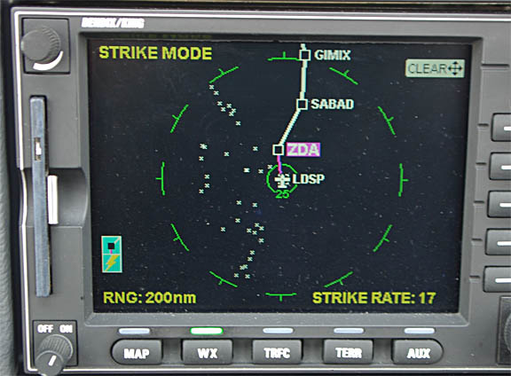
All the stuff could have been outclimbed if we really wanted to but there was no need as the route ahead was clear at our level. About halfway, strikes started to appear on the stormscope
and one could see the likely sources easily enough
and while some appeared close
they were actually many miles away and would have been easy to route around. All kinds of airlines were on the radio asking for heading changes "to avoid" and ATC were excellent.
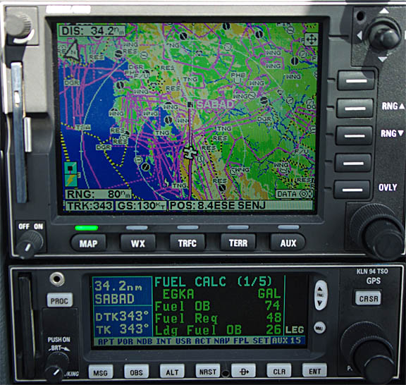
Except for the Greek part (which had to be flown strictly on airways) all other ATCs were excellent and most of the flight was done as a series of DCTs, one of which was nearly 200nm. As the above GPS pic shows, the Landing FOB remained around 28 USG and fell down to 25 only at the very end when we had to climb to FL170 to clear rising cloud tops.
The suprising thing was how for example Belgrade (whose airspace we barely touched) were able to provide a service practically all the way to the Split ILS; the various bits of former Yugoslavia seem to co-operate well today. Tirana suffered from a poor radio reception due to terrain - even with us around FL160 - and one Swiss airliner relayed messages between us and Tirana.
In a scenario where there are various buildups around the place, which within say 15,000ft of vertical cloud can hide a nasty TCU which is going to be very rough and if starting at say -10C could well be penetrated above the freezing (0C) level and thus be hazardous, one needs to descend carefully through this kind of stuff, on a track along which the cloud top surface is relatively smooth and thus is not hiding anything. With around 30nm to run, I asked for a rapid and continuous descent to the lowest possible level, and got one from Split Approach from FL170 down to 6000ft. To descend at -1200fpm yet keep the speed below Va (~130kt) the landing gear and approach flaps were extended on the way down to get extra drag. We popped out underneath into fine if dark and drizzly weather
and were radar vectored to the ILS 05 approach; the following pic shows the airport just to the left of the centre
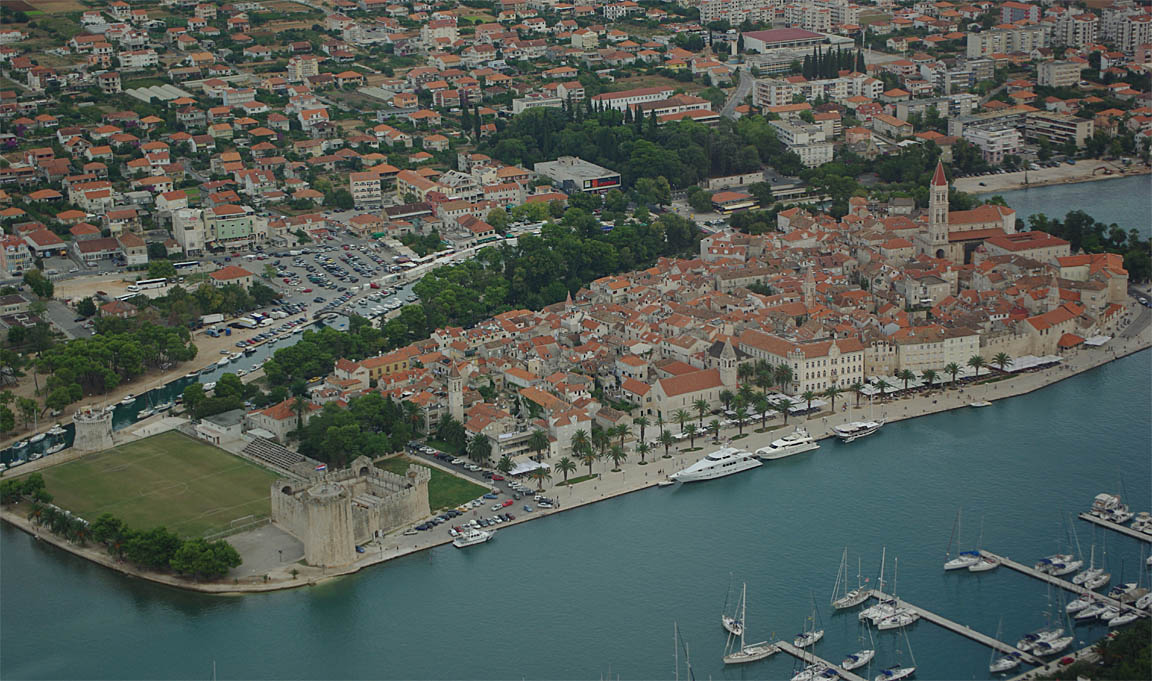
over a nearby city (Trogir)
to the final; the following pic shows why the approach plate is pretty specific about the missed approach climb gradient...
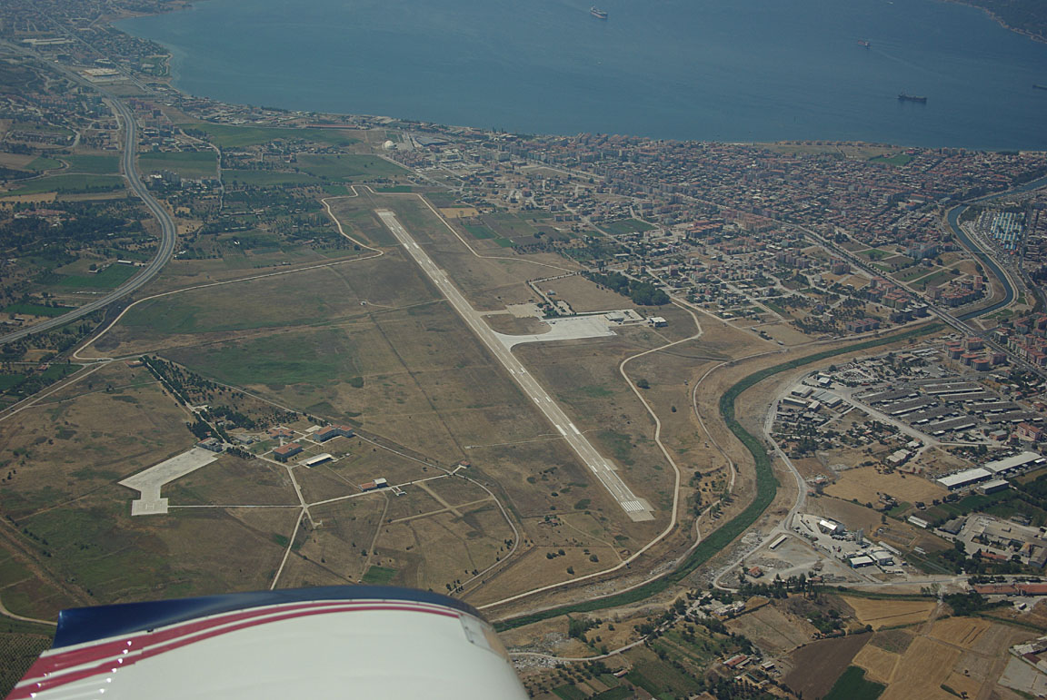
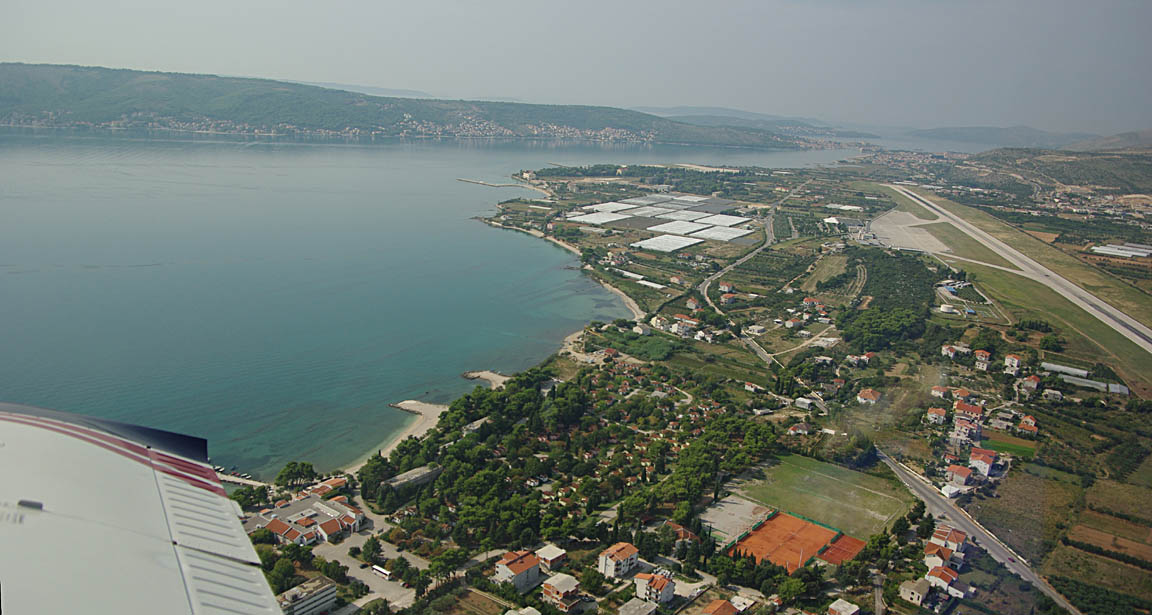
Split is a big airport
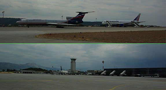
but is very efficient and as with every other place I have flown to in Croatia it seems to have a total "can-do" attitude to GA. We were met by their GA handling and refuelled immediately
and processed within minutes by a very helpful man who even phoned some hotels for us. None of this silly Greek form-filling and PPR nonsense... The GA desk is upstairs, in the main terminal, and very easy to find. There is a decent size GA apron which is conveniently very close to the runway
The fill-up from their bowser was 2.5% out (again in the "wrong" direction) but this is a reasonable error especially given the parking in Turkey in the hot temperatures which can cause some fuel to evaporate through the vents.
The hotels all proved to be suprisingly expensive (upwards of Euro 150/night) but we quickly found some very nice private rooms for 1/5 of that, right inside the old city. The airport bus to the city centre was 30 HRK (around Euro 3) which is 1/10 of the cost of a taxi.
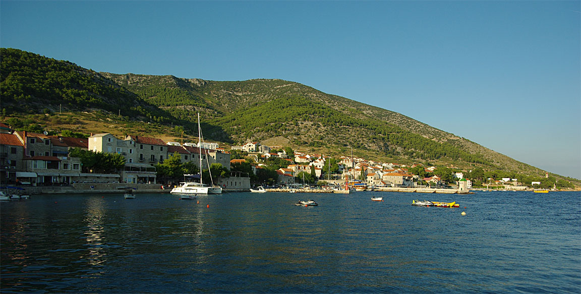
Perhaps the best known attraction at Split is Diocletian's Palace. Apart from that, it is a very good location for boat trips to the nearby islands, and its excellent integrated transport set-up makes it easy to travel elsewhere in this part of Europe.
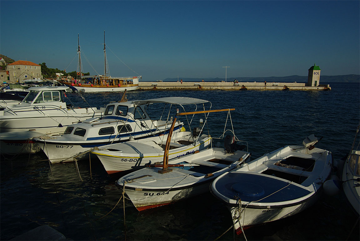
We did a boat trip to the town of Supetar on the nearby Brac Island. This is really highly recommended - it's a lovely place.
Croatians go for romantic songs - it is the only place where you will hear Engelbert Humperdinck's Release Me and Tom Jones' Green Grass of Home played in public :) It is very similar to how I remember Czechoslovakia from the 1960s...
Split and Supetar (Brac Island) Picture Gallery
Justine's Split Highlights
Diocletian's Palace - check out the basement to get an idea of the original layout.
Riva - Split's spotless waterfront promenade is the place to linger over a lager for locals and tourists alike. We thought the public nutcracking table and stone thrones were an innovation every city should adopt.
Ferry to Brac Island (and Hvar, Vis etc) - just one hour and 30 Kuna later you can be in another world. Ferries run like buses - just turn up, buy a ticket, check the display board for the next sailing and off you go.
Room touts - the guidebooks warn against them but if like us you arrive to find Tourist Information closed and all the hotels overpriced and full, these people can be a godsend. We found a nice clean room right in the heart of the old town, with wifi, for 350 Kuna per night. Do your homework though: make sure the location is central, see the room before doing the deal, get a receipt, and if you can check the price on the Internet (our room would have been 300 Kuna booked online!).
Local stone - white stone from Brac Island is world-famous. We bought a bowl and a pestle and mortar to remind us of our trip.
Market - at one end of the Riva near the bus station is a fantastic market where you can buy everything from fruit and veg (perhaps the only place you will ever see farmers selling both blackberries and figs) to ironmongery, clothes, suitcases, etc.
Lowlights:
Tourist Information closes at 2pm on Sundays and doesn't reopen.
Avoid the posh delicacy shop on the Riva. The chocs are about £1 each and nothing to write home about.
Economic hardship - Dalmatia has always been the poorest region of Croatia
and we read that the average income is around EUR350 a month. Not hard to see
why the markets are so popular and the smart shops so empty.
Capitulation...
Around the planned date of the departure from Split, the weather situation was again difficult, with constant frontal activity north of the Alps and over France, thus blocking the two possible routes back to the UK: direct from Croatia, and via Cannes LFMD.
By this time I was getting fed up with the difficulties, and decided to either fly back home over the next few days, or leave the aircraft at Split, get an airline back with Justine, and retrieve it later. There are easy and cheap daily flights from Gatwick to Split so this is not really the problem which it might be if the aircraft had been left at some aiport not served by UK-going airlines or at an airport with huge parking charges (e.g. Prague).
The following originally planned flights were scrapped.
Obviously, the favoured return flight would be from Split direct to Shoreham. However, this is about 900nm and as it would be likely against the prevailing winds, a fuel stop could be made at Losinj - an island near the very top of Croatia which is also very pleasant for a stay if necessary. The Losinj stop reduces the distance to the UK to 790nm. Other options are Friedrichshafen or St Gallen but the fuel is considerably more expensive there than in Croatia which is not in the EU.
On the planned day of departure (Wednesday) the weather on the satellite image was not flyable, with probably very high tops and some TS activity to make life extra interesting if one chose to fly in IMC... The 0600 SigWx was not great, and the MSLP charts 1 2 3 4 did not show any clear improvement. The wind map looked good though, with a very unusual situation where one might end up with a net tailwind when flying west.
So around 5am on the day, I bought an Easyjet ticket for £200 departing at 10am, and planned to retrieve the aircraft a few days later
I informed the Split GA office and they advised there is no problem parking as long as I need. Parking (1400kg) is Euro 8 per 24hrs, halving to Euro 4 below 1200kg. At this rate, the airport probably has a few "long term" parked aircraft
though not as many as Granada LEGR where several had grass growing around the flat tyres.
Funnily enough the Easyjet flight was delayed by a number of hours and had I flown back in the TB20 I would have got back home earlier...
There is a daily flight from Gatwick to Split and there is even an early morning one which would enable the aircraft to be recovered all the way to the UK on the same day.
The decision to cancel was right as an IR image taken a few hours later (the airline flight was delayed by some hours so I had a chance to check the weather again online) did not show any improvement. It was right to cancel anyway on the basis of the flight being PROB99 unable to be VMC enroute, given that the 0C level would be below the MSA in places.
The 1800SigWx (I missed the 1200 one) is interesting in the way it describes the weather (see zones 5 or 6) as "ISOL/EMBD CB FL100-370" [my bold] which is semantically correct but there is a world of difference between "ISOL CB" in VMC and "ISOL CB" in IMC which is solid up to FL370 which was the actual situation observed from the A320, which was in solid IMC from about FL100 to FL360 and was evidently unable to avoid quite a bit of the turbulence. The EMBD means that the CBs can be expected to be embedded in IMC which makes for the most hazardous weather. This example demonstrates the caution with which the SigWx form needs to be regarded for GA operations; it does not show cloud tops and is really geared up for aircraft equipped with radar and excellent de-ice equipment.
A final post-mortem on the cancelled flight was this Skew-T for just a bit north of Split, showing solid IMC to way above the TB20 operating ceiling, with a 0C level around 10,000ft which is well below the MSA.
Aircraft Retrieval
Obviously the most convenient route is a nonstop flight from Split. This is about 900nm and I would not do it against any significant headwind. The aircraft can fly for 1300nm in zero wind, to zero reserve, so wind is the only issue.
The next option is to refuel at Losinj LDLO and fly to the UK from there. This is 791nm (airways), 700nm (GC):
This shortens the trip by about 110nm while ensuring that the fuel stop is at a very convenient airport free of the traditional European administrative nonsense. The flight from Split to Losinj could be done as a low level VFR flight (with great scenery all along), or at a high level from which one could see what it looks like above the Alps.
The final option, for significant headwinds, is a halfway stop which could be for example St Gallen (closed 1000-1130Z) or Friefrichshafen, or similar.
Due to the low winds, the direct flight option was chosen.
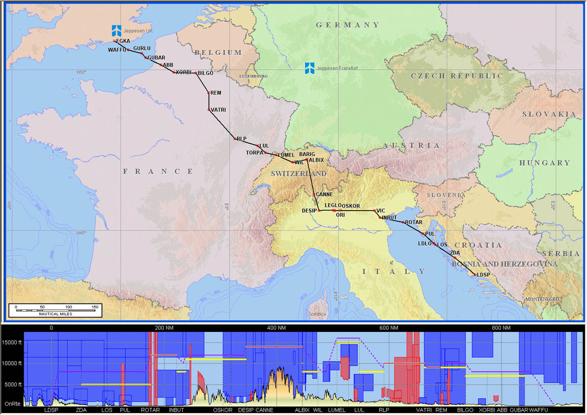
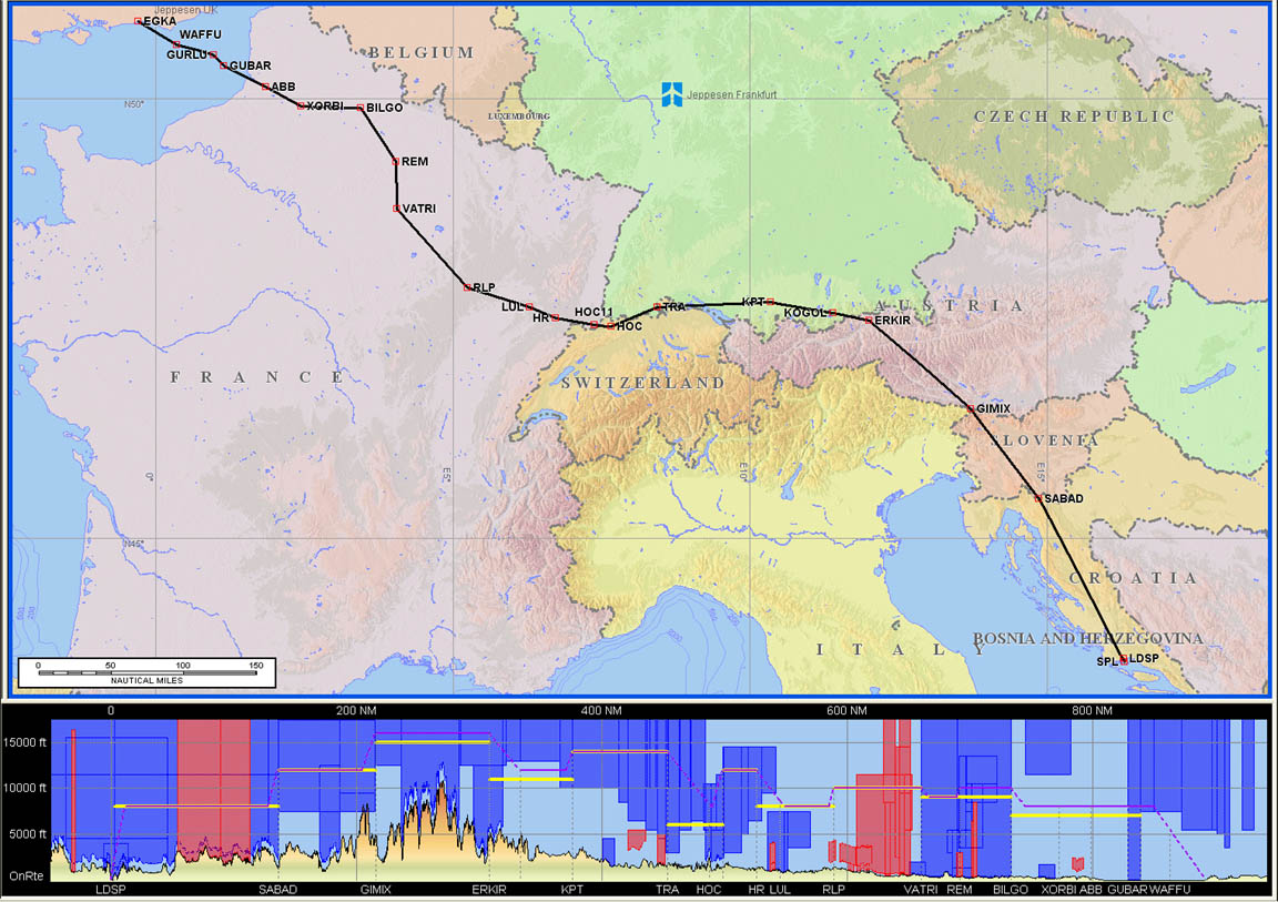
Split (LSDP) to Shoreham (EGKA)
FL160
LDSP
SPL L862 GIMIX L608 KPT L856 HOC G4 RLP B3 BILGO H20 XORBI H40 ABB T27 GURLU
DCT WAFFU DCT
EGKA
892 nm (airways); 803nm (GC)
Alternates: Brac LDSB, Losinj LDLO, Ljubljana LJLJ, Friedrichshafen EDNY, Lydd
EGMD, Bournemouth EGHH
Three days were examined for weather: Sunday Monday and Tuesday. Tuesday looks the best. There isn't much wind in the area, suggesting that a direct flight would work fine.
There are two airway routes which are curiously within 0.1% of each other in distance. The first one is usually generated by Flight Plan Pro
while the following one is obtained from FPP by specifying a fly-through waypoint such as GIMIX
One might ask whether the 1st option would be a better "bet", due to the possibility of the "obvious" shortcut between Italy and Switzerland (VIC to ALBIX via RESIA - an intersection not shown in the pics) but I have done the 1st route a few times and never got the shortcut. There are no airways there below FL200. One can fly that shortcut under VFR (FL129 max because Swiss ATC will not allow transit of their Class C which has a FL130 base) with spectacular views and I did actually do that in 2004 but on this occassion that would have placed the flight in solid IMC, in icing conditions, and about 1500ft above the mountains... not a great idea. On a nice day, it may be possible to file an IFR-to-VFR-to-IFR flight which does that shortcut under VFR - I wonder what ATC would make of that?
Both routes were planned and the 2nd route would be chosen if there was a lot of high cloud (above FL180) over the Alps. Also planned was a route with a stop in Switzerland or Germany. The various routes are here.
The Meteoblue images (whose reliability is somewhat dubious, but they have a place in building the bigger picture) for the first route for Monday and Tuesday suggested either day would be flyable within the aircraft ceiling.
On the often-confirmed principle that one should always fly on the first available technically flyable day even if the following day looks great, I decided to go on Monday if at all possible.
The 0600 and 1200 SigWx forms looked OK. The 0600 and 1200 MSLP charts looked OK, with troughs showing but I was going to ignore those because the forecasters seem to draw them anywhere they feel like, and go on the IR satellite images instead.
Early Monday morning, the 1800 SigWx looked OK. The vital IR satellite image also looked clean. The wind picture suggested ~ 15kt tailwind initially, then nothing, then a headwind of ~ 15kt on the last part. The wind image also shows the 0C level which was well above the MSA for most of the route, allowing an escape from icing conditions. TAFs for some airport along the route were also OK, with a possible scattered low cloud at the UK end.
On Monday I took an Easyjet flight to Split, landing there 0700Z. The plan was to check the weather that morning and if not flyable back to the UK nonstop, I would fly to Losinj LDLO (a very pleasant place to stay in anyway) and spend a night or two there; a slightly risky strategy because getting back from Losinj commercially would be a big job. The airliner flight provided an obvious opportunity to size up the weather; initially the cloud tops looked far too high but then I saw the Alps sticking up through so obviously the tops were well below FL150. After landing, I asked the pilots which route they flew and it was roughly via RESIA, so representative enough...
At Split, the formalities were done very efficiently. While sitting in the GA office at Split, more weather was obtained using my laptop (I had 3G but found a free wifi network...). The IR image was still OK (the cloud showing over the SE UK is not an issue because one can fly the last section at a low level, by dropping out of the airways system and continuing "VFR") and the sferics picture showed reasonably scattered activity. I immediately filed the flight plan using AFPEx, in a couple of minutes, for a 0900Z departure, which gave me plenty of time to get sorted.
The northerly departure from Split is a right turn (can't turn left due to terrain)
There was plenty of convective activity to the left of the route, especially over Italy
and in the distance one could see some of it
The Croatian islands
were seen briefly as the route then went over land towards the centre of Slovenia rather than along the Adriatic. The Landing Fuel on Board figure stabilised very early, at around 26 USG
and changed very little for the next 6 hours... The filed level of FL160 was well chosen given the cloud tops
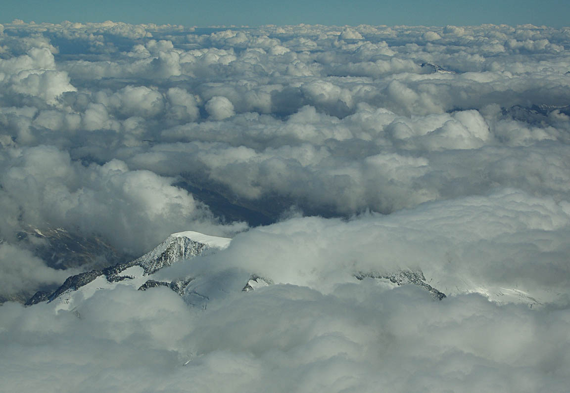
The temperature was about -10C. Here is Innsbruck - not a great pic due to haze - with the airport visible in the upper part of the pic
Curiously, the main part of the Alps was shrouded in a thick layer of cloud of just the right thickness to hide them - this pic was taken from near Zurich, looking south

As I had discovered with huge hassles in past years, getting oxygen refills is almost impossible when on the move. So, on this trip we carried all three oxygen cylinders that I have accumulated over the past few years - the top one is a carbon/kevlar composite one
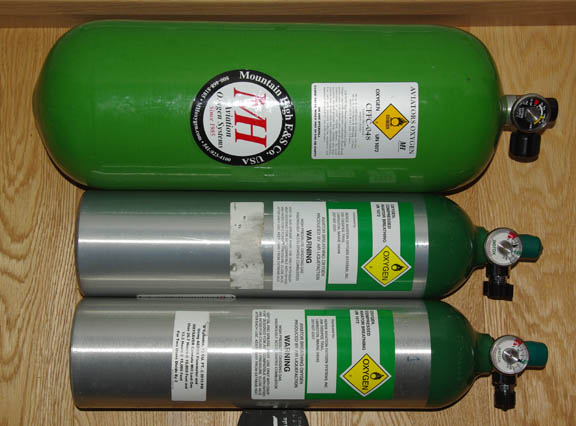
and since that one (which normally lives in a dedicated carrier behind the right-hand seat, and alone suffices for most long trips) was almost empty and had been moved to the luggage space and out of my reach, I was down to the two small ones. Since one of them would probably not last the flight, I left them on the front seat to be within easy reach for the changeover
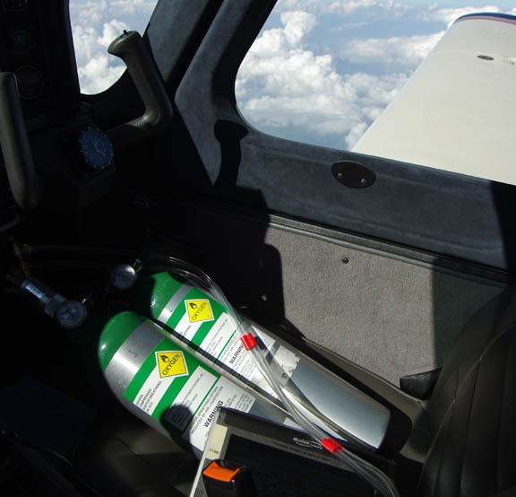
and, as expected, I had to change them over with 2 hours to run to destination. The changeover takes only seconds.
Since the forecast for the UK had a possibility of low cloud, about 3 hours earlier I used the Thuraya/Hughes 7100 satellite phone to get the weather for a collection of possible destinations. It was fine...
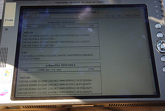
The connection time was around 1 minute which cost about US$ 1.00. Not a bad facility to have!
The first half of the flight was at FL160 and then I was able to drop down to FL140 which improved the speed quite a bit; however the LFOB figure did not change significantly.
I tried every possible worthwhile shortcut but none of the "good" ones were granted, although I did get some DCTs of 80-150nm in length. Eventually, Paris Control gave me a "direct to destination" with about 150nm to run.
An odd thing happened on this flight. About halfway, I was assigned a new squawk. This is unusual in European IFR - unless flying at levels low enough to be the traditional province of VFR traffic (e.g. FL100 in France which would be mostly Class E) - and if this happens close to UK airspace it may signal the imminent loss of one's IFR clearance especially if the new squawk is 7xxx. But in this case was I was high enough to be definitely in controlled airspace... Three more squawk changes later, followed by a question on what my destination was, it became apparent that my flight plan had somehow got lost. It was finally re-generated (or found) when over France, and all was fine after that. I never got the original departure squawk back though.
About halfway across the Channel, London Control gave me a descent from the FL140 cruise level; initially to FL120 and shortly after that to below the base of controlled airspace. When I selected -500fpm on the autopilot, trying to achieve a nice fuel-efficient continuous descent profile all the way to Shoreham, they immediately came back and demanded -1500fpm minimum... not a problem.
Total airborne time was 6:55 - exceeding my previous longest flight by 5 minutes. Landing was with 25.5 USG on board, and the actual pump fill was 1.2% off the computed figure i.e. about 1 USG. Reserves were ample - at the Swiss-French border the flowmeter/GPS was showing sufficient fuel for another 864nm which must be somewhere in Scotland...
Split to Shoreham flight picture gallery
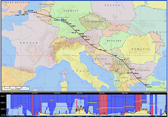
The actual track flown is here, plotted onto a well out of date ONC chart which is all I have with this coverage
with a GPS track file (423k) here. The vertical profile is below
which shows the two FL160 and FL140 sections, flown around 700ft too high in terms of altitude. This is about right, given that data logger GPS over-reading the altitude by ~ 200ft, and the QNH varying from 1019 to 1026 along the route.
Weather post-mortem: The SigWx forms were not far off in where the convective activity was happening. At the UK end, the forecast SCT007 turned out to be nonsense - it was a clear day over a huge area.
Sure enough, the Tuesday IR image looked great but the decision to fly on the first available day was still correct.
Flight times (airborne):
EGKA-LDSB 6:20
LSDB-LTBH 3:35
LTBH-LGMT 1:10
LGMT-LDSP 4:50
LDSP-EGKA 6:55
Fuel prices in Croatia were much higher than in past years. This time we paid HRK 12.71 which is about GBP 1.60 per litre. This price includes 23% VAT.
The aircraft performed perfectly.
One fun observation is that looking at the fuel actually burnt on the first two legs, the whole trip EGKA-LTBH of about 1325nm could have been done nonstop given the initial tailwind - by a cowboy landing with a few USG in the tanks
Lessons Learnt
Without doubt it was the usefulness of the IR satellite images, when the weather involves instability over a large area, with no clear frontal features. It is easy to get the IR image on the morning of the flight, and it does not change a great deal over the next few hours. EUMETSAT offer a commercial product where one can purchase the images, at a reasonable cost. I've known about this for some time but never got around to paying for it. Presumably those will also have the proper temperature scales on them so the cloud top temperature (and thus approximate altitude) can be estimated more reliably. These images are available freely around the internet but with a delay of some hours... The UK Met office ones used in this writeup are examples from the same source, and are up to date, but the temperature scale is missing.
I will try to get the PPR request form translated into several languages.
Any feedback, reports of dead links, corrections or suggestions much appreciated:
Contact details
This page last edited 5th January 2011
