
Trip to Granada - September 2008
Objective
This article describes an IFR (airways) flight from Shoreham (EGKA) in the UK to Granada (LEGR) in Spain. The return journey was to include a stop at Zaragoza (LEZG).
This flight was my longest one to date, in terms of both distance and airborne time, and required very careful fuel management. Fortunately the aircraft has a precise fuel flowmeter (accurate to < 1%) linked to the GPS so the pilot has a continuously updated forecast of fuel remaining at the planned destination.
The format of the flight is very similar to other airways flights I have done e.g. Prague. Other VFR and IFR trip reports can be found here. With the exception of weather strategies, IFR (airways) flying follows a standard pattern.
Here is a glossary for non-aviation readers.
Aircraft
The aircraft is a 2002 Socata TB20GT which has a zero-fuel "book" range of approximately 1100nm and a cruise speed of 155kt TAS at 10,000ft. Extra economical cruise power settings can extend the range to 1300nm. It has a ceiling of about 20,000ft and is equipped with oxygen. It is not certified for flight into icing conditions but has a TKS de-iced propeller.
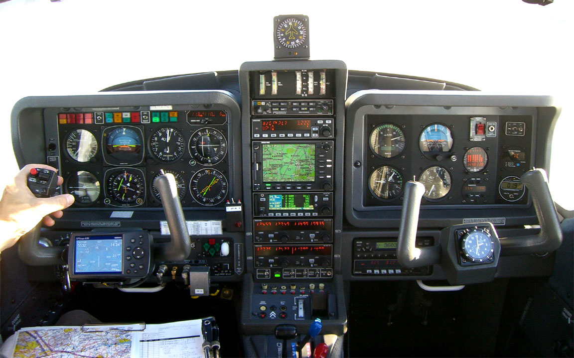
Navigation equipment includes a KLN94 IFR/BRNAV GPS and a KMD550 MFD and these are used for primary navigation. The aircraft has a KFC225 autopilot which can track VOR/GPS/LOC/ILS and fly a preset altitude or VS. There is an additional battery powered Garmin 496 GPS which also provides an audio terrain warning (TAWS) function with a European terrain and obstacle database.
Equipment
On any significant trip I carry a laptop (Thinkpad X60s 1704) and sometimes the Canon IP90 lightweight portable printer
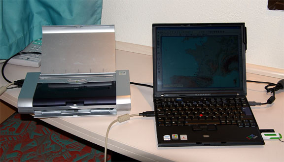
The laptop carries flight planning software (Navbox for VFR and Jeppesen Flitestar for IFR/airways), and also approach plates and enroute charts in electronic format (Jeppview). It also has internet access via WIFI, GPRS and 3G. This enables one to get weather, notams, file flight plans, send faxes to airports, and for longer trips it enables routings to be re-worked anytime on the ground. It can also connect via bluetooth to a Thuraya satellite phone for internet and fax functions anywhere.
Most importantly, it achieves independence from airport weather briefing and flight plan filing services which at best are an unpredictable waste of time and may be missing altogether. Obviously all possible planning is done before departure, at one's home where internet and printing cost virtually nothing.
European IFR Airways Route Generation
This has always been a difficult process because the European airways system contains a huge number of rules and restrictions, with thousands of changes loaded into the database every day. Eurocontrol/CFMU have never made their in-house route generation tools or the current airway database available externally, though they do offer a route validation website. Some notes on the subject are here.
However, this time I used a new software tool: AutoPlan route generator
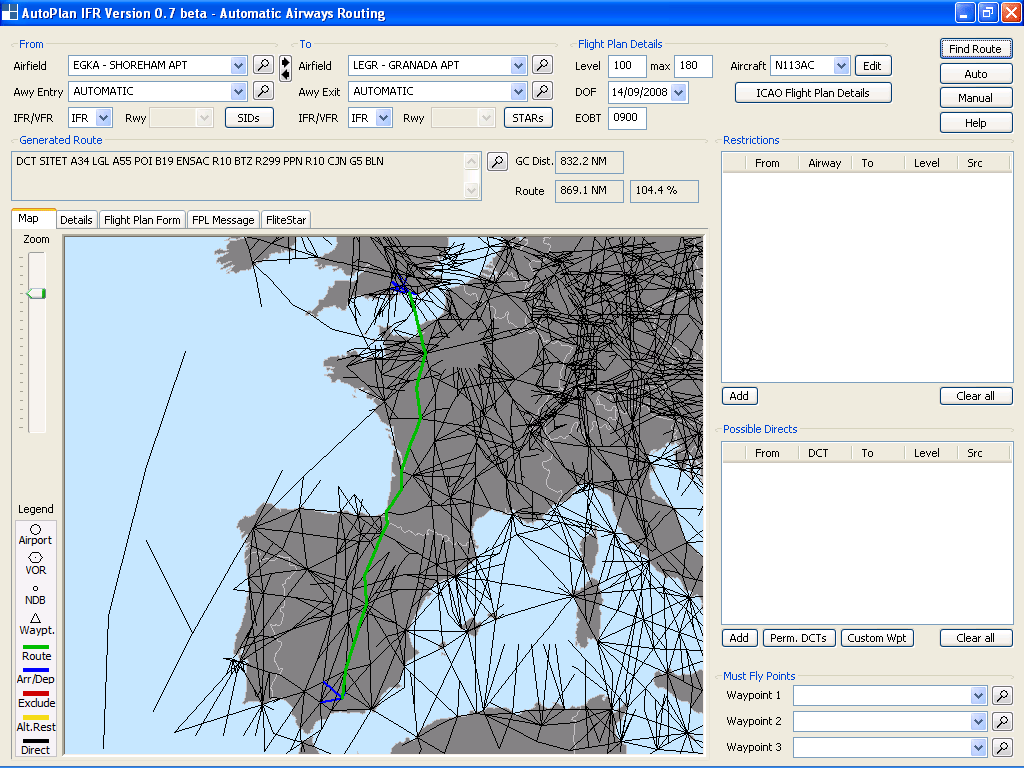
This program generates valid and usable lower airways routings for anywhere in Europe. The route is initially determined using a maze algorithm to find the shortest route through the airway maze and is then submitted to CFMU for validation. The resulting error messages are interpreted, appropriate exclusions or level changes are added, and the process is repeated as necessary. Most European routes are validated after just a few automatic iterations. Very occasionally, one needs to add an exclusion manually. The end result is validated for the actual date/time of the planned fight, which can be done up to 5 days ahead. This program reduces a sometimes horrendous process to a minute or two. I have so far tested it with every airways route I have ever done and it did them all very easily, with a trivial manual intervention in some cases.
Other Preflight Procedures
Flight plans are filed electronically, using either Homebriefing or the new UK NATS AFPEx facility. While AFPEx is free, it is available only to UK resident pilots and with a lengthy "security" login procedure, and is not generally suitable for usage while travelling because it forces a fresh download of its 5MB Java application which is infeasible if one is using GPRS/3G data or using an internet cafe computer. Either facility will however accept flight plans without geographical restrictions. Because Homebriefing costs about Euro 4 per flight plan, I tend to use AFPEx whenever I can get a fast low cost internet connection on my own computer, and save Homebriefing for the remaining situations.
Notams are obtained using the traditional UK NATS website. This is loved and loathed by UK pilots in similar measures but the fact is that it works just fine. I use the Narrow Route Briefing only and one simply pastes the airways route in there. With IFR flights, enroute situations (e.g. restricted areas due to airshows) are not normally an issue because Eurocontrol and ATC will make sure no airways traffic is routed where it should not go, but notams remain vital for airport information such as out of service instrument approaches and PPR requirements.
PPR (prior permission required) is a disease which is spreading through Europe and the rest of the world. The usual pretence is that the airport needs to "regulate apron capacity" - even if it is big enough to park the whole of its air force plus the air forces of its enemies. It is highly desirable to obtain a positive confirmation from each planned stop, using a form along the lines of this one.
I normally fax any airport before flying there, with standard questions e.g. do they need PPR; do they have avgas; costs, etc. This is a simple process which often turns up information which is totally wrong in the standard printed flight guides or flight planning software. In this case, Granada did not respond to 4 faxes (2 to ATC and 2 to AIS) and a phone call elicited a response that their fax machine cannot dial international calls! Nevertheless they were most helpful in confirming that Granada does not need prior notification.
Where you find the numbers to fax or - if you speak the language, or want to chance it using English - is another story! The official source is the national AIP. Most countries have their own websites and a list of these websites is here. There is also a general Eurocontrol website which is a bit of a pig to work out. Most of these need you to create a login/password for registration!! Other sources of numbers; much less reliable, are airport directories such as ACUKWIK or - a last resort - the databases which come with flight planning software already mentioned. Airports frequently change numbers without publishing the new ones. The ACUKWIK product is not too bad when it comes to numbers of handling agents who in turn can give you the current Airport Admin contacts. A final trick is to phone a nearby big airport and gradually work one's way up the food chain to its ATC (tower) staff who in turn is sure to have the current numbers for the ATC of other airports...
Weather
My usual sources for weather for IFR/airways trips are the MSLP charts in the first instance which are available up to 5 days ahead and show obvious features, the SigWx form which shows weather above FL100 (available about 18 hours ahead) and TAFs/METARs for departure, destination, alternate, and perhaps some airports along the route. For more short-term detail, this data is supplemented with weather radar, sferics and satellite images.
Airways flight in Europe has to be done at certain minimum altitudes (the airway MEAs) and if there is any cloud these altitudes would normally place the aircraft into cloud. Therefore, the general strategy for IFR flight is to climb until VMC on top is reached and stay there in the sunshine for the entire flight. Anything else results in an unpleasant and potentially turbulent flight with - especially over hours - a high chance of icing. Another risk in entering IMC when enroute is that one obviously cannot see ahead and a serious deterioation in the conditions cannot be detected until it gets bad enough to show up on a stormscope or - if you have one - radar. Therefore, the above weather sources are supplemented by more modern sources such as Meteoblue and NOAA which offer data on vertical cloud profiles, as well as offering longer range forecasts. However, the quality of cloud tops forecasting remains poor and one is doing well if the forecast is within a few thousand feet of reality! Some notes on cloud top data are here.
For this trip, for the day of departure (planned for 0800Z) the 0600 1200 MSLP charts showed a lack of fronts along the proposed route, which is always a good start, but also showed troughs in France. A sharp reader will notice that the 1200 MSLP chart has a preparation date/time which is much more than 6 hours older than the 0600 chart; this was due to a problem at the weather briefing company these came from. I did not worry about this much because I had other sources of weather information. The 0600 SigWx showed nothing of relevance at high level along the route, other than some stuff over the English Channel. A 1200 SigWx chart was not available, due to a similar problem to the other one.
The Icing Hazard charts for 0600 and 1200 did not show anything affecting the route. I occasionally look at these but don't think they mean a great deal. Obviously icing is a hazard only when flying in IMC which I don't do anyway when enroute, and my experience is that during a flight of some hours in IMC, at temperatures 0C to -15C, one is virtually certain to get at least some ice.
The MSLP charts showed a trough over western France and to get some idea of the conditions there I looked at the 0000 ascent (the most recent available) for Bordeaux which indeed showed IMC to around FL140. This was not a problem as the TB20 can go a lot higher. Other ascents for the rough area of the route were fine: Zaragoza Murcia Gibraltar. These ascents come from University of Cologne.
Finally, on the morning of the flight I got the TAFs and METARs which showed bad weather over western France and fine elsewhere. Plus the 0600 visible and infra red satellite images which suprisingly did not appear to show any significant cloud over the French portion of the route - weird!! Also on the morning of the flight, the weather radar and sferics 1 2 images did not show any heavy concentrated stuff over the French portion although they did show some lightning.
A day or so earlier I telephoned a professional forecaster who reckoned the IMC over the French bit of the route would be no higher than 8,000ft, with some scattered TCUs or CBs. His forecast was not very accurate - the organised IMC turned out to have tops around 19,000ft.
The wind forecast, obtained from various sources, suggested a relatively neutral crosswind over France, becoming a tailwind of around 10kt over Spain.
Based on this rather mixed bag of actuals and forecasts I decided to GO because
- departure weather was self evidently not a problem for climbing through;
- destination weather was obviously going to be fine;
- there was insufficient evidence suggesting organised cloud tops enroute would exceed the TB20 operating ceiling of 20,000ft.
The return flight weather was not examined because this was a 1-week holiday and one cannot get a meaningful forecast 1 week ahead.
Fuel Planning
This was particularly important on this trip, due to the long initial flight of nearly 900nm.
A great deal has been written on engine management but much of it appears overly complicated, and a lot that has been written is rubbish. The following notes do assume that you have the following instrumentation: a multicylinder engine monitor (e.g. the EDM700) and an accurate fuel flowmeter/totaliser (e.g. Shadin). Without these instruments there is simply no way to set up the engine properly, and one has to fly with generous margins which result in reduced range and the waste of a lot of fuel.
Every normal petrol burning engine delivers best efficiency (horsepower per fuel flow) around 25F LOP (lean of peak). The exact figure depends on the power setting etc but the efficiency curve is relatively flat in that region and therefore operating simply at peak EGT is nearly as good. At this point, called "stochiometric" combustion, there is an exact match between the number of hydrocarbon molecules being attached to oxygen molecules. Having too few hydrocarbon molecules (this is the LOP condition) simply means less power is generated. Having too many hydrocarbon molecules (this is the ROP - rich of peak - condition) results in unburnt fuel going out of the exhaust. Most modern car engines run at peak EGT all the time (except when cold, when the ECU enriches the mixture). However, aircraft engines of the type in the TB20 (Lycoming IO-540) cannot be run around peak EGT throughout their rated power range because their lightweight aircooled design prevents the resulting heat being dissipated at high power settings, or at low airflows (low aircraft speeds e.g. during climb). Contrary to pilot folklore, there is nothing actually "wrong" with these engine designs; power can come only from burning fuel and - at optimal cruise settings - they are nearly as efficient as the very best car engines. Most of the computer control technology used in modern car engines goes into delivering reasonable efficiency over a wide power output range; something not really relevant in an aircraft engine.
There is a widespread belief in GA that operating LOP yields huge efficiency improvements but despite the most careful tests I have not been able to replicate this. Flying at constant IAS and constant prop RPM (i.e. keeping thrust, airframe drag and prop efficiency all constant) there is a roughly 10% fuel saving between 75F ROP and peak EGT, but under 1% fuel saving between peak EGT and any LOP setting. What does make a big difference to MPG is flying slower!
During climb, which is done with all 3 levers fully forward (unless using the constant-EGT method - see below) the above thermal limitations prevent operation at peak EGT and the fuel injection servo is factory adjusted to deliver an operating point of about 150F ROP. This results in approximately 30% of the fuel remaining unburnt but the combustion is a lot cooler. Contrary to popular belief, it isn't the evaporation of the excess fuel that cools the combustion but rather the increased time from ignition to peak pressure plus slight decrease in produced power that generates the lower temperatures associated with excessively rich mixtures.
At cruise, below 75% of max rated power, the heat generated in the engine is lower and there is much more cooling, so one can run in the peak EGT region.
The highest power output (regardless of efficiency) is obtained around 100F ROP, for some reason. This is a useful concept for high altitude flight in a non-turbocharged aircraft; at say FL200 the engine is breathing little air, the corresponding stochiometric fuel flow is equally low, and the power output is low. The aircraft goes slower and slower and, at the ultimate operating ceiling, all it can achieve is a speed just above the stall. In this case, you want all power you can get and you aren't too bothered about fuel flow, so you set up 100F ROP.
Engine friction losses reduce at a lower RPM which is another factor one can play with when stretching things. Prop efficiency is more complex and I don't know anybody who understands it but I assume it does not change substantially between 2200-2575RPM which is the normal IO-540-C4D5D cruise range.
Another trick of lower RPM is that when LOP, the combustion takes place slower and because the magneto spark plug timing is fixed in crankshaft-angular terms, a lower RPM shifts the combustion pressure profile along in time, to a more appropriate position.
Finally, there seems to be a relationship between fuel efficiency and altitude, but this is difficult to quantify and experience with the TB20 suggests it is only very marginal. One argument is this: at the indicated airspeed that yields maximum no wind efficiency (typically close to but slightly higher than sea level Vy), altitude has no effect on airframe "efficiency" (i.e. distance/energy). In other words, the power required to maintain altitude at that IAS increases exactly in proportion to the increase in TAS. The contrary argument is that engine efficiency is clearly not constant over its power output, is poor at the very low power outputs one gets at say FL200, and the result is that the best "MPG" is obtained at around half the operating ceiling (i.e. about 10,000ft) for most non-turbocharged GA aircraft types. But, as stated, the penalty for climbing to a higher altitude (say 18,000ft) is very small - so long as the engine is operated LOP the whole time including climbs and descents.
The TB20 flight manual contains fuel consumption data but for some reason this was not generated from actual performance. The "best economy" values (which, one assumes but Socata have never clarified this, refer to peak-EGT operation) are 10-20% conservative. The reason may have been ignorance, or a desire to publish conservative data since the early TB20s did not have any engine instrumentation. To ease certification, Socata never changed the flight manual performance data and the latest (2002) TB20s went out with 1988 flight manuals.
It turns out that using optimal engine management a TB20 can fly for about 1300nm; some 20% further than the published data. This can be achieved using several combinations of RPM and fuel flow, but the best appears to be 10,000ft, wide open throttle, 2200RPM and 25F LOP. The fuel flow in this condition is 9.0GPH (US gallons/hr) which delivers a TAS of 140kt and, with 86.2 USG of usable fuel, gives a zero-fuel endurance of 9.3 hours. At 140kt TAS, 9.3 hours means a range of 1300nm. Suprisingly however, due to the "TAS gain" the MPG is only very slightly worse at 20,000ft.
The above ignores the higher climb fuel flow of course, but one recovers some of that loss during descent. The climb fuel consumption can be optimised by using the "constant EGT" method. Pick any cylinder, note its EGT shortly after takeoff, and then periodically lean a little to maintain that cylinder at the original EGT. This is more economical than climbing full-rich, and sidesteps the eventual need to lean anyway at high altitude. The constant EGT method enables a continuous best-power climb all the way to the aircraft's operating ceiling - neat!
And things get better at lower aircraft loadings; the lighter you are the faster it goes for the same fuel flow, and even if you take off at MTOW this gradually improves due to the fuel being burnt off. However, the effects of loading is another TB20 mystery. I have very often noticed that the takeoff weight seems to have no effect on the IAS at a given power setting. I think the only explanation for this is that the only practical way to increase the loading in the TB20 is by carrying passengers in the back, which moves the CofG to the rear, and this reduces the elevator drag.
The result of all this is that 1300nm is a practically achievable zero-fuel range and I have proved this over many flights, by setting a specific engine operating point and watching the speed and fuel flow. Accurate instrumentation, whose accuracy is regularly verified, is obviously required.
Unfortunately it is impossible to do the above leaning procedure simply by setting up some fuel flow etc numbers. On the first flight on this trip, air temperature varied from -20C (FL190, France) to +11C (FL090, Spain) and this represents a big change in air density, requiring correspondingly different fuel flows - even if the MP remained constant. Even avgas varies in density: it expands 0.1% per degC so the density difference between fuel loaded from a bowser sitting in Spanish sunshine at +30C, and cooling to -20C, is 5%. The turbine based fuel flowmeter measures volume flow, but combustion works on mass flow. Therefore, for optimum economy, one needs to re-set the desired operating point (say 25F LOP) at different phases of the flight.
Fuel planning has to include alternates. One should plan two alternates: a "weather alternate" (which is taken if the destination weather is no good) and a "crash alternate" (which is taken if somebody has crashed on the destination runway and closed the airport). Obviously, while the latter can be right next door to the destination, the former cannot since its weather is likely to be the same! However, a weather alternate can be next door if it is e.g. an airport with an ILS but with a £100 landing fee which you are trying to avoid by going to an airport which has no instrument approach - etc!
The whole subject of alternates is made more complicated by a general shortage of airports in Europe which have Customs, have avgas, and accept GA traffic. In some parts - Greece comes to mind - one may have to file a military airport (normally closed to GA) as an alternate, and alternates with no avgas (at which one would be stranded if one actually went there, and would have to ship in avgas in drums to get out again) are more common than that. It is also true that most alternates are places you do not actually want to go to; many are absolute dumps. I normally avoid this kind of stretched planning.
Conventionally, a pilot is trained to proceed to the destination and if this proves no good, he proceeds to the alternate. Under FAA IFR rules, one needs enough fuel to fly to the alternate, plus 45 minutes at cruise speed. This is OK for a B737 doing 500kt but 45 mins does not get you far at 140kt, if there is widespread bad weather. I therefore plan a reserve of at least 2 hours after the alternate and this is more realistic given the often poor choice of alternates.
Nowadays I have satellite internet access in the cockpit and can get weather data during flight
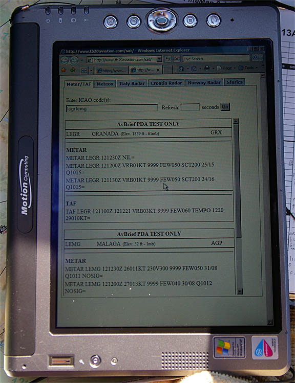
This allows diversions to be planned well ahead, enabling more intelligent choices to be made. More details of the equipment are here. The above display device is an LS800 tablet computer which normally sits somewhere to hand, running VFR charts under Oziexplorer; this is a useful emergency function for e.g. an engine failure above an overcast because one can see the nature of the terrain below. I have both VFR aviation and 1:50k topographic charts for most of Europe.
This flight had an airways distance of 869nm. Working at the previously established 10,000ft performance of 140kt TAS and 9.0GPH, the calculated airborne time was therefore 6.2 hours, and the fuel requirement (ignoring the climb and descent phases) was 55.8USG, leaving a reserve at destination of 30.4USG. The alternate, Malaga, was about 40nm further and the 30USG reserve was thus sufficient for at least another 2 hours after that. While there was plenty of leeway here, this calculation does make some assumptions e.g. no headwind. To some extent therefore, one was going to rely on the very accurate on-board fuel flowmeter / GPS system which calculates a continuously updated "fuel at destination" value.
The Flight
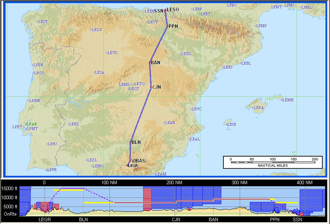
The outbound routing was:
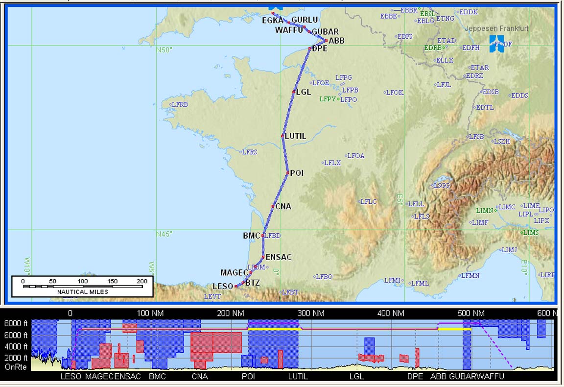
EGKA SITET A34 LGL A55 POI B19 ENSAC R10 BTZ R299 PPN R10 CJN G5 BLN LEGR
FL100
Alternate: Malaga LEMG
Distance: 832nm (GC); 869nm (airways)
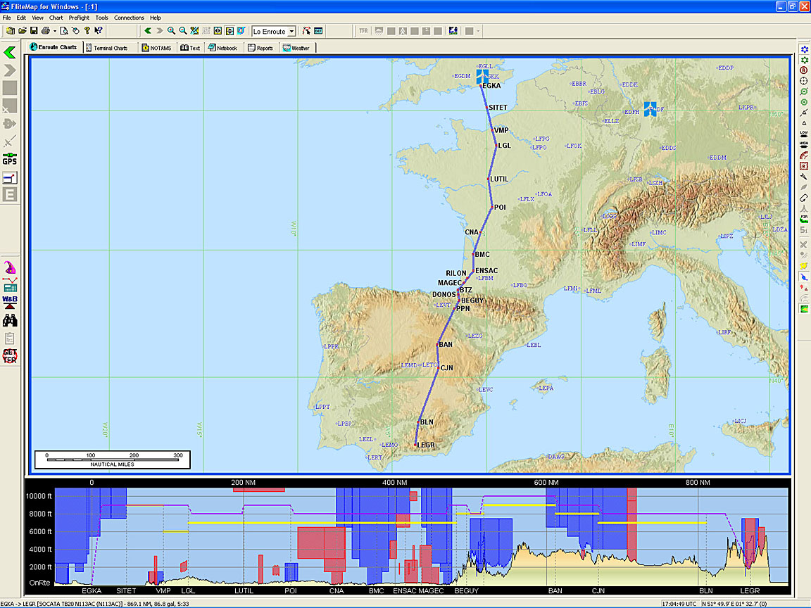
Note: the Eurocontrol routings given here and elsewhere will most likely not work by the time you might try them because the precise form needed to get the route into the computer changes from one week to the next, and there are frequent differences between weekdays and weekends which are largely due to a lack of military activity on weekends.
Beware: the terrain profile shown in the route illustrations (e.g. the one above) is not accurate. The Jeppesen Flitestar software contains large elevation errors. Also, the flight level shown in the profile diagram does not relate to the flight; filed or actual.
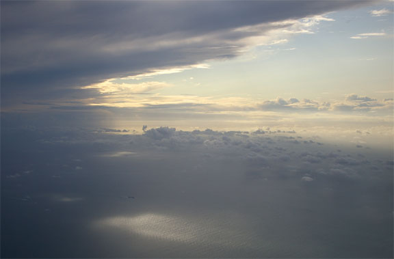
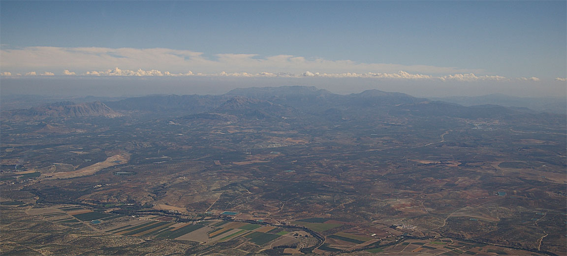
The weather conditions started pretty good, but it was immediately clear that the SigWx prediction of high cloud over the Channel was going to be borne out - rare as this seems...
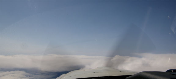
Things got more interesting after that, with tops to FL160 which had to be climbed over

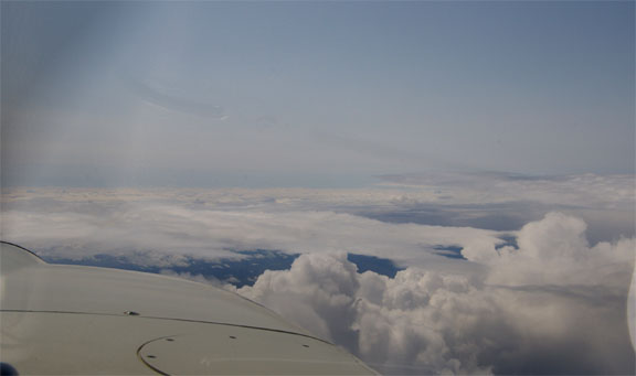
As soon as the French coast was reached, the high cloud vanished, to be replaced with a reasonably smooth overcast at about FL120, and I descended to FL130 hoping this would be it, and I could do my best fuel management

It didn't last long... Soon I had to climb again

to stay above the muck. Paradoxically it was scattered/broken and ground was always visible throughout the entire flight, so it could be argued that a low level flight would have been better. The problem with that strategy is that one can get snookered between a lowering cloudbase / rising terrain and the only way is UP, through the clouds, which brings the risk of icing and a possible reduction in climb performance bad enough to not ever reach the top. Remaining on top at all cost is the only way! This consideration would have also prevented this flight to have been done under VFR - one would have got as far as the Pyrenees.
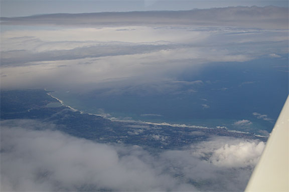
By ENSAC I was at FL190 and only just remaining above the general layer
This was not exactly forecast and curiously nothing in the 0600 satellite images (visible or IR) suggested it, so it must have formed in the last few hours. The TB20 will do FL200 and I have done that previously, and I had an oxygen bottle which was big enough to not worry about getting used up, but I did not want to waste fuel. There was a lot of much higher cloud - plenty of TCUs to at least FL250/300 - so a lot of heading changes were required. I have never done as much zig-zagging on any IFR flight before. A picture of the actual track flown (as recorded in Oziexplorer running on the LS800) is here.
An additional problem was an almost constant headwind of about 10kt. The forecast was an almost pure crosswind initially, changing to a tailwind in Spain as one passed around the eastern part of the high pressure area (wind flows clockwise around a high pressure area, in the northern hemisphere).
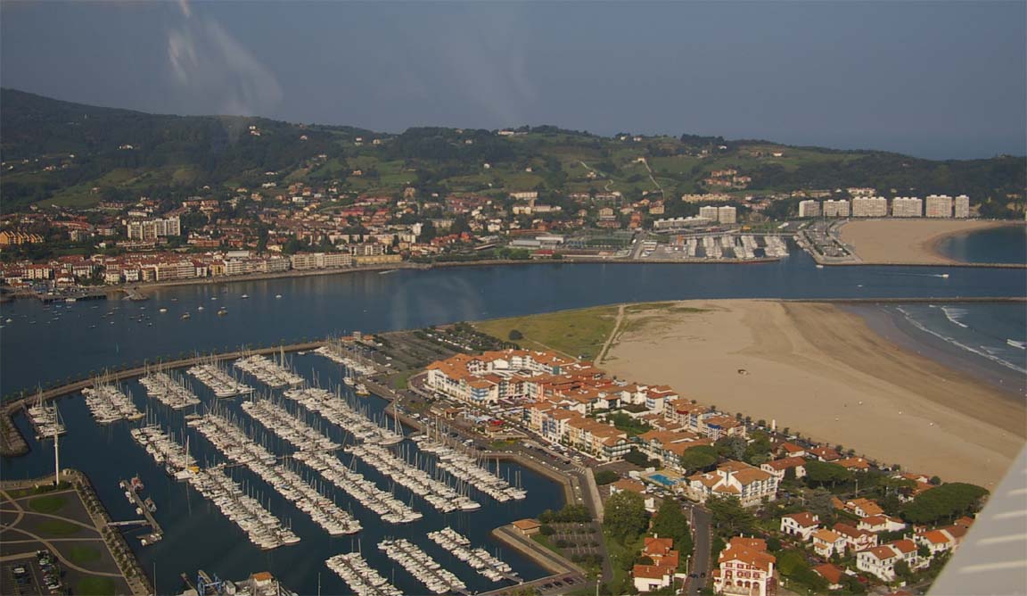
By Biarritz (BTZ) things started to improve
with Biarritz being visible through a hole
The computed FOB (fuel on board) at destination came close to a level at which I would have had to stop for fuel - the GPS image below shows me doing some silly heading to avoid yet another large cloud
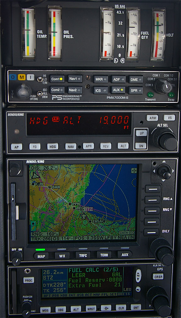
and the KLN94 above shows it (the "Extra Fuel" figure for LEGR) reaching 21USG at this point. This was right on the margin (destination, then alternate, then 2 hours at cruise speed) with which I would be prepared to continue nonstop to Granada.
However, in Spain, matters improved rapidly
and I descended from FL190 to FL120 in several steps - ATC did not allow it to be done in a single step - but I managed a more or less continuous -300fpm descent, which recovered a lot of energy lost in the climbs. The headwind also finally changed to the forecast tailwind, of about 10kt.
The crucial decision point for whether to do a fuel stop was planned to be near Zaragoza. This is a well organised airport where a policeman turns up in a car to check your passport at the aircraft and a bowser turns up equally fast. Approaching this point, I had 44USG in the tanks (slightly over half; total usable TB20 fuel capacity is 86.2USG) and the FOB (fuel on board) at the destination calculated by the flow computer (linked to the GPS) was 27USG which amounts to a reserve at the destination of about 3 hours at cruise. So I decided to continue to Granada. There was no way I was going to use up half the tanks in the remaining bit of the flight; about 1/3, especially given the wind change, the lower cruise level being more efficient, and the considerable amount of free energy to be recovered from a descent. Had something gone badly wrong (e.g. a 50kt headwind; not sure where that could have come from on the day...) there were other options to divert to.
I got an ATC shortcut to ANZAN; about 200nm in one leg.
Madrid Control asked to verify the aircraft type; they could not believe that a TB20 was doing such a long trip... at the end, the ATCO wished me a good flight and "good tailwind".
The tailwind later dropped off and in the last 100nm or so changed to another 10kt headwind but it was much too late for it to make any difference to reserves because we were motoring along at about 150kt TAS.
Northern Spain is quite barren but the land becomes greener further south
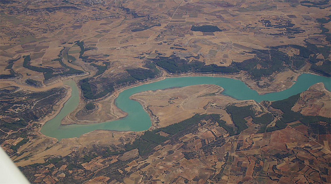
and greener, with a lot of lakes

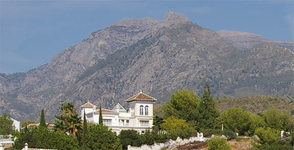
The Sierra Nevada mountains appeared in the haze, about 200nm away
Finally, there were a few last hills to clear - these were only about 4000ft high and the last 100nm was flown at 9000ft
Spanish ATC use a mixture of FL090 and 9,000ft - it seems that they work in feet when over certain military areas.
One normally flies with fuel tanks balanced or, if flying alone, with the left tank substantially emptier than the right tank. However, when flying close to the fuel limit, one needs to be careful to avoid a tank running dry at an inconvenient moment! The TB20 has very accurate fuel gauges but even so, with about 80nm to run, I decided to run down one fuel tank as far as possible, so the last bit of the flight would be done using the other fuel tank whose contents would then be something close to the remaining fuel calculated by the flow computer. Some experts, including John Deakin (of Avweb) recommend running one tank completely dry i.e. until the engine stops, claiming this to be safe because of the certification requirement for the engine to restart within something like 10-20 seconds of switching to the other tank, but I did not want to risk this especially over the barren Spanish terrain, so I ran down the left tank until the Low Fuel warning light came on which happens at the 10USG point (1/4 full). At this point the right tank was half full which, with about 30nm left to run, was perfect.
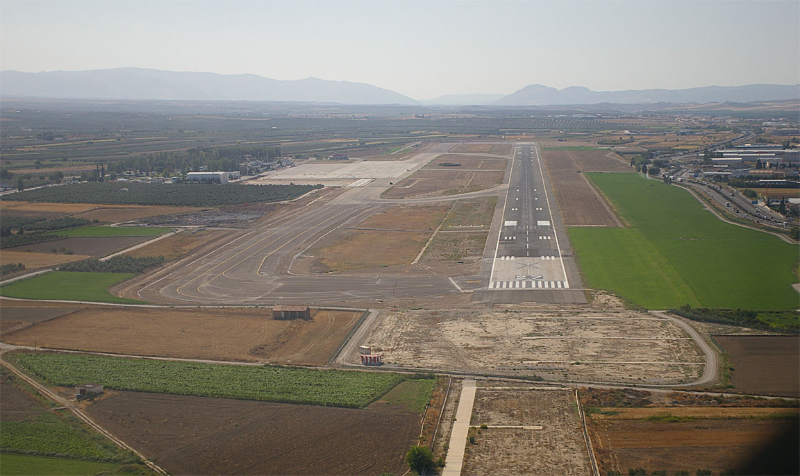
Granada is surrounded by serious terrain and I was planning on flying the BLN 1D STAR (the only one which connected to my filed route which terminated at BLN) followed by the rather long LOC approach to runway 09. ATC had about an hour earlier advised that Granada was on 09. Notams showed that 09 ILS was out of service but actually only the glideslope was out of service.
I did indeed get the BLN 1D STAR but Granada ATC advised that the wind had changed and was now 270/07G13 and offered either a downwind landing on the massive ~3000m runway, or the 09 LOC approach followed by a RH circle to land on 27. I said I would take the downwind landing. However, having flown the STAR and with about 10nm to run to the VOR, they asked if I would accept a visual approach, downwind join, RH circuit to land. I accepted this as the conditions were fully visual and the runway could be seen from many miles away; it also knocked at least 20nm from the remaining distance. The resulting steep descent from 9000ft to about 2900ft was fun, with the gear down to help the descent. The following pic shows the airport above the centre of the cowling
I did not want to fly too far over the built-up area to the east of the airport so flew a steep - almost a glide - approach to the runway
The only traffic was a GA aircraft departing IFR to Morocco. Granada gets a dozen or so 737s daily but remains totally laid back.
The airport has a massive concrete apron and an apron extension was being built. There were a dozen or so GA aircraft parked; several knackered Cessnas with flat tyres which seemed to have been there for years, a Cirrus SR22 and a Piper Meridian. I could not help observing that the only apparently airworthy examples were all N-reg...
I got a FOLLOW ME truck to parking - all very easy. Avgas turned up within minutes. The price was Euro 2.30/litre. I tried my "commercial" trick which used to work in Spain until recently but I don't think this works anymore; the bowser driver asked to see a "commercial flight certificate" (not an AOC as such, suprisingly). However, the price for a commercial flight was Euro 1.70/litre - nothing like the 50% saving one used to get by using an AIR BP fuel card with a limited company name on it. Anyway, they did not take the AIR BP card - only Visa or, presumably, cash.
The post-landing FOB value was 23.4USG. The fill was therefore calculated at 237.4 litres. The bowser put in 238 litres which (assuming it was 238.0 which I doubt since the pump did not show a decimal point) corresponds to an error of 0.25% - not bad after a flight of 6 hours 50 minutes!!
23.4USG is about 7USG worse than the originally calculated reserve fuel - this was the cost of all that climbing and zigzagging, plus the headwind along most of the flight.
The MTOW of a TB20 is 1400kg. On this flight, the takeoff weight was approximately 1305kg and 171kg of fuel was used on the flight. I do not have the exact track distance actually flown - the airways route is 869nm - but the above translates to approximately 19 UK MPG.
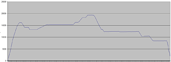
The altitude plot of this flight is below. The climb rates of the steps to 19,000ft are approximately +200fpm.
There is no bus - you walk to the terminal, to the GA office which is found by following the signs marked "C"; some stairs lead upstairs. The staff were most helpful although only one could speak English. There was nothing to do, though they telephoned Zaragoza (my next planned stop) with my details to check if we could fly there; the reply was it was OK but they wanted a fax with the usual details.
Getting out of the airport was easy enough. We picked up a hire car - the wait for the car rental staff to come back from a siesta was far longer than refuelling the aircraft and everything else. I would strongly recommend against getting a car - unless substantial trips out of town are planned - as Granada is difficult to drive around due to lengthy one-way detours; the Spanish drivers are also very aggressive and you get no leeway at any time.
Granada
Granada is a very historic city, with countless spectacular sights. It is almost surrounded by mountains, with the Sierra Nevada to the south.
As is normal in the old Spanish cities, a lot of shops close over lunch and stay open till around 10-11pm in the evenings. There is a lot of social life, with whole families including small children being out and having fun - very different from England!
Granada has a university, a lively student population and a very active hippie scene, with plenty of bars where almost anything can be smoked...
We stayed in the Vincci hotel which was walkable to the rest of the city and the room was good value. It had parking facilities (Euro 14/day) and someone would park and fetch the car which was nice because parking in Granada is a nightmare. However, as is increasingly common these days, the cost of internet (wifi) was exorbitant at nearly Euro 20/day so I used a combination of my ultra pricey Vodafone 3G facility and an excellent internet cafe near the Elvira Gate which was just Euro 1.80/hr.
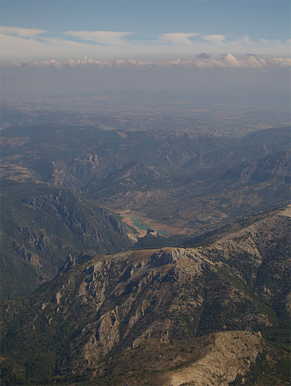
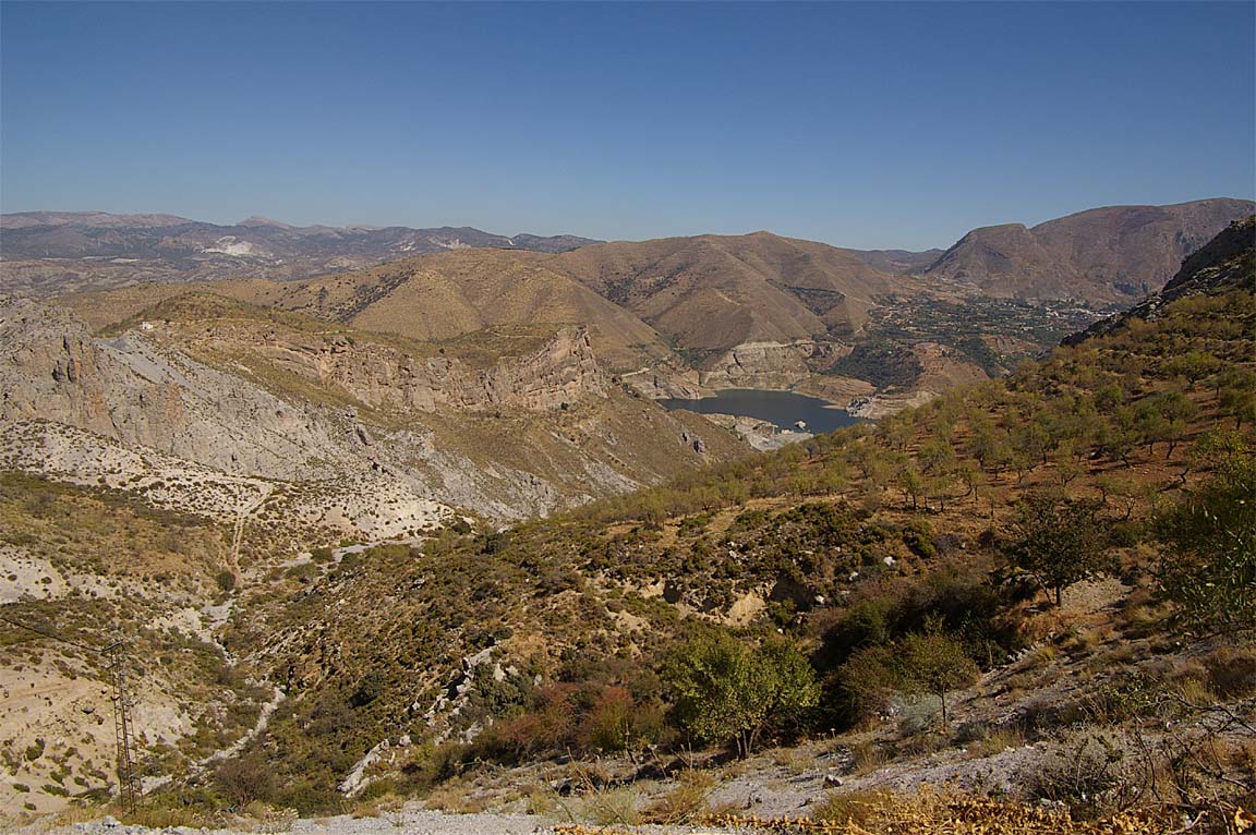
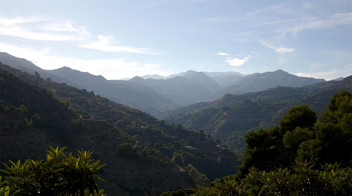
We took a drive to the mountains, which are very near. It is a very winding but excellent quality road (A395, mainly) which climbs to around 8000ft, and it provides some great views
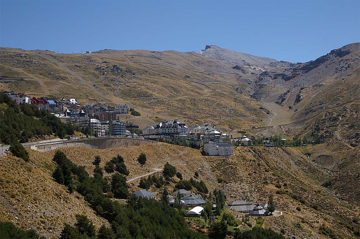
Eventually it leads to a rather deserted skiing complex
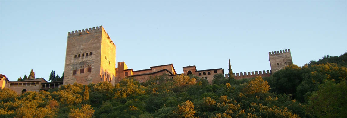
We visited the famous Alhambra; a mainly 14th century palace which is a World Heritage Site. Due to its location it is impossible to get a pic of the whole complex, short of climbing a far away hill or getting airborne - this one was taken from the city below
The Alhambra is definitely well worth a visit but you must either book tickets over the internet (which at this time was not possible for less than a week or so ahead) or turn up as early as possible - 7:30am is recommended. The queuing was badly organised, with a huge queue at the ticket office but with a row of credit-card-only ticket machines being largely unused. The ticket office sells around 2000 tickets each day to people who turn up, plus another 4000 online and to various agents (hotels etc). If you just turn up, you need to be among the first 2000 to get a ticket. The ticket is timed and you have to get into one part of the palace within a 30 minute slot.
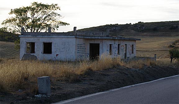
We did a day trip to the south coast, to meet up with friends who live near the town of Nerja. This is a lovely town close to the beach. I think my last English plumber (the one who never turned up) now lives in abject poverty in this little house
The winding road over the mountains (A4050) provides many spectacular views and has been mostly resurfaced
but is very slow and the service stations are only marginally better than those on the M25
Fortunately, due to the recently built motorways it is virtually devoid of traffic - with the exception of some trucks that occasionally end up on the wrong side of the road! I would absolutely not recommend this road if there is the slightest chance of snow or ice.
The food at Granada was universally excellent although I personally prefer Greek food. There were countless tea shops serving every imaginable brew.
Unfortunately only a minority of the Spanish people we met could be described as friendly. This was also evident on previous trips to the inland parts of Spain; e.g. the Zaragoza trip, but is much less the case on the southern coast despite the latter being totally overrun with British builders and plumbers, and San Sebastian (on the border with France) was also totally different.
The Return Route
This was to be in two parts: Granada-Zaragoza, and Zaragoza-Shoreham. This was done partly because we wanted to have a look at Zaragoza, and partly to avoid returning to the UK with relatively minimal fuel. The UK often has poor weather, Shoreham has a poor (NDB-only) instrument approach, and the combination results in a high probability of having to divert, so it is not wise to mess around with fuel.
Unfortunately we got shafted by Zaragoza...
2 days before the start of the trip, I had faxed them (correct # and confirmation of transmission obtained) with the usual information re PPR. This is my normal procedure: before any trip like this, I fax all airports with the usual details and ask them if there is anything special I need to do, and say it is fine to hand-write the reply on the piece of paper and fax it back. They never replied to this fax. I have since investigated this and they have refused to say whether they got it or not.
On the day of my arrival at Granada, the airport OPS man phoned Zaragoza to check they don't need PPR, and to check it would be OK for me to land and park there on the planned date 5 days later. They apparently didn't need PPR but wanted a fax the day before with the usual details.
On the day before departure to Zaragoza, I sent them another fax (confirmation of transmission obtained) with the details, to their published ARO fax # of 0034 976 780624 (which had a working fax machine on it, and I also used it to communicate with them on my last trip Nov 2007) and this fax contained a fax # (fax2email so always working) and an email address, and I asked them to let me know if there were any problems. I also filed the IFR flight plan that evening. They have since said they got this fax and tried to email but found the email was not sending (which was true, due to a temporary server issue at my end) but despite knowing the email was not working they did not try to fax me back, and would not discuss why not.
I heard nothing - not on the morning of departure, not ever. I have since found another fax # for Zaragoza: 0034 976 712412 but have no idea whether it works. Airports which actually refuse landing permissions unless some PPR requirement is met have a duty to be contactable using published data - a concept which is unfortunately wasted on many of them. But in this case it is clear they had one and almost certainly both faxes. They also had the flight plan, of course...
The Zaragoza notams showed nothing of relevance and no mention of PPR or any restrictions.
On the morning of departure to Zaragoza, I went upstairs to pay the landing and 5 nights' parking (very cheap at Euro 20) and the OPS man told me that he had just a few minutes before got a message from Zaragoza saying I could land for fuel but parking would not be allowed. He showed me the message sent by Zaragoza over the AFTN - it just said "not authorised" with no reason given.
The easy option was to fly to the alternate: Pamplona. This has avgas, according to published data. I pressed the van driver to call his boss and actually telephone Pamplona to check this. He came back saying Pamplona has no avgas.... I have since made some phone calls - the published phone # for Pamplona is duff - and after some struggle and slowly dictating alpha..victor..golf..alpha..sierra several times (no English speakers anywhere) established that they "probably" don't have avgas.
So we decided to stop at Zaragoza just for fuel and continue to the UK, weather permitting.
Just before we started up, a man in a van turned up to say that the flight plan has been cancelled by Zaragoza and they would not allow our flight at all - not even to refuel.
This behaviour at Zaragoza was disgraceful.
The Spanish AIP contains this:
AIP SPAIN AD 2 LEZG 1 AERODROME GEOGRAPHICAL DATA AND ADMINISTRATION
Remarks (2) IFR/VFR general aviation traffic is conditioned to the apron capacity.
They must request SLOT PPR 3 HR to LEZG CEOPS vía TEL *34 976. 712.304
FAX * 34 976. 780624 o AFTN LEZGZPZX . Aircraft type, registration number, operator,
departure and destination aerodrmoe an EOBT , ETA and ETD must be included in
the request. Traffic without authorization will not be allowed.
The lesson here is to treat Spain like Italy and never fly to any airport until PPR and avgas have been positively verified, either by getting a fax reply, or with a phone call. A native speaker is likely to be needed; the best way to sort that is to collect the phone number of someone at the departure airport office who can make the call on your behalf.
Later, I did establish email communications with someone in the Spanish CAA, possibly based at Zaragoza, who sternly pointed to the AIP entry above. However, this communication came to an abrupt end when I emailed him copies of the faxes sent to Zaragoza advising flight details and requesting PPR, including the fax transmission receipts, and asked what happened to these faxes... no reply was ever received after that.
Replanning IFR flights for different destinations in a hurry is a considerable hassle because - without a printer which I do have but did not bring, and anyway it is not battery powered so can't be used around the aircraft - one doesn't have the printed plogs, approach charts, enroute airway charts... While it is quite possible to hack it by copying out some of the stuff onto paper and loading the waypoints into the GPS (perhaps after getting airborne, having entered the first few waypoints only on the ground), and relying on electronic devices such as my LS800 tablet computer running Jeppview, and I have done this a fair few times, I don't really like doing it. The new Autoplan program makes the route planning trivial but there is still a lot of work to do.
So we decided to fly to San Sebastian, where we have been before and really liked, and stay there for a couple of days instead of Zaragoza. The helpful Granada OPS dept offered to refile the flight plan, which they did and gave me the new routing, but when I called up the tower to get the departure clearance they said the flight plan was refused because one of the waypoints would not be acceptable. This was not very suprising since I had by then used Autoplan to check what kind of routing might work, and it was nothing like the one they gave me... So, in the cockpit with a laptop on my lap
I worked out a new routing and filed it over the internet using the 3G-capable laptop - this time using Homebriefing (which I subscribe to; Euro 37/year for 10 flight plans) because AFPEx is useless in any mobile situation.
The weather was checked and it was OK for the first leg at least. The TAFs/METARs were OK. The 1200 MSLP showed no frontal activity. The 1200 SigWx showed nothing of relevance at altitude.
Granada-San Sebastian
The routing was
LEGR VIBAS B112 BLN G5 CJN R10 SSN LESO
FL100
Alternate: Biarritz LFBZ
Distance: 381nm (GC); 392nm (airways)
Despite the logical SID which connects to the filed route (which starts at VIBAS) is one of the two VIBAS ones, Granada tower gave me the BLN 1N one. Oh well... Off we went.
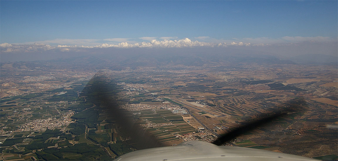
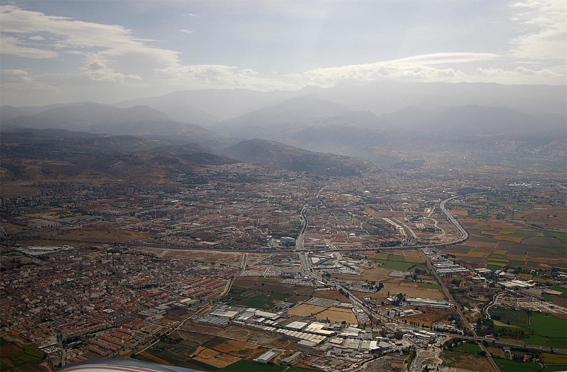
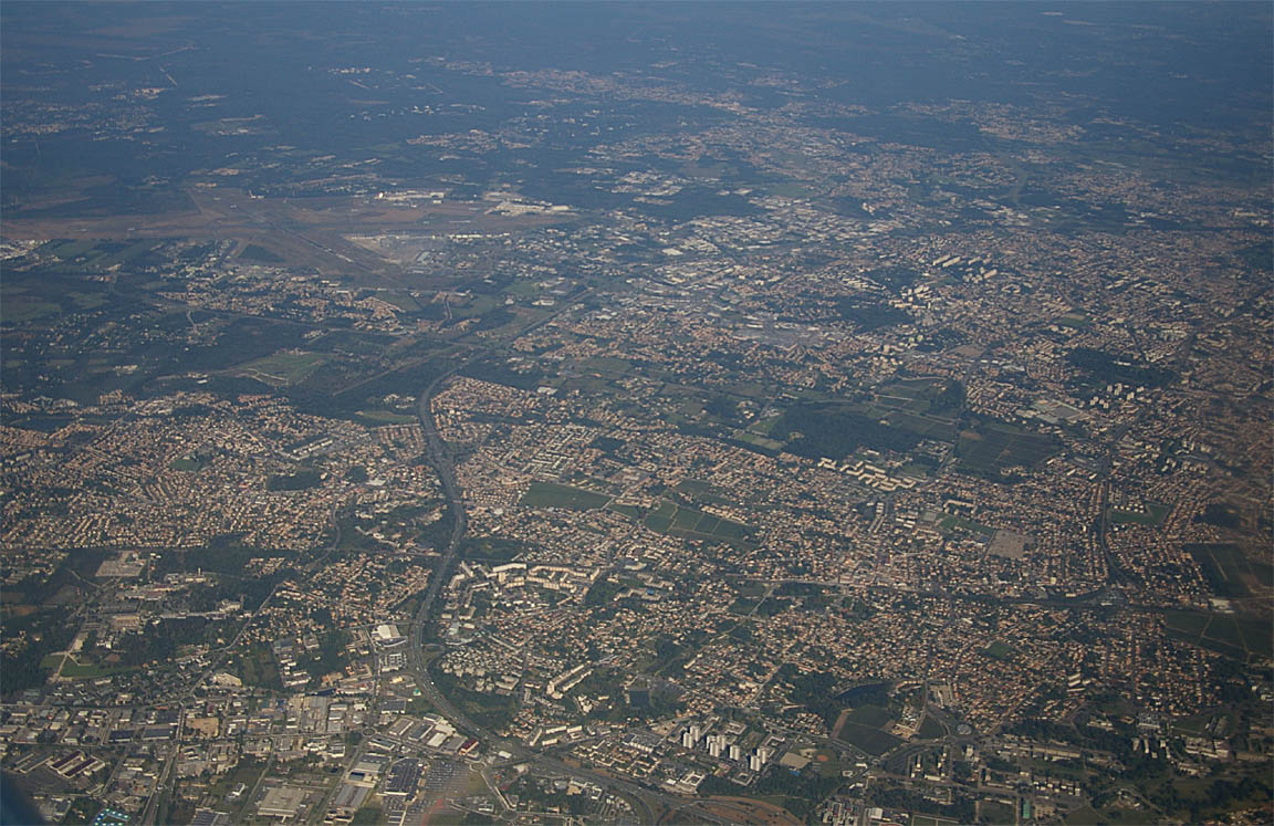
Granada has a lot of suburbs spread out all over
The weather turned out to be very different from the forecasts and, as is often the case for vertical cloud extent, the SigWx turned out to be meaningless as an indicator of cloud. There was extensive cloud cover over much of eastern Spain to ~ FL250, and some isolated stormscope returns. We climbed to FL170-180 to remain on top but could not climb higher, presumably due to descending air which could have been a mild "mountain wave" - we were ~ 14,000ft above the terrain and the wind at our level was just 20kt. Temperature was -11C which is also substantially warmer than standard. It was doubtless correct to keep out of the cloud layer since a lot of it quite dark and full of water, so would have resulted in airframe icing.
Note: the SigWx form does not forecast vertical cloud extent; the vertical extents of the scalloped areas apply to the icing or turbulence only !!
The service from Madrid (on 124.87, around 1100-1200Z) was appalling and the worst I have ever come across under IFR. Repeated calls for climbs or heading changes "due weather" were ignored. She could obviously hear me though. At one point I said "is anybody there???" but again got no reply. We managed OK but it was a right hassle. Any worse and I would have made a PAN call and just got on with it. Unfortunately, it is known that many ATCOs around Europe cannot speak English - beyond the stock phrases e.g. "cleared for the ILS" - and they simply ignore the caller if they cannot understand.
We remained at high level till about 30nm before the destination and then did a steep descent to the VOR approach for runway 22. Biarritz provided a radar service until established on the VOR inbound, and allowed the descent to be substantially extended over the sea, in order to lose the altitude.
About 2mm of ice was picked up in the descent but as the 0C level was about FL100, and the terrain ~ 2000ft, this was immaterial.
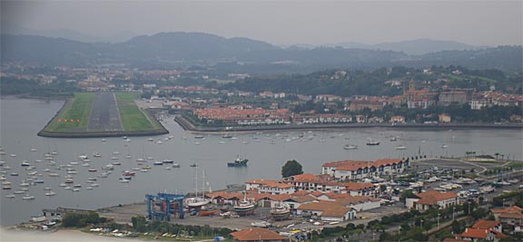
San Sebastian airport is a small informal place which has some scheduled turboprop and light jet traffic
and there was zero delay in getting out. Everyone was very friendly; the fuel man kindly drove me to his hut to pay and then drove me back to the aircraft. Payment is possible with Visa or cash; my AIR BP card was not accepted anywhere on this trip. We ended up parked next to a TB20 belonging to the French DGAC!!
Due to some exhibition in the city, a lot of the hotels were booked up. We found a lovely apartment close to the beach called Hostal Alemana (tel 0034 943 462544 fax 0034 943 461771) which was all new inside, had a nice room, nice staff, and free wifi.
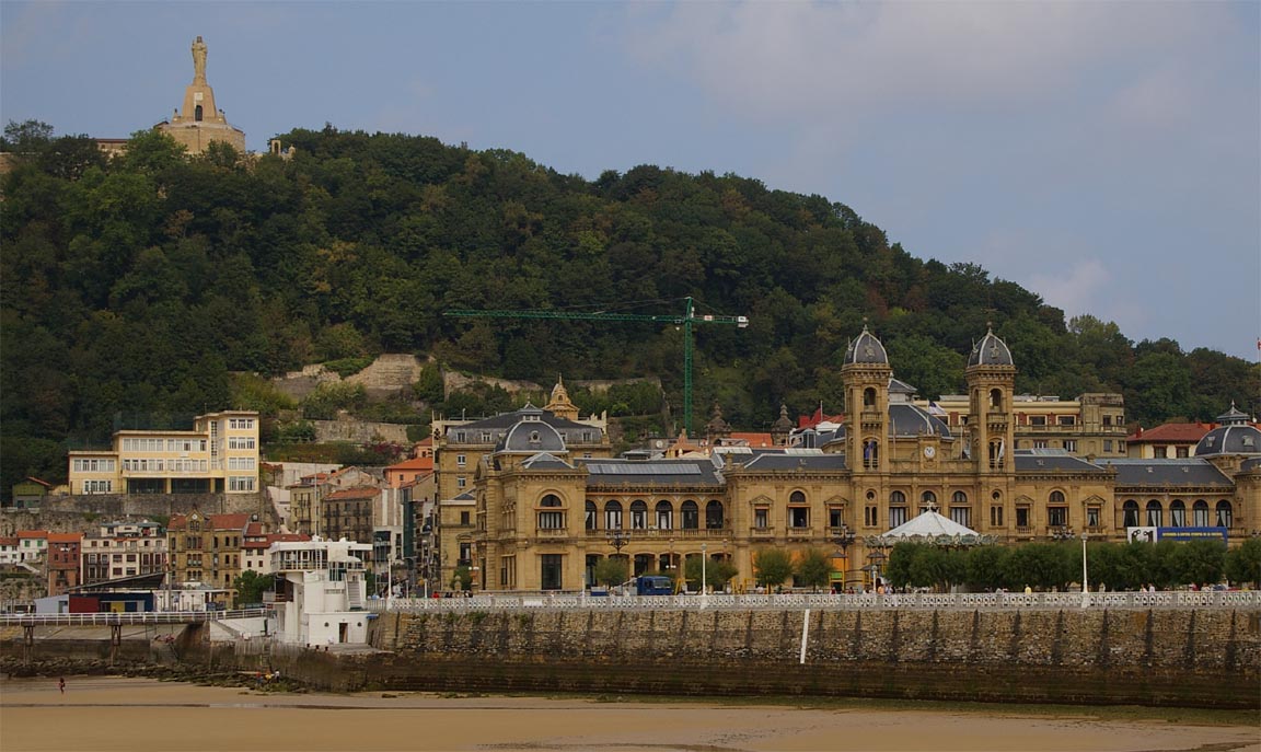
San Sebastian is a lovely old city with a long beach, lots of bars, interesting architecture
and lots of outdoor life. It is a long way from Granada in attitudes - practically everybody was most friendly. The city has super aquarium with one of the best restaurants ever on top of it, and very much else...
Not that this is my area of speciality but there was a good number of shops selling equipment for growing cannabis

Food was universally excellent
We had one whole day there but really needed several to have a good look around, despite having done a previous trip there.
San Sebastian-Shoreham
The routing was
LEZG BTZ R10 ENSAC B19 POI A55 LGL H20 DPE R50 ABB T27 GURLU Y8 WAFFU EGKA
FL100
Alternate: Bournemouth EGHH
Distance: 452nm (GC); 553nm (airways)
Looking at the above, it is pretty obvious that one would ask for a shortcut from LGL onwards... The DPE/ABB/GUBAR nonsense is an artefact of the shortage of north-direction airways in that area, but ATC normally let you go.
On the day of the flight a potential spanner dropped into the plan in the form of a notam of an airshow nearby. I phoned them up - "no problem".
The MSLP showed no frontal activity. The SigWx showed nothing significant at high level. TAFs and METARs showed nothing significant for anywhere near the time of the flight. The Form 414 showed a ~ 15-20kt headwind for most of the route. One rarely sees a better weather picture but unfortunately the forecasters can easily get the higher altitude part of it quite wrong. In this case, there was the option of hacking it below the 0C level but above the French airway MEAs which are mostly around FL070.
In the departure clearance, San Sebastian suprisingly would not give me one of their SIDs; just a squawk and a climb to 5000ft to BTZ. I got handed to Biarritz Approach who took over immediately and gave me a climb to FL100, and after that it was one long run all the way to Shoreham.
The departure from runway 04 takes one past the San Sebastian marina
There was a fair amount of haze but at FL100 we were above it and the Pyrenees were soon disappearing in the distance

Bordeaux went by an hour or so later
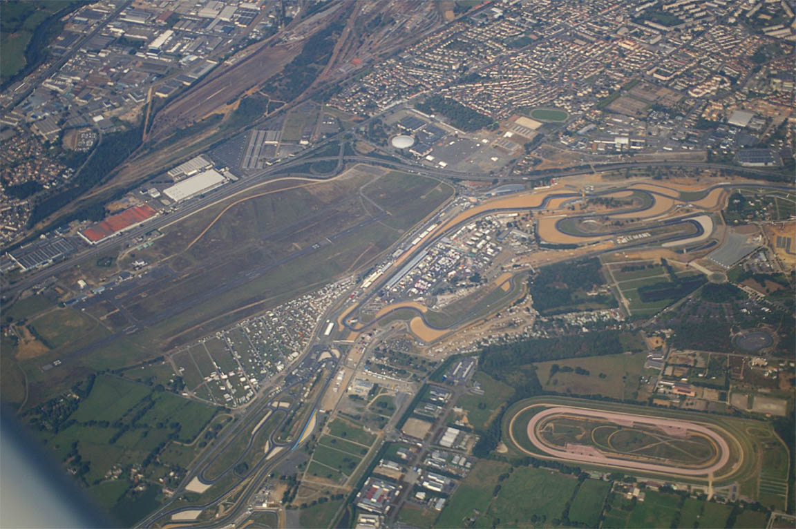
to be followed by Le Mans another hour or so later
The weather was near perfect, with just a lot of haze below the operating level.
I asked for and got the expected shortcut from LGL to SITET (effectively a DCT to Shoreham) although they had to transfer me to Paris Control for it. This took a massive chunk out of the route.
About an hour before arrival at Shoreham, the crap Honeywell KFC225 autopilot packed up again, with the same burning smell which I got from the failure on the Zaragoza trip. Some notes on this piece of junk are here. When it works it is excellent in performance and functionality but there is a basic design defect in the servos. I pulled the three autopilot system circuit breakers and the smell disappeared (as it did last time) and I flew on by hand. I already have a complete set of spare servos so can get it sorted fast. The one which burnt out is a KS270C pitch servo and is still under its 6-month warranty because it packed up a few months ago. Fortunately, as described in the last link above, this failure led to the discovery that some or possibly all of the autopilot failures have been caused by radio frequency interference from ground sources.
Apart from the autopilot failure, the entire trip was uneventful.
Other than jet contrails at high levels, no other aircraft were seen anywhere enroute, and no obvious GA traffic was heard on the airways sector frequencies. So much for the "crowded" European airspace. This is common on IFR flights around Europe as there is little or nothing flying enroute below FL200. The entire trip was uneventful, with no significant turbulence at any time.
Total IMC time on this trip was around 10 minutes - the descent into San Sebastian. This demonstrates how an IR enables one to avoid bad weather. Many pilots believe that an IR is used to fly in cloud but nothing could be further from the truth.
Airborne times were:
EGKA-LEGR 6:50hrs
LEGR-LESO 2:45hrs
LESO-EGKA 3:35hrs
Fuel prices ranged between Euro 1.70 and 2.30 per litre. This is a massive increase from the previous year.
Spanish airports however remain very cheap. Granada cost Euro 20 for landing and 6 nights' parking. San Sebastian cost Euro 12 for landing and 2 nights' parking.
The aircraft performed perfectly. Some notes on Socata TB20 ownership and operation are here.
Update 10/2011: San Sebastian airport is no longer an "Airport
of Entry" (even though its AIP entry shows it has "Customs")
and thus does not accept international traffic from outside the Schengen region.
This situation, which is confusingly documented in various airport guides including
Jeppesen, is the result of "one type of policeman" turning up for
work and "another type of policeman" not turning up for work ![]()
Pilot: FAA CPL/IR, approx 1000 hours.
Any feedback, reports of dead links, corrections or suggestions much appreciated:
Contact details
This page last edited 18th October 2011
