(work in progress)
This article attempts to compile various tips which are not generally taught but which can make a difference between flying being straightforward and being a lot of hassle.
Flying itself is normally very enjoyable, but - in Europe especially - there can be a great deal of bureaucracy on the ground, and it is the ratio of the enjoyment to the hassle which determines how long a pilot will hang in there before giving up flying for good. There is limited scope for improving the flying part but reducing the ground hassles is relatively easy.
Approach / Airfield Plates
VFR pilots tend to use national publications such as Pooleys (UK). These are fine but are rarely published for the more southerly European countries. Jeppesen used to sell huge VFR guides under the "Bottlang" name but these have been replaced by the VFR version of their Jeppview product which is available in both paper and electronic versions. For much of Europe, this Jeppesen product is the only game in town, but it is often out of date (particularly for countries where GA activity is low/negligible i.e. most of Europe) and good information can be obtained from the local AOPA. An excellent example is the Greek AOPA which has up to date information on its website.
For IFR pilots, Jeppesen's Jeppview is the worldwide standard and provides a uniform presentation throughout. Unfortunately, due to a lack of competition in Europe, it is very expensive here; around 2000 euros/year. This covers installation on four devices and has recently reduced to around 900 euros a year for a single device. Jeppesen split up their coverage between Western Europe and the old Communist Europe and what they call "Europe" is only the former bit. This product can be delivered in paper (impractical for more than maybe 1 country, due to the time spent in inserting each month's updates) or electronic (CD or download) versions.
Jeppview can be used to display the plates, and they can be printed. One can print an entire airport in one go. It runs under Windows only i.e. on a desktop PC, or on a tablet computer running Windows in the cockpit. There is no way to run Jeppview on IOS or Android. Jeppesen offer two apps for IOS: JeppTC (a viewer only) and JeppFD (viewer and a moving map GPS). They also now offer some Android versions which however will not run on rooted devices.
Jeppesen also sell a VFR version of JeppFD. This is a nice product, although has been criticised for being short of features compared to some others. I think it is just right and the others are so bloated that most pilots do not understand them. It's not cheap but you get the European VFR plates included, which is worth an extra 100 euros or so because e.g. Germany doesn't publish VFR plates for free (see below).
Other option, for most of Europe, for both VFR and IFR, is in the form of nationally published plates, which are within each country's AIP. These are mostly drafted for A4 printing and are not as convenient or concise as the Jeppesen ones. They are produced to comply with ICAO obligations, not to be particularly usable by pilots, but they are free! They usually do not show the decision height directly; it has to be calculated from other data. These can be downloaded from the national AIP websites or from the Eurocontrol EAD site. Germany doesn't freely publish the VFR ones, however.
Some older players in the IFR plate business include Aerad (formerly owned by British Airways) and some obscure publishing operations run by large airlines. However, as far as I can tell, none of them offer electronic delivery, or any advantage, pricing or otherwise, over Jeppesen.
Reducing the cost of approach plates and GPS databases
The AIP plates are free - in PDF form from Eurocontrol or national AIP websites.
For Jeppesen plates, most users have moved to the electronic format, sold as Jeppview. Methods of reducing the cost of this data all involve sharing it among a number of people, but most of these contravene Jepp's Ts & Cs:
A subscription for a panel mount product (e.g. a GPS or an MFD) can (obviously) be shared among all people who fly the aircraft. This appears to be the only 100% legitimate way of sharing Jeppview approach plate data.
A standard Jeppview PC subscription can be installed on up to four PCs. These are supposed to belong to the same person, but this obviously cannot be controlled. This can be used to split the cost four ways, with each person having his "own" program on a laptop etc. This is the only really convenient way.
A standard Jeppview PC subscription can be installed on a PC located in a flying club, a hangar, etc and anybody present can print off plates as required. This can be used to split the cost any number of ways. There are indications (reported by people who have contacted Jeppesen and asked the question) that Jeppesen are not particularly bothered about this kind of usage, and it is widespread.
A standard Jeppview PC installation can print approach plates to PDFs, which can be emailed, etc.
It is easy to think of other ways e.g. installing Jeppview on a PC running a remote desktop server product, which can be remotely accessed by a number of people running the remote desktop client. Each person would login, print the plate(s) to PDF(s) and email those to himself.
For GPS databases i.e. data cartridges/cards (which nearly all originate from Jeppesen), there is a somewhat cunning and 100% legitimate method which relies on someone being happy to fly with data which is 1 cycle late: when you update your database cartridge, pass the previous one to another owner of the same GPS. With the data being updated every month, the chance of a pilot flying "conventional IFR" discovering a problem (due to e.g. a deleted waypoint) is extremely small, would be detected when loading the flight plan, and could happen anyway because the updates may not be delivered the instant they become current. In this way, one could set up a group of pilots of which 1/2 flies on 1 cycle late data (and pays slightly less than 1/2 of the total cost, to keep it fair). One could pass down the 1 cycle old data even further; many pilots - especially IMC Rated ones - have little need for the latest Eurocontrol airways waypoints and many pilots rarely if ever update their GPS databases anyway. This technique works with most GPS/MFD products which lock the database download to a key stored on the data cartridge itself, so the cartridge can be passed to somebody else. It definitely works with the KLN94 (which uses a hacked CF cartridge with a unique key on it), with the KMD550 MFD (whose 20MB linear flash cartridge is not keyed and they just rely on the equipment to read/write it being too obscure and pricey) and I think it works with the Garmin GNSx30/W products (which use a proprietary flash cartridge with a unique key on it).
Flight Planning Software
VFR pilots have a choice of several products. The market leading products are JeppFD-VFR (mentioned above), PocketFMS and Skydemon. Older products include the old-established Navbox which is a very basic program which has remained virtually unchanged for at least 10 years but it provides the functions to draw a route using click and rubber-banding and then print out a wind-corrected plog. It has a good coverage of Europe and its data is very reliable, but it has only very bare mapping data so needs to be used together with VFR charts. I used Navbox for all my pre-IR VFR trips around Europe and still use it for VFR. There are several other products around Europe; German pilots have this very slick VFR planner which includes directly usable VFR charts. Jeppesen's VFR flight planner is FliteStar VFR but it is not widely used, partly due to the complex interface and feature set, and the high price. FliteStar does not come with map data adequate for VFR flight unless one purchases the Raster Charts add-on; this is an over-compressed JPEG version of its 1:500k "VFR/GPS" paper charts which can be viewed and printed within FliteStar but cannot be automatically printed as a series of enroute chart sections, which is a great pity, as the single CD covers most of Europe.
IFR pilots have many options, none of which do very much, but one doesn't need much to fly in the Eurocontrol IFR system. Nowadays I fly with just an overall picture of the route, showing the main waypoints, and a plog. This can be generated in various ways. I use Flitestar IFR. If you have a validated Eurocontrol route from elsewhere, it can be pasted into FliteStar's "plain language" entry feature, and then completely usable enroute IFR charts can be printed off, together with the plog, etc. It will even generate "strip charts" i.e. magnified charts covering the entire route, in as many pages as needed. This trip report illustrates the procedure. However, for IFR flight done in controlled airspace and under ATC direction, one does not need super quality mapping data. The FlightPlanPro IFR route generator is another autorouting tool can produce cockpit material which is usable alone. In principle, any "VFR" flight planning program capable of displaying airways can be used to generate a plog and possibly enroute chart sections for an IFR flight, but the process tends to be torturous; I have tried it a few times in Navbox. PocketFMS and Skydemon are capable of displaying an IFR chart as a GPS moving map too.
It can be argued that, reflecting standard IFR ATC practice, all one needs is a list of waypoints and enroute charts are not needed. This is true most of the time, but I have been given airway names on several occassions, and having a picture of the route ahead helps to keep ahead of the game when ATC send you to a waypoint which is not on your list. It also helps when asking ATC for shortcuts; a shortcut across several waypoints that lie in a straight line is not worth asking for. There is also the ICAO lost-comms scenario; if you don't have a clear view of the route you cannot revert to it.
IFR flights which contain VFR sections, e.g. Z or Y flight plans, and I flight plans involving airports outside controlled airspace, or any IFR flight where the IFR clearance is not runway-to-runway, require the availability of proper VFR charts. This can be a nasty little trick for e.g. an American pilot who flies everywhere "IFR"; upon arriving in Europe he finds he has to fly around for possibly many miles, at some low level below controlled airspace, before collecting an IFR clearance and getting a climb to where he wants to go.
Charts - VFR
Everyone has their preference but I think a few comments can be made:
For the UK, the CAA 1:500k charts (example) are excellent - clear and unambiguous as regards airspace class and vertical extent.
The CAA charts are also marketed in electronic form by Memory Map and can then be run as a GPS moving map on a suitable Windows platform. Unfortunately, from 2010, Memory Map has moved to a tight machine-specific licensing system which makes this product hard to recommend. Unlocked versions of the CAA charts have however escaped into the wild...
France offers several good options: the 1:1M SIA charts (example - very readable and compact to use in-flight, but require the use of a supplied booklet to work out vertical extents and operating hours of danger/restricted areas); the 1:500k IGN charts (even more readable but show nothing above approx 5000ft, which makes them next to useless for serious touring); the 1:500k Cartabossy charts (example - perhaps the best option if you don't like the SIA booklet). I fly with the SIA charts; they are often regarded as the most "official" for France but a sharp reader will spot a glaring error in the example above, in the Class A airspace to the SW of the Isle of Wight... France also has an online chart, believed to be the IGN one, here and a single-image version of it has escaped into the wild (it is believed it was done by capturing and joining up the tiles). Since the operator of that site died in mid-2015 in a plane crash, it's not clear what will happen to it.
For many years, most of Europe has been covered by the Jeppesen 1:500k "VFR/GPS" charts (example). These are less than ideal as to ambiguity of airspace depictions but offer consistency and are preferable over many locally-issued charts, some of which are of poor readibility. These charts were discontinued in 2013 which has created many problems because some countries (e.g. Italy) do not have any usable charts so one has to rely on the IOS products for navigation, and none of them can print off a chart for a whole country.
The last (2013) Jepp 1:500k charts were also available in an electronic form called "Raster Charts". These are in a proprietary format which can be viewed only in FliteStar. They cannot be run as a GPS moving map, except in a version of FliteStar called FliteMap, which was taken off the market in 2005. However, last (2013) versions of these Raster Charts are widely available on the bit torrent scene, in both Jpeg and Oziexplorer format.
Some nationally produced charts are good (e.g. German ones) but not many...
Further afield, beyond the coverage of the now-obsolete Jepp VFR/GPS charts, the only option is likely to be the U.S. produced ONC/TPC charts (example). These were last updated c. 1998 and do not show controlled airspace. They show danger areas but these are obviously out of date. They are available from various outlets e.g. here, and from here in various electronic versions ready for use under e.g. Oziexplorer.
For Greece, the only VFR chart was the ONC G3 one (1998) which is obviously useless except for basic topographical and airport-location data, but in 2011 a group of Greek pilots produced a set of two excellent charts, based on the ONC/TPC topo data and depicting the current CAS etc; these can be bought here. They also do an Ipad version which can be bought from the Apple shop.
There is no need to carry VFR charts on IFR flights - except when any part of the flight is going to be outside controlled airspace, and that is true for many GA flights even when filed as I.
Charts - IFR
Jeppesen and Aerad publish printed enroute IFR charts. They are also mailed out with the CD subscription to Jeppview. I no longer use these huge unwieldy and difficult to read things (they are great when stuck on windows, as sunscreens) because the A4-printed IFR chart sections from FliteStar (example) are fine.
Flight Plans
There are common misconceptions about what a flight plan actually does.
A flight plan is just a message, addressed and delivered to specific addresses which are usually the airports of departure and destination. In between, for a VFR flight plan (IFR ones are handled differently - see notes below) nobody sees it. Actually, the flight plan does get copied to various databases for "national security" reasons - most countries make some effort to keep an eye on air traffic crossing their borders - but nobody of relevance can access it there. Think of it as an email. There is no way to know if anybody actually got it, and there is no way to know if anybody actually read it.
Flight plans are mostly mandatory when crossing national borders - even within the Schengen area. For all other flights they are optional (in Europe, generally) but are arguably worth filing when crossing remote areas, etc. Flight plans are also mandatory for most flights in controlled airspace but these situations are normally dealt with by the radio call asking for the transit clearance; this radio call constitutes an "airborne" flight plan.
A flight plan does not constitute a PPR/PNR request message. There is no logical reason why this should be but that is the way aviation works. Job demarcation is often strict and when Tower/ATC staff receives a flight plan they are highly unlikely to copy it downstairs to the Operations department which is in charge of permissions, or to Customs so they can expect the flight, etc. In a few cases, a Handling agent receives incoming flight plans and will arrange PNR/PPR, and this is a part of their (not free) service.
A VFR flight plan does almost nothing except provide some hint of where to look for the wreckage if you go missing. In Europe, generally, you could file a flight plan with a waypoint in Kathmandu and nobody is likely to notice that the route is meaningless. Some UK pilots do indeed file VFR flight plans with names of villages, etc, in the route. A VFR flight plan is not acknowledged in any way, so hearing nothing back does not mean the destination airport is even open, etc.
An IFR flight plan is normally addressed to Eurocontrol (also called IFPS or CFMU) and from there it is distributed to relevant enroute units, usually about 5-10 hours before the filed departure time. An IFR flight plan is acknowledged by Eurocontrol but this merely means the computer doesn't object to it; the departure and landing times could be outside the airports' opening hours, etc. It is also easy - particularly in the UK - to file IFR flight plans which start and end in low level Class G and which bust loads of Class A and all kinds of other stuff along the route. When flying "IFR" within UK Class G, an IFR flight plan does nothing more than a VFR one.
Some notes on how flight plans work and how to file them are here.
Planning
The internet has revolutionised more or less all preflight activities. Weather data, airport information, etc are all on the internet. Flight plans can be filed electronically.
For VFR, PocketFMS, Skydemon and JeppFD-VFR are the main planning products.
For IFR, route planning involves validation by the Eurocontrol computer and this has been a black art for many years. It has now been solved with software tools - the EuroGA autorouter and FlightPlanPro being the latest ones. For these you need mobile internet access which is reliable; wasting hours looking for an internet cafe doesn't count. The whole job needs to be doable from the hotel room so one can head straight to the aircraft with no delays. Some notes on mobile connectivity are here.
What remains is dealing with airport bureaucracy; specifically obtaining permissions for various things. Many airports in Europe need prior permissions (PPR) or prior notifications (PNR) and this disease is spreading. The published contact data is often duff and the further one goes south the worse it gets. The most common one is Customs PNR (also called "Customs O/R - Customs On Request") where the local police need to be notified of an incoming or departing flight; Most of the time they don't turn up but some airports, notably in Spain, Greece or Italy, and absolutely in Turkey, will refuse a landing if the specified PNR or PPR notice period is not complied with.
First, get the airport notams. These will often reveal stuff like PPR/PNR requirements (which may apply only to Customs), or an ILS approach which is out of service and resulting in a much increased minima. VFR pilots must obtain enroute notams for the entire route, because a radar service may not be continuous, or may not be available at low levels. Unfortunately, notams cannot be relied on for vital information of a long term nature (e.g. avgas no longer stocked) because they are cancelled as soon as the information is published in the AIP. Greek airports also notam their opening hours and this is the only reliable source of that data.
Next, contact the airport with a few questions: PPR/PNR, Avgas, Customs, opening hours. If the aircraft is non-EU registered, make this clear as in some countries the "treatment" differs (e.g. Turkey is 24hrs PPR for these). If possible, this process needs to be kicked off a few days before departure, especially if going further south in Europe.
The following notes are written with emphasis on avoiding handling agents (the traditional light GA approach) which involves contacting the airport directly.
There are several ways to find airport contact details (telephone/fax/email). A google on "xxxxx airport" usually reveals the airport website. However, for most large airports, there are no GA contact details and those shown do not work. Other methods are: Navbox (quite good), Jeppview (less good), national AIPs (variable)...
The ACUKWIK airport directory (available as a book, a CD, or online with a limited-scope free section) is a good tool, and is most reliable on numbers of handling agents who are usually delighted to "handle" your flight; one can then ask for a contact number for the airport GA office itself. If however the airport operates mandatory handling, then the handling agent should be able to arrange everything needed (see notes below on Handling) and there is no need to contact the airport.
Another great online airport directory, which is free, is the Handbook of Business Aviation.
Warning: do not use any airport directory as a definitive source on whether an airport has Customs, Avgas, etc. Use it only to get contact details.
The first contact option is to telephone. If this works in English, or you can speak their language - great. If this is not successful then email or fax is the next option, but you may not get a reply for a few days.
In some cases a written contact is desirable: if the airport is PPR, or Customs are PNR, etc. In southern Europe in particular, always get the permission in writing (fax/email); in this context, PNR=PPR because you need a confirmation they have received the PNR! I have been refused a landing clearance in Italy, had a flight plan cancelled by a destination airport in Spain, and I know of Corfu LGKR refusing several inbound flights because the PPR was arranged verbally.
A large part of the contacting problem is that while ATC at international airports is required to speak English (to a degree, anyway), there is no such requirement on ground or office staff. I remember spelling Alpha Victor Golf Alpha Sierra to someone at Pamplona (Spain) before giving up and flying elsewhere. Pamplona did list Avgas but in this kind of situation only a fool would chance it. I am sure you could improve the odds greatly by getting someone to translate, but the reply will then come back in the local language and you have to translate that also. Google translation doesn't really cut the mustard - yet. This whole situation is gradually improving however and for example Pamplona now communicates well by email, on the address in the AIP.
For many years, the best way to communicate with airports was by fax. This has changed within the last few years only, but nowadays email generally works well. I mention fax below only for completeness, or for cases where no response is obtained following an email contact and you are unable to contact them by telephone (due to language issues). Many "modern" people, immersed in a world of email and instant messaging, dismiss fax as ancient but it remains useful in aviation for the initial contact with an airport because so many published email addresses don't work; not because the GA office is not on email but because email addresses tend to go out of date quickly. Plus, emails can get caught by spam filters, etc etc.
If using fax, send your message to more than one fax number published for that airport! I get good results by emailing several published email addresses, and also faxing the same message to a few numbers. This is efficiently done with an email2fax service (I use Interfax) by using both the TO and BCC fields to send an email and fax concurrently.
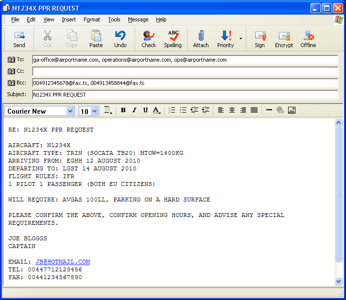
This is an example of an "initial contact" message:
The above example contains several time-saving tips. The message is faxed using email2fax using the BCC field (the @fax.tc is a particular method used by Interfax). Because faxes do not have a Subject header or a return address like an email has, all this stuff has to be repeated in the body of the message. Declaring that everybody is an EU citizen is likely to lead to Customs not even bothering to turn up. Declaring the tail number as US registered (in this example) could conceivably increase the risk of issues through someone not liking U.S. foreign policy (!!) but it ensures that any problems surface earlier rather than later.
The title "Captain" would attract instant ridicule in the GA community in northern Europe but it commands respect at larger airports everywhere. A pilot uniform is recommended if travelling to the 3rd World, for the same reason: respect.
Any email should be sent in plain text, not HTML. Make sure your email program is configured to send emails in plain text only, and avoid fancy stuff like underlines, bold, font changes, and colours. Avoid sending attachments on the initial contact, especially if you use Outlook (the famous "winmail.dat unreadable attachment issue" being just one reason).
If using fax, always include your email address in the body of the message because most recipients will prefer to reply by email. If you expect a faxed reply, your own fax number, supplied in the message, obviously needs to work. The most practical way is a fax2email service; Interfax offer this too. When setting up such a service, avoid non-geographical numbers (0870 etc) because these cannot be dialed from many foreign countries. It is much better to pay a bit extra for a geographical number (e.g. 01273; Brighton).
Another possibility for contacting an airport is an AFTN message. This is possible using the AFPEx tool, which is available to pilots with a UK address. A Free Text message (use the same content as the above email/fax example) is delivered instantly via the AFTN network. The message can be addressed to xxxxZTZX (Tower), xxxxZPZX (Planning Office), xxxx YOYX (AIS - the office where a flight plan is handled). In the foregoing, xxxx is the airport ICAO code. I send it to the first two; the 3rd one is a recent discovery, but at many airports all these end up on the same terminal. With big airports, this really should work 100% but I have found the response rate to be poor - seemingly because they could not believe a pilot could have AFTN access. Also, many smaller airports are not directly on the AFTN; the messages are diverted to another one which then faxes them over. And many small airfields have no AFTN access at all. When I did get a reply it was always by email. Finally, since AFPEx does not offer a copy of incoming messages to email, you have to start up the application to check if any replies have arrived. I now think that AFPEx is a waste of time, except as an emergency method for flight plan filing.
Some airports probably get fed up with pilots sending multiple messages but they have only themselves to blame for poor organisation. Many airports are bastions of 1970s working practices.
If flying to Italy, specifically check that they have avgas and will sell it to a visiting pilot, anytime during their opening hours. Many airfields there operate under some kind of tax concession and are not allowed to sell avgas to visitors. Unfortunately these airfields may show as "having avgas" in the published data... Italy has acquired a "reputation" for hassle over the years, which is probably unjustified for Italian speakers who can simply telephone, and to some extent justified for everybody else.
Exit Customs, and Workarounds
Obviously, an airport's PPR/PNR requirements will vary according to where you are arriving from, or departing to. Within Schengen, the situation is simplified - except for Greece, Switzerland and Norway... You have to sort this out before flying there (as described above) but you will face it again when departing, because most countries impose exit Customs. This is where it gets interesting...
Example: you are in Brindisi LIBR (Italy, Schengen). You want to fly to Pula LDPL (Croatia, non-Schengen). Assume that Brindisi (I've never been there myself) has "Customs PNR 12hrs" then you cannot depart without having given this 12hr notice. But if you file the flight plan for Ljubljana LJLJ (Slovenia, Schengen) which is just up the road from Pula, you can depart immediately... It doesn't take a PhD to work out a solution: file a flight plan for Ljubljana and, once out of Italian airspace, divert to Pula. To make it even more "proper" you file Pula as the alternate, and of course you contact them first to make sure they are open, etc. A completely plausible and very scenic route to Slovenia passes directly over Pula (the PUL VOR):
LIBR TROTA A48 CRAYE B9 SPL L607 ZDA N606 PUL L141 ILB LJLJ
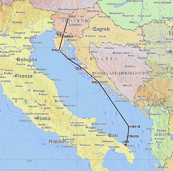
Pula will have plenty of advance notice of your arrival, starting with Dubrovnik Radar.
Another example concerning a particular airport is San Sebastian (Spain). There, "Customs" involves two different kinds of police officer, of which one turns up for work and the other one doesn't. Consequently, San Sebastian no longer supports non-Schengen flights (in or out) even though it lists "Customs" in the airport data. So, if needing to fly to the UK, one could file for Le Touquet (France) and then divert to Lydd (UK). Update 2015: San Sebastian does allow UK flights but for a large fee.
The above techniques have been known for a long time but they breach the Customs regulations of the departing country and should be used in difficult situations only, where the departure airport staff is screwing you around and where you are not planning to return to that airport anytime soon. It is a useful tool to have in your toolbox. The departure airport will know - if they actually care - where you really landed, from the AFTN message they receive after your landing, but a Pilot in Command is entitled to divert due to weather, unexpected headwind reducing the fuel reserve, etc. It goes without saying that everyone on board still needs to be 100% legitimate for the actual flight i.e. carry the correct passports, visas, etc because diverted flights draw extra attention after landing.
I would also not use this technique for a departure from an airport which does not have Customs at all, because it will be obvious to everybody down the route that you could not have possibly cleared Customs at the departure airport.
Doing things the other way around (avoiding Customs at a destination, by pretending to have departed from a different airport) is completely illegal and should never be considered.
Over the years, countless UK pilots have flown (mainly inadvertently) from non-Customs airfields in France back to the UK and I have never heard of any fallout, but it should not be attempted because the illegality of such a flight will be obvious to anybody who sees the filed flight plan, so you could get picked up well before you get airborne. Flying in the opposite direction - from the UK to a non-Customs airport in Europe - is a very bad idea too. I have heard some distressing (true) stories of pilots who were denied landing clearances (in Germany) despite reporting a fuel emergency, though this is equally (a) a failure by a pilot to plan alternates; (b) a failure by a pilot to do his job and declare a Mayday; (c) a rare example (in northern Europe) of idiotic ATC.
In the above notes, I use "Customs" generically to refer to both "Customs" and "Immigration" which are in theory handled by different police forces. For example, the UK has exit Customs but no exit Immigration.
Diverting to a PPR, Customs PNR, or no-Customs Airport
This is a legal grey area. In northern Europe, it is almost never an issue. I recall only one case of some UK grass airfield (non ATC) refusing a landing to a foreign inbound flight, but they did not have the right to do that except on grounds of a lack of PPR to land on private property. There are southern European airports which will definitely refuse a landing clearance, however, and very occassionally an airport issues a notam saying it is closed to GA and cannot be filed as an alternate (Corfu LGKR has done that).
Doing things properly, you should make sure your filed alternate(s) can be flown to as a main destination, and that includes PPR/PNR. Also check avgas availability; landing somewhere and then having to get a 200 litre drum transported there is going to cost about £1000.
Obviously an emergency (a Mayday radio call) is OK everywhere.
A diversion away from a Customs airport to a remote strip can be expected to result in serious police attention, for obvious reasons.
Long Distance VFR Touring in France
The standard VFR procedure is to plan a route outside controlled airspace (CAS), but there are many scenarios where flying in CAS yields a much better routing. Also, most VFR flights done "VMC on top" will requires a CAS transit, due to the higher level.
France offers a particularly neat solution for higher level flight, in the form of extensive Class E airspace. This has a base of (usually) FL065 and extends to FL115. Within this airspace, VFR flight is unrestricted as Class E is not CAS for VFR. UK pilots often refer to these routes as "airways" which is misleading because it invokes comparisons with the UK airway system which is nearly all in Class A and thus closed to VFR.
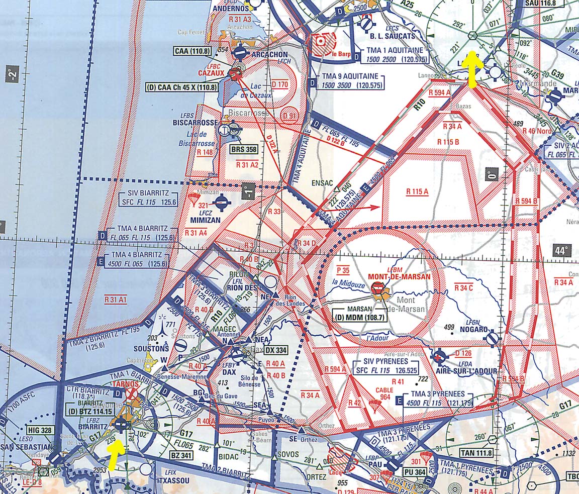
The following French SIA chart section (click on it to see an enlarged version) shows an airway R10 from the BTZ VOR (bottom left) to the SAU VOR (top right). This airway is also marked FL065 and this is the lowest level at which one can fly it and clear the various obstructions
This is a great way to fly long distances in France. They are ideal for VMC-on-top VFR touring (which a holder of a UK issued PPL can do if he has an IMC Rating or an IR) but you need to make sure (by being conservative with the weather) that you don't get trapped above a solid overcast at the destination...
Airfield Movement Precautions
Taxiing around is one of the most risky parts of flying!
I am not talking about getting lost. That too happens routinely to the best pilots - you need to have the map ready and 100% sorted before starting up, and not be afraid of asking ATC if in any way unsure. I am referring to damage to aircraft; yours or somebody else's. It is easy to ding somebody's wingtip and the damage is easily into 4 digits or more; if in any doubt regarding the clearance, shut down, keys out of the ignition, towbar out, and move the aircraft by hand, with somebody watching. If this annoys somebody behind you, ignore them... unlike you, they are possibly renters who can walk away from damage.
The other risk is prop strikes. This is a much bigger problem than most will admit; anybody who "hangs around" a hangar or an airfield will see loads of damaged aircraft. Bent blades are a daily routine in prop overhaul shops, and each one of these is (or should be; that's another story) accompanied by an expensive engine strip-down to check for cracks etc. There is a general culture among GA airfields that the airfield is not responsible for anything whatsoever, leaving the pilot/owner to claim from his own insurance. Many of them will only grudgingly fill in potholes, or sweep away rocks lying on the runway. To be fair to them, many and especially the small grass ones, are run on a shoestring and a general acceptance of liability for potholes etc would open the floodgates. I had a £20,000 lesson in this area, with a brand new aircraft which had 1hr on the tacho!
Grass airfields often have potholes, or undulations which can cause the prop to contact the ground, and some hard airfields have concrete/grass transitions where the step causes the suspension to dip enough for the prop to hit. Hard airfields also often have stones which cause dings in the prop. Such dings need to be "dressed" (basically, filed out to make a new smooth leading edge) which cannot be (legally) done by a pilot, but the removed metal will eventually lead to an out of balance prop which will need to be dynamically balanced - £300 plus. On the next prop overhaul, the blade edge has to be restored all the way along its length and once the amount of metal removed reaches a specified value, the blade has to be replaced, which for balance reasons means replacing all blades, which usually means a new prop as the only economic solution, so basically you have just paid £10,000 for years' worth of operations in airfields where nobody was bothered to use a broom.
The best precautions are: Always ask for a hard surface parking. Ask for this when initially contacting the airport and ask for it again upon arrival. They may not have any but it is always worth a try. Before departure, walk around the aircraft and walk up the likely taxi path leading away from the parked position, checking for potholes, and picking up any stones bigger than about 2cm. If there is a grass/concrete transition nearby, inspect it for the best point at which to cross it, and cross it at an angle of say 45 degrees. When taxiing, the visibility of hazards ahead will be limited but if you see Apollo-sized rocks lying on the taxiway (historically, Elstree EGTR had one of the finest collections of these, until the CAA shut it down until they did something) then get up a bit of speed before you get to them, and idle the engine when driving over the top, to minimise the chance of the prop sucking them up.
The above advice is not over the top. In one case I know of personally, a renter started up with the towbar still in place, took a 20 x 20mm chunk out of a blade, threw the bent towbar away where it would not be found, went for a flight, came back and said nothing... and vanished. If you are an aircraft owner, this is the kind of "diligent" culture you will encounter in some places. So if in any doubt, as I say above, stop, get out, and use the towbar.
Cold Weather Operations
There are two distinct issues: removing frost before a flight, and fuel icing during a high altitude flight.
Removing frost can be a way of life during the winter, if parked outdoors overnight. Water from a tap can be usable for very marginally-freezing conditions (e.g. where the temperature is already rising through 0C) but is usually ineffective because the large cold fuel mass in the wings causes it to simply freeze on the wings, regardless of how much is available. It also runs the danger of freezing up control surface bearings or even linkages, in some types of aircraft. So a de-icing fluid needs to be used, and obviously it needs to be stuff which is safe on aluminium, the windows, etc.
There is a lot of "street knowledge" on which cheap fluid is supposedly OK, but one must always remember that most pilots are not owners and will not become aware of long term damage. Most owners use the proper aviation stuff, which is not cheap unless one can mix up something which is definitely equivalent. The most obvious stuff is the TKS de-ice fluid which can be purchased (UK) from e.g. Silmid as Aeroshell 07. Kilfrost is another supplier, with slightly better pricing (for Type 1 de-icing fluid). It is very expensive; nearly £200 including delivery for a 20 litre drum.
Frost can also be scraped off with e.g. a credit card but this will damage the aircraft finish, especially windows.
Aeroshell 07 is also the fluid used in TKS anit-ice systems. The high cost is irrelevant on a prop-only system but is an issue on the full system which can use up the whole lot on one flight in IMC. Also, in Europe, one has the same issues as with oxygen in that hardly any airports provide a top-up facility, and most owners keep a drum back in their hangar.On long trips I carry a 2 litre topup bottle of the TKS fluid, which is just the right amount for completely refilling the 2 litre prop TKS fluid reservoir. For safe leak-proof carriage of this stuff I use HDPE (high density polypropylene) 2 litre bottles which can be bought cheaply from laboratory suppliers e.g. here (local copy). These HDPE bottles can also be used to carry IPA - below.
Fuel icing is a highly aircraft type specific phenomenon. In normal N European temperatures is almost unknown on the common training types but that could be because almost none of them get to fly very high. The Piper Aztec has been reported as severely susceptible to it at any OAT below about -15C. My TB20 does not appear to have had any reported cases. The standard precaution is to add some IPA (isopropyl alcohol) or Prist to the fuel, during refuelling. IPA is safe and cheap but the required concentration can be up to 2% which means that on a very long trip one has to carry rather a lot of it, which is why some people use the more effective (and carcinogenic) additives like Prist which can be added in much smaller amounts.
Airborne
Flying is the easy part of aviation!
The most straightforward procedure is if the entire flight is in controlled airspace. You collect the departure clearance (from the Ground, Tower, or Clearance Delivery frequency; there seems to be no obvious rule) and this contains the SID, squawk code, etc. For a VFR flight, the SID will be replaced by some departure instructions; usually a low level flight to some VRP.
The SID is the lateral clearance; ATC will advise the vertical clearance before departure, and it is important to realise these two are totally separate clearances in all phases of IFR flight - except when "cleared for XXX approach" at which point you are authorised to immediately descend, at the highest rate of descent of your choice, to the published platform altitude for that approach.
Getting prepared is important. Make sure you have all the SIDs ready, and also the approaches in case you need to make an emergency return. The simplest thing - the airport map - is vital and you need to work out where you are parked, before calling up for the taxi clearance.
Most airports don't care if you start a piston engine without a startup clearance, and at many of them the tower cannot see the GA parking area anyway. But some do get funny about it, so it is always good to "request start" just in case.
For an airfield outside controlled airspace, a provisional IFR departure clearance (not really a "clearance" as such because nobody has the power to issue a clearance outside controlled airspace) is collected either from the tower or from the regional FIS unit (in the UK, usually London Information).
On flights filed for a decisive airways level, say FL100+, the next unit to speak to will be London Control, and they will usually issue rapid climb instructions to the filed level. But you don't want to fly into something nasty while obeying the instruction, so if there is some convective weather around, a good trick is to climb as far and as high as one can in an appropriate direction before calling up London Control.
One odd thing I have found is that some airports peripheral to big cities use not only their own published SIDs but also SIDs belonging to other nearby airports; for example Pontoise uses some SIDs published for Le Bourget. This is mentioned as an obscure one-liner in the Pontoise AIP...
Maintaining one's IFR clearance: Just because a route is accepted by the Eurocontrol computer does not mean that ATC will operate it in the air as a fully IFR flight. One can file an "IFR" route, hundreds of miles long, at 2000ft, but since all or part of it will be outside controlled airspace (CAS), UK/European ATC will not provide an IFR service on the flight. 2000ft is an extreme example, but it is easy to file a route at e.g. FL070 which is "dropped" by ATC because it has departed CAS at some point. And it can happen at higher levels. It can also happen for other reasons e.g. when flying from France to the UK, below FL120, one can get "dropped" because the French unit does not have a handover agreement with the UK unit. It is difficult to establish the exact limits for this but it remains a persistent problem for IFR pilots wishing to fly at sub-oxygen levels. Leaving France at FL120+ appears to solve it (through being handled by Paris Control, which can hand over directly to London Control) as would flying along certain routes such as ORTAC-SAM. The France-UK situation improved c. 2010 when it became apparent that one can stay with Paris Control as low as FL100.
Oxygen is highly desirable. It is a legal requirement above 11000-12500ft (the exact rules also depend on the State of Registry of the aircraft) but its use anywhere above about 8000ft makes a huge difference to how tired one is upon arrival. Some people are significantly affected above about 11000ft, especially at night. Subject to aircraft performance, it enables a climb above the clouds, out of icing and turbulence, and being able to file at FL140+ often yields much better routings than at say FL100. Oxygen is one of the greatest "secrets" of IFR flight, and the equipment can be obtained relatively cheaply in a portable form.
Airborne collection of IFR Clearance, following a VFR departure
This can be a particularly dangerous phase of the flight, and one needs to have a clear "plan" for what to do if there is a delay in getting it.
The strategy depends a lot on the kind of airspace in the vicinity of the departure airfield, and weather.
If there is no CAS nearby, in the direction of the flight, and the weather is very clear, then one can simply commence the flight and sort out the IFR clearance whenever it gets sorted out. An example of this is a departure from one of the UK south coast airfields, when the tower is unmanned; in this case the first contact is London Information who are supposed to provide an FIS while waiting for the transfer to London Control for the proper IFR service. It is common for London Information to take 10-30 minutes to do this, during which time one has flown quite a distance, and it is obviously helpful if the distance flown is in the general direction where one wants to go! So departures to the south, east or west are usually OK (ones to the south often result in you being in French airspace before London Control come back) but ones to the north cause you to be trapped at low level under the LTMA, with no chance of a climb due to the Gatwick/Heathrow flight paths.
If there is CAS nearby, it can get tricky. I recall this departure from Messalonghi in Greece, where an IFR clearance was never formally obtained and, as far as I could tell, the flight remained in limbo (VFR or IFR?) until I landed at Corfu LGKR. Now combine this with some terrain and poor visibility... In the extensive UK Class G airspace you can just drive straight into IMC without talking to anybody but in most countries it is illegal to enter IMC without an IFR clearance (notwithstanding the fact that nobody can give you a clearance for anything when outside CAS) or, to put it more generally, it it illegal to fly IFR outside CAS. Nevertheless pilots do get killed while fumbling around in the air, calling up various frequencies, or simply waiting for an IFR clearance, while trying to stay clear of terrain, in or out of VMC... It may be better to stay on the ground until the weather improves. In some countries one can pick up an IFR clearance pre-departure, with a phone call, which is a great solution, but this is rare in Europe.
There may be "weather" in the departure area in the intended direction of flight, but not in some other direction. In that case, a useful trick is to depart in the latter direction and climb right up to the base of CAS, before calling up anybody for the IFR clearance. This may enable you to get above the clouds, where one can size up the conditions a lot better than from the ground.
The worst case scenario is a departure from an airfield which one cannot safely return to due to low cloud, followed by an inability to get the IFR clearance... the "inability" could be a radio failure, or terrain masking of VHF comms. This is why any pilot doing this sort of flying should have a GPS running a real topographical map of the area, or at least an electronic version of the "real printed" VFR chart. Total 100% terrain awareness is a must.
After Landing
If refuelling, always refuel immediately after landing. In most situations, one has a bit of time at that point - more time than one usually has when departing. But the biggest reason is that most airports are dead keen to get you off the airside ASAP, for "security" reasons. If you refuse to leave the aircraft until avgas turns up, avgas will turn up far quicker than it would do otherwise. Commonly, a van turns up within minutes of parking up; if you tell the driver you need avgas now then he will make the right calls to the right people, fast.
If staying for a known period, try to also pay all fees after landing, for the same reason.
This one will sound really obvious: on your way out through the terminal building, find out exactly what you need to do to get back in, to pay for stuff, and to get out to the aircraft. Some quite sizeable European airports are practically deserted - except for the cleaners, who won't speak English - and the whole place comes alive, briefly, a couple of hours before the Ryanair flight is due... I have spent an hour at Bastia (Corsica) and Zaragoza (Spain) trying to find someone who could speak English enough to understand "general aviation", and that included the Tourist Information desk staff at Zaragoza. You can find the same at most provincial airports in France e.g. Poitiers or Bergerac can be totally deserted except for a man in the tower, and the fire crew watching football on TV. Obviously, this is where mobile internet really helps because you don't have to mess around filing flight plans, etc. But if you depart without paying every last penny the airfield will pursue you, which can cause considerable hassle if they don't have your name and address.
Avoidance of Handling
Most GA pilots regard avoidance of handling (or "self handling") as the Holy Grail; unsuprising given the usual silly costs. It is not unusual to find a big airport where the landing fee is say £50 but the handling inflates this to £150. In most cases, for light GA users, handling offers next to nothing for the money.
If handling is "non-mandatory" then it usually won't be offered (to piston GA) but can anyway be avoided by refusing any offers of handling.
If handling is "mandatory" then it can usually be avoided by visiting a local flying club or a business based at the airport. Oviously the latter tactics need a prior arrangement with the club/business; you cannot just park up at some club or maintenance company and walk off. The intention to park at the specified establishment needs to be passed to ATC immediately after landing. At "mandatory handling" airports, the handling agents are wise to this revenue-reducing practice and may press you for details of what "maintenance" you are having done...
The top-priced airports (e.g. Gatwick, Frankfurt, Munich) whose total costs are in the £500 region are all "mandatory handling", as far as I can tell. The landing fee is only about 1/4 of the total cost. The handling agents (e.g. Harrods Handling) are wonderful and exceedingly posh, employing the world's supply of well dressed women, but as a light GA user you are just paying £400 for coffee and fresh croissants. This whole business is propped up by business jets whose owners don't care what it costs, and by airport management which cannot be bothered to make a provision for light GA.
However, handling agents do have their uses. At many airports, the handling agent is the only bit that is run in a proper businesslike manner. They have the right connections around the airport and can usually instantly arrange PPR/PNR and one phone call to the agent can be all that one needs to do prior to flying there. Prior to departure, the agent should produce a customised weather briefing and take care of filing a valid Eurocontrol flight plan; these functions are much less relevant these days, but if you are in a hurry to get away, it is an option. The handler is also much more likely to speak English than airport staff. This is how aviation is "supposed" to work - worldwide - and it is only piston GA pilots who keep trying to circumvent the system, to save money... So if the airport is not replying to your emails, phone up the Handling company.
At certain more southerly European airports, the handling agent will use a part of his fee to "lubricate" the right people to ensure that an "impossible" parking space magically appears. Outside Europe, this kind of thing is much more overt and regulars tend to carry wads of US dollars, etc for paying bribes to various officials.
Unsuprisingly, handling is the normal way of doing things at the business jet level, because a lot of the flights are done at short notice and nobody has the time to mess around sorting out PPR, in-flight passenger refreshments, etc. At the top end of the piston GA scene, there are pilots who prefer the comfort of a handling agent. If using a handler, try to use one with a permanent base on the airport; these can often be identified by the presence of a discrete radio frequency in the ACUKWIK listing.
In the EU, mandatory handling is reportedly illegal unless there are at least two agents to choose from. In practice this makes little difference because they simply agree to set similar prices...
Avgas Duty Reclaim
In most of Europe it is possible to get fuel free of duty (taxes) and VAT, on production of an AOC. However, an EU regulation (local copy) mandates duty free fuel for non-private operations, so the suggestions in the aforementioned link may be worth exploring.
In the UK, one can reclaim duty on fuel that has been exported. This highly valuable concession is called the Duty Drawback and currently (2015) is worth about 20% of the fuel cost! Under this concession you can claim for the entire content of the fuel tanks, even if the foreign trip was brief; it works on a principle similar to airport duty free shopping where you can obviously bring the duty free goods straight back to the UK. Obviously, the fuel claimed for cannot be claimed for twice... so some administration is required to make sure this does not happen.
Fuel Payment Methods
This used to be an issue, necessitating the carriage of Visa, Mastercard, AIR BP and other fuel cards, and plenty of cash, but I have seen a big improvement over the past few years. Today, a Visa card works at nearly every manned airport.
However, there are exceptions:
France has many small airfields with self-service pumps, which require the TOTAL fuel card - a load of hassle for most people. The card needs a French bank account, or an account with a bank offering SEPA. Fortunately most of these airfields are non-Customs and thus unlikely to be visited by an internationally travelling pilot.
More recent developments are self service fuel pumps which accept the AIR BP card. There is a lot of these in France. I also had one at Zell am See (Austria). I have had the AIR BP card for many years and always tried to use it, but most airports do not accept it. So now it is becoming useful again!
Most of these self service pumps have menus and button labels in the local language only, so local language competence or local help is required. I have had that issue everywhere, most recently at Bastia, Corsica. Usually, the fire crew has somebody who can work the pump...
Aircraft Ownership
This is a vast topic so I will mention just a few general points that are applicable to the owner of an ICAO certified aircraft.
For an aircraft owner, maintenance is the biggest learning curve, largely because most of the GA maintenance business is geared up to make money on the back of the lowest common denominator: owners looking for the cheapest legal job; many of these are flying schools. And there is a vast range of practices that go on. With most of these - dodgy lubrication being the main one - the culprit is untraceable except via increased airframe maintenance costs years later. As a result, piston aircraft ownership is not like owning a BMW, which you can take to any BMW dealer and get a reasonable job done - most of the time.
Speak to other owners and find out where they get their maintenance done. Having found a company which comes with reasonable recommendations, you need to get pro-active and be involved in maintenance - even if a Part M company is "in charge" of it nominally.
Get hold of the maintenance manual for the aircraft. These are often expensive; some manufacturers have sold the rights to a U.S. firm called ATP who sell a CD based subscription for about $1000/year. Each month's CD is supposed to go in the bin when the new one comes out, but except on current aircraft types very little changes from one year to the next and the out of date CDs make a great educational reference. Sometimes they appear on Ebay...
One learns a tiny bit about how airplanes work in the PPL but this is nowhere near enough.
Many owners will prefer to leave everything to their maintenance company - this is OK if you have a good one.
If you are buying into a group (a syndicate) then meet all the members and see how well you get on with them, etc. They will no doubt be polite to you because - at best - they don't want to obstruct the sale of the share or - worse - they are keen to see the back of a troublesome member, so you need to go beyond that and check out what kind of flying they like to do, what they do for a living, their flying patterns, etc. The group members need to be well matched in their ability to fund unscheduled maintenance, in their attitude to VFR v. IFR (a mostly-VFR group will not be keen to replace failed IFR avionics, forcing IFR-capable members to jump ship), and in their flying patterns (some groups have a dominant member who does a lot of hours). Ask about their duty drawback policy; some groups allow the entire drawback to be pocketed by the pilot flying abroad, which means his overseas trip has been subsidised by the others. Ask who is in charge of stuff like insurance, and deciding what "optional" stuff gets fixed during maintenance. Some groups work very well but they tend to be either small groups comprising of well matched members, or large groups which provide cheap casual flying but have a dedicated "manager" who does all the admin.
Photographs
One of the biggest attractions of flying is the potentially great scenery. Unfortunately, it is not always easy to get acceptable photographs. The biggest problem seems to be reflections from surfaces and objects inside the cockpit; other issues include: the camera focusing on the window and not outside; poor contrast; poor focus.
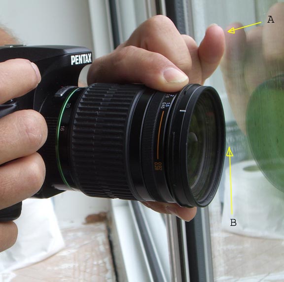
The most effective way to avoid reflections is to hold the camera close to the window surface - but not touch the window as that transmits high frequency vibration to the camera which blurs the picture. A simple method is to press one finger (A) of the hand holding the camera against the window; this stabilises the camera while making it possible to maintain a small gap (B) between the camera and the window:
The relevant area of the window should be clean and scratch-free, otherwise the contrast is poor and the camera may autofocus on the scratches instead. If a clean window is not an option, make sure the camera is set to manual focus and is focused on infinity. This can be tricky to do exactly because on modern lenses true infinity focus is just before the mechanical stop... In general, use the smallest available F-number as this minimises the effect of a bad window. Most lenses are sharpest at F8 and this is what I usually use if there is enough light.
If reflections remain, identify the object causing them and relocate it, or cover it up. Often, the bright papers on the kneeboard are the cause; turn the kneeboard upside down. In extreme cases, use a piece of a black cloth to cover up the offending item.
If possible, take pictures out of a window opposite to where the sun is shining i.e. try to fly to the south (northern hemisphere assumed) of the object being photographed.
High shutter speeds obviously help but the very high speeds offered on modern cameras (e.g. 1/5000) are largely illusory from the point of view of freezing motion because once you are above the "flash sync speed" (usually 1/180 to 1/250) the shutter does not actually open and close in 1/5000 of a second. It forms a variable-width open slit which moves across the image at the flash sync speed (i.e. 1/180) so at say 1/5000 you just get a very narrow slit which moves relatively slowly across the image. Some very new cameras offer an electronic shutter which will give a genuine 1/5000 but no current (10/2015) DSLR does this.
Formation photography requires additional tricks. Obviously, one must avoid a collision and various well tried methods exist for this. I tend to ensure separation by well spaced departures and climbs to pre-arranged altitudes, separated by 500-1000ft, with the later-departing aircraft climbing to the lower altitude, to a GPS waypoint at which one can orbit until visual contact with the other aircraft is acquired. Then, one can fly parallel tracks and get the photos. As above, use the sun to your advantage by having the camera aircraft flying on the south side of the other one. Obviously, safety is vital and a second person is highly desirable in the camera aircraft - to take the pictures and to keep a lookout. An autopilot is extremely handy...
There appears to be a consensus that the most attractive photos of another aircraft are those which show about 20-30 degrees of the propeller blade's rotation
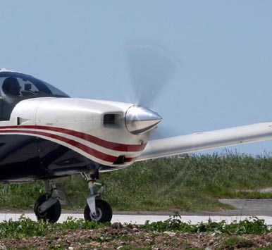
which implies a shutter speed of around 1/160 to 1/250 - much slower than the 1/1000 to 1/5000 normally used in bright conditions with an ISO100 camera. This requires a steady hand and - if the other aircraft is doing a fly-by - panning of the camera. Shooting at high speeds produces a variety of unattractive "frozen propeller" effects. All the "webcam" cameras (e.g. GoPro) suffer badly from this.
A good article on the above is here.
Finally, a reasonably good camera makes a big difference. Most of the sub-£200 compacts, and all phone cameras, are of poor quality - even if the resolution is 20M pixels or more - because their lenses are so small. However, you don't need to be equipped like an F16 plane spotter in Greece to get very good pics; there are pocket-sized cameras whose optics are just that bit bigger and a lot better.
Many airborne pics are spoilt by haze, which in southern Europe can be present even at high altitudes (above 10,000 feet). There is nothing that can be done about it with filters, but adjusting the Levels in Photoshop manually (adjusting R,G, and B separately) usually produces a good result. Some info here on a good procedure. If you use RAW, Photoshop, and Lightroom, offer a "Blacks" function which is a quick and dirty but fairly effective way to reduce the haze. The best way to reduce haze is to fly in the clear-air conditions found after the passage of a front.
Filters are rarely used with modern digital cameras. They were routinely used with film to match the colour temperature of the light source to the fixed spectral response of the film, but a digital camera has a user setting for the colour temperature. However a circular polarising filter works very well in reducing reflections and glare from water and it enhances colours. Unfortunately, to get the right effect, it needs to be rotated for each shot; you can't just screw it on and shoot away in all different directions.
If shooting through a propeller, there are two ways to get rid of the prop blade(s): take many pics and hope that you eventually get a clean one (which works a lot better with a 2-blade prop than with a 3-blade one), or use a slow shutter speed of about 1/80 or slower.
Most of the above notes apply equally to movie cameras, but these have their own issues if shooting through a propeller. All the compact "webcam" or "bullet" cameras (I tried quite a few - e.g. GoPro) suffer badly from this because they don't have an iris; they use the electronic shutter alone to control exposure, and in most daylight situations the shutter speed ends up being far too fast to properly blur the propeller. My experiments have shown that a shutter speed or around 1/120 (or slower) is needed to eliminate the prop effects. Unfortunately few cameras below £1000 have any user configuration for the shutter speed. The excellent Canon HF-G10, at over £1000 at the time (2012), is one of the cheapest ones which has a shutter priority manual mode. Where no user setting is available, one can try a neutral density filter to reduce the incoming light and to force a slower shutter speed, but this rarely solves it adequately. I tried some pretty heavy neutral density filters with a Sony HCR-HC1E (£1500 when new in 2006) and they did very little...
[work in progress]
Last edited 26th October 2015
Any feedback, reports of dead links, corrections or suggestions much appreciated
Contact details
