Trip to Paris - March 2010
This article describes a very straightforward IFR (airways) trip from Shoreham (EGKA) in the UK to Paris / Pontoise (LFPT) in France, and back the same day.
Procedurally, the flight was very similar to other airways flights I have done. Other VFR and IFR trip reports can be found here. IFR flying tends to follow a set pattern, with the main variable being the weather.
This is one of the shortest IFR flights (in the European airway system) I've ever done, and is certainly the shortest I have ever written up. On a nice day, many instrument rated pilots would have chosen to do a flight like this under VFR, and any PPL can work out how to do that (get the VFR charts, draw lines on them, etc) but this article illustrates the relative simplicity of flying it under IFR.
Here is a glossary for non-aviation readers.
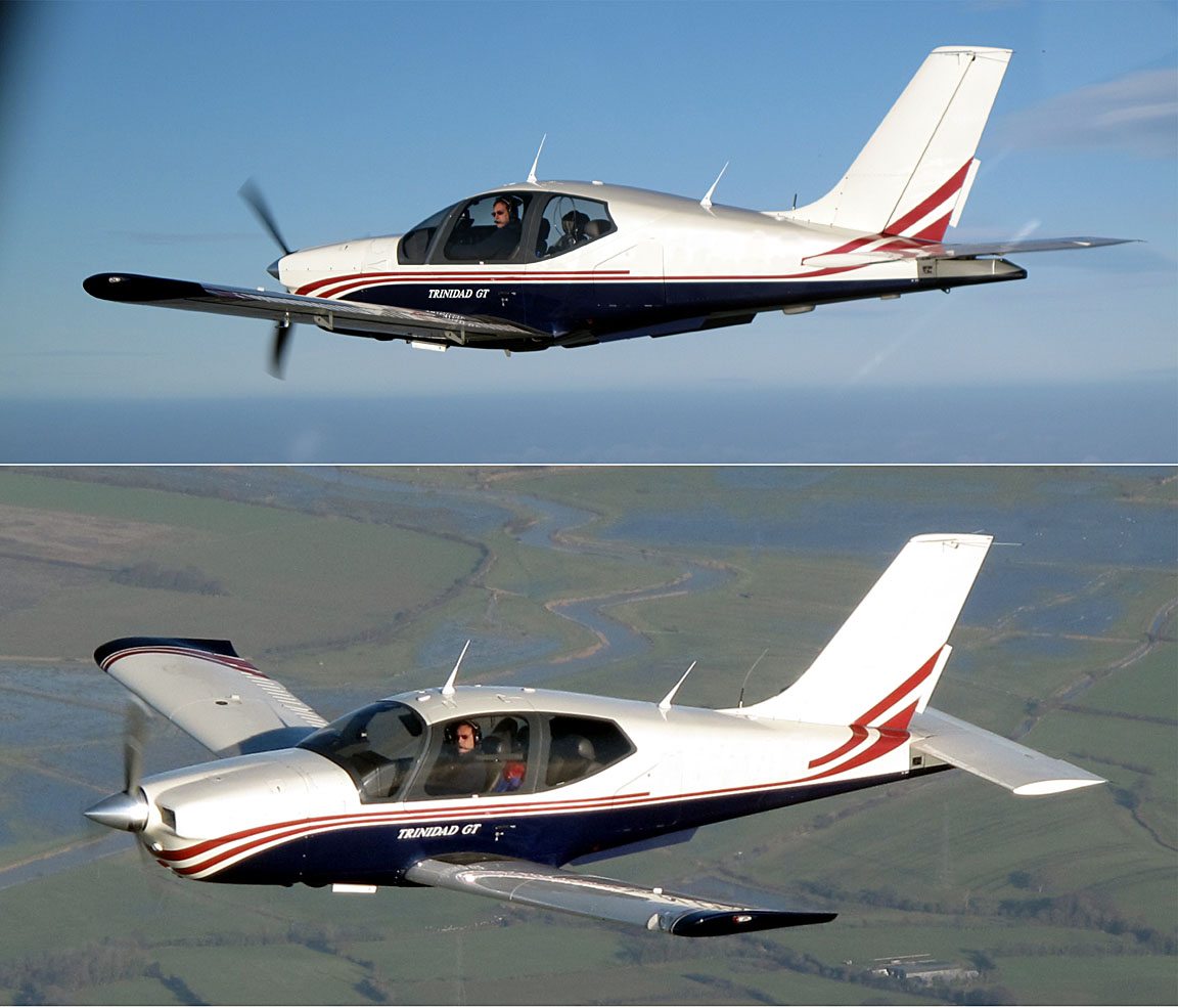
Aircraft
The aircraft is a 2002 Socata TB20GT which has a zero-fuel "book" range of approximately 1100nm and an economical cruise speed of 155kt TAS at 10,000ft. Extra economical cruise power settings can extend the zero-fuel range to 1300nm which, according to FAA rules, translates to approximately 1100nm with IFR reserves. It has a ceiling of about 20,000ft and is equipped with oxygen. It is not certified for flight into icing conditions but has a TKS de-iced propeller.
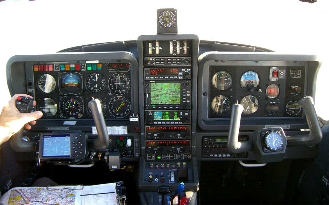
Navigation equipment includes a KLN94 IFR/BRNAV GPS and a KMD550 MFD and these are used for primary navigation. IFR flight in Europe above FL095 (generally) requires BRNAV certification which in the GA context is met only with a BRNAV approved IFR GPS installation. The most common means of BRNAV compliance is one of the Garmin 430/530 products but many other panel mounted GPSs have been approved.
The aircraft has a KFC225 autopilot which can track VOR/GPS/LOC/ILS and fly a preset altitude or a preset VS. There is an additional battery powered Garmin 496 GPS which also provides an audio terrain warning (TAWS) function with a European terrain and obstacle database. A WX500 stormscope is also installed. Two independent VOR and ILS receivers are installed.
Flight Planning Equipment
In this case, being a very short trip, all planning and flight plan filing was done at home, before departure, on my PC. On the trip, I carried a laptop just in case. Nowadays it is easy to get TAFs and METARs on any modern mobile phone capable of WWW access, but unless one carries a huge "phone" a laptop is still required for anything more complicated. The laptop has GPRS/3G internet access, via a bluetooth-connected mobile phone, which provides independence from airport weather briefing and flight plan filing services.
On a short-duration trip like this, it makes sense to file even the return flight plan in advance, because cancelling or delaying it is much easier than filing it.
Weather
More detailed notes on weather planning are in this trip writeup.
I normally avoid frontal weather because the cloud tops tend to be above the aircraft ceiling (20,000ft).
The outbound and return flights were on the same day: Monday. The MSLP charts Monday 0600 1200 showed good conditions - no fronts - for the two days, with no deterioration 0000 1200 on the day after. The MSLP charts also indicated light winds.
As for SigWx, they 0600 1200 showed nothing significant. These charts show weather hazardous to jets and other larger aircraft, and are much less useful to non-deiced pilots. Contrary to widespread belief, they do not show cloud tops.
The IR satellite image on the morning of the flight showed no high altitude cloud along the route (shown approximately in yellow)
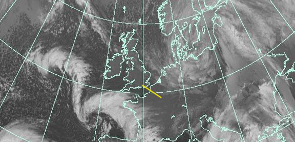
On these images, the whiter the cloud is the lower its temperature and thus the greater its altitude. High altitude cloud, say FL200 plus, shows up as something approaching solid white. IR imagery which contains a temperature scale (enabling a more accurate altitude estimate; if necessary by reference to altitude/temperature data which for some reason is a lot more accurate) is available but I have not found any which is free and less than several hours old...
When IFR, I always fly the enroute section VMC on top and have spent a lot of time trying to understand cloud tops forecasting. An article on tops is here. However, tops forecasting is far from reliable and, to an increasing degree, my IFR go/no-go decision is made on the day, on the basis of the TAFs/METARs (for surface conditions) and the satellite IR image (for enroute / high altitude conditions).
Finally, on the morning of the flight I got the TAFs and METARs which showed good conditions - fine for VFR, in fact.
For good measure, the radar image and sferics (lightning) were obtained and both showed nothing.
Preflight Procedures
IFR route design: Various methods have been used by private pilots to develop IFR routes which are acceptable to the mysterious Eurocontrol (often interchangeably called CFMU or IFPS) computer in Brussels. Airlines employ dedicated ground personnel, business jets subscribe to variously pricey flight support services, but prior to mid-2008 there was no satisfactory solution for private pilots. The best available was an Italian "ASA" flight sim enthusiast website, which is still around but its output tends to require a lot of hacking before it validates. Around mid-2008 the problem was comprehensively solved by the excellent Autoplan tool which developed a route through the airway "maze" and then submitted it for validation to Eurocontrol while iteratively modifying it. However, about a year later its developer gave up the struggle with Eurocontrol's constant goalpost-moving which was apparently motivated by a desire to stop such tools working. Since then, FlightPlanPro (FPP) has taken over, is being continually developed, and remains by far the best tool for this pointlessly complicated problem. It delivers good routings about 95% of the time.
Unfortunately, FlightPlanPro failed to compute valid routes for this trip - apparently due to incomplete SID/STAR data for the Paris airports. There is no public-domain SID/STAR database. The next option I tried is a recent development from Eurocontrol: a function which offers "suggested" routes. This function is accessible via Avbrief. Membership is required but it is very reasonably priced. EuroFPL also offer the same Eurocontrol route-suggest feature, for flight plans which fail to validate, and it is a free site. FlightPlanPro also offers this feature by simply pressing a button, but you need Avbrief membership for that to work. Most of the time, these routes are impractical due to an excessive distance overhead (20% to 60% is not unusual - largely because the whole route is at a single level) but very occasionally they work out just great, and luckily did so on this occassion.
The Eurocontrol "suggest route" feature can be productively used together with FPP, because the former is good at delivering departure and arrival routes (unsuprising, since it uses Eurocontrol's SID/STAR data), while the latter is good at delivering an efficient enroute portion.
Interestingly, the ASA site delivered EGKA DCT SFD M605 DPE STAR LFPT which is correct if you dig out one of the LFPT STARs and replace STAR with its termination waypoint. However it failed miserably for the return route...
Finally, on a short route like this, one could always hack a route by fooling the Eurocontrol computer with a series of DCTs e.g. LFPT DCT OPALE DCT DPE DCT SITET DCT EGKA. All the computer checks for in this case is that each DCT doesn't exceed the MAX DCT distance for the airspace(s) which in this case, FL100+, is 50nm, and no DCT leg crosses a national airspace boundary (hence SITET). If you exceed the DCT MAX parameter, you get the famous Eurocontrol STAR LIMIT EXCEEDED error message, and it's time to throw in some intermediate waypoints to break up the DCT leg(s). However, if such a route is hacked together without reference to VFR charts, notams, etc, it could easily cut into some military area which, at best, means that ATC will tell you to keep out of there, or require a climb above it. In "less civilised" bits of Europe, things could get more messy, and remember such a route is not going to be checked for terrain clearance; one could file a DCT through Mont Blanc. Of course, DCTs are unavoidable for connecting the enroute section to an airport which has no published SIDs/STARs. Some notes on European airways routing hacks are here.
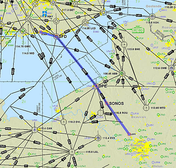
The outbound route:
EGKA (Shoreham)
DCT SFD M605 DPE J151 SONOS DCT
LFPT (Pontoise)
FL160
138 nm (GC) 141nm (airways)
Alternates: EGKA (Shoreham), EGHH (Bournemouth)
The filed level was FL160. Normally I file for FL140 or higher as this yields better routings than lower down, places the flight decisively in controlled airspace, and places the enroute section above the clouds most of the time.
The return route:
LFPT (Pontoise)
DCT OPALE J20 ABB T27 GURLU Y8 WAFFU DCT
EGKA (Shoreham)
FL160
138 nm (GC) 156nm (airways)
Alternates: EGHH (Bournemouth)
Flying back to the UK, and where sections of the route are outside controlled airspace, it is desirable to file and fly at/above FL120 because that ensures a handover from Paris Control to London Control which preserves one's IFR clearance. Lower levels generally result in a handover to London Information which is a non-radar unit and such a handover amounts to an eviction from controlled airspace, which can be a problem if one wishes to remain above bad weather until the last moment. This issue is route-dependent and there are routes back to the UK which lie in controlled airspace at lower levels, e.g. FL090 via KONAN, and some are even lower, and London Control should maintain their service on such routes. However, unless good weather is assured, the best strategy is always to remain as high as possible for as long as possible. Above FL120-140 one can get transits of the busiest airspaces.
Of course, FL160 requires oxygen but I never fly anywhere seriously without oxygen because doing so nearly halves the aircraft operating ceiling and discards by far the most attractive weather/ice avoidance option: climbing to VMC on top. I also use oxygen anytime at/above FL100; the flow rate at FL100 is very low but it keeps you fresh and you don't arrive tired.
In "classical" IFR, the terminator of the inbound enroute section (e.g. SONOS on the outbound flight) must join up with the initial waypoint of the Standard Arrival (STAR), and similarly with the outbound enroute section which must join up with the Standard Arrival (SID). I immediately noticed that neither of the above routings thus joined up. However, I decided to take no action on it since the routings came from Eurocontrol itself and thus "had to be perfect", and the whole of Paris was obviously radar controlled anyway so these things tend to sort themselves out...
PPR (prior permission required) was a possible issue. Like many European airports, Pontoise is "Customs PNR"; I sent them a message the day before using the free text messaging facility in AFPEx; they did not respond so I sent a fax to their Operations number and another to their Customs number. Most unusually, an ATCO phoned me back to say they got the fax and would advise Customs.
Flight plan filing was done electronically, at zero cost, using EuroFPL. Normally I file flight plans using the AFPEx AFTN messaging tool, but EuroFPL has two advantages: it is a data-efficient website which is usable over a slow GPRS/3G connection, and it has a flight tracking facility which enables someone on the ground to monitor your progress. More notes on electronic flight plan filing options are here.
Note: The Eurocontrol routings given here and elsewhere will most likely not work by the time you might try them because the precise form needed to get the route into the Eurocontrol computer in Brussels changes from one week to the next, and there are frequent differences between weekdays and weekends which are largely due to a lack of military activity on weekends. However, fragments of old routes can be useful even if the route does not validate as a whole anymore.
Fuel Planning
Fuel was not an issue on this flight, involving around 40% of the aircraft zero-fuel range and that is assuming one diverts all the way back to the departure airport.
Outbound Flight
The provisional departure clearance issued by Shoreham was "after departure, on track BOGNA, remain outside controlled airspace, squawk 6324, contact London Control 133.175".
Almost immediately we were cleared to FL120 direct DPE (Dieppe). Having received the FL160 climb clearance, I asked for a "stop climb" at FL140 (as this would take us nicely above the clouds ahead), then onto Paris 124.85.
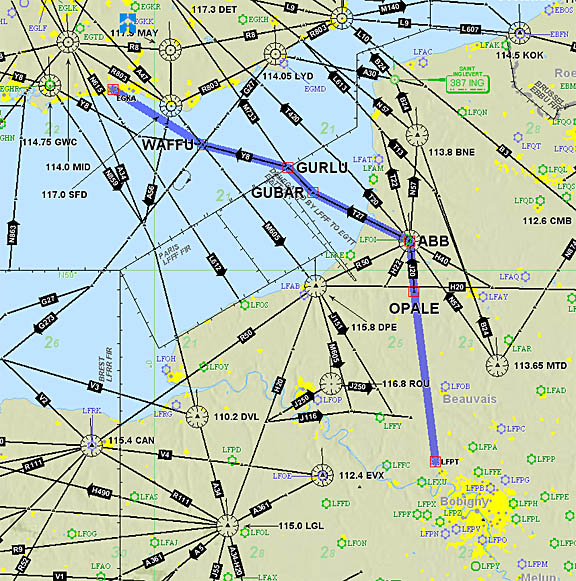
Looking at the cloud cover over northern France on the way to Paris, the FL140 level was well chosen
Paris cleared us direct MERUE, and then some headings and a descent to FL060, then Charles de Gaulle 124.35, then more headings, a descent to 2000ft, then Pontoise Tower who issued more headings and a clearance for the VOR23 approach.
The STAR allocated by CDG was not shown on the Pontoise charts. I queried this but CDG assured me the approach would simply be radar vectored...
At the start of the descent, with the temperature at -16C, the KFC225 autopilot emitted the TRIM IN MOTION audible warning. This happens when it has been trying to trim continuously for more than about 10 seconds. This never happens in normal flight, and suggests a failed pitch trim servo or a stuck pitch trim mechanism. The only way one can get the "trim in motion"warning in "normal" flight is by doing a "Turkish 737 at Amsterdam" i.e. bringing the plane to the stall, from a decent cruise speed, by continuously and fairly decisively reducing power back to idle and thus forcing an uninterrupted autopilot trim action. The autopilot was manually disconnected and a thoroughly frozen pitch trim was immediately apparent. The rest of the flight was flown manually. Fortunately the trim was frozen at the cruise speed setting, so one could descend simply by reducing power. The trim was found to be unfrozen around -1C so clearly this was not water ice because water melts at 0C and the time lag between the OAT and the trim mechanism temperature was substantial.
Things got more interesting later... Radar vectors were issued to the VOR inbound (track 230) but the HSI was not converging as expected. I could see clearly where I was from the GPS moving map, but the HSI bar indicated a continual half-scale left - continuously as the inbound track was crossed. This time - exceptionally - I was flying the VOR approach with the VOR receiver and not with the GPS's OBS mode, and the result (aircraft track in green) was not pretty
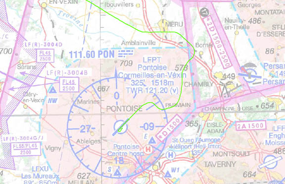
The initial turn onto the inbound track is about right, but this was ATC directed, and it was after that the effect of the VOR problem shows. If this was real IMC, I would have chucked away the VOR as soon as the lack of intercept was apparent and sorted it out using the GPS, but the later part of the approach was in VMC so the situation was recovered with a right-base visual approach. ATC were puzzled; I reported that it must be an instrument error. They probably thought "yeah, right....." or the French equivalent... On short final, both VOR receivers indicated correctly. Sadly I did not get a picture of the instrument indications.
I do know how a VOR works and the indication was definitely wrong. Initially I suspected a marginal signal issue, perhaps caused by a bad cable connection. US registered aircraft must have a VOR test every 30 days; I had occasionally encountered less than great VOR reception on NAV1 (which was used for the above approach, being the HSI) but it was very occassional and could never be reproduced. NAV1 is invariably used with the GPS however, and NAV2 always tested fine. The aircraft also had a full VOR/ILS avionics ground test (done with me watching closely) only a week or so beforehand, so this was a puzzle.
A week later a flight test was done, to check for marginal VOR reception caused by possible interfering sources e.g. mobile phones. The PON VOR could not be received from UK airspace (at practical levels) but it was soon discovered, using the SFD VOR, that there was a VOR blind spot at 3 o'clock, plus or minus about 5 degrees i.e. pretty narrow, but exactly in the wrong place for the above approach on which the last bit of the intercept track (approximately 140 degrees) would have been in that blind spot. The instruments also took a number of seconds to recover from the blind spot.
The blind spot was evident even just 10nm away from the VOR so it was not caused by any signal strength problem, and the morse code ident was always present, albeit with a lot more background noise when flying on that very specific bearing. Under the worst-case conditions, the "invalid" flag would briefly appear, but this test showed that one could have a basically useless VOR receiver despite the flag not showing and the morse code ident working... this was proved with both (independent) VOR receivers. They do however share the same antenna, comprising of two rods, and if one of these has a broken connection that would explain why both VOR receivers got wiped out in the blind spot.
No significant interference from any portable electronics in the cockpit was detected.
The GPS remained rock solid throughout. The lesson learnt was to never again fly a VOR approach using the VOR receiver only, when a far superior tool (GPS) is available!!
Pontoise was found to be a very quiet airport, with no aircraft activity. A very friendly lady in the office advised us that they collect aircraft details and send landing fee etc bills out every 1-2 months. The other option was to wait a possibly long time while a payment was processed in the office. So we opted for the "bill" but left them with contact details because the only address for a US registered aircraft is the US trustee, and the trustee does not like forwarding invoices!!
Visitor aircraft parking is East of the tower (the main parking areas is reserved for locally-based a/c) and one briefly enters the runway to get there. There is no apparent "C" on display - you must enter the tower from the road side to book in.
Paris
It was only a lunch and a very quick walk-about ...here are a few pictures...
The taxi to the tube station "Cergy Prefecture" on the Red "A" line was 20 euros and the return ticket to Paris was about 10 euros. I estimate the Tube journey to have taken 45mins and the taxi about 10 mins.
Given Shoreham's early closing time of about 1800Z, one could not recommend Pontoise for a decent day trip to Paris because the total time spent travelling, from arrival/departure to city centre, is going to be 3-4 hours. But it is certainly cheap and apparently quiet.
Next time I will try Toussus (LFPN) which appears to be nearer to Paris. However, feedback from other pilots suggests that any gain in time is small.
Return Flight
On departure, the SID allocated was OPALE1M. Like the STAR earlier, this was not shown on the Pontoise charts. ATC replied that it is a SID for Le Bourget (LFPB)! I did not have the plates for LFPB. And sure enough there is an OPALE1M at LFPB. However, it is not obvious how one is supposed to join it from LFPT. The STAR plate does not even show where Pontoise is. OPALE1C would be a bit more obvious, does show Pontoise (PON) nearby, but still does not show any obvious joining connection.
Later I discovered that this is obliquely documented in the French AIP but it is not something most pilots would expect. The Jeppesen plates (which are the worldwide standard for IFR) do not mention it. In the French AIP for LFPT here (local copy) on page 2 it states "Voir / See AD2 LFPB TEXT 1 > TEXT 4". LFPB is Le Bourget. However, that reference takes you to the AIP page AD2 LFPB SUM here (local copy) where no relevant match for "LFPT" is found. Apparently, one is expected to read those parts of the LFPB AIP as if one was reading the LFPT AIP...
It has been suggested to me that a pilot flying to "Paris" should have to hand the plates for all airports under the Paris TMA but this comes to 406 pages... not really practical. I have not found an obvious way to deal with this kind of thing - other that one should expect some kind of a "suprise" when a route that's been generated by Eurocontrol itself does not join any of the published SIDs or STARs.
It has also been suggested to me that where another airport's SID is being used, ATC should offer departure instructions on how to join that SID. That would make sense, but one still needs to carry the plates (printed, or in electronic form) for every candidate airport in the vicinity.
Another option, suggested by an experienced international pilot, is to file RMK/ NO SID STAR on the flight plan. This should anyway be done for an airport with only RNAV procedures when the aircraft cannot load the applicable SID/STAR whole from its GPS database.
It now appears that my filing DCT OPALE (as generated by Eurocontrol) was correct after all. LFPT has omni-directional departures (which means ATC specifies the departure route) so one integrates onto the direct track PON-OPALE. This would also be the correct procedure to follow in case of a radio failure.
Anyway, ATC gave us some departure instructions comprising of a right turn, intercept 020 PON radial and then Charles De Gaulle Radar took over with vectors.
The return trip was as straightforward as the inbound one, with rapid climb clearances and another "request stop climb" at FL140.
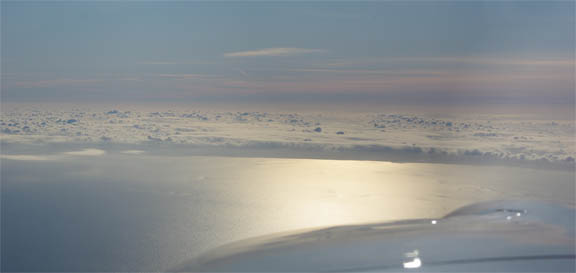
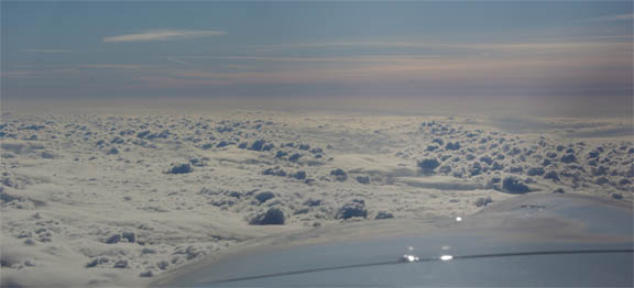
Much of the return flight was under a thin cloud layer which was probably around FL160
The temperature at FL140 was -20C and sure enough the elevator trim was found to be frozen within 15 minutes of levelling off. Fortunately the autopilot worked fine (because no trimming was required in level flight) and had suffered no damage. Earlier, the pitch trim servo (which costs $2000) must have been running against its torque-limiting clutch. To avoid another "trim failure", the autopilot was disconnected for the descent.
Most unusually, London Control cleared us to contact Shoreham while still descending through FL130, a few nm south of Lydd. As the base of Class A is FL055, this was a real suprise. Evidently they were having a pretty relaxed time... they did not even ask for a minimum descent rate.
Both flights were tracked using the EuroFPL aircraft tracking facility which accesses a feature provided by Eurocontrol. Some example snapshots can be seen in this writeup. This is a very nice feature which enables friends/relatives to keep an eye on where you are, although a text message from a satellite phone can be more useful to someone waiting for you.
As is usual in European low-airways IFR, no other aircraft were seen anywhere near the cruise level.
On the day, this trip would have been fine under VFR.
All ATC were entirely professional and helpful.
Apart from the frozen elevator trim the aircraft performed perfectly. Some notes on Socata TB20 ownership and operation are here.
Elevator Trim
This was the first time ever that I had a frozen elevator trim. Knowing the TB20 elevator trim arrangement, and the very limited movement at the trim wheel when it was frozen (about 5mm) the virtually certain cause of the problem was a frozen cable spool assembly. This is right at the back of the aircraft, almost inside the tail cone. It is not exposed to the airflow but would, in time, cool down to the outside air temperature. As it was established that the trim servo had not died (by watching for any trim wheel movement when the electric trim was operated) the only other places where the trim cable could be "gripped" sufficiently effectively to stop it moving are well forward, in the cockpit, and not subject to the outside temperature.
The aircraft had just come out of the Annual (for those who know me: this is not the company where I am hangared) but enquiries were inconclusive. Since this type of defect makes high altitude flight - VFR or IFR - unsafe and makes a TB20 as useful as a chocolate teapot, the mechanism was dismantled at the earliest opportunity, by myself with an FAA A&P engineer familiar with the aircraft type. It's not a difficult job but it takes a number of hours as the whole assembly has to be removed, stripped down, washed, and reassembled with copious amounts of the correct grease.
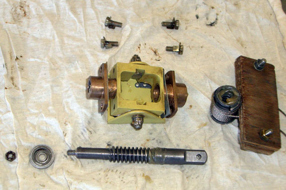
The above shows the cable spool assembly just before it went back together, with more grease (not shown). It's a competent piece of mechanical design but taking it apart is not a job which most maintenance companies will do routinely.
Pilot: FAA CPL/IR, approx 1100 hours.
Any feedback, reports of dead links, corrections or suggestions much appreciated:
Contact details
This page last edited 26th March 2010
