Background
The history of "aviation weather" goes back some decades. In recent years it has been revolutionised by the huge amount of freely available weather data out on the Internet and, as a result, the weather sources which most private pilots learnt about during their training lag well behind what is now available.
The Internet has also changed which weather services are popular. The old-style wide-area forecasts such as AIRMETs and SIGMETs are still taught and examined, and in FAA-land have a bit of a history of carrying a strong legal weight, but very few pilots seem to use them nowadays.
There are also widely disseminated misconceptions as to which kinds of "aviation weather" are "official", "authorised", etc. There may be countries whose national aviation law requires the acquisition of specific weather data but I am not aware of one. In the UK and in the USA, nothing specific is prescribed. The pilot merely needs to obtain (paraphrasing) sufficient information for the safe conduct of the flight. This enables a pilot to safely use a much wider range of weather data than what is available according to the official training material.
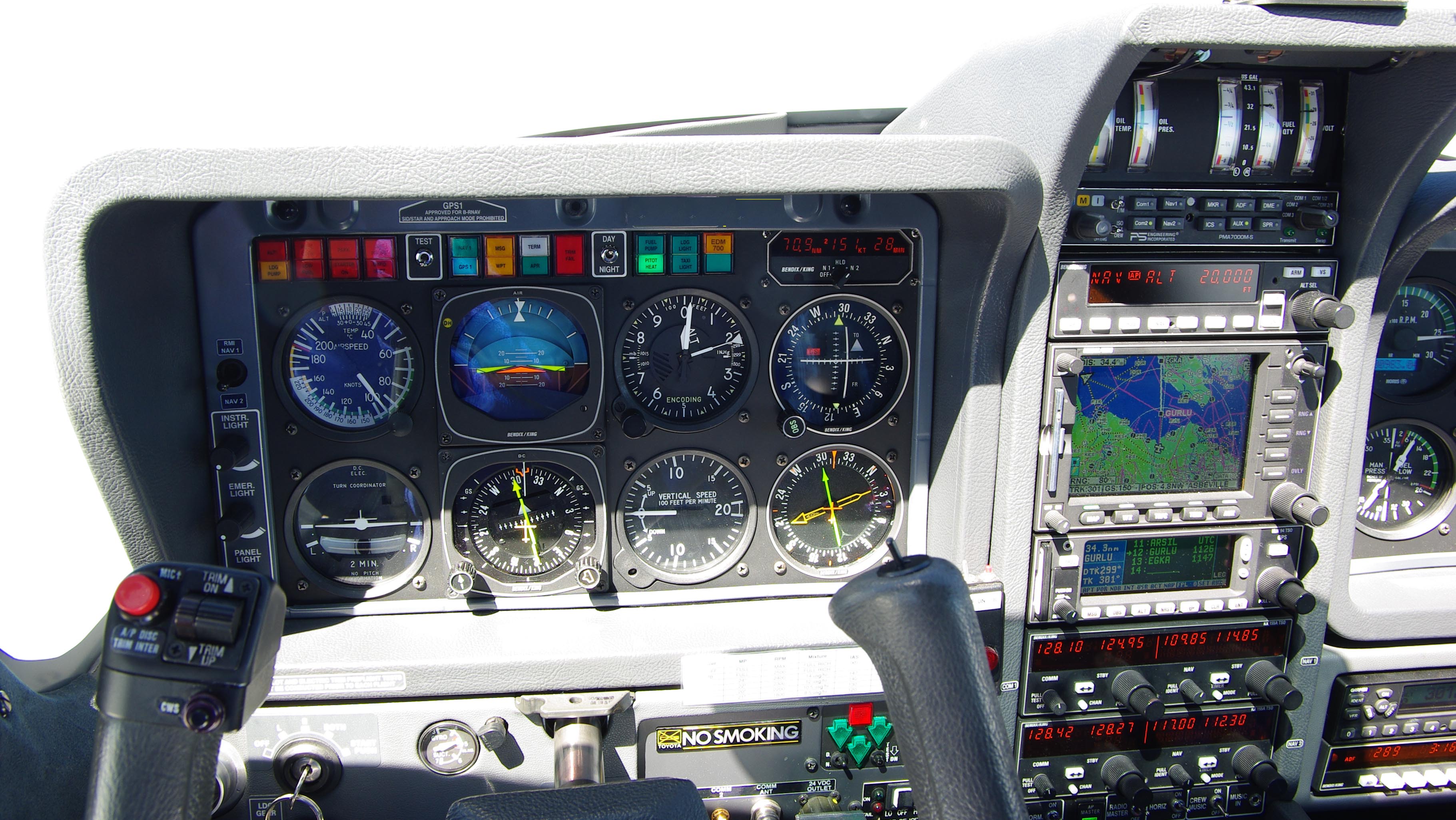
Unless indicated otherwise, this article is written for the pilot of an aircraft which is not comprehensively de-iced and has an operating ceiling below 20,000 feet. The writer flies such an aircraft: a Socata TB20GT with a TKS de-iced propeller.
The context here is flight on Eurocontrol airway routes under radar control. This requires the full IR. This article does not attempt to address IFR flight using the UK IMC Rating, which is normally done in UK Class G, occasionally asking for a Class D transit. In this case, icing is rarely an issue except in the winter, but the pilot is rarely able to climb to VMC on top due to the low base of controlled airspace (mostly Class A) combined with the lack of an enroute IFR clearance. This kind of flying is often seen as the most difficult kind of IFR especially in the winter where the pilot is trapped in icing conditions at low enroute levels.
This article was originally written in 2009 and has been updated since. A couple of things have changed: the Meteoblue site seems to have vanished and been replaced by a couple of 3D GFS weather plotting sites (OGIMET GRAMET and Autorouter GRAMET), and the notes on mobile internet are not current due to the speed at which that business moves.
Private Pilot Weather Requirements
The best known weather data comprises of aerodrome-vicinity actuals (METARs) and forecasts (TAFs). METARs and TAFs are produced under ICAO obligations by each national weather authority and are freely available on the Internet for every significant airport in the world, and can also be obtained from pilot briefing facilities at most major airports. The UK PPL pilot is also taught to consult Met Office Forms 214 and 215 which show UK winds aloft and a surface analysis.
The above is OK for VFR flight below cloud; in fact a VFR-only pilot could quite safely brief from just the TAFs and METARs (a string of enroute airports, plus the two ends and the alternate) and provided he sticks to some straightforward rules (one example might be: 1hr before and after the planned time, the cloudbase needs to be 1500ft AGL and the visibility better than 5000m) he will be fine most of the time. Of course, the majority of flights planned some time in advance will end up being scrapped but that is a feature of "VFR-only" flight...
The next stage is VFR flight which exercises the VMC-on-top option. A UK PPL holder cannot do this unless he holds the IMC Rating or an Instrument Rating. Interestingly, I am advised in writing by the UK CAA that the IMC Rating is valid for this purpose worldwide, unless locally prohibited. In this case, the weather planning is amazingly similar to a fully IFR flight (below) because the objective in IFR is also to remain VMC on top when enroute, though of course there is the additional requirement for VFR conditions at the two ends and the alternate and this requires a very careful appraisal of the weather there. However, since a great deal of full-IFR flight happens to be wholly in VMC, this leads to the amusing observation that if VFR controlled airspace transits were everywhere as predictable as ICAO airspace classification implies (everywhere except Class A is good for VFR) there would be much less need for an IR for long flights across Europe.
Then we have IFR...
IFR Strategy
IFR is the holy grail of pilots flying distances because one can penetrate IMC if required, there is an implied whole-route clearance (controlled airspace and national boundaries become largely irrelevant, resulting in much less stress) and the flight has the automatic use of instrument approaches. Many non-instrument pilots think that instrument pilots fly around in IMC but nothing could be further from the truth; instead one can hilariously observe that the very hard to get IR enables one to spend 99% of one's flight time cruising in sunshine, wearing a T-shirt and shorts, with ATC doing nothing but helping along the way! However, there are several prices to pay for the membership of this highly organised and predictable flying club, and one of these is a need for a more detailed weather picture - due to a number of factors:
- IFR flight is done under tight radar control; ATC allow deviations "due weather" but getting the clearance can take time especially if a climb or descent is requested. ATC will almost always accommodate your weather avoidance requests, but your emergency authority is there to be used if the alternative is penetrating weather that endangers the flight.
- the Eurocontrol airway system does not support the idea of flight below the airway MEAs (minimum enroute altitudes) even where terrain clearance or conflicting traffic are not an issue
- the airway MEAs (or, more practically, the levels at which traffic is supported by the IFR / ATC system) are mostly above FL070
- the SAT (static air temperature) at FL070+ is usually freezing (in northern Europe, even in the summer) so any IMC carries a risk of structural icing
- the aircraft usually has little or no anti-ice equipment
- the aircraft usually has no radar so cannot see embedded CBs etc if flying in IMC (a stormscope is a good piece of kit but considered not sufficient by many)
- the aircraft operating ceiling is not high enough to get above frontal-weather cloud tops
- flight in IMC can be turbulent, and frightening for passengers who do not understand what is or is not safe
- flight in significant turbulence needs to be below Va (i.e. slow) especially if in IMC
In the absence of good preflight planning, and if one gets "behind the aircraft" when airborne, it is quite easy to get cornered into a dodgy flight in freezing IMC or in something worse. This is irrespective of how good an instrument pilot one may be, and does not relate to the navigation/autopilot equipment. And by the time one has decided that the ice is building up enough to be a problem, one has lost enough of one's climb performance to climb above the clouds... Slow or poor cockpit decisionmaking does not help but nothing can be done about aircraft performance. European ATC have no access to enroute weather data and will have no idea that the blip on their radar is in serious trouble until it is urgently asking for a descent to below the 0C level. If this happens above significant terrain, or one flies into an active CB especially at too great a speed, it could be fatal and this has happened many times.
The smart way to play the game - at least this is what I try to do - is to keep all the options well open as far ahead as possible:
1) Climb up decisively to VMC on top;
2) Remain VMC on top for the whole route. Keep the decision-making firmly in the cockpit and climb further as required to remain VMC; this is generally easy because one can see 50-100nm so the reduced climb performance of non-turbocharged aircraft in the FL100-FL200 region is not a problem. With convective clouds, a climb may not be an option so a request for a left/right heading change is done. Conversely, if one filed for say FL160 and the tops turn out to be much lower or there are no clouds, one can ask for a "stop climb" and fly at a level which gives a good speed, economy or even avoids the use of oxygen (FL100 is popular for this).
3) ) Remain VMC on top until the last possible moment. The gotcha here is extended ATC holding after a descent into freezing IMC, but holds are extremely rarely assigned to GA flights and at the only times I have got them they were at or near my enroute cruise level.
At each stage, as always in aviation, there must be a plausible escape route: from the climb one can descend back down (and scrap the flight) if VMC is not reached; enroute one can turn back if too-high IMC is encountered in all useful directions; at the arrival phase one is descending anyway.
Some pilots will disagree with the above rather conservative strategy - which for me results in the scrapping of about 25% of preplanned flights - reporting that extended flight in IMC does not usually result in significant ice accretion, that a stormscope is sufficient for avoidance of hazardous weather, and that cancelling a flight, or turning back due to cloud tops being above the operating ceiling, is excessively cautious. I choose to fly VMC enroute for the reasons given above, but have to admit that this approach is feasible because my operating ceiling is 20,000 feet (21,000 if light and the temperatures are not too warm) which does the job most of the time. With lower aircraft performance, I would be forced to accept a greater perceived level of risk.
Conversely, with higher performance, things get a lot easier. At the top end, a jet with an operating ceiling of 40,000ft, de-ice, weather radar, a climb rate of +5000fpm and - on the big ones - CAT3 autoland doesn't need to know very much about "GA weather". Its pilot needs surface winds, temperatures and visibility, and a few other bits. Almost every scenario is a GO and they deal with whatever weather is encountered, using radar in terminal areas and flying above most of it when enroute. Even with turbocharged piston aircraft, the higher TAS figure (say 200kt) produces significant airframe heating which eats into the temperature band in which supercooled water exists (in non-convective cloud, typically 0C to -15C) and consequently less ice gets picked up. Some turbocharged piston pilots look at the SigWx and if no CBs are forecast, they fly.
Risk management in aviation is a very individual thing...
Weather Source Overview
METARs
These report actual aerodrome-area surface conditions and are valuable just
before departure, not only for checking the actual conditions but also for getting
an idea of which way the conditions are changing and for establishing whether
the forecast (the TAF) is accurate.
TAFs
These are aerodrome-area forecasts of the surface conditions, and usually include
useful data on the cloudbase and the type of cloud including hazardous conditions
e.g. CBs. TAFs for enroute airports may superficially appear to be of
limited value to the IFR pilot but a forecast of +TSRA is highly relevant because
the stuff will have tops well above the operating ceiling of any piston aircraft,
and such data may indicate the predicted timing of a front passing through the
area.
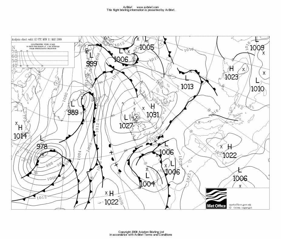
MSLP
This chart (example - also called "Surface
Analysis") shows surface pressure isobars, and most versions of it include
the positions and types of fronts. The isobar spacing indicates the wind strength
and direction. Gleaning additional information requires expert knowledge but
it is a very easy chart to use for a GO/NO-GO decision; a simple strategy of
taking one look at it and not flying through any front will avoid the vast majority
of hazardous weather.
Ascents/Tephigrams/Soundings
These (example) are specialised data presentations;
forecasts extracted from the 3D computer models of the atmosphere, which are
used by professional forecasters. Although the axes on the different chart types
can be scaled in different ways, the three names are largely interchangeable
in terms of value to a pilot. There is a great deal that can be gleaned from
these charts: cloudbase, cloud tops, stability (the likelihood of heavy vertical
development e.g. CBs) and much else if you are an expert who does this for a
living. However, the essentials like vertical cloud extent and temperatures
can be read directly off the chart. The "METAR" (actual data) version
of this chart is produced from the ascent of a baloon probe, launched
generally at 0000Z and 1200Z at a number of locations around Europe, and this
can be very useful in certain conditions e.g. where the air has obviously not
moved much between the ascent time and the flight time. The ascent data can
be found here (select
Europe - Skew-T) and here.
Other Products
There are countless websites which present GFS data in various graphical forms.
I use this NOAA one which
offers a variety of presentations including soundings. One of the more interesting
ones is Meteoblue which can plot the
weather along a straight line route. There are also more traditional things;
for example the SigWx but I have lost a lot of faith in that one since some
spectacularly wrong forecasts revealed that it shows hazardous weather only
and does not give a real indication of where IMC / cloud tops might be.
In Europe, and particularly in the UK where the UK Met Office sells its more advanced weather data to specialist commercial weather providers, it's not easy to get the more advanced data one needs. Fortunately there is a freely available worldwide weather model run by the USA: Global Forecasting System (GFS) which in the tradition of much American taxpayer-funded material is accessible via many free websites and the data can be viewed in various graphical presentations. All the more advanced weather products mentioned in this article are derived solely from GFS. A lot of data which the UKMO keeps to itself is actually passed (under ICAO obligations) to other countries and some make it available online :)
IFR Weather Data Acquisition
My weather planning strategy involves getting detailed weather for the terminal areas (departure, destination and alternate airports) plus cloud tops data enroute. The flight would be scrapped if any of the following are true:
1) Unacceptable weather in the terminal areas e.g. a lot of freezing IMC to climb through, embedded CBs.
As to what is "unacceptable weather", that is a whole big debate... I would climb or descend through several thousand feet of stratus below 0C, provided the icing escape route was preserved by the 0C level being at least 2000ft above the MSA.
2) Enroute, the tops of any "organised" IMC are likely to exceed the aircraft operating ceiling.
This is less of an issue than might appear. To date, I have not scrapped a single flight due to this except in frontal conditions, or large scale airmass thunderstorms. Once airborne, I have never had to turn back or divert. As regards "organised IMC" an example might be stratus tops at 5,000ft, with a PROB30 TEMPO forecast of CBs somewhere downroute; these can be visually avoided with ease but obviously only if one is not sitting in the IMC.
Legal Issues
The issue of "known icing" has been subject to different legal interpretations over the years, and I will keep this very brief. Under FAA rules, a mere area forecast, or visible moisture below 0C, do not alone constitute known icing. This is just as well, since the FAA rules were written for American aviation weather services which are vastly superior to European ones. Under JAR/EASA there is no "flight into known icing" concept - in an aircraft without certified ice protection you must exit icing conditions if you encounter them, and you must plan flights sensibly for such a possibility.
An Example
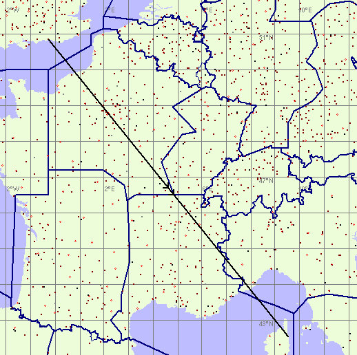
The following planning example shows a departure and arrival in relatively benign conditions, and a enroute section which contains some IMC but is done - typically of IFR flight - VMC on top. The flight, 1st May 2009 and around 1200Z, is from Shoreham, UK (EGKA) to Bastia, Corsica (LFKB)
In reality the flight would not be a straight line but an airways route would not be far enough off to matter for this purpose.
The following weather snapshots were done around 3 days ahead of the flight date, and were selected to represent a relatively common IFR flight scenario.
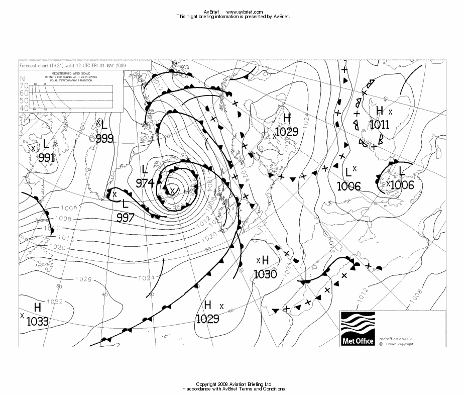
The first thing is to look at the MSLP chart
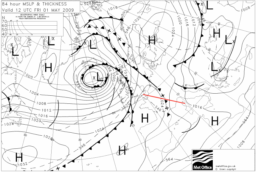
which (route shown in red) most importantly shows nothing exciting at the two ends, and a somewhat half-baked cold front halfway along the route. One big question is: how bad will the conditions be where that front is lying?
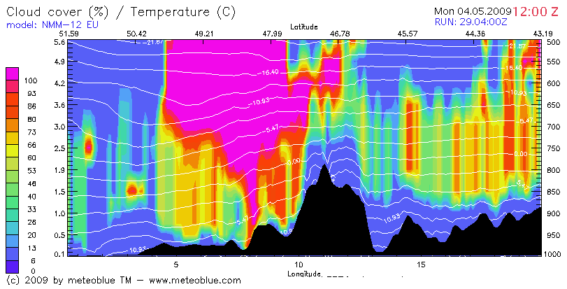
We start with Meteoblue and the following screen config
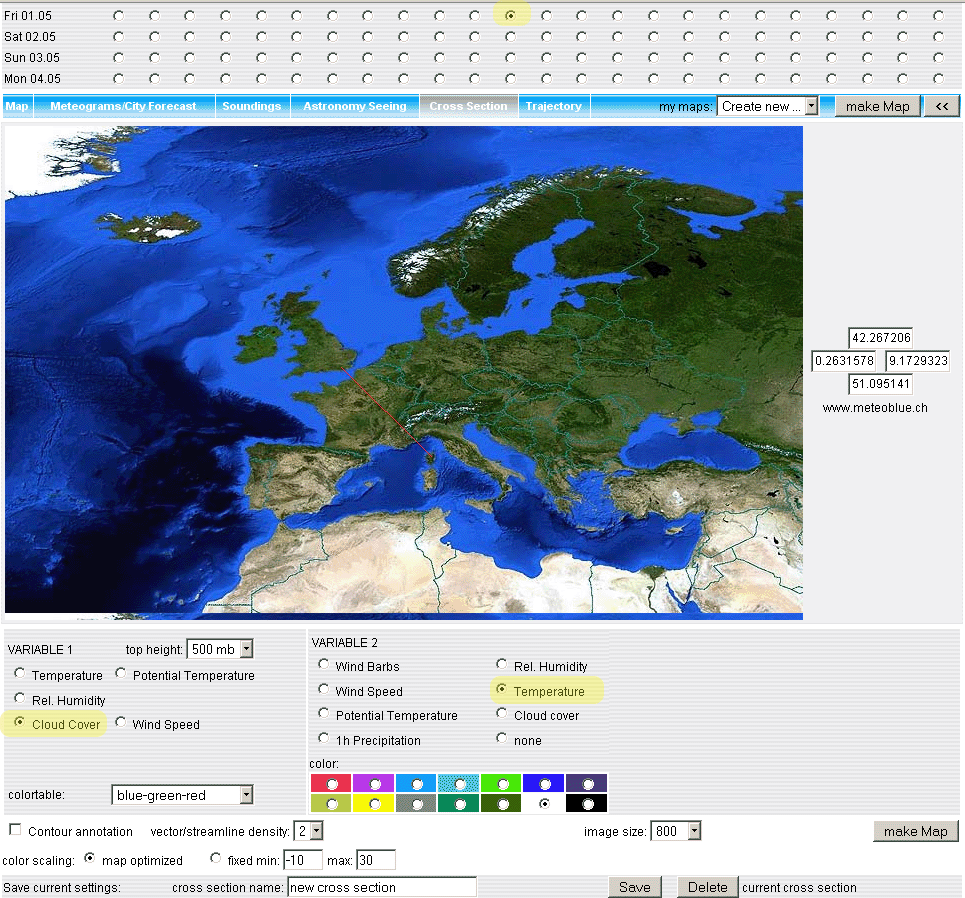
The essential settings in the above screen are highlighted in yellow. Due to the peculiar way the software works, it is vital to select the "cloud cover" and "temperature" as Variable 1 and 2 respectively! The thin red line is dragged across the map to represent the straight-line track for this flight.
Clicking on Make Map produces the following
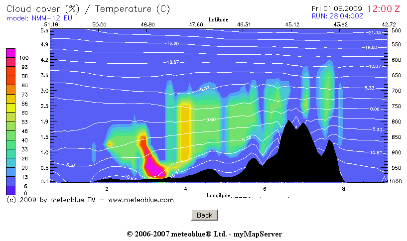
which looks reasonable relative to the MSLP chart.
One needs to be a little careful here because that MSLP chart came from Avbrief and thus derives from the UK Met Office model, while everything else comes from the US GFS model. At short time ranges, and with clearly moving weather, the two normally agree reasonably, but differences in timing (and thus the position of fronts etc) are common.
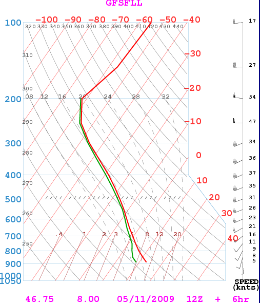
One can see that there will be some IMC to around 700mb or 3300m (around FL100). In this case, one would file for around FL150 which is within the capability of most reasonable IFR touring aircraft.
One should verify the above Meteoblue forecast, at relevant spots along the route, by using another GFS site, and my preferred one is NOAA. In the airport code, enter LFSD (which lies somewhere around where that front should be around 1200Z) and from the pulldown menu which then appears select Sounding, 0-84hrs. This leads to the config screen for the Soundings, and you select a 24hr animated output commencing 0000Z on the day:
Out of the resulting animated output, the two least favourable snapshots are indeed around 1200Z and these are shown below
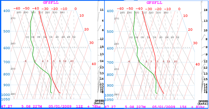
The two lines are the dewpoint and the temperature. You can expect IMC roughly according to the following rules, by looking at the temperature spacing between the two at any given altitude:
<1C means 7-8 octas cloud
1-2C means 6-7 octas cloud
2-3C means 4-5 octas cloud
3-5C means 2-4 octas cloud
>5C means clear
On the above example, it is apparent where the two lines approach each other and one would expect the cloud bases around 3,000ft and the tops gradually dispersing around 8,000ft, and blue skies above that. Very roughly speaking therefore (which is the best one is going to get in weather forecasting) these charts agree with the Meteoblue profile.
The 0C level is incidentally also roughly around 8,000ft (the blue 0C line intercepts the temperature line at 750mb) though this is not important because the idea is to fly VMC on top.
Now, let's look at the forecast weather for the departure and destination. The obvious place are the TAFs but these do not go very far in time and for further ahead one can get data for a specific point from the NOAA site too, this time specifying the airport ICAO code (EGKA or LFKB) and using the Meteogram instead of Sounding, and again choosing the 0-84hrs. The config screen looks like this
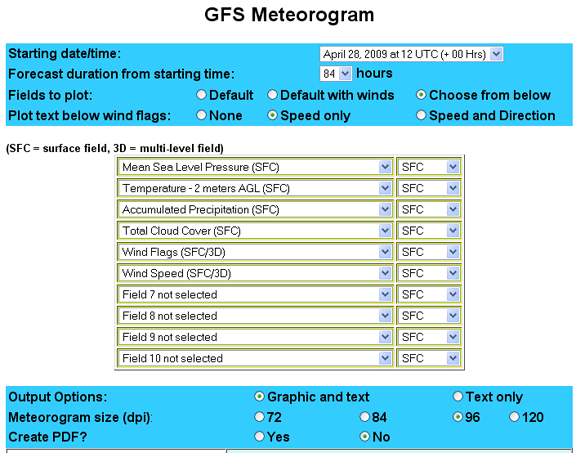
One can select many different parameters from the pulldown menu although one cannot mix 2D and 3D ones... The output in this case is
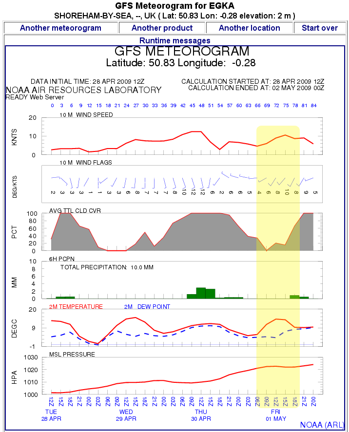
which shows fine weather (highlighted in yellow) for the departure on Friday 1st May. The corresponding plot for the destination (use the Another Location option for this, to avoid having to re-select the pulldown menu options) is
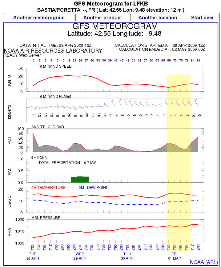
which is also good.
In this case, on the basis of the above advance planning, it's a GO.
However, every pilot will get up to date weather shortly before the flight. There are a number of options:
- METARs for terminal areas, and airports enroute. If you see OVC006 and +TSRA then you are looking at IMC with embedded CBs.
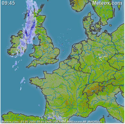
- Weather radar. The most popular site is Meteox. I have found that if this shows solid white then there are going to be conventive tops to perhaps FL250 and a lot of IMC all around. Red is a no-go; it is a TSRA.
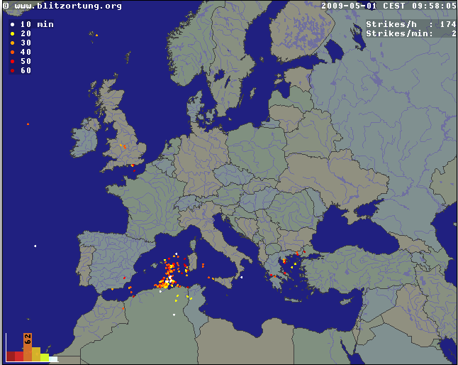
- Sferics. These are lightning maps, which will show CB activity. I would not fly anywhere where the map is like an xmas tree.
Post mortem: The TAFs taken the evening before were
TAF EGKK 301703Z 3018/0124 17006KT 9999 SCT028 BECMG 3022/3024 7000 PROB40 0100/0108 3000 BR PROB30 TEMPO 0103/0107 0700 FG BECMG 0107/0109 9999 TEMPO 0107/0110 BKN010 BECMG 0111/0114 23010KT BECMG 0122/0124 6000 BKN008=
TAF LFKB 301700Z 3018/0118 30010KT 9999 FEW040 TX20/0114Z TN12/0103Z=
with neither being wildly out of line with the long range data from NOAA. The MSLP improved over the original one, with the front having moved off the route, and the 1200Z SigWx shows nothing on the route either.
On the morning of the flight, the Meteox image was clean and the sferics image showed CB activity west of Corsica but the air movement was to the west there so this was not a threat.
General Tips
The forecasts are often much bleaker than the actual weather; not least because IMC is much more of a "statistical" thing than the data might imply. This is why actual data, be it METARs, weather radar or sferics, has such a great value. Yet almost nobody on the GA scene knows about the last two, and I can think of fatal accident flights which would have been scrapped had the pilot acquired this data.
ATC are usually more likely to accommodate - "due weather" - a rapid descent than a rapid climb, so being too high is better than being too low. Therefore, file the flight plan for the highest level you can fly at; say FL180 and if during the climb you find the general cloud tops to be FL090, ask for a "stop climb" at FL100. This will reduce the oxygen requirement and may result in better groundspeed (MPG) if there is a headwind because winds tend to be stronger higher up. Whereas filing the flight plan for FL100 or lower could result in a poorer (longer) route or - especially in the UK - in being accidentally dropped out of the IFR system altogether.
A different reason for avoiding a "low level" filing (basically anything below FL100) is that - in the UK - it can cause the departure ARO to misinterpret the fully-IFR intention of the flight plan with the result that one is not admitted into the IFR enroute system and ends up pushed down into the "Class G ghetto", with the Eurocontrol flight plan automatically binned and with no way to get back "upstairs".
If departing from a Class G airport, if the local conditions are poor in the intended direction but the weather is OK (patches of blue sky showing through, etc) for a climb in a different direction, perhaps after a few miles, depart in the "good" direction and climb high enough to see what is going on from above, before calling up the IFR controlling authority (e.g. London Control). Whereas if you called them up immediately after departure, their initial climb instruction would take you straight into IMC with unknown contents.
In Europe, it is very rare for non-convective cloud tops to exceed FL160. The highest I have ever seen was FL185. Avoiding the fronts shown on the MSLP chart is the simplest and the most offective trick of them all!
Fronts
For a conservative pilot, frontal weather will be responsible for the vast majority of cancellations. Do not be afraid to cancel. Fronts move along (cold ones move faster and more decisively than warm ones) and PROB90 the following day's weather will be fine. Often, for fronts near the terminal area(s), a few hours' timing change does it nicely. What illustrates this well is a survey done in the USA of fatal accidents in which weather played a major part; in the majority of cases the wreckage was found the following day in perfect VFR conditions...
One can fly through fronts, however.
For fronts encountered during the enroute phase, the chief issue is the aircraft operating ceiling because the idea is to be VMC on top. Warm (or occluded) fronts are the worst; they tend to be solid IMC with a very low base (e.g. OVC005) and often with tops in the FL200-FL250 range, plus anything that sticks up (e.g. embedded CBs). This is above the capability of nearly all piston aircraft. The pressurised PA46 can do it, as can many unpressurised turbocharged types albeit with a great deal of oxygen used. Cold fronts are "easier" because they tend to have less "organised" IMC and the CBs (which cannot themselves be out-climbed) can be avoided visually. In Europe, it is rare to find solid walls of CBs.
Fronts in the terminal areas are the most dangerous because one might be in IMC and the options are severely limited. This is the province of aircraft equipped with radar, de-ice and high performance.
Of course, there are fronts and there are fronts. A cold front sitting right over the departure airport could be self evidently just a few TCUs hanging around quite some miles away, in which case a safe departure is obviously possible.
One can also get an idea of the forecast severity from the TAFs and this is true for both terminal and enroute-airport TAFs. It is possible to work out atmospheric stability (and thus the probability of significant lifting activity, resulting in CBs etc) from the temperature lapse rates in the Skew-T charts but this is what professional forecasters do for a living all day long; if the TAFs were produced by a forecaster who is even half competent, they will contain warnings such as TSRA if the appropriate information exists in the Skew-T data.
Additional reading is here and here and a google on "skew-t" or "tephigram" yields vast amounts of variously heavy material.
Convective tops are near-impossible to forecast and employing the above methods (Meteoblue etc) merely results in something like this
which is on the face of it impenetrable (due to operating ceiling) by any piston aircraft in common use, but would probably be OK if one was radar equipped and seriously de-iced. The flight would be in IMC, in icing conditions, for hours, so toughened-up passengers would be preferred.
SigWx Reliability ?
Here is a good example of why the SigWx is not safe to rely on (alone) as a predictor of a lack of hazardous weather: Take this Airbus flight from Kavala LGKV to Gatwick EGKK, 11/5/2009, which crossed the Swiss Alps around 1200Z.
The SigWx shows no significant weather in the area above FL140 (Area #11). On that basis, one would have probably flown.
The MSLP chart shows the tail end of a warm front, further north of the Alps. Nothing serious there...
The Meteoblue cross-section of the approximate route (plotted EGKK-LGKV left-right) is a very different picture:
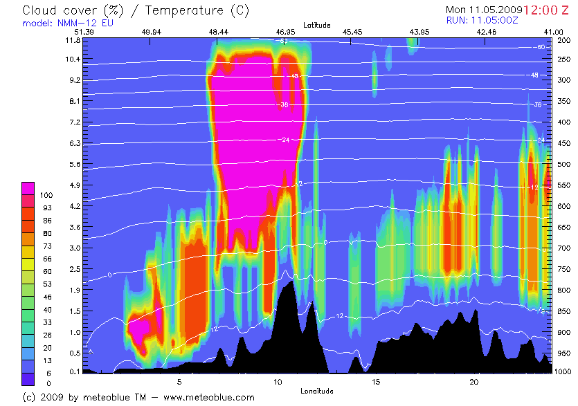
Notice the vertical axis going up to 200mb - the IMC is up to about 35,000 feet.
The NOAA/GFS forecast sounding for a representative spot along the route backs up the Meteoblue picture, with solid IMC all the way up
Looking out of the window, at a verified FL380, one could see solid IMC to around FL250-300, with lots of convective activity embedded within it. It would have been an extremely rough flight, with no way to outclimb it, and no way to descend out of icing because the 0C level is somewhere underground - the mountains in the area are a lot higher than the Meteoblue profile shows and they were covered in snow.
Both the Meteoblue picture and the NOAA sounding were "forecasts" but were run a few hours after the actual flight so one would expect them to be fairly accurate, as indeed they are. No actual soundings (baloon ascents) can be found for the specific area.
Why is the SigWx so wrong in this case? No idea but I have seen this before. I don't suppose anybody particularly cares because the SigWx is a weather product for commercial aviation, and a jet with an operating ceiling of say FL400 is not going to care what the enroute weather is provided they can climb above it - which they practically always can. The probable lesson is to consult multiple sources, and proceed with caution.
Oxygen
From the altitude figues seen in this article, it should be obvious that unpressurised flying without oxygen is going to be extremely restrictive because one chucks away the most useful portion of one's operating ceiling even before leaving the ground. Oxygen, with cannulas used in most cases, is not a big deal. I have a couple of articles on the subject: here and here.
Weather Enroute
ATC can supply weather (METARs) for specified airports - if not too busy. There are VOLMET broadcasts on selected VHF frequencies. For high-end aviation there is satellite internet on which you can obviously get anything you want. I have done a relatively successful project on the use of a satellite phone for this purpose.
Mobile Internet Access
This is a de facto necessity for any serious travelling pilot, whether VFR or IFR. Over the past few years, preflight activities (weather, Notams, flight plan filing) have moved more or less wholly to the Internet and while most things can still be performed using the traditional airport briefing facilities, this is at best a waste of time especially at an airport where no English speaking persons can be found. And almost no airport briefing office will have enroute Notams, or any weather data beyond the standard METARs, TAFs, MSLP, maybe SigWx.
Every modern laptop has built-in WIFI but the days of free (or unsecured and unintentionally available) WIFI are long gone. Even a cafe WIFI will need a password which you get when you buy a drink. In hotels it often doesn't work properly throughout the room. Its short range means that even if it is available at the airport cafe, it will be out of range if you have to do a last-minute replan while outside on the tarmac and trying to avoid going back indoors, having to again clear Customs, etc.
This is where 3G/4G comes in, and there are multiple ways to make it work. There are some laptops with a built-in 3G modem but while this approach is neat and avoids "gadgets", it can result in much higher costs if one frequently flies abroad: the 3G modem is literally a mobile phone and thus requires its own SIM card. In most "private pilot" usage, this SIM card will be used only sporadically and most pilots will obviously choose a prepaid (PAYG) tariff. All the network operators charge exorbitant rates for roaming (in general, "roaming" means any usage outside of the country where the SIM card was issued) 3G data on PAYG. Topping up a PAYG SIM card can also be a hassle, especially as often there is no easy way to find out how much money is left on it, without extracting it from the innards of the laptop. Therefore, a more cost-effective approach is to use one's own mobile phone as an external 3G modem, connected to the laptop using Bluetooth or WIFI; this makes use of the phone's SIM card which is likely to be on a contract tariff, and contract tariffs have much lower data costs than PAYG.
The more upmarket "business user" contracts come with huge amounts of "free" data allocation, even when roaming, and the prices have come down. Currently, I get 3GB/month on a Vodafone contract costing £12.70/month plus VAT. This allowance is available throughout Europe for £3/day while roaming. The phone (Samsung S7) has a WIFI hotspot feature to which the laptop (or anything else e.g. a tablet) can connect and this has made looking for WIFI redundant.
WIFI obviously works only on the ground anyway. 3G can sometimes be found to work up to around 2000ft when airborne but is highly unreliable at best. A truly airborne Internet data solution requires a satellite phone; this can be made to work acceptably but a reliable implementation involves a permanent rooftop antenna to be installed in the aircraft. However, 4G (also called LTE) has improved this situation and it is often possible to get brief moments of connectivity up to 20,000ft - especially if flying in or near mountanious areas where the cell towers are high up. Because 4G establishes the internet connection (DHCP, etc) about 10x faster than 3G, one can download weather, email, etc even in the brief moment during which the connection exists.
Mobile Internet delivers many time-saving benefits. You can get weather, Notams, contact airports regarding PPR, file the flight plan, as well as do all the traditional Internet tasks e.g. email.
Fax is regarded by many as outdated but remains occassionally useful for airport PPR requests or notifications, not because the airports are not on email but because the email address is unpublished, is wrong, or nobody reads the emails. In terms of technology and management attitudes, many airports are still in the age of Humphrey Bogart and DC3s, with the major concession to technology being a fax machine, hopefully with some paper in it. With some fax software, one can transmit faxes directly from a laptop with the aforementioned 3G modem but receiving faxes requires the laptop to be switched on permanently which is usually impractical; most mobile fax users therefore prefer to use email2fax and fax2email services which avoid a great deal of the technical hassle of setting up faxing and merely need Internet access. An overview is here. However, I have not sent a fax in years - except when trying to contact some airport which is simply not communicating at all.
Last edited 26th June 2016.
Any feedback, reports of dead links, corrections or suggestions much appreciated:
Contact details
