This article describes an IFR trip from Shoreham to Ljubljana, Dubrovnik, Tirana, Corfu, and back via Venice.
It is written to highlight the additional capability which an Instrument Rating provides, in the context of a single engine unpressurised aircraft and a pilot who is already instrument capable; for example holding the IMC Rating.
A glossary for non-aviation readers is here.
Objective
Geographically, this trip was similar to previous trips to our previous Crete and Santorini trips: to visit a number of interesting locations and to enjoy the views from the air.
The stops were chosen to be interesting enough so that if we were stuck due to weather it would not matter. Also, one has to choose airports that have both Customs and Avgas; this is harder than one would expect.
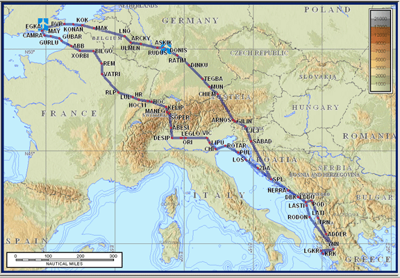
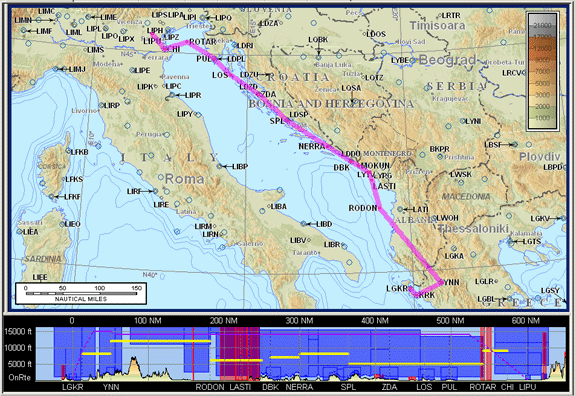
The above map shows the full extent of the flight planned route, on airway routings validated by the Eurocontrol CFMU website.
A recently acquired IR opened up the flight planning options with legal instrument flight at whatever level was required to avoid the weather. The Crete and Santorini trips from previous years were planned and flown as IFR but had to be filed and flown under VFR.
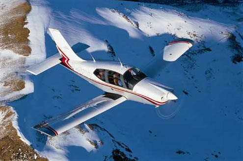
The aircraft is a Socata TB20, with a range of about 1200nm, a ceiling of 20,000ft, 155kt TAS at 10,000ft at 60% power. Main navigation equipment is a KLN94 IFR GPS with a KMD550 multifunction display. The aircraft is on the N (USA) register and the pilot has an FAA PPL/IR with about 700 hours total time. It is an ideal aircraft for this type of trip. It's a 4-seater with excellent load carrying capability but with 2 people (myself and my partner Justine) and enough stuff for 2 weeks one is not far short of being full in volume if not weight.
VFR versus IFR Capability Comparison
This is just a summary of the two types of flying rules. I am not writing on how and where to get weather, etc. Please note this is not exhaustive and some of the rules differ around Europe.
VFR Legal Requirements
One must be clear of cloud at all times (in essence). A UK PPL holder also needs to be in sight of the surface, worldwide, unless he holds the IMC Rating or an IR in which case he can fly above an overcast layer in any airspace where this is not prohibited. He also cannot depart or arrive at an airport which has published VFR minima and the weather is below these. He must also remain outside controlled airspace (CAS); any entry into CAS (which for VFR is Class B,C,D) requires an ATC clearance.
VFR Practice
Some pilots bend the clear-of-cloud rule which is obviously unenforceable while enroute but the others are strict and usually obvious in their violation. The VFR departure requirement in particular can keep one stranded for ages. One can usually get a CAS transit (particularly outside the UK) but it's never guaranteed. Even if one can legally fly out of sight of surface, the natural tendency in VFR is to fly below the clouds (to avoid getting snookered at the destination) and this introduces a terrain clearance issue with scud running or even having to land and wait for an improvement. It's difficult to fly long routes, say 500-800nm, under VFR because it's hard to ensure that the maze of legal requirements, weather, terrain, CAS transits, will be met over such a long distance, with the flight spanning perhaps several weather systems. Flight above clouds can be a great solution and that is how I did all my previous long trips, but one cannot climb into Class A; ATC could also refuse any requested level if within CAS (in practice they are very accomodating if the climb is "due weather") and finally you have to be very sure of being able to land under VFR (which requires a really good look at the destination weather). It's a paradox that the full legal privileges of VFR cannot be exercised without instrument navigation and other flight capability which is not trained in the PPL syllabus. A competent instrument-capable pilot with a confident radio manner and a well equipped IFR aircraft can go a long way with VFR but the inability to descend through cloud and fly an instrument approach is a major problem. The only way to do it legally is by declaring an emergency.
VFR Flight Planning
This starts with obtaining the VFR charts and working out a route which falls outside CAS and which - for navigation options - uses navaids as much as possible. The route will normally be flown with a GPS but a VOR/DME/NDB backup is always worth having. The VFR charts are normally paper ones but the Raster Charts add-on for Jeppesen Flitestar offers an alternative allowing en-route chart sections to be printed out before the flight.
Next, you work out an alternative (usually much easier) route which takes advantage of any CAS transits you can get while airborne. Transits cannot usually be arranged prior to the flight although one can phone up various ATC units en route to discover their attitude to granting transits - the replies range from a totally noncommittal UK or Italian one, to "Well of course Sir, Class C is fine for VFR" from Belgium. Some units will tell you about preferred routings.
Next, you get the notams in the form of a narrow route briefing, to check there are no airshows etc enroute. A full ICAO flight plan must be submitted if crossing national boundaries (some countries have additional requirements).
Next, you need VFR airfield charts for the VFR joining/circuit details; for UK only one can use the Pooleys or similar but for abroad one probably ends up buying a pile of the heavy, expensive and often inaccurate Jeppesen Bottlang guides. On a 2004 VFR flight to Crete I carried 20-30kg of these guides... Alternatively one could print off parts from the national AIP if it is online (the Greek one isn't).
A big catch with VFR is that ATC can require you to fly via a specified VRP; this can be a major hassle since many of these require local knowledge and the fact that you have no idea where "Silver Point" is (which is probably a mis-pronounced version of "Sierra Point" which is a point marked S on the VFR airport chart, which is some chimney or whatever) will cut no ice with the controller. The perfect navigation you have been doing the preceeding 800nm goes out of the window in an instant! You might want to be helpful and - knowing he has radar and can see exactly where you are - give him the option of vectors or an airways waypoint but he is entitled to refuse to consider anything that isn't "VFR". This is also a problem if you cancel IFR - suddenly you are back in the world of VRPs and you better know them! Anally retentive controllers everywhere use this to deliberately wind up pilots, especially "foreign" pilots.
Then you get the weather and check the route can be flown under the clouds without hitting something, or can be flown above the clouds and the departure and destination areas will be sufficiently cloud-free to remain legal. You better have a lot of hair, because you will tear a lot of it out!
Last but not least, in much of the "3rd world" (in which I include some parts of Europe) there is an anti-VFR attitude at airports, whereas if you turn up "IFR" you get treated like commercial transport which is something every airport is used to. However, it has to be said that a pilot who has plenty of time and patience can indeed go "everywhere" under VFR.
Flight Planning Software
Navbox is probably best known and every European pilot should have it. It does not contain pretty maps which (due to copyright/licensing) keeps the cost way down and is updated every month. One uses the printed chart for terrain and CAS reference anyway. Of course one can do it all on paper but Navbox does save a great deal of time in the generation of the route plan (the plog). At about Euro 100, Navbox is excellent value.
IFR Legal Requirements
One is limited essentially only by available airways/ATC-assigned routes and by aircraft performance. If your aircraft can climb to FL500 then you could fly at FL500. CAS becomes irrelevant, as do national boundaries. The entire flight is under an implicit clearance end to end. The only catch is ..... weather! You also need a full IR.
IFR Practice
There are very few issues beyond a general strategy for weather avoidance while airborne, and regular routing changes to comply with ATC requirements. You fly the aircraft, do what you are told, and try not to fly into something nasty.
IFR Flight Planning
This uses IFR airways charts which cover vast areas and thus work out much cheaper than VFR charts. However, these charts are very cluttered and it's difficult to find even the right country on them in a hurry (it helps to highlight the filed route with a yellow highlighter). These are published by Jeppesen and Aerad; I prefer the Jepp ones because the Aerad ones contain both upper and lower airways and are more cluttered as a result.
One has to file an ICAO flight plan with a route which uses the airways system which gets sent to a computer in Eurocontrol (CFMU) in Brussels. The bad news is that working out this route is often complicated because the chart does not tell the whole story; some routes are permitted only on some days, some are permitted only for some (local) departures or arrivals, most have permitted levels, etc. The information is contained in various national Standard Route Documents (SRDs), but these don't tell the whole story either. The computer summarily chucks out the route if it doesn't like it. There are several ways to arrive at an acceptable route; one is using this free website (which is very helpful but not 100% successful); another is using the Jeppesen Flitestar flight planning program whose database contains the airways (which is good but not 100%), and the option of last resort is to state on the flight plan that ATC may amend the route (this works provided the filed route was more or less right to start with). I have written a lot of notes on the IFR flight planning process here. Route planning can be a big hassle but once your route is accepted by CFMU you "just" need to fly it! Edit 3/2009: two new airway route generation tools have been recently developed - Autoplan FlightPlanPro
One still gets notams but enroute information is much less important than under VFR because the route flown is normally under ATC (radar) control all the way. Airport notams remain crucial and often turn up non-working navaids and thus unavailable instrument approaches.
No VFR airfield guides are required but you need the approach plates and these include an airport diagram.
ATC will assume that you can fly the filed route, at the filed level, and that you can comply with their instructions unless you advise otherwise. The key factor is aircraft performance versus weather; specifically avoidance of icing and turbulence, especially embedded CBs, which in turn means making sure the flight can be done in VMC as far as possible - especially the enroute section which is usually plenty long enough to pick up an unacceptable amount of ice if the outside air temperature (OAT) is in the right range. This usually means above any clouds. Jets are no different but they can climb above the weather, get up there quickly, get back down quickly, and they usually have weather radar and good anti-ice systems to keep them going while they are making the transitions.
Even if you have VMC enroute, you still have to climb and descend and if these sections involve IMC then you can't see what you are about to fly into. Weather radar is very helpful but is rare on piston singles; a stormscope is much more commonly found but this provides limited information on stuff which can be nasty but has not yet started to generate discharges. So, even if one is very sure of being able to fly VMC enroute (and thus avoid CBs etc visually) one is still likely to cancel if CB activity, plus a layer of solid IMC for it to hide in, are forecast or reported in the departure or arrival areas. An exception is if a descent is possible well away from the forecast-CB region to get below the CB bases and in effect proceed to the destination visually. The descent situation is better than the climb situation because when descending into IMC one can get a good idea of what is underneath it from what the top surface looks like; if it is smooth at say 8000ft then a CB won't be hiding underneath it.
But a mountain might, so accurate navigation is crucial. All the old anti-GPS nonsense has to be discarded. A BRNAV navigation capability (being able to navigate to points which are not navaids) is mandatory for IFR at FL095 and above in Europe, which means basically everywhere, and an IFR certified GPS is the only way to do this (airliners do it with inertial nav equipment). If a flight is on an airway route then the airway MEA (minimum enroute altitude) takes care of obstacle clearance, but all bets are off if routing off-airways. It can be pretty handy to carry a VFR chart and check any DCT legs against that.
Flight Planning Software
This is more of an issue than with VFR, in that it is both more necessary but also the only choice, Jeppesen Flitestar or Jeppview, is of not particularly great quality. Arguably the key feature for an IFR flight planning program is the ability to enter an airways route (i.e. a route which refers to airways names e.g. L609) and the software understands this and works out all the waypoints through which the airway passes, allowing a route plan (plog) to be printed out with all the waypoints which are to be loaded into the GPS. If Navbox had this one feature, it would do fine for IFR flight planning...Flitestar does this, and also contains a database of the airways so is able to automatically generate airways routings but this capability is limited, resulting in routings that are often wrong and one has to amend them manually to make it acceptable to Eurocontrol.
Another key feature of Flitestar is the ability to print out en route chart sections. These will be a lot more readable in the cockpit, in a hurry, than printed airways charts and this is important because ATC often send you to unexpected intersections. One has to choose a printing scale at which the intersection names appear; this happens at about 1"=10nm. For say a 600nm flight this will generate around five A4 section charts. But there is a catch: the software often fails to print the name of an intersection, especially (it seems) if the intersection has more than one or two airways going into it. This is one of a number of silly bugs in the Jepp software and it means that one has to go over the printouts afterwards and manually fill in any missing names. One does need the intersection names, because a typical enroute IFR flight is a series of DCTs (issued by ATC) to various intersections and little else.
Jeppview v3 is another Jeppesen product which does most of what Flitestar does in the flight planning department (minus the automatic routing) but its key feature is that it provides a database of instrument approach plates. The cost varies according to the geographical coverage; each database CD contains the whole world and the money you pay gives you a code which unlocks the appropriate region.
Jeppesen products are usually very expensive; Jeppview for a part of Europe costs about Euro 2000 which is way beyond what most private pilots are going to pay. Flitestar IFR is much more reasonable but it leaves you with having to get the approach plates from elsewhere; many countries publish these free of charge on national "CAA" websites and also via the Eurocontrol site.
Jeppview also comes with a program called Flitedeck which imports the route generated in Flitestar or Jeppview, accepts a GPS input, and provides a moving map showing the planned route, terrain clearance, and other features. Flitedeck can be installed on any PC but is clearly intended to be run on a tablet PC and used in-flight. It displays the standard Jepp enroute chart, with an added "killer feature" of displaying your position over the approach plate. Flitedeck is a particularly clunky application which you do not want to be playing with when you really need it.
I think the Jeppesen software is poor by modern standards; it has various quirks, weird behaviours, counter-intuitive features, some really obvious bugs which have not been fixed, regular crashes but - particularly with Jeppview and its approach plate database - nobody else provides the data in a unified and convenient form over such a large geographical area and it is the data which you really pay for.
I use Jeppesen Flitemap for IFR flight planning. This is a recently discontinued product which is basically Flitestar with a GPS input option so you can get a moving map over the planned route. I also have access to Jeppview/Flitedeck but I use these only for printing off approach plates.
UK IMC Rating: this does not really apply here since an IMC-R holder cannot fly IFR outside the UK. He also cannot go into Class A. The removal of the UK PPL sight-of-surface requirement is valid worldwide where not locally prohibited (I have this confirmed by the UK CAA) which is a very useful tool but one has to get up there and down again without breaking the VFR rules. Few countries have the sight-of-surface requirement anyway so, in effect, a UK IMC-R holder will be flying under plain old VFR when abroad. Finally, the normal sort of IFR flight around the UK, sub-airways, is like VFR in that there is no ATC clearance for the entire route.
In summary, IFR flight planning is more deterministic than VFR. The end-to-end ATC clearance is a huge plus. With good planning, there is a lot less potential for nasty suprises when airborne which is probably the main reason why most IFR-capable pilots fly IFR whenever they can.
Universal Requirements - VFR and IFR
A top tip, VFR or IFR, for outside the UK, is to fax every airport in advance:
Aircraft reg and type (including the ICAO code)
MTOW
# of passengers and their nationalities
A range of dates for arrival and departure
Avgas and Customs availability
PPR requirements and acceptable methods of transmitting the request
Phone and fax number of ATC
Anything else I need to know?
Please hand-write your reply on this fax and fax it back, or email to xxx
The responses are often suprising. A lot of the information published in the flight planning guides (Jeppesen, usually) is fiction; sometimes Jeppesen get it wrong but I think a lot of the information in the national AIP (which is where Jeppesen etc compile their guides from) is rubbish. By the time you get to Spain, Italy or beyond it's rare to find a published phone number that is correct. There is no substitute for getting the information from the airport directly. Fax numbers change a lot less often than phone numbers so faxing a week or two in advance is the best initial approach to this.
Long trips like this one do not need a great deal of forward planning; a couple of days in advance is plenty. However, kicking off the process of extracting the essential information out of airports a few weeks early is a good idea. Some never reply and have to be telephoned, which can be a problem if the published number is the recorded information line for scheduled flights.........
A landing permit requirement is not uncommon even in what we call Europe; in this case we had to get one from Tirana's Aviation Ministry and this took a couple of weeks.
In the real 3rd world overflight permits are also required regardless of flight rules and while I have no experience of this, they can be problematic and/or very expensive. One well known endurance record breaking pilot spend US$ 60,000 just paying his way through the length of Russia, just a few years ago.
Going to a non-IFR airport. This is one without an instrument approach. In the UK, one can legally fly a DIY approach to an airfield without an IAP (not in an N-reg aircraft though; ref FAR 91.175(a)) but abroad this tends to be done more formally by cancelling IFR and flying a visual approach. This is a long subject but it is rarely an issue on foreign trips like this one because one usually needs Customs at every stop anyway, and most international airfields have instrument approaches. The biggest problem with such an IFR to VFR arrival is maintaining terrain clearance during the transit, so a good grip on the destination weather is essential.
Planning for this trip
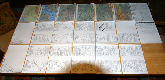
Due to the unreliability of anything computer-based, I always print out everything essential. For this trip, we had six legs to plan so ended up with six lots of printouts
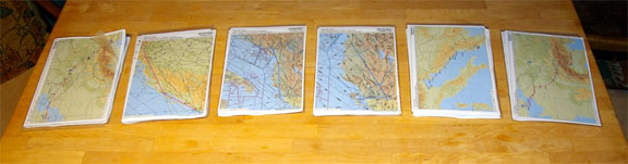
each of which contained the overall route picture, several enroute sections (the scale on these being chosen so that airways intersection names showed up - Jepp software is poor in getting "little details" like this right), the plog, and all SID/STAR and approach charts for the destination and the alternate, and a printout of the CFMU screen showing the accepted flight plan route:
Because IFR routes are relatively predictable, it really pays to work out all the likely routes (as shown above) before leaving home, by making sure each one is acceptable to Eurocontrol. The actual flight plans can be filed shortly before each flight using the internet (I use the excellent Homebriefing service which charges Euro 36/year flat rate) or even by fax or telephone.
Mobile Computing & Communications
This is pretty well essential when doing a long trip. This kind of flying - VFR or IFR - is a long way from that of an airline pilot who steps into the cockpit having just been handed a folder with all he needs to know. The private pilot needs to be able to plan flights, get weather, file flight plans, fax prior permission (PPR) notifications, etc. One can manage without but then one ends up hunting around for internet cafes and messing about at airports where nobody (that can speak English) knows where the pilot information service is - if indeed one exists.
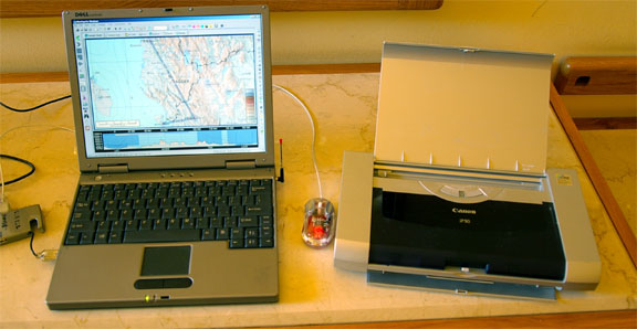
I use an old Dell L400 laptop with a Sierra 750 PCMCIA GSM/GPRS card which also does GSM fax, and the Canon IP90 inkjet printer. The printer is lightweight and prints in colour. There is a much smaller (and pricey) printer from Pentax but it is B&W only and uses special paper. It's a good setup except for the poor battery life on most laptops - in reality this isn't a problem because one can usually plug it in somewhere. The whole lot is not light but it easily fits into a backpack and gets left in the hotel room anyway.
Unfortunately one cannot rely on WIFI to the extent the popular media might suggest. Nowadays (2006) most city networks are secure and if you can find one you have to pay for it. Hunting around for internet cafes is a major distraction. I find that spending a few quid getting weather data via a GPRS connection is a whole lot easier. Some notes on mobile connectivity are here.
I also have been running a Motion LS800 tablet computer in the cockpit, mainly as a backup for the main IFR GPS. Unfortunately, as detailed further below, the hard drive fails at higher altitudes.
Shoreham to Ljubljana
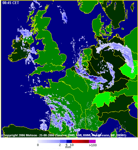
The weather planning was tricky. The atmosphere was thoroughly unstable over most of continental Europe, with thunderstorms (TS) all over the place. Luckily, the first possible day for our holiday, Friday 25/8/2006, provided a situation (MSLP chart 1200 and 1800, SigWx chart 1200 and 1800) which was worth examining more closely. There was a chance of thunderstorms along the entire route, so the question was whether one could climb high enough to be in VMC and thus avoid them visually. I looked at several forecast tephigrams (vertical profiles of the atmosphere) along the route whose temperature/DP spread suggested chart1 chart2 chart3 that there would not be any solid IMC enroute. I telephoned a professional forecaster too, and he agreed. I also got a radar image on the morning of the flight, from this fantastic Meteox weather radar site. The sferics (stormscope) data didn't show much activity until the very end of the route, and the weather there was forecast to be moving on anyway. (Note that the Meteox radar site does not display full coverage over the geographic area which it depicts; N Italy is not covered for example).
Looking at some of the cloudbases down below (TAFS) relative to the terrain, doing this flight under VFR would have required balls made of solid brass, not to mention the possibility of having to stop somewhere for a while. Bending the VFR rules and flying in cloud would not really be on due to widespread forecast CB activity. We did a similar leg under VFR in 2005, Shoreham to Trieste, and that was possible only because the clouds over Belgium and Germany were scattered and much lower down, and by the time the cloud tops started rising we were in airspace which was uncontrolled to FL195.
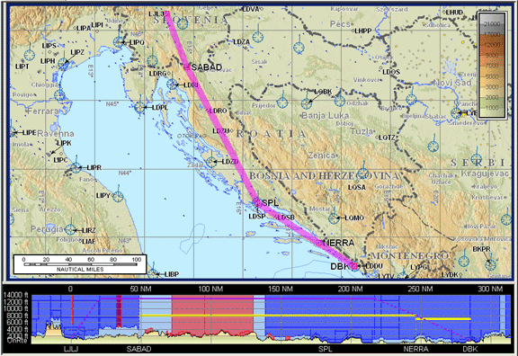
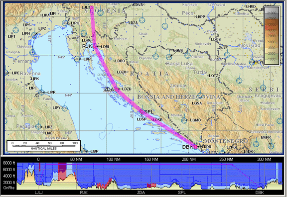
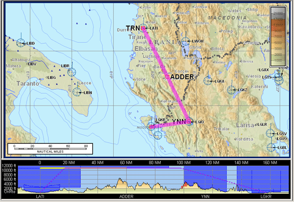
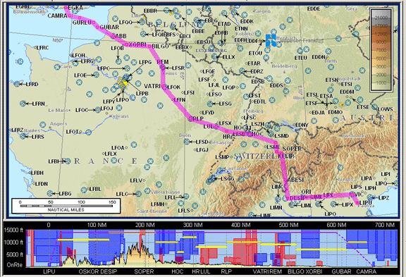
So off we went, IFR. The airways route, filed for FL150, was reasonably direct (alternate: Trieste LIPQ) with an actual distance of 689nm versus a great circle distance of 647nm:
EGKA MAY R8 DVR L9 KONAN L607 RUDUS L984 ASKIK Z74 DONIS L603 CHIEM P995 ARNOS P735 GILIN LJLJ
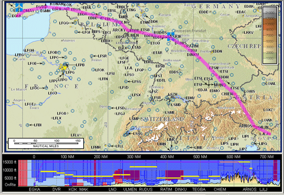
Warning: This article includes route illustrations (like the one above) produced by Jeppesen Flitestar/Flitemap, which include a vertical (terrain) profile at the bottom. It has recently (Feb 2007) come to light that the Jepp terrain elevation data is grossly inaccurate and can be several thousand feet out. Furthermore, the error is usually in the unsafe direction. This feature of the software is therefore useless for any flight planning or terrain avoidance purpose, even in an emergency.
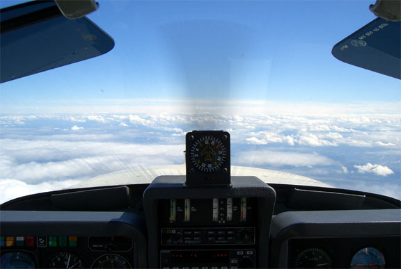
The weather turned out to be more or less as expected. Initially, UK weather was nice so we asked for a stop climb at FL100. This improves the TAS a little (the optimum for most non-turbocharged 250HP tourers is about 8,000-10,000ft) and conserves oxygen. This was good for about 100nm; then we had to go higher to remain VMC.
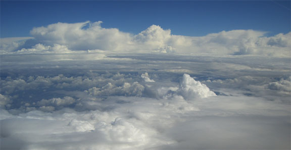
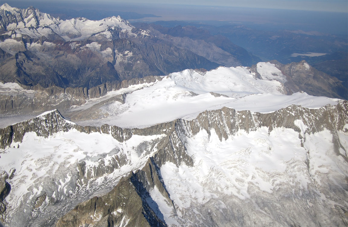
There was a lot of CU/TCU stuff up to about 20,000ft to the left of our route - exactly as expected from the radar image
In fact we had to deviate "due weather' up to 50nm to the right of the filed route. This actually helped to reduce the distance by bringing the route flown closer to the GC route. ATC were entirely co-operative (they have no choice really) and it was only at one point, approaching DINKU, that they were increasingly keen to get us back on track. I simply refused, explaining what was to our left; the following picture shows the tops at about 22,000ft:
The stormscope showed almost nothing enroute, which was undoubtedly correct - no TS so no discharges. We did enter IMC for a few minutes at a time, and in the OAT of -10C we did reliably collect a very thin coating of rime ice on the leading edges. This disappeared immediately when back in the sunshine. I have a TKS de-iced propeller and use it on the max setting anytime in freezing IMC.
We gradually climbed en route from FL100 to FL120, FL140, FL150, FL160. The TB20 was delivering a TAS of about 140kt at FL160
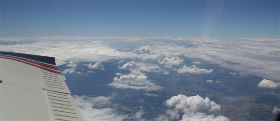
which with a 20kt tailwind resulted in good progress. Weather to the right of the route was excellent:
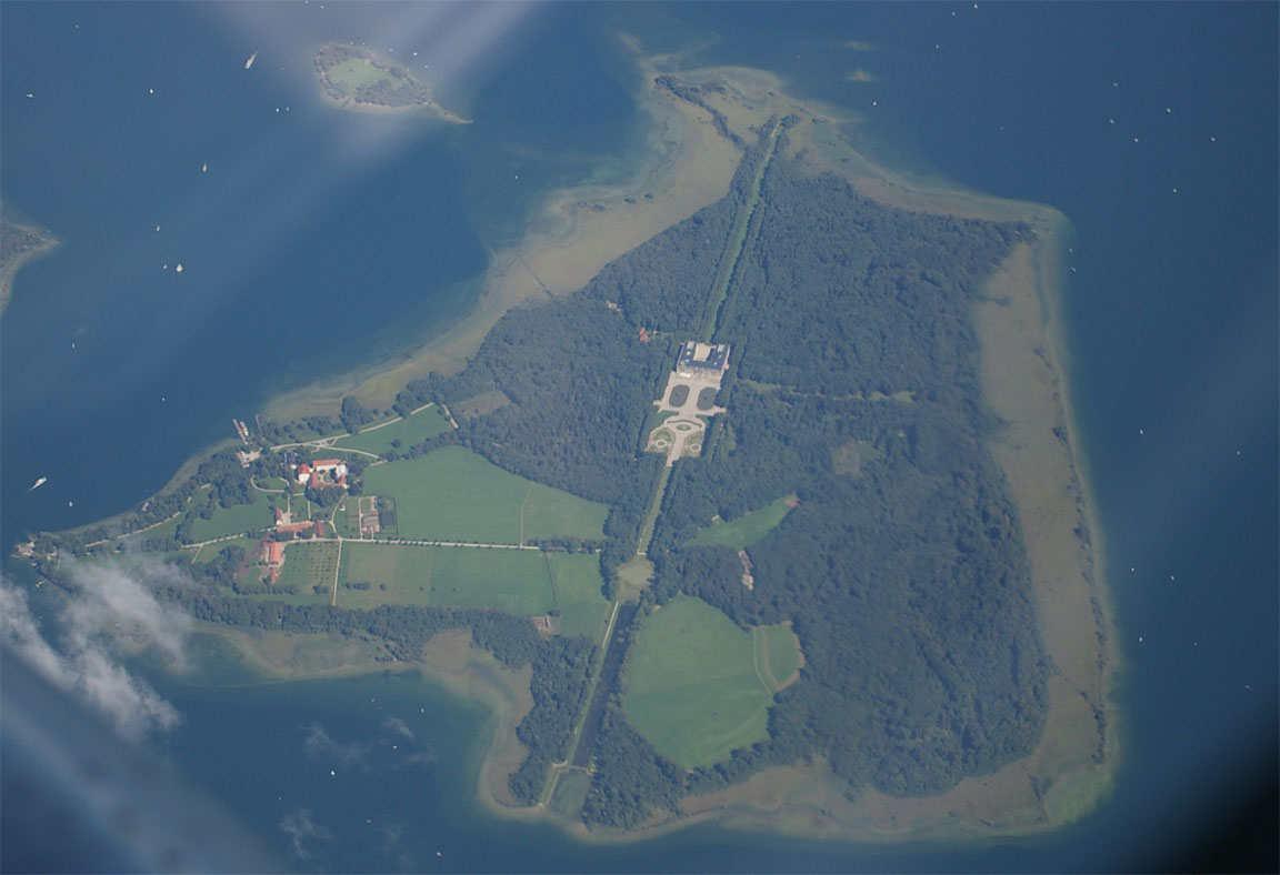
A lot of Germany was visible enroute, including this most impressive house on an island:
At about FL140, the LS800 tablet computer (running Flitedeck) died. It rebooted itself but would not load windows again. It worked OK back on the ground, reporting an invalid shutdown. Most likely, the hard drive stopped working at the altitude. This is something to be watched with anything that has a hard drive in it! The obvious solution is a flash drive replacement but I have not found one which would fit the LS800, and in any case they are very expensive.
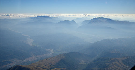
The Alps are not particularly high along this route
Unsuprisingly given the long time spent at FL150-160, we used up nearly the whole cylinder of oxygen on this flight, so it was as well that I had recently purchased a second cylinder which we carried in the back of the aircraft. This will be required for the return leg to the UK which is over the Alps again. Clearly oxygen duration is a major flight planning issue on long trips like this one. Some notes on oxygen equipment are here. We use an Aerox portable oxygen kit with a four-person regulator, the 13 cu. ft cylinder and cannulas. The system uses the standard Aerox cannulas as shown below:
I have recently purchased a Nelson Oxygen automatic demand regulator which should make the cylinder last a lot longer; unlike the older Mountain High electronic demand regulator this ingenious device does not use batteries but uses a different type of cannula which does not have the under-nose reservoir and has two separate tubes going all the way back to the demand regulator. This regulator costs about US$350 and you have to have one per person; I bought just one initially to see if it works and it worked perfectly at FL160, keeping my blood oxygen at about 92% (heart rate 76). More controlled experimentation is required to verify the supplier's claim of a 2x to 3x saving (over a constant flow cannula) but it certainly looks like it is working just fine.
Even though the approach plates do not mention radar, I was offered a radar vectored ILS. I periodically fly an ILS with the autopilot (a "coupled" approach) because this mode is obviously what would be used in any emergency or high workload situation, so the equipment must be tested regularly. However, when Ljubljana ATC gave me a base leg heading which was at 90 degrees to the localiser, the autopilot did not capture the localiser. Whether ATC realised this or not, they gave me another heading (the runway heading, more or less) at about the moment I was going to do something about it and disconnect the autopilot, and I completed the approach manually.
Upon departure from Ljubljana 2 days later I asked for an ILS approach so I could check out what happened, but it wasn't possible due to inbound traffic. However, the autopilot tracked the localiser fine into Dubrovnik, so I guess the KFC225 autopilot is unable to intercept a localiser at 90 degrees - not exactly suprising.
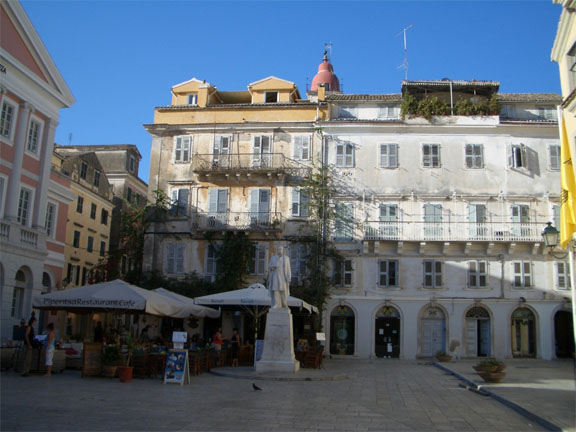
Ljubjana
Ljubljana is an absolutely lovely city. It's compact and easy to walk around. It contains a mixture of both old and modern architecture, and a mixture of the Mediterranean and the northern European.
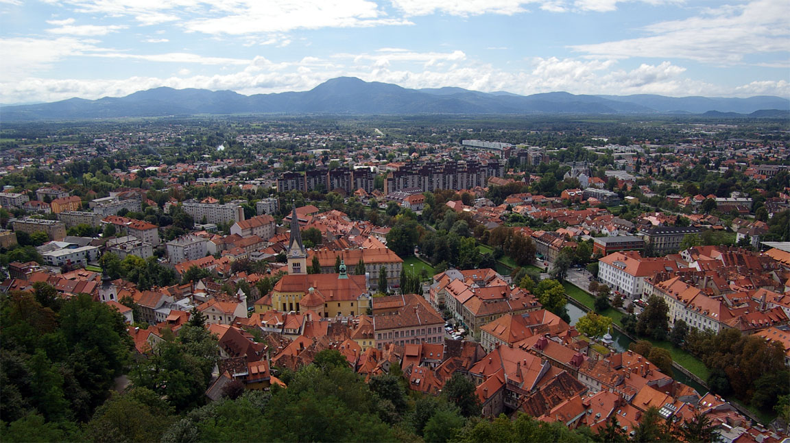
Everything is clean and well organised. There are regular buses from the airport into the town. The airport has an excellent GA office where on departure they hand you a briefing pack with the weather, relevant notams, and drive you in a minibus to the aircraft. It takes less than 10 minutes to sort everything out. The Avgas bowser accepts credit cards and the Air BP card. We paid about Euro 50 for landing and 2 nights' parking which is excellent value. There was some sort of PPL training going on, using modern composite aircraft, during quiet periods which appears to be much of the day on weekdays.
There were few "obvious" tourists, and there was a huge number of young people around who obviously live there. The population is a far cry from that seen in a typical UK city; it is healthy, fit, happy, and shows none of the aggressive fashions and behaviours so commonly seen in the UK. Yet the country is strongly pro-Western and clearly feels closer to northern Europe than to anywhere else. I know from other connections that their education system is excellent and the country is technologically advanced. This is a country with huge potential in Europe but we wondered with some sadness that perhaps we are seeing it at its best and it's going only downhill from here. Britain is a fine example of how bad things can get, with a decrepit State education system, gross obesity starting with very small children, and a strong anti-intellectual bias culminating in "freak shows" on TV like Big Brother. MacDonalds have opened up shops in Ljubljana so it's only a matter of years before the population catches up.... of course I hope I am wrong and that they work to preserve what they have.
All food in Ljubljana was really excellent. The prices were slightly below Western European prices.
Ljubljana to Dubrovnik
Like all flights on this holiday, this flight was pre-planned IFR back home with this route (alternate: Corfu LGKR):
LJLJ SABAD L862 SPL L607 DBK LDDU
However, CBs were forecast in the vicinity of Dubrovnik and this was a regular feature for a number of days. It was thus apparent that while there would be no problem flying it at whatever it took to get into VMC, say FL140, we could get snookered into ending up at FL140 near the destination and having to descend through a great deal of very turbulent muck. The tephigram for LDDU suggested there would not be solid IMC in the area but on balance I decided to take the much more visually attractive low level VFR route. With hindsight this was not the best decision since the high level route would have worked out fine - with detours around weather as usual.
The VFR route was the obvious picturesque one along the former Yugoslavian coast, filed for 5000ft:
LJLJ RJK ZDA SPL DBK LDDU
The days when one could fly around Europe without one's passport even being looked at (while airline passengers endured various levels of hassle) may be coming to an end. On the way out through Ljubljana airport we were thoroughly searched, with us having to take off our watches, everything else metallic, and unpack a heavy backpack full of equipment, with a queue of airline passengers behind us. I protested that this is a "private aircraft" (i.e. we are hardly going to blow ourselves up) but the security man said that we are getting access to airside where other aircraft are parked.
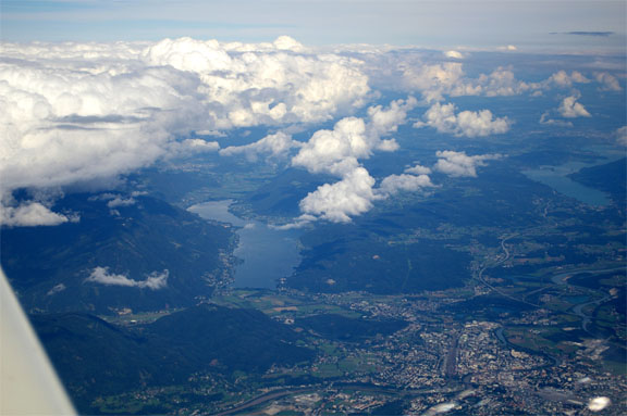
Going VFR proved to be of marginal benefit as we were unable to - due to terrain and cloudbase being rather too close - head straight for the coast and soon had to climb, in stages, to FL110 to get on top of a lot of cloud which despite being scattered extended vertically almost all the way down to the mountainous terrain of Slovenia and Croatia. The stormscope was showing heavy returns all above the mountains, and this was exactly where the CB activity was visually evident, with the lightning probably being at a very high level. My error here was not having got TAFs and METARs for airports along the route - something one should always do when going VFR!! Probably, the reason I didn't do it was because the flight was expected to be at low level along the coast and thus below any likely weather. In fact the WX500 stormscope amazes me how accurate it is in azimuth - though not in range which can be out by 2x or more.
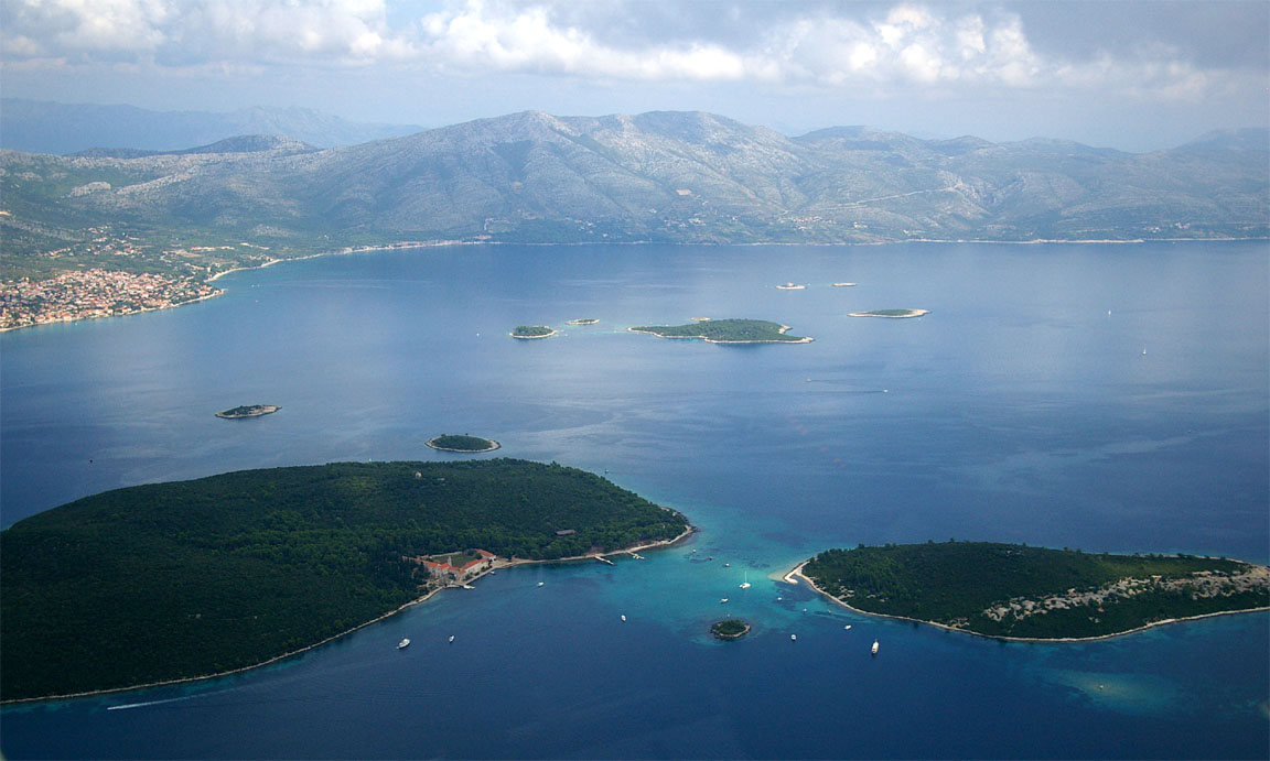
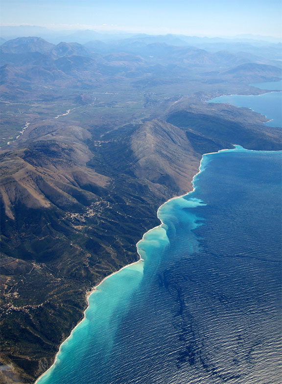
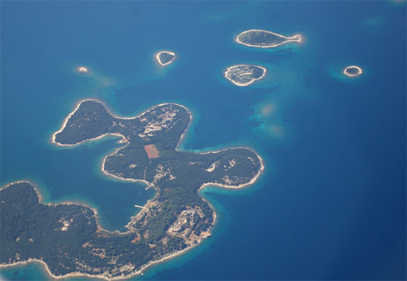
The weather cleared up about halfway down and we headed for the coast. The flight continued at low level along the beautiful scenery comprising of the Croatian coast and many islands of various sizes
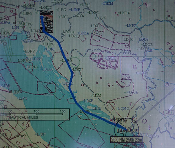
Slovenia and Croatia ATC were totally helpful, with a radar service all the way. The route actually flown is shown in this rather poor screen photo from Flitedeck running on a tablet PC:
I asked Dubrovnik Approach for an ILS which they were happy to offer. However, this was when things started to get interesting. We were down to 2000ft, just below the scattered cloudbase and in perfect sunny VMC. The stormscope was showing heavy returns all over the place which were clearly above us. As I was established on the localiser, an Airbus A320 which landed minutes before us reported a CB with lightning over the airport, 37kt of wind shear (not sure how he worked out it was precisely 37kt) and then we saw the runway shortening in front of us as rain heavy enough to be totally opaque worked its way along the runway, from the far end towards us. Concurrently, several bolts of lightning struck from the cloudbase into the sea, no more than a few hundred yards to the right of the approach path. The picture below shows (yellow dots) where the lightning was going:
At this point we were still a few miles out, in perfect calm sunshine and I was rather enjoying the amazing picture and thinking about what to do about it, but Justine started to get very concerned so I decided to do a 180 back and advised ATC I would go back to the NDB located about 10nm further back; their response was "smart choice". We spent about 20 minutes flying backwards and forwards at 1000ft among the islands until the CB moved on. During this time, some airliners landed, amazingly... Our landing was uneventful, in very light rain and nearly calm wind.
So this is what PROB40 TEMPO 0915 TSRA FEW020 FEW030CB can look like, on the rare occassions when it does materialise at the worst possible place.
Massive CBs and showers like I have never seen before are clearly a feature of this place. On the evening of the landing another storm arrived, thoroughly flooding the town. In fact the weather was like this for the entire holiday to this point; every TAF had a PROB30 TEMPO of TS and CB or something similar. One can see why weather radar is so useful.
In retrospect this flight would have been better done under IFR, at high level, and then descending near the destination for a visual approach. The view along the route would have been nil though.
There were just a few GA aircraft parked at Dubrovnik, and appeared to have been sitting there for a very long time. However they did have several business jets moving about.
The airport at Dubrovnik is nothing like Ljubljana. It is very busy with tourists and disorganised, with buses running only a few times each day when there is a commercial flight arriving or departing, and to no apparent timetable even then. The avgas bowser man accepted only Mastercard or Amex; a strange combination. There is no support for GA; not that I needed any since I have long been completely independent but it took me a while just to find somebody who knew where to go to pay the landing fee. The airside bus came back several times while we were sorting out what to take back with us; this appears to be the one thing which one can rely on at every airport.
We headed for the famous "old town" of Dubrovnik
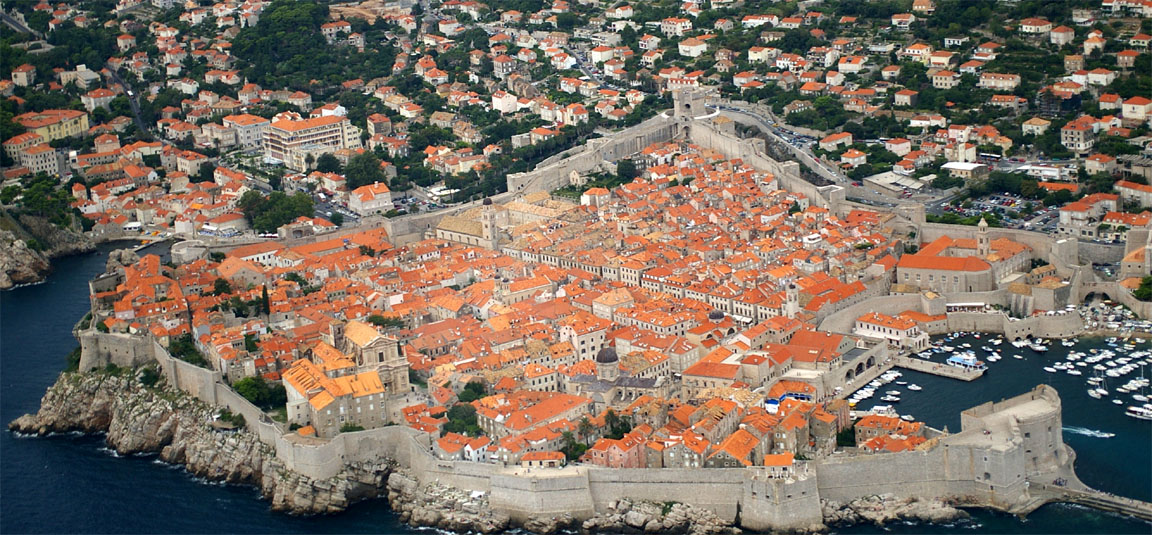
The 10-mile bus ride into the old town is stunning, both for the views as it weaves around the mountain roads and for the kamikaze drivers who were overtaking the bus on blind bends.
The old town is a great piece of history. It is very old but most of it was rebuilt 400 years ago following an earthquake. It was also thoroughly shelled in the 1991 conflict, taking a huge number of hits most of which appear to have been very well repaired.
In complete contrast to Ljubljana, while some people do live in the town, it is packed solidly with tourists. This does not detract from the beauty of the place which is probably best appreciated early in the morning before the crowds come out and when the light is better. We were lucky though in having a place to stay which was yards from the main street.
There is only one hotel inside the old town which was predictably sold out, but they referred us to a very nice apartment just around the corner for Euro 140 per night. This turned out to be an excellent location and much better than most of the hotels which need a bus or a car to get into the town. All the food was really excellent; prices were on par with most places in Europe.
The landing+parking charge (3 nights) was about Euro 50 which is very reasonable.
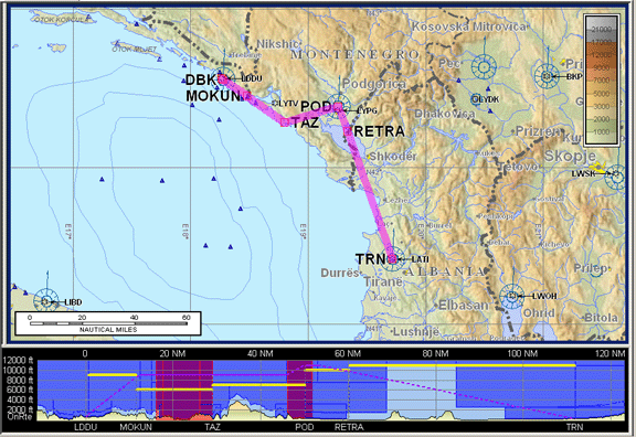
Dubrovnik to Tirana
The filed route (OK with CFMU at anything above FL110) was (alternate: Corfu LGKR):
LDDU DBK R45 TAZ POD L604 TRN LATI
The weather picture was mixed (SigWx, TAFs/METARs) with a probability of TS and CB. On the morning of the flight there was no TAF available for Tirana but others in the area were pretty similar. The Tirana METAR showed a nil (24/24) temperature spread but high cloudbases; this would be pretty weird if seen in the UK... anyway we had plenty of fuel and the alternate looked good.
I had faxed Tirana ATC some weeks before the trip asking them for any specific information. They were very helpful and replied by email with details of their "CAA" address and contact to which to send a bunch of aircraft documents; permission is required to land in Albania. I faxed these over but they didn't come out too well at the other end so I referred them to a website URL from which they could download them. Unfortunately the permission had not arrived by the time of our departure from the UK but I got a phone call from the contact to simply phone him the day before we are going to go there and he will arrange it. An email arrived the day before this flight with a permission number, so that was that problem solved. They also faxed it to my UK office number. The permission number was entered in the flight plan remark field.
Dubrovnik was operating a SID (rather than a radar departure) which takes one way out over the sea and then back again, climbing the whole way to a minimum 9000ft. Our clearance specified FL100 by TIBRI; we were about 300ft short and the controller (who was obviously watching us on radar) requested a 360 turn to get the extra height. This was curious as there was no obstacle clearance issue at that level. We climbed initially to FL100, gradually going up in 1000ft increments to FL140 to stay above clouds. We were given a direct TAZ-RETRA but had to fly slightly right of the route due to weather anyway. ATC were totally helpful, with me requesting weather avoidance every minute or two. The Tirana VOR was unserviceable (this was notamed so known in advance) so they were operating the NDB18 procedure; also it meant that their STARs were inoperative because they join onto the VOR approaches only. As a result of all this, perhaps 1/3 of the total distance flown on this flight was spent on the two instrument procedures!
The flight was bumpy in a few places early on, where a cloud had to be transited and could not be reasonably avoided. The rest of it was fine. At one point, at FL140 and above a smooth overcast layer with no turbulence at all, we encountered an updraught which - with the autopilot holding a constant altitude - pushed the IAS from about 120kt to 160kt. It's hard to say what the vertical speed of the airflow was but probably over 500fpm. I did check out (on a later flight) what VS value would have the same effect at FL140 and it is about 500fpm. The most likely cause was wind from the sea going up the mountains which were inland (east) of our route. If this had been a downdraught then we would have had to turn right (west) to get out over the sea, just to hold altitude. It lasted only a minute or two.
Several airliners were inbound also and one had to hold while we flew the long NDB approach. One of them descended to 6500ft instead of 8500ft; he got a polite warning by ATC but he would have got a mountain instead if he did it a bit further to the west, and in IMC
Once we were past RETRA, Tirana ATC gave us stepped descents to 6500ft over the NDB; then we did a procedure turn back out to fly the approach plate, descending 6500ft to 3300ft once established on the outbound leg.
The KLN94 GPS database contains these procedures as overlays and I always use these in conjunction with the real navaid, but some of these overlays leave a lot to be desired; the LDDU SID being one a fine example of a half-complete and misleading representation.
The final part of the approach was well visual but there was about 20kt of crosswind
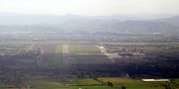
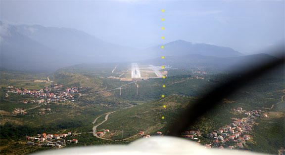
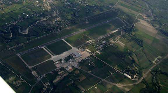
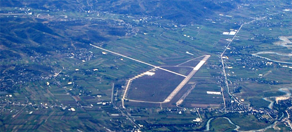
The airport - Tirana's only accessible one - is big; no doubt built for communist-era military transports
We were taken on the usual bus to the terminal, and had no problems getting out. We had to pay Euro 10 each for an entry visa and there is a similar payment to get out again. The landing+parking charge is made up of a list of items which can include airport lighting if landing at night, and at Euro 223 it was not at all cheap...
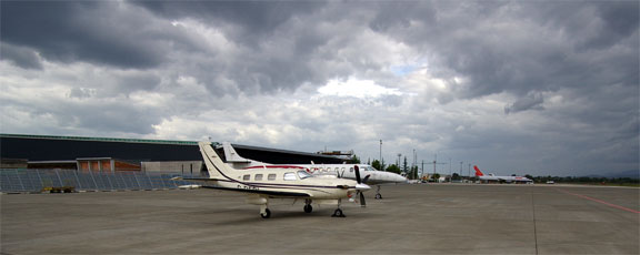
Unsuprisingly given the landing charges, there was only one GA aircraft parked on the vast apron; a G-reg Piper turboprop
This flight could have been done under VFR, along the coast over the water, so long as the cloudbase over the piece of Albania from the coast to the airport was at least 2000ft; there is some terrain at 1000ft. I don't know if there are mandatory VFR routes in Albania though, or indeed their attitude to VFR. A bigger problem is a lack of VFR charts for the area; Jeppesen don't cover it and the only option is the U.S. ONC/TPC chart whose most recent edition is 1998 and which shows no controlled airspace and is thus useless for anything other than basic terrain. Presumably the Albanian AIP contains enough information to plot the CAS outlines, and flight planning software that gets updates from national AIPs (Navbox and Jepp Flitestar / Jeppview) should also contain it. But flying IFR does away with all that stuff.
Tirana city is about 15 miles from the airport; no doubt this distance was intentional given the well-known tendency of aircraft operated by the former Eastern Block countries to fail to remain airborne...
We had just two nights in Tirana so we did not see much and in any case one could never do justice to this beautiful country in a few paragraphs.
The city's large museum
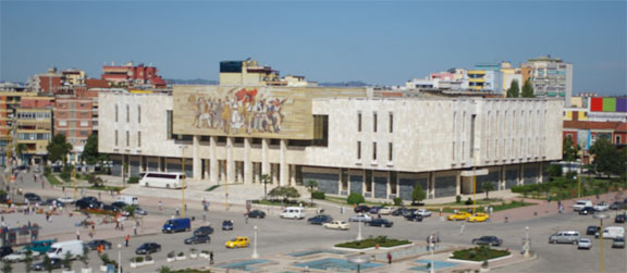
has a truly spectacular mosaic on the outside (300k jpeg) depicting the various Albanian revolutionary phases. The museum covers the Albanian history from centuries ago, through countless troubles, right up to present day and is absolutely fascinating, despite most of the exhibits being described only in Albanian.
Albania appears to have been in a nearly constant state of subversion, revolution, counter-revolution, tyranny, isolation, poverty and a few other things, usually several at the same time, throughout most of the 20th Century and until just a few years ago. It's been run by the worst possible people who consistently made the worst possible choices when it came to foreign alliances. The content of the museum and the art gallery is something which myself, having lived in communist Czechoslovakia from 1957 to 1969, could recognise but it was still pretty specialised stuff which only those well informed on communist doctrine and propaganda generally and regional politics specifically could appreciate fully.
Thankfully this era now appears to be behind them, but they have a huge amount of reconstruction to do which is difficult because of lack of money, and management expertise and - many say - poor political leadership and widespread corruption. There is a number of Western companies operating there, however. Most of the young people are doing their very best to look Western and, in the absence of Western excesses in food consumption, they do look pretty good and are not dissimilar to the people of Ljubljana. I hope they succeed.
We stayed in one of the "top" hotels, the Chateau Linza, which was about Euro 150 per night for a double room; it looks like a typical communist-era building from the 1960s but actually it was built in 1994. It lies on the side of a hill with a regular minibus running into the city. A UK Health & Safety inspector would have a fit if he saw this or this, or even this, but thankfully they have not yet acquired the West's anally retentive safety culture and - apart from the number of drunken communist party functionaries who must have fallen onto that staircase - I admire their resourcefulness. The minibus doubles up as transport for hotel maintenance. The hotel would have been very quiet at night - no traffic in proximity - but there was a constant barking of dogs outside. Prices in the hotel restaurant were fully to Western levels; at least double what most places in the city would have charged.
The hotel had great views of the city
The hotel food was not great but fruit and vegetables were excellent; apparently they are all organic because the farmers are too poor to use fertilisers or pesticides. The food in the city itself was excellent and there is a huge number of bars, cafes and restaurants. There is a strong Italian influence.
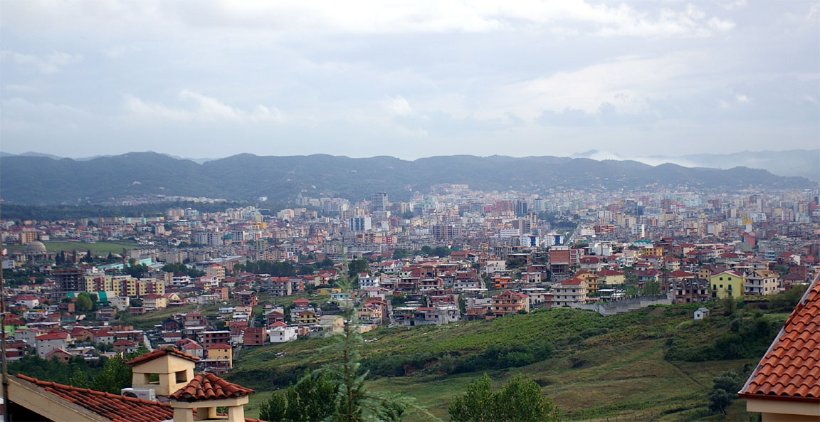
There is obviously a lot of money around in small pockets. This is evident from the many very expensive vehicles and many upmarket shops. It just doesn't work its way down through the economy very well. Most of the city is run-down, packed with a lot of poor people and decrepit traffic working its way around the potholes. Many of the vehicles are old Mercs which are run nearly into the ground - Tirana would be a great advertisement for the durability of Mercedes cars!
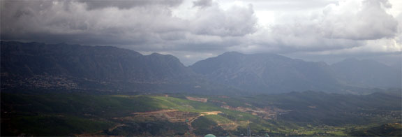
Tirana has spectacular sunsets over the mountains

We used a Brandt travel guide for Albania, which was well out of date on several counts. The funniest one was this supposedly nice hotel which we found to be shut and then we found an article in an English-language newspaper reporting that the hotel had been used as a brothel, at Lek 1000 (about Euro 10) per "transaction". Whether this is good value cannot be judged without additional information...
There are a number of nature reserves and I think one week is the minimum time needed to have anything like a good look around these. We will be back.
There are very few other airports. We saw this one
on the way to Corfu which was almost certainly Berat but it is military only. This airport is not shown on the Jeppesen IFR charts (nobody publishes current VFR charts for Albania, Greece and much of that region) but is shown on the 1998 U.S. ONC chart. Like Tirana, the runway is big enough for the space shuttle, or an overloaded Tupolev departing downwind on one engine. The above picture was taken at FL120.
Mobile internet access was something else. My Orange phone did not work at all; clearly Orange have not bothered to set up a roaming deal with anybody here. Vodafone worked fine but there was no GPRS access at all. There are plenty of internet cafes in the city and we had internet access in the hotel (about Euro 2.50 per hour). Strangely it was not possible - as in Dubrovnik - to run a VPN (a secure network connection) even if an ethernet cable connection was used rather than wifi. I wonder if the VPN ports are blocked in these countries. I can run a VPN over Vodafone GPRS from anywhere but only if GPRS works in the first place...
The only ways to get truly mobile internet in Albania would be with a mobile phone used as a plain 9600 baud GSM modem (dialling one's UK ISP and pretty slow and expensive; also it is possible this service is blocked here too) or with a very expensive satellite phone.
Fax worked fine, on Vodafone GSM, which is pretty amazing for a PAYG service. With a suitable modern receiving fax, an A4 page would send in a few seconds. Vodafone is one of UK's more pricey networks but one can see why serious corporate (contract) users go for it: except for GPRS in Albania, it works when you need it.
Just don't rely on the frequently defunct Vodafone website for topping up your PAYG card account - my balance ran out and there was no way to top it up. Luckily I had some other SIM cards with me. The entire UK "mobile data" business is based around contract (not PAYG) customers and nobody cares for sporadic data users. However, the generous GPRS/3G data allowances which come with contracts tend to disappear when one is roaming, which is nearly all the time when abroad... Obviously the networks have exactly zero incentive to end this lucrative little earner. The nearest partial solution is to get a GPRS/3G contract phone and use it as a bluetooth-connected data modem; then at least you combine voice and data usage under the one contract.
The hotel had an "internet PC" but it was a knackered old machine on which the mouse barely worked. These days, with this kind of equipment costing little and a new mouse costing less than an Albanian beer, this is not acceptable in a hotel charging Western-level prices. But it was better than nothing.
The night before departure I checked the weather on the hotel's internet PC and filed the flight plan via Homebriefing as usual. The VOR was still not working and looking through the SIDs for Tirana, none of them referenced the NDB. Sure enough, on the day they were doing a sort of radar departure.
Tirana to Corfu
The filed route was (alternate: LDDU):
LATI TRN L604 ADDER YNN LGKR
Before departing on this trip I had some email exchanges with Tirana ATC who informed me that the minimum DCT leg length in Albania is zero which means that airway routes must be strictly followed to get CFMU to accept the flight plan. However, he added that a direct route is usually given on the day. Anyway, I would have been suprised to be routed via YNN as shown above.
There is no avgas at Tirana but we had filled up at Dubrovnik. Corfu has avgas so fuel was not an issue. Lack of avgas at Tirana was notamed and known but reading the Jeppview text pages (which state avgas is available) it isn't clear whether this is permanent or not.
Getting out through the airport was initially difficult since it has no evident general aviation facilities. The first trick is to discover that one does not need to queue behind the normal travellers for passport control; an official will escort you past the queue. Security was tight. Our baggage was thoroughly searched and everything including watches etc x-rayed; various items (e.g. small tools) were commented on as being banned but the official conceded there isn't any point since this is a private aircraft. The next problem was finding the office where the landing+parking fees would be paid; nobody knew where this might be. We started by having a difficult conversation with a security guard through a glass door which she would not open but soon found the right person who was extremely helpful, escorting us through the various routes to the correct office and everything was smooth from then on. The office was unable to accept credit cards (apparently they can but it means walking to another building) so I gave them my entire bundle of US dollars which I had brought with me "in case", plus my remaining 4000 Leks. I think that the next time we go there, we will sort out the payment details by email or fax, in advance. There is a Euro 10 charge per passenger, which is anybody without a pilot's license.
Everybody was very helpful and very kind - mirroring my experience with the Albanian Aviation Ministry whose official phoned me at home (in the UK) on my mobile number with last-minute information on how to get the landing permission. They were pretty amazed to see the aircraft; there was a large business jet parked but I don't think they had a light aircraft visit before. The driver of the bus (who taught himself English and does various other duties) asked if it can do aerobatics; I explained it does not have an inverted oil or fuel system. He and the follow-me van driver were chatting to us, very curiously, for quite a while. I have not seen this sort of polite and helpful attitude anywhere else and it is great to know for when we come back next time.
However, the airport does need to reduce its charges by at least four times (for this class/weight of aircraft) because at this rate nobody below a business jet is going to go there. They should also have a signposted "General Aviation" office. To be fair even Kerkira does not have that, and there are a lot more forms to fill in in Greece, but people visiting Greece accept all the pointless formalities as the price of doing anything in Greece. There is no reason for Albania to adopt the same pointless job-creation schemes. They can start with a clean sheet. Their AIP mentions the airspace is Class G up to 10,000ft, in areas where it is uncontrolled, which opens up good potential for VFR flying. An article in a Tirana newspaper reported that the Government has banned the ownership of fast powerboats - presumably to keep a lid on smuggling of goods and people - so perhaps GA activity is not welcome after all but aviation access should not be a problem because the security of all the large airports is high.
Due to the unserviceable VOR, Tirana was operating some sort of radar departure. There was some ambiguity concerning the departure instructions; probably the fault of both myself and the tower controller. Initially I was offered runway 18 or 36 at my discretion. With the wind 360/10 I obviously chose 36. I read back everything as I understood it but I don't think the controller could understand my readback. This sort of thing is pretty normal in the more southern parts of Europe but it can be confusing, or worse. I got what I thought was a taxi instruction to the runway 36 holding point (confirmed by the FOLLOW ME vehicle driver gesturing to me) so off we went there. Then, when I asked for a departure clearance, it turned out that the controller thought he never cleared me to taxi anywhere; he also would have preferred me to taxi to runway 18. An airliner was departing on 18, presumably happy with the tailwind because the runway is long and if going south it saved them a turn after departure but I would have found the turn handy to achieve the terrain clearance in the climb, for the 7000ft mountains which cover the horizon to the south and east
Some of the departing aircraft were also using wrong terminology, notably the words "request takeoff". However, ATC were completely helpful and very courteous at all times. It's possible they wanted me to depart from 18 because it provides better wake turbulence separation behind an airliner which has just departed on 18. However, taxiing to the 18 holding point from the 36 holding point is a very long way at Tirana!
The relevant SID (DIMIS1A or DIMIS1B) is odd because it does not specify a minimum climb rate to a level high enough to clear the terrain; clearly ATC use a radar departure (even if a SID is overtly flown) to make sure everybody is high enough before they get too far. My understanding is that a SID should guarantee obstacle clearance for the whole route which it depicts but perhaps this is incorrect after all since L604 has a 11,000ft MEA all the way from TRN and since nothing short of an F16 can reach 11,000ft at TRN following a LATI departure, so there must be another process used to achieve obstacle clearance.
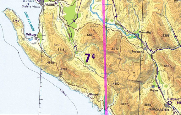
At one point they asked me my rate of climb. The initial clearance was FL120 (as filed) but looking at one mountain looming ahead this didn't look enough and also with a 40kt tailwind I expected some turbulence from air flowing over the terrain so I asked for FL130. Looking at the only available "VFR" terrain chart for Albania, a 1998 U.S. ONC G3 chart, there is nothing shown above about 7000ft but the mountain (on track between TRN and PITAS) really did look like 10,000ft. Either this was an illusion (of a kind I have not seen before) or there is a massive error on the ONC chart. The following chart section shows something close to the route actually flown:
It was as well this was a perfect weather day....
This time, the LS800 tablet computer worked OK at FL130, so it looks like the altitude shutdown problem appears somewhere just above that.
We soon got a DCT PITAS and then a DCT Kerkira while still talking to Tirana. The island of Corfu was visible from about 50nm away and soon we were above the last of the Albanian mountains - here we were still at FL120
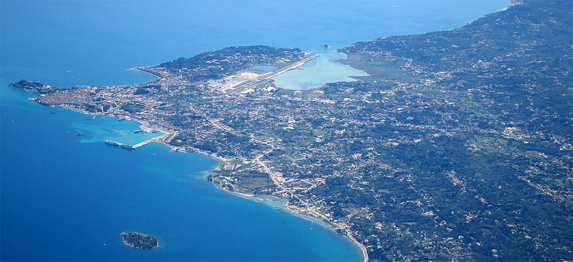
The following picture shows the Corfu town and the runway, from about 11,000ft
Kerkira ATC then gave me vectors and descents onto the VOR/DME approach for runway 35 - exactly what was expected based on what I saw on previous visits there. A number of 737s packed with holidaymakers were queuing for departure so I took great care to do a perfect landing; easy given the calm wind and the huge runway. One of them called another "Good afternoon Nigel"; suprising as I thought "Nigels" were British Airways only.
We got avgas after landing and before the bus (which arrived immediately, as they always do) got a chance to take us away from the aircraft. This is most important; once the airport crew get you off airside they have little incentive to find the fuel truck and you can wait for hours....
This flight could have been done VFR but, as with the flight to Tirana, I don't know the VFR procedures for Albania. Corfu is certainly OK with VFR; I have done it several times from further back (Switzerland or Italy). The only VFR chart is the U.S. ONC G3 sectional whose last edition is 1998. My previous VFR flights to Greece involved hand-plotting controlled airspace and danger areas onto the G3 chart, using Navbox and the Jepp Low Level IFR chart #13/14 as the reference. This ridiculous process yields something like this (a 1MB file showing a section of the marked-up chart). Flying IFR does away with all that...
We did not know how long exactly we would be staying for so we didn't pay the airport charges at this stage. They eventually came to about Euro 90 which is reasonable (landing and 5 nights' parking).
One always parks in the far corner of the large GA apron, next to the decrepit old terminal. There was just one other GA aircraft parked there; an old PA28
Getting out through the airport was easy enough. Initially it appeared that nobody knew what to do with a GA arrival from Albania! We went through passport and Customs controls without difficulty. We booked a hotel for 1 night through a booking agent in the airport (Lord Travel), got a taxi into the town and once we checked that the hotel was OK we extended the booking for 4 more nights. This is usually much cheaper than just walking into some hotel and asking for their rates.
Corfu, or Kerkira as it is also called, is a beautiful city, combining Italian, Greek and old European cultures with very pleasant weather - not too hot or dry. It has many leafy parks and walks and nice beaches. The large volume of package tourists get shipped off to resorts around the island but the town is pretty full during the day and evening. Even so, by the time we were there (1st September on) many had clearly left, with periods when a 737 departed every few minutes. There is a huge number of cafes and restaurants, with those in the city centre charging fully western prices
I am not sure the seawater is clean; I caught something nasty on the 2nd day after a swim. There is an intermittent smell of sewage, not only around the beach but also around the town. It's not unusual to smell something when sitting at an outdoors cafe.
With both Customs and avgas, Corfu serves as a common general aviation entry point into Greece. I have heard from local pilots that although Greece is in Schengen it disregards its treaty obligation for aircraft and thus forces all entry and exit from the country to be via Customs airports - of which there are few and even fewer that have avgas also.
Corfu had GPRS; just as well since there are said to be just three internet cafes in the entire island and we found only one. Greeks, like most continental Europeans, are heavy smokers and internet cafes tend to be well smoked-out; not my favourite place to spend an hour but far far cheaper than the ripoff GPRS pricing which reaches about Euro 30.00 per megabyte.
The town of Corfu does have a lot of tourists but it is clear that - at the time of our stay - most of the people milling around were locals. Many are teenagers who go out in the evenings in large numbers to meet up with their friends; it's very nice to see. There was not the slightest sign of any trouble. The place is very busy and the traffic is as bad as anything seen in any Western city. Most of the food is very good.
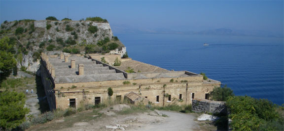
We visited the old fort
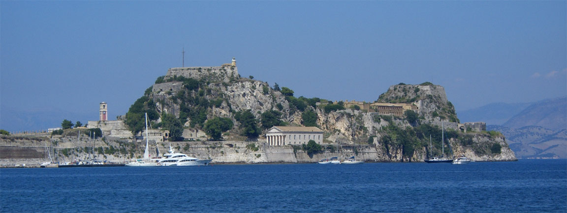
which is joined to the island by a bridge. It was a fascinating piece of history, full of corridors, staircases, dungeons, escape routes, mysterious dead ends... A lot of the buildings within were bombed out during WW2 and have been rebuilt but the whole lot - apart from a small museum, a cafe and a tourist shop - appears to have been abandoned and vandalised around 10 years ago and now the whole lot is slowly falling apart. One grand old building which was some kind of library
is full of smashed computer equipment dating from early 1980s to about 1995.
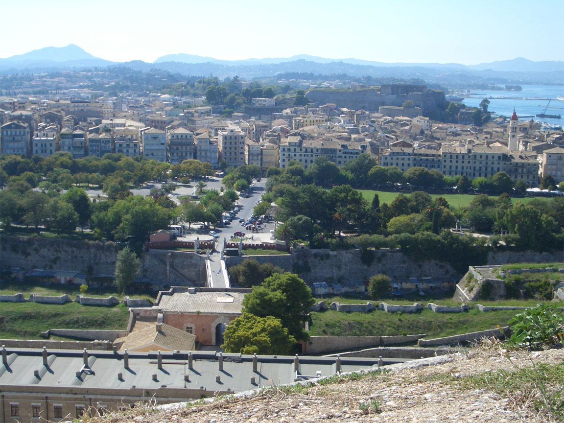
One can walk up to the very top of the fort, to the vandalised lighthouse, to get great views of the town
At this point (Monday) it became apparent that a large cold front over the Alps was likely to affect the planned return to the UK. Justine needed to attend a conference back in the UK the following Monday and could not take the risk of not getting back; she is also not happy about flying in any turbulence. So we agreed that she should book a cheap 737 flight from our next stop - Venice - to the UK, on Easyjet. This is a common scenario on longer trips with passengers, which is why I would never do a long trip with a passenger unless they accept this possibility. It isn't a problem in reality because most such return flights are pretty cheap; especially on weekdays. It greatly reduces the pressure on the pilot who is now able to take a more technical view of the weather conditions.
Corfu has an astonishingly rich history which includes having been invaded, or attempted to be, by practically everybody who has ever managed to work out how to sail a boat. We visited Mon Repos (a large residence where Prince Philip was born in 1921) and several archeological sites
Of the Greek islands we have been to, Corfu is perhaps the one which one could usefully live at, on a permanent or semi-permanent basis. It has great weather most of the year, is compact and easily accesible on low cost airlines, and everything is reasonably handy. I am not sure what it would be like to operate a light aircraft from there; the 48-hour PPR mentioned in the notam (which is clearly totally pointless) prevents going anywhere at a short notice. We did see some traffic doing what looked like loose circuits so perhaps one can come to an "understanding" with the airport.
I have written about Corfu on the previous trips to Crete and Santorini.
Corfu to Padova (Venice)
The filed route was (alternate LIPQ), FL120:
LGKR KRK M600 YNN L611 RODON R45 MOKUN DBK L607 ZDA N606 PUL P11 ROTAR M167 CHI LIPU
Originally we were going to go to the main Venice airport, Tessera, but when I faxed them for any pertinent information they returned a very brief and rather arrogant rubber-stamp fax saying they are closed to GA... In reality it is unlikely this is the authorised position since one could just file an IFR flight plan and depart and they can't then refuse a landing, but it's best to not push one's luck in Italy where nothing happens the same way twice. It's possible this was due to the Venice Film Festival and their parking was full of film-star business jets. As on the previous occassion in 2004, the other Venice airport, San Nicolo, returned different information about Customs and avgas depending on which day of the week one contacted them, so I gave up on that one as well. We could have gone to Trieste (as we did in 2005) which is a really nice airport and city and has Customs and avgas and is relatively close to Venice, but we decided to go somewhere different.
Nothing is ever simple. For Padova, Navbox states that Avgas and Customs are available. The Jeppview Text Pages (which cost a great deal of money) state
Padova
44' LIPU +01:00* N45 23.8 E011 50.9
Apt Operator Operator (049) 8716355; Fax Operator (049)
8715681. Apt Administration (041) 5415160, 2606706; Fax (041)
2605711, 2605709. ARO (049) 8727111; Fax (049) 8727108.
04/22 3681' ASPHALT. SIWL 33. LDA 04 3478'. LDA 22 2946'. TODA
04 3812'. TODA 22 3845'. RL.
Rwy 22 Right-Hand Circuit.
OCT-MAR 0800-1900LT. APR-SEP 0800-2000LT. Customs O/R.
F-3. Jet A-1. ABN O/R. Fire 3.
i.e. no Avgas. So I sent them a fax. A very helpful man phoned me back almost immediately on my mobile, explaining that Customs are not required in this case but the Police (whatever that means) is required and they have it. No prior notice is required, apart from the normal flight plan. Plus they do have Avgas. About a year later I discovered that F-3 (which does appear above) is the Jeppesen abbreviation for Avgas!! Jeppesen use F-3 and 100LL interchangeably.
To get the above airways route through CFMU at a single level, it has to be FL120 or higher. The plan is to ask for ATC clearance to fly lower, say FL100 or less, to conserve our oxygen; with just one whole cylinder left there isn't enough oxygen for this flight and the final return flight to the UK to both be done at a high level, and the latter flight will have to be at FL140 in places, due to terrain, and possibly a lot higher if the weather is not good. On the other hand, I will be the only person in the aircraft on the final flight which will help with oxygen usage - especially as I have the demand regulator.
For this flight, for a welcome change, the weather forecast was very good (TAFs/METARs MSLP SigWx). In fact looking at that SigWx form it's amazing that anybody wants to live in the UK. There wasn't much point in looking at the tephigrams but they all looked like this - a huge spread between temperature and DP ensuring there won't be any organised cloud layers. There could still be thunderstorms if there is enough lift and in the absence of anything (like troughs) on the MSLP chart one would rely on the TAFs enroute for warnings about that.
Getting out through Corfu airport was the usual business of being escorted around through two separate offices, each charging a bit of money. The first one was cash only; the second accepted credit cards also. This is a completely pointless and stupid system. The process starts at the tourist information desk and one needs to allow an hour to get the paperwork sorted out. However, the airport has an aeroclub and this may be worth investigating if one was going to use the airport more regularly.
Departure was straightforward, with a runway 17 departure, a KRK1A SID to KRK and then as filed, with a climb to FL120. I did request a lower level but this was not granted until halfway through Montenegro airspace (Podgornica ATC) who allowed a descent to 9000ft at which we remained for the entire flight, which saved a great deal of oxygen. The route was as filed, with a series of DCT shortcuts offered by ATC.
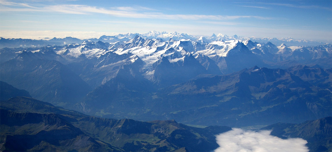
The flight was in clear sunshine and completely smooth. We saw the whole coast of former Yugoslavia, starting with the rugged terrain of Albania, then the only slightly less rugged terrain of Montenegro
Over Albania we encountered that updraught again; it was around +500fpm. Here it shows the IAS at about 140kt; at FL120 one would be doing about 120kt (c. 150kt TAS).
Then came Croatia with its huge number of lovely looking islands.
This doesn't make a very good advertisement for an article explaining how much easier flying is with an IR, but a VFR version of this trip can be seen here and getting past Montenegro and (to a lesser degree) Albania was a stressful exercise, with Montenegro amending the route at the last minute. There is a complicated mass of NATO or similar airspace in that area; when under IFR this becomes irrelevant.
The approach into Padova was via a CHI1 1R STAR from CHI, under Venice Radar control, terminating in the Lctr DME 04 NDB approach. I flew this approach fully for practice but the final 014 NDB track did not work out well; there was a significant difference (about 10 degrees) between the ADF indication and the correct track shown on the GPS overlay. Still, one gets used to 30 degree ADF errors in other places...
Padova airport is really excellent, matched only by Cannes for its slickness and efficiency. It is much smaller than Cannes. It is also getting an ILS soon on 04. We landed and got an immediate taxi to the fuel point, then directions to parking. With close to zero formalities we were through very fast indeed. All GA airports should be like this. There was a number of modern aircraft (Cirrus, etc) parked there, as well as a twin turboprop air ambulance. The airport charges (landing and 3 nights' parking) came to Euro 40 and fuel was Euro 1.98 per litre including VAT.
The old Padova city is full of grand old buildings. We found an excellent newly refurbished hotel, close to the main square but well tucked away, which was Euro 90 per night and which had free internet access, via RJ45 cables rather than wifi.
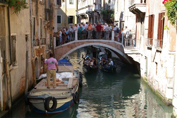
Padova is about 30 miles from Venice, which we visited the following day. We took the train there; a very nice brand new train running on new track which puts British Rail to shame. Getting the tickets is something else; the machines happily gobble up any amount of money without giving change, and there is a long queue at the ticket office. The station names along the route are not necessarily visible, either...
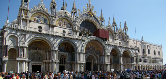
Obviously one day is not long enough for Venice, but it was hard work. Getting around Venice itself is rather like a visit to Disney in Florida: massive queues to get inside any building, overpriced crap food, crap attitudes, and so packed with tourists one often has to hold the camera high above one's head to get a picture
Clearly the time to go there is in the middle of the winter. It is claimed the city is gradually sinking, and one reason must be the weight of the tourists
The erosion which a lot of people worry about can be seen in many places
That said, there are plenty of photo opportunities
Padova to Shoreham
The filed route was (alternate EGMC), FL140:
LIPU DCT VIC B4 DESIP N851 SOPER Z51 KELIP Z651 MANEG L613 HOC G4 RLP B3 BILGO H20 XORBI G40 ABB T27 GURLU Y8 CAMRA DCT EGKA
This is a tricky route because it goes over the Alps, so clouds that are scattered (or better) would be preferred over that part of the route at least. This will vary according to one's attitude to risk but I prefer to have an engine failure escape route most of the time.
As a last-ditch option for this eventuality, I have a handheld GPS that runs some old Jeppesen VFR charts, so one could glide into one of the many deep valleys in the event of an engine failure above an overcast layer. However, the apparent failure of the LS800 at about FL140 dropped a spanner into this; luckily I was able to transfer the map files to run on an HP4700 PDA which I also had. They run under Oziexplorer which exists in both Windows and Pocket/PC versions.
To avoid the Alps altogether, one could do a large detour to the west and then north through France; a long flight if done in one leg. One could land in France, with a slight risk of getting turned over by French Customs who like to pick on US registered aircraft. I do carry the documents including a Certificate of Free Circulation (in original) but in France one can never tell. We managed to escape this unwelcome attention in 2005 (at Cannes) but an "inspection" would take some hours at least and, because Shoreham closes early in the evening, would wipe out the chance of completing the journey on the same day. Currently I prefer to not land in France unless I intend to stay and thus have time to spare. There is said to be an address for French Customs where one could send one's aircraft documents in advance (and prevent these suprise inspections) but despite enquiries I have not found it and it may be an urban myth like so many in aviation.
For the planned Saturday morning departure, the MSLP charts for 0600 and 1200 showed no frontal activity (following a rather active Friday whose MSLP chart corresponds well with the sferics). However, there can still be thunderstorms so the TAFs were examined which showed suspect weather remaining around Zurich (LSZH) in the early part of the morning. The tephigrams along the route 1 2 3 4 did not suggest any organised IMC layer except the first one (Milan) showing something at a low level (3000-6000ft) which would be well below the terrain of the Alps and I would hope to be at FL140 by that point anyway. The 700mb wind map indicated that there might even be a tailwind much of the way...
I wish there was a flight planning website that accepts a route and generates a briefing like the above, for various point along the route! It would save a lot of time. Technically it's easy enough to do; the problem is that 3D atmospheric data is commercially sensitive. The MSLP charts come from the UK Met Office whereas the tephigrams probably come from U.S. GFS data. I guess this is not a bad thing as looking at more than one weather model is useful...
Things got a little difficult even before leaving the ground, when the main IFR GPS, the KLN94, was found to be not working. It was receiving satellites OK but was not producing a position fix. The LS800 tablet computer (fed from a cheap Emtac bluetooth GPS receiver) and the HP4700 PDA (fed from an even cheaper CF GPS from Ebay) both worked fine, but I knew the LS800 was likely to pack up at altitude; it did just that at about FL140. Anyway, I did the instrument departure using navaids and after that I was given vectors anyway. When ATC started giving DCTs to intersections I told them I had VOR/DME navigation only, no BRNAV, so they gave me VOR-VOR tracks which worked fine - until the next VOR given was 150nm away and too far away for reception! I managed OK; if it had been a real issue they would have been more than happy to give me vectors. The KLN94 came back to life after about an hour and has been fine ever since. This will need to be looked at; I noted down the satellite geometry etc but it wasn't the problem because the other two GPSs were reporting loads of satellites with good geometries. The details are here. I have written to Honeywell for their view.
The flight back home was over spectacular scenery. This is a piece of Lake Garda
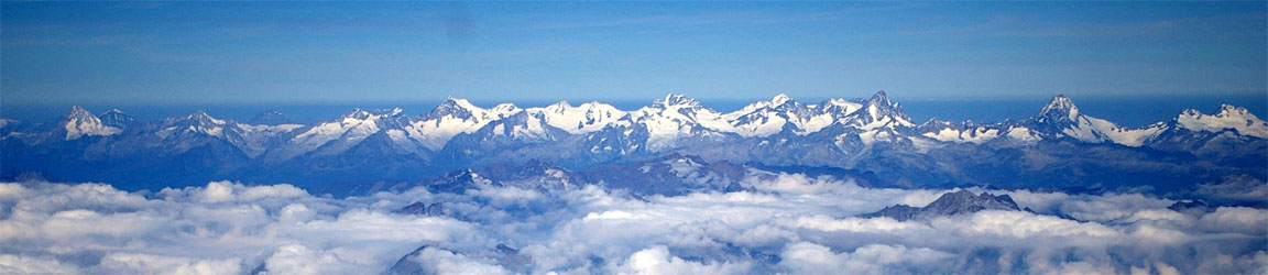
after which one gets some "real" mountains; these pictures were from FL160
An hour later the Alps disappeared into the distance
and the rest of the flight was over what I call featureless Europe.
The flight was filed for FL140 all the way. However, the need to fly VOR tracks increased the MEA to FL160 over the Alps, after which I descended to FL100 and sat there all the way home. The wind ranged from zero (over the Alps) to a few kt of tailwind.
Arrival at Shoreham was straightforward. London Control kept me at FL100; at about 20nm I was getting a bit too close to easily descend so I reminded them; they just gave me a casual "descend out of controlled airspace".
This flight could have been done under VFR, with the proviso that the weather over the Alps could easily involve cloudbases way down into the valleys, and cloud tops extending into the Class C in Swiss airspace (into which I could not get a VFR clearance in 2004). One option is to sit and wait for a cloudless sky, another is to transit the Alps at a low level through the canyons (this is called "mountain flying" and is a whole different game of which I know nothing), and one can wait until airfields along the route are able to confirm the cloud cover and then go. The last option is what I did in the Crete trip in 2004, but we were stuck in Switzerland for a few days. IFR is much easier. However, the risk of flying over mountains under cloud cover is the same regardless of flight rules and a flight like this is likely to get held up anyway.
Observations and Lessons Learnt
IFR flying is great! Not one single thought about controlled airspace, restricted areas, prohibited areas, military zones, danger areas, and no panic trying to find some VRP comprising of a chimney with a roundabout next to it. All the exams, the mad intensive exhausting training, checkrides with crazy examiners who try to distract you, days and weeks of paperwork getting the US Visa and security clearances, endless hassle putting the aircraft on the N register.... it's all been worth doing. Not sure I would do it all again though. One could devise a much better modern process for training a pilot to reach the required standard. The present process owes as much to tradition and job creation as it does to ensuring the pilot meets the required standard.
The LS800 tablet computer packing up at around 14,000ft is a serious problem. It could be extra serious if someone was relying on it to display approach plates. The KLN94 failure also shows the need for a backup GPS which displays intersections properly. I am going to look at getting a FLASH hard drive for it, or perhaps get a dedicated aviation GPS that handles airway intersections well and has a good DCT function.
One of the best things I did was to keep all the flight planning paperwork in one zip-up folder and bring all of it with us to every place we stayed. That makes is easy to fully prepare for the next flight before leaving the hotel. No point in trying to be clever and only bring the bit you think you will need for the next flight. A small thing but it made a big difference. One has to study the SIDs, STARs and approach plates before getting airborne and it's better to have a look at them the evening before, in case any unclear features come to light.
The cloud cover over the Alps on the return trip was well in excess of the forecast - it usually is. I need to learn more about the cloud formation process over mountains. This appears to have little relationship to fronts which can be completely absent, and there may not even be any wind to speak of. Traditional "mountain flying" texts do not cover this since these people fly inside the canyons. I am going on a specialist aviation weather course in September so will raise this.
The oxygen usage needs to be looked at, since two people are going to use up a whole cylinder on one 5hr flight at FL160. A bigger cylinder (or a 2nd cylinder) is a must. I will also get a second Nelson demand regulator. Higher pressure cylinders (especially Kevlar ones) are difficult because one cannot refill them from the standard BOC 3000 PSI cylinders; a boost pump is required. These flights would be marginally feasible with 3 people and would become very weather-sensitive with 4 people.
Think twice about flying VFR, or cancelling IFR, unless fully prepared for what ATC will get you to do; locating VRPs being one "fun" task. You need the VFR charts with you!
An aircraft with a real operating ceiling of much below 18,000ft is clearly of limited use for IFR around Europe.
A funny observation is that my total instrument time on this entire trip comes to under 30 mins. This is what IFR is about: flying in nice weather, out of clouds as much as possible and quite the opposite of what most non-IR pilots would expect.
There was far less flight planning done during this trip, compared with my previous VFR ones. In fact only the VFR leg from Ljubljana to Dubrovnik had to be replanned in the hotel, and flying that under VFR was in retrospect a mistake anyway. All IFR routes were pre-planned back home; this works with IFR because there is very little chance of not being able to fly a route (once it has been checked on the CFMU website) unless an airway is closed on the day, etc. With the exception of getting replies from airports about special requirements (which I know many pilots don't bother with, but I think it's wise) which can take some days to come back, this whole trip could have been pre-planned in 1 short day.
My attempts to get tax free avgas by flashing my AIR BP card appear to have not been successful. That technique works only in Spain. However, it's clear that everywhere I have been (except the UK) you can get tax free avgas (approximately half price) if you have an AOC. I expect this is not lost on the larger flight training operations around Europe; it's worth their while getting an AOC (any old AOC, regardless of what activity it covers) for this reason alone.
The aircraft performed flawlessly.
Update 23/6/2009:
The contact for an overflight/landing permission for Albania is
Mr. Vrioni
MINISTRY OF PUBLIC AFFAIRS
TRANSPORT and TELECOMUNICATIONS
DIRECTORATE GENERAL OF CIVIL AVIATION
CLEARANCE DEPARTMENT
Muhamet Gjollesha Street
P.O. Box 205
Tirana, Albania
Tel +355 42226232
Fax +355 42226232
Update 7/2015:
Some info on other possibly usable GA airfields in Albania are here
Last edited 17th July 2015
Any feedback, reports of dead links, corrections or suggestions much appreciated:
Contact details

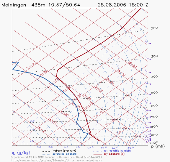
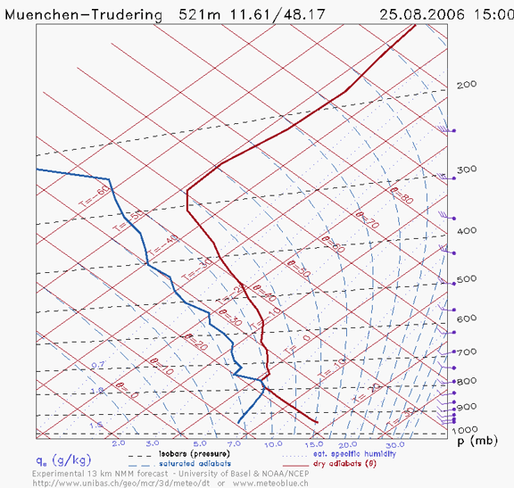
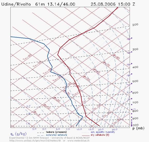
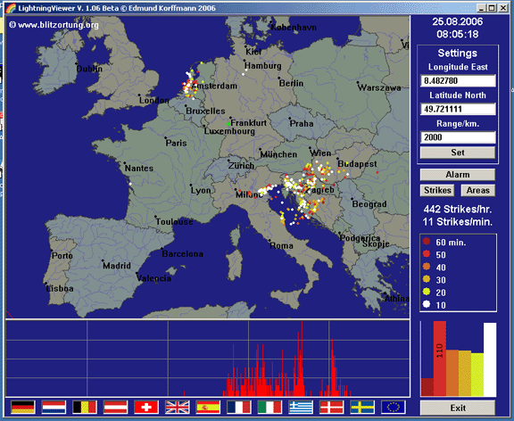
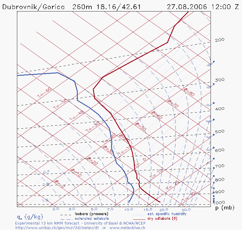
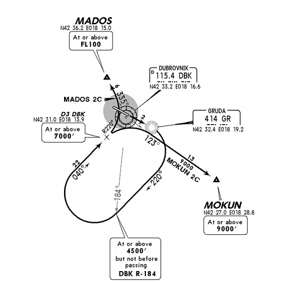
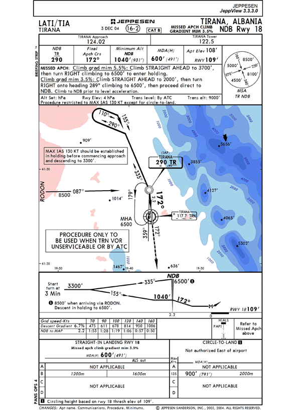
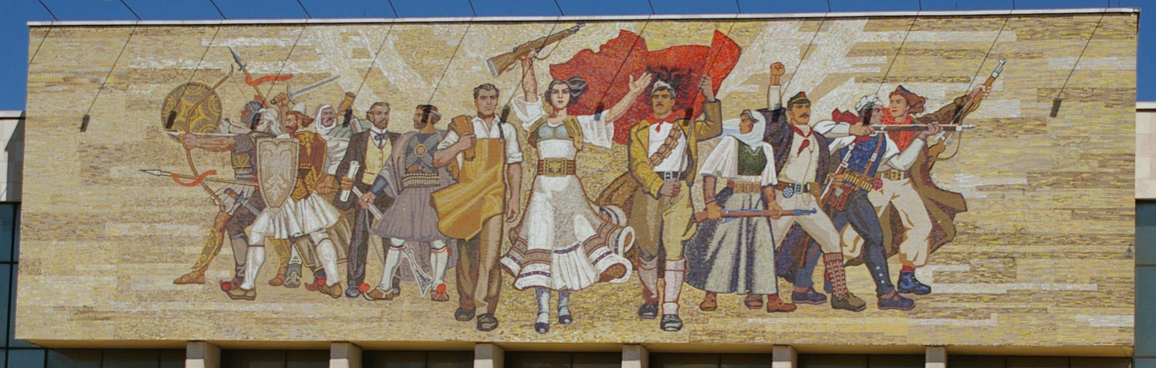
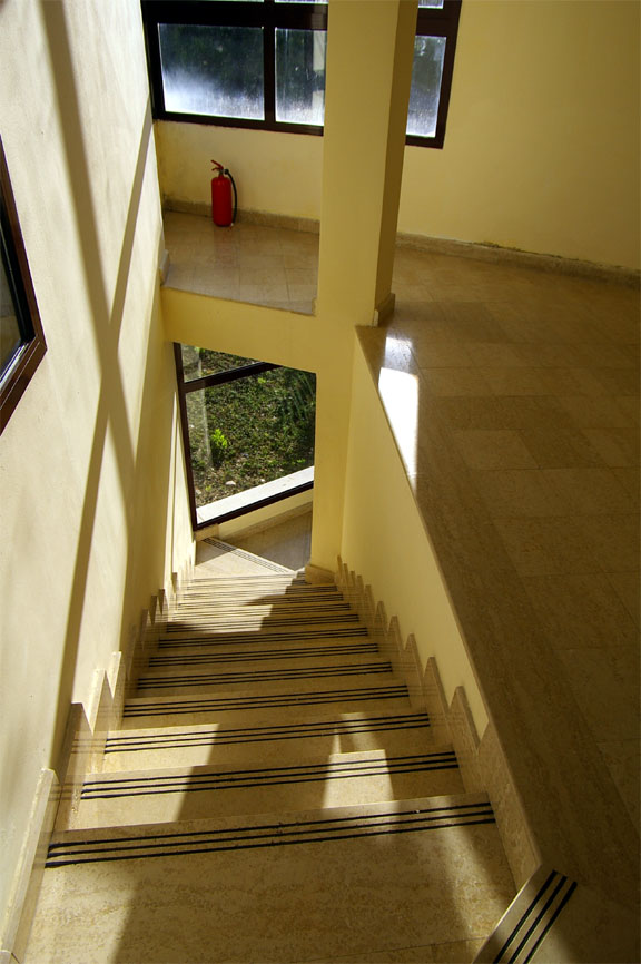
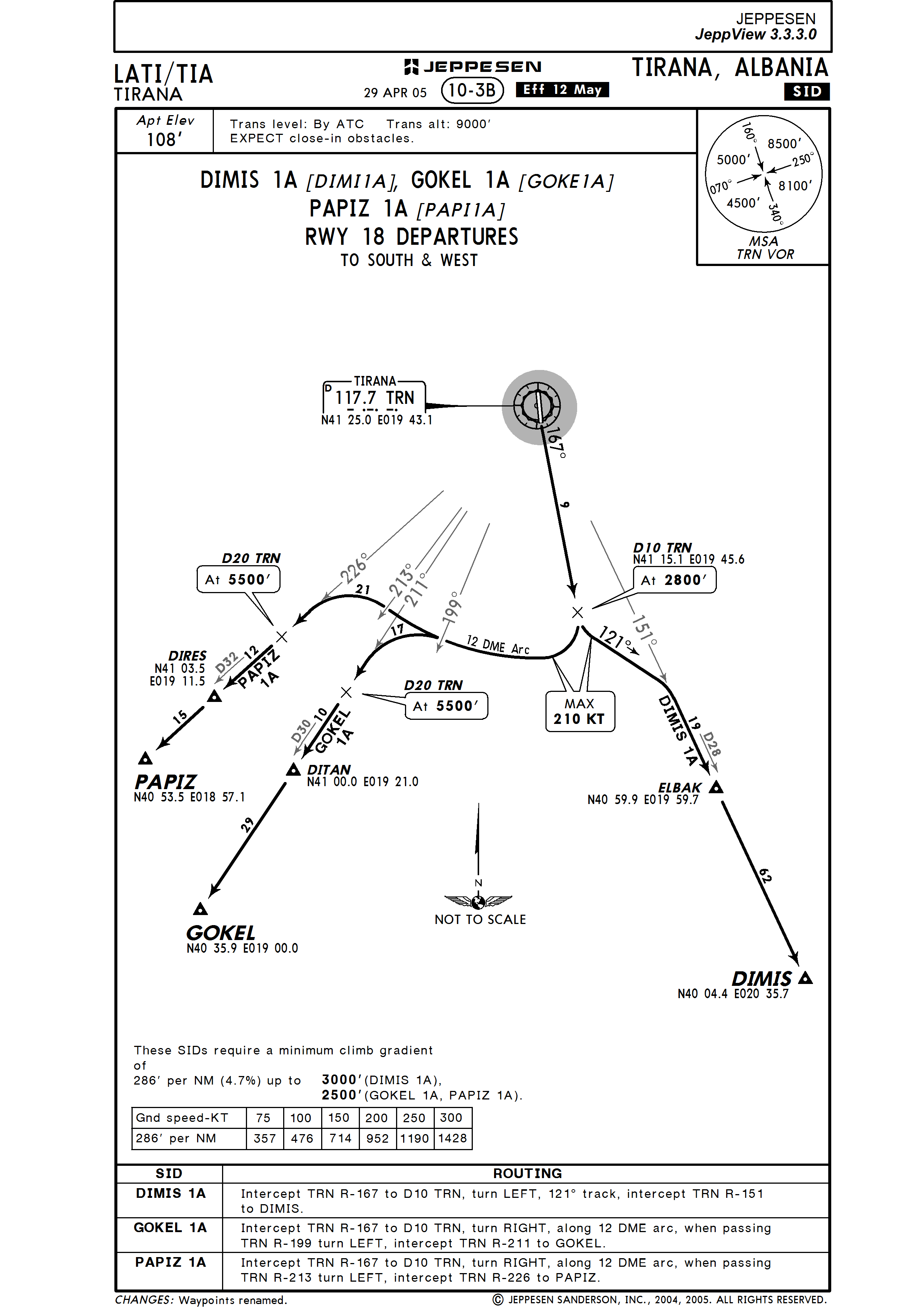
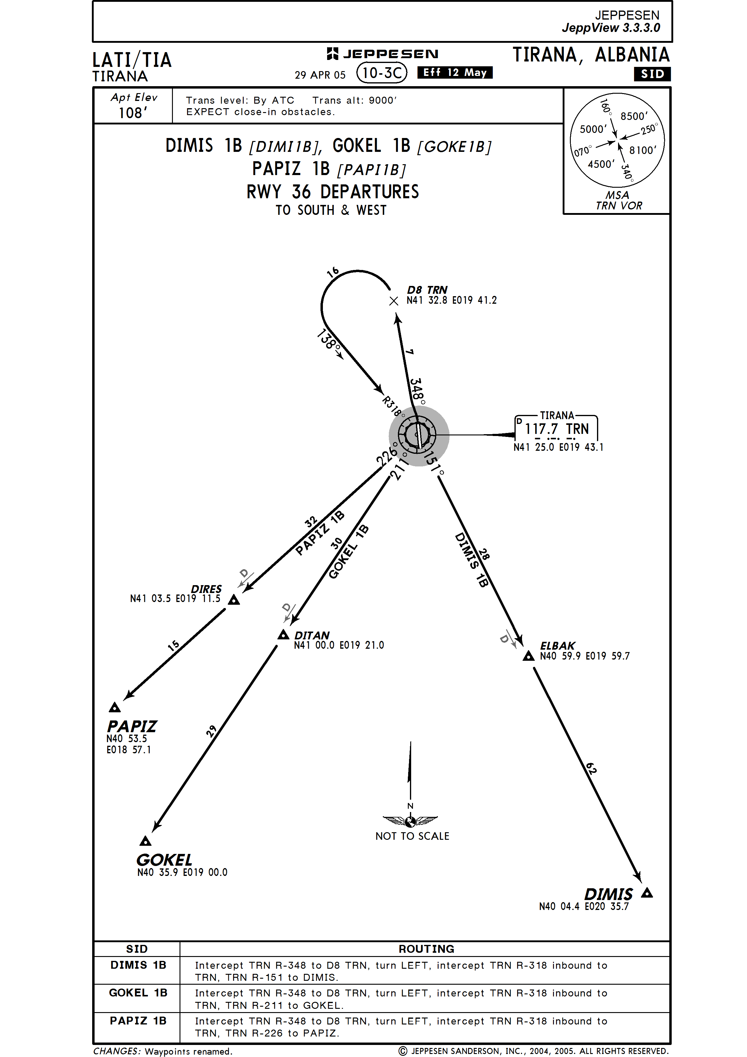
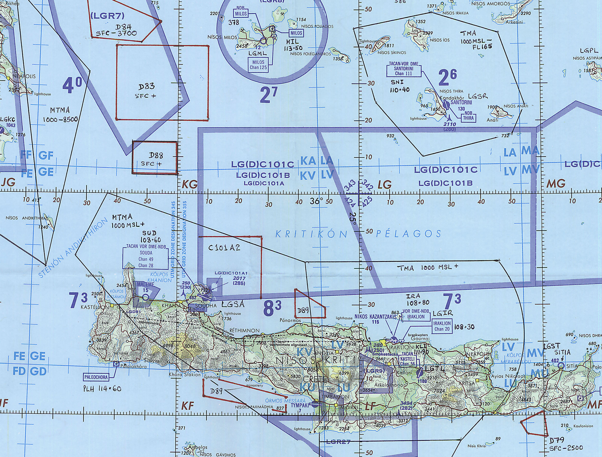
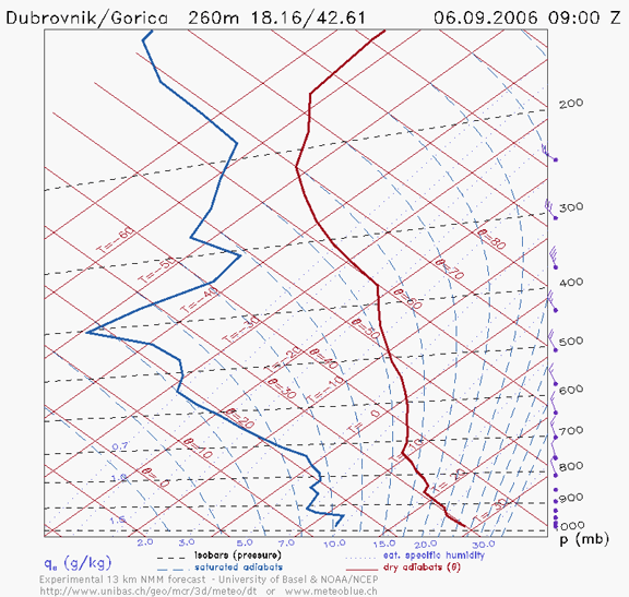
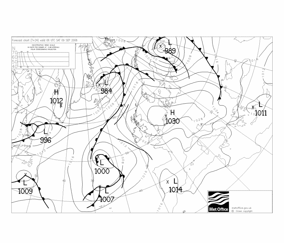
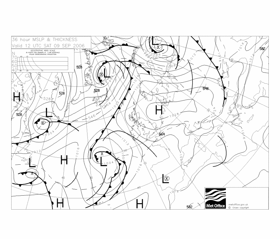
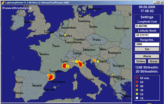
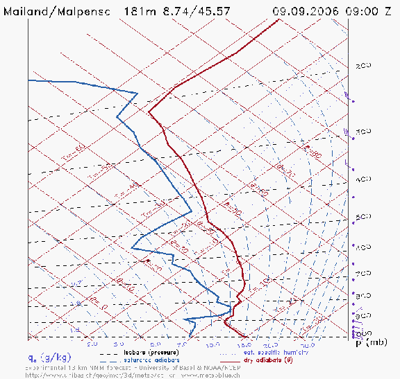
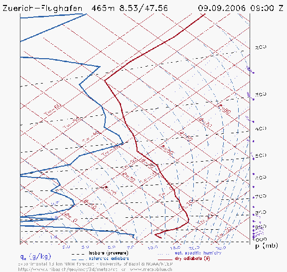
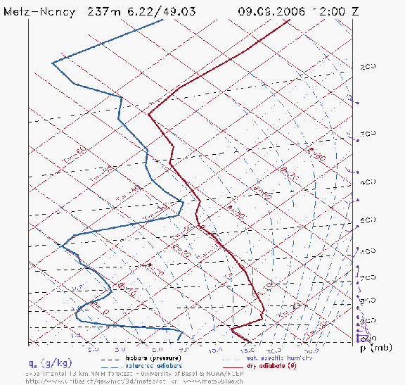
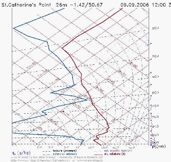
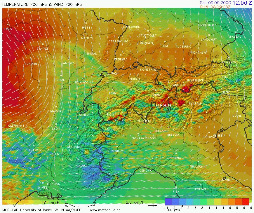