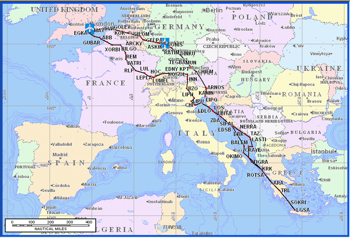
This article describes an IFR trip from Shoreham to Losinj (Croatia), Hania (Crete), Odessa (Ukraine), and back via Prague (Czech Republic).
It was flown mostly under IFR because this is procedurally much simpler and - normally - ensures a much smoother trip.The Odessa part was not achieved, mainly due to last-minute problems with airways routings, and consequently we did not get to Prague either.
A glossary for non-aviation readers is here.
Objective
Geographically, this trip was similar to our previous trips to Greece: to visit a number of interesting locations and to enjoy the views from the air.
The stops were chosen to be interesting enough so that if we were stuck due to weather it would not matter. One also has to choose airports that have both Customs and Avgas; this is harder than one would expect. Finally, the two main destinations (Hania and Odessa) offered commercial flights back to the UK, which was important because my partner Justine had to be back to work on a specific date.
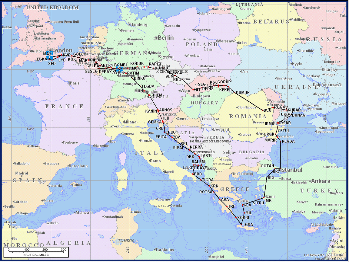
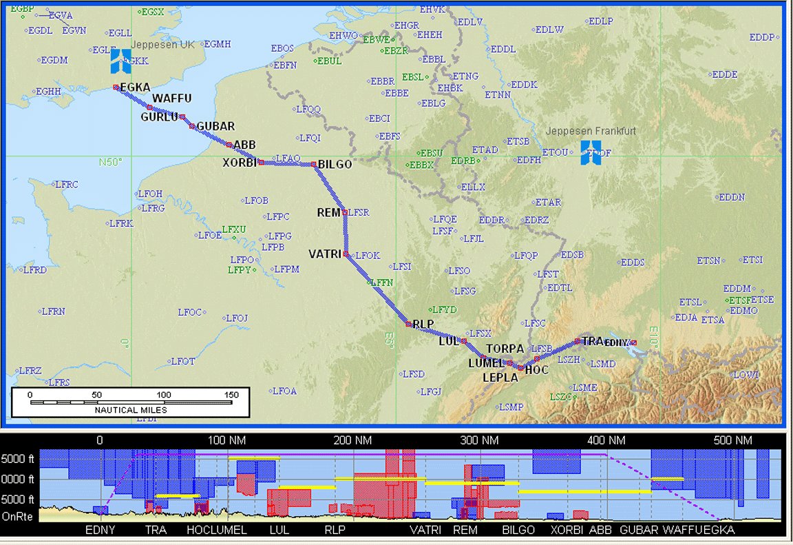
The above map shows the full extent of the flight planned route. The routings appear to zig-zag in places but that's due to the requirement to use airway routes acceptable to the Eurocontrol computer.
The route to the east of Crete would have been new; very few UK pilots have ever been there, and when one looks at the sporadic Avgas availability, this is no suprise and one needs a long range aircraft. The first leg from Crete would have taken us - if flown as per the flight plan - over Istanbul which is half in Europe and half in Asia.
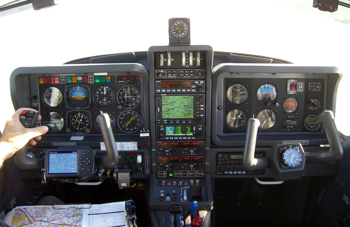
The aircraft is a 2002 Socata TB20GT, with a zero-fuel range (lean of peak engine operation) of about 1150nm, a ceiling of 20,000ft, 155kt TAS at 10,000ft at 60% power. Main navigation equipment is a KLN94 IFR GPS with a KMD550 multifunction display. The aircraft is on the N (USA) register and the pilot has an FAA CPL/IR with about 800 hours total time. The TB20 is an ideal aircraft for this type of trip. It's a 4-seater with excellent load carrying capability but with 2 people and enough stuff for 2 weeks one is not far short of being full in volume if not weight.

Flight Planning
There are several aspects to planning for a trip like this:
1) Working out valid IFR routes
One has to file an ICAO flight plan with a route which uses the airways system which needs to be validated by the Eurocontrol (CFMU) computer in Brussels. Working out this route is often time-consuming because the aforementioned website chucks out routes with meaningless error messages; the printed airway chart does not tell the whole story; some routes are permitted only on some days, some are permitted only for some (local) departures or arrivals, most have permitted levels, etc. The information is contained in various national Standard Route Documents (SRDs), but these don't tell the whole story either. There are several ways to arrive at an acceptable route; my first choice is this ASA website which is very helpful but not 100% successful. I have written a lot of notes on the IFR flight planning process here. Route planning can be a big hassle but once your route is accepted by CFMU you "just" need to fly it! It's remarkable that all the routings on this trip were worked out using the ASA site within half an hour! Edit 3/2009: two new airway route generation tools have been recently developed - Autoplan FlightPlanPro
The IFR route planning process also takes care of terrain clearance, because each airway has a minimum altitude assigned to it. In the departure and arrival phases, terrain clearance is "guaranteed" by the design of the instrument procedure which the pilot is supposed to fly. Nevertheless, countless aeroplanes have been lost due to pilot error - especially in the pre-GPS days. Nowadays, a modern GPS delivers total situational awareness and, to help guard against remaining possibilities, our aircraft has an EGPWS (enhanced ground proximity warning system) which in essence is a terrain database (derived from the U.S. Space Shuttle radar imagery database) against which the aircraft's current trajectory is extrapolated for two minutes ahead, and a verbal warning is generated if there is a terrain conflict. This is not foolproof however since for obvious reasons the warning is inhibited during the approach phase to a known airport.
2) Preparing route packs
I happily use electronic devices when they deliver real value in the cockpit but, for me, the basic flight information still needs to be in hard copy. I use Jeppesen Flitestar for IFR flight planning and, for each leg, I print out the overall route picture, enroute strip sections at 1"=10nm (example - at this scale, one can usually see all enroute airway intersection names) which eliminate the need to refer to the rather cluttered printed airway charts in the cockpit, the plog (example - a list of waypoints, headings, distances, etc), and approach plates for the destination and alternate. For this trip, I ended up with this lot, for the seven flights
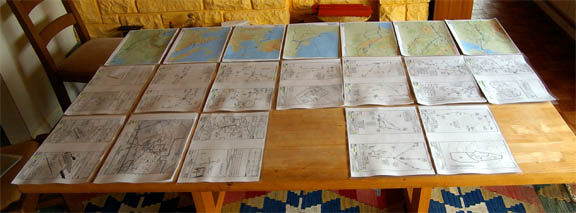
which in total was about 2cm think and this probably represents the minimum one can get away with. Had this trip been done under VFR, it would have been far worse, with the need to carry a large number of VFR charts because of the need for a reference for prohibited or restricted areas and controlled airspace over a potentially large area.
The approach plates were printed out from Jeppview 3 which is another Jeppesen product. Jeppview is basically an approach plate database and a viewer program, but it's latest version includes enroute charts also, bringing it close to Flitestar in flight planning capabilities. It also includes a program called Flitedeck which enables a GPS moving map to be obtained over any database item: enroute chart or approach plate (but not SID/STAR, unfortunately).
It would be great to go "all electronic" and eliminate the paper but the technology just isn't there yet. Conventional tablet computers are way too powerful and suffer from excessive heat generation, inability to work at altitude (due to hard drives crashing), and the general unreliability of anything running that bloatware called Micro$oft Windows. The Iliad from Irex - basically, a dedicated unix-based "electronic book" PDF display device, with FLASH storage, and a revolutionary paper-like display technology - very nearly delivers but thanks to a stupid design of its PDF display program it is not quite able to display a whole approach plate in a readable manner. I have one of these and have found a replacement PDF reader for it, but one is still left with a crude user interface which makes page selection too slow for airborne use. It's very close, though, and with a custom user interface and some automated means of generating one-per-page PDFs out of Jeppview (and an index) it would be OK. One would still need two of them, in case one packs up.
In the cockpit, I run a Motion LS800 tablet computer which uses its own GPS antenna and receiver and which acts mainly as a backup for the aircraft's IFR GPS, and can run VFR and conventional topographic charts for emergency situations. This has Jeppview on it and could thus be used to display something which I did not have in hard copy. Without such a device, one would end up printing out approach plates for many possible enroute diversions, which would be truly wasteful.
3) Immediate preflight activities
This involves checking weather, notams, and filing (usually by fax) any notifications that a destination airport may require.
A top tip, VFR or IFR, for outside the UK, is to fax every airport in advance:
Aircraft reg and type (including the ICAO code)
MTOW
# of passengers and their nationalities
A range of dates for arrival and departure
Avgas and Customs availability?
PPR requirements and acceptable methods of transmitting the request?
Phone and fax number of ATC?
Anything else I need to know?
Please hand-write your reply on this fax and fax it back, or email to xxx
The responses are often suprising. A lot of the information published in the flight planning guides (Jeppesen, usually) is fiction; I think a lot of the information in the national AIP (which is where Jeppesen etc compile their guides from) is rubbish. By the time you get to Spain, Italy or beyond it's common to find a duff phone/fax number. There is no substitute for getting the information from the airport directly. Fax numbers change a lot less often than phone numbers.
One alternative to the above, favoured by regular business and commercial pilots, is to simply contact the handling agent at the destination; for their fee they should be able to sort things out. In "hard" cases (the real Third World) one would use a specialist overflight permit company.
One can get contact numbers from various flight planning programs, e.g. Jeppesen Flitestar or Jeppview, or from the national AIP. These tend to be unreliable and the Acukwik handbook is a slightly better source. Ultimately, however, the airport details just get lifted from the national AIPs which limits their accuracy. I would guess that the handling agent details in Acukwik are fairly accurate though because that is the typical usage of this resource.
With notams, enroute information is much less important than under VFR because the route flown is normally under ATC (radar) control all the way. Airport notams remain crucial however and occasionally turn up non-working navaids and thus unavailable instrument approaches.
Some notes on IFR weather planning are here. For notams, I use the official UK site which carries the entire international database of enroute and international airport data.
No VFR airfield guides are required; the standard approach plates include an airport diagram and other relevant information. If however one was to ever cancel IFR, one will be thrown right back into the "VFR world" and suddenly one needs all the VFR airport charts, approach diagrams, a means to suddenly navigate to any VRP, etc. Never cancel IFR unless unavoidable!
Long trips like this one do not need a great deal of forward planning; a couple of days in advance is plenty. However, kicking off the process of extracting the essential information out of airports a few weeks early is a good idea. Some never reply and have to be telephoned, which can be a problem if the published number is the recorded information line for scheduled flights.........
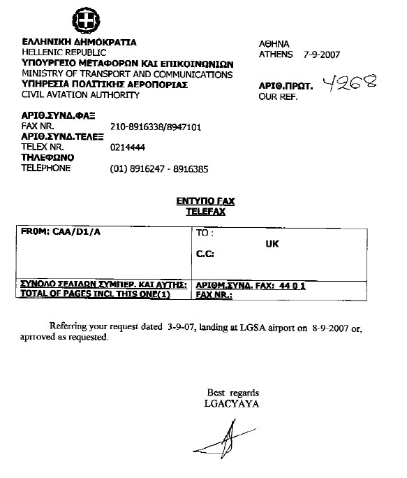
On this trip, the hardest notification requirement was Hania (LGSA) in Crete which being partly military has a 5-day PPR (prior permission required) for both arrival and departure. This is difficult to comply with. I had a long string of fax correspondence with different bits of the Greek CAA in which I never got the same answer twice, with the PPR period varying from nothing to two weeks. Eventually the confirmation arrived. Edit 2010: LGSA PPR is now listed as 20 days, so watch out...
Mobile Computing & Communications
This is essential when doing a long trip. This kind of flying - VFR or IFR - is a long way from that of an airline pilot who steps into the cockpit having just been handed a folder with all he needs to know. The private pilot needs to be able to plan flights, get weather, file flight plans, fax prior permission (PPR) notifications, print out approach plates and enroute charts, etc. One can manage without this but then one ends up hanging around in smoke-filled internet cafes and messing about at airports where nobody (that can speak English) knows where the pilot information service is - if indeed one exists. All this is especially inconvenient given that - for weather reasons - most flights depart early in the morning and there is no time for messing around. Finally, many private pilots are business or professional people and need to stay in touch with the office, using email, etc.
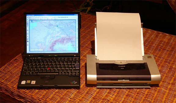
I have a Thinkpad X60S-1704 lightweight laptop which has a built-in GSM/GPRS/3G adaptor and a great 7-hour battery life. With this I also use a Sierra 750 PCMCIA GSM/GPRS adaptor which serves two purposes: it can be used for sending faxes (although I prefer to use an email to fax service for this) and it contains a different network's SIM card for redundancy (the laptop is on Vodafone and the Sierra 750 is on Virgin). Network redundancy is important because in many places there is internet connectivity with one and not with the other. For the occassional printing requirement, I use the Canon IP90 lightweight colour inkjet printer. The whole lot easily fits into a small backpack and transporting it to the hotel is not an issue. The printer doesn't get used unless there is a major route re-plan and new enroute charts or approach plates need to be generated. One would never use the IP90 at home because it eats inkjet cartridges at an amazing rate.
The laptop also has WIFI but unfortunately one cannot rely on WIFI to the extent the popular media might suggest. Nowadays (2007) most city/hotel networks are secure and if you can find one you have to pay for it, sometimes with dubious recurring credit card charges. It's also common for a hotel to have a "free" WIFI network but nobody can find a working password... Walking around some foreign town with a laptop under one's trenchcoat, covertly searching for an unsecured WIFI network, might attract attention. I have consistently found that spending the extra money on getting weather data etc via a GPRS/3G connection is a whole lot easier, and very often is the only option. Some notes on mobile connectivity are here.
I also carry an HP4700 PDA which can use my Nokia 6310i mobile phone as a bluetooth-connected GPRS modem; this is handy for e.g. checking the following day's weather while being out and about, or checking weather immediately before departure. For emergencies, it will do full internet access in 640x480 screen size which is OK for most websites.
Finally, one can get TAFs and METARs via WAP directly on the mobile phone, and many UK pilots do this. However, I found that in some places this fails - even when the phone works fine as a GPRS modem for the PDA. The explanation for this probably lies in the bizzare combinations of WAP over GSM or WAP over GPRS which are supported to different degrees around Europe.
Shoreham (UK) to Losinj (Croatia) - with a stop in Trieste (Italy)
The first flight - getting out of the UK and its constant stream of frontal weather - is nearly always the most tricky, especially as one needs reasonable weather over the Alps. Once south of the Alps, things tend to be more predictable. We have found that the best way to manage this is to make the departure date flexible, have everything packed, and review the situation continuously. When it's good to go, one goes for it - even if the following day's weather "looks" a lot better.
The best tactic for IFR flight at levels below FL200 is to ensure the flight can be done above any cloud tops. These appear on the SigWx form and can also be estimated from the data on several weather websites. Flying in cloud long-term is not on because the temperatures at airway levels will usually be below 0C and eventually too much ice will be picked up; there is also turbulence and - without weather radar - one could fly into some nasty vertical build-ups. I have a stormscope (a device which detects lightning discharges and indicates their direction and approximate distance) but this can be relied on to detect only quite nasty turbulence or worse. Admittedly this is a rather simplistic weather strategy but it works well.
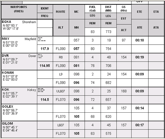
The airway route was
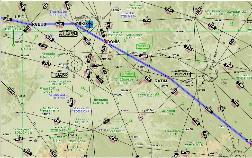
EGKA MAY R8 DVR L9 KONAN L607 RUDUS L984 ASKIK Z74 DONIS L603 CHIEM P995 ARNOS
L607 ILB P81 CRE LDLO (Alternate: Pula LDPL)
FL150 (lowest valid route level was FL145)
Distance: 700nm GC, 773nm airways
Flight time: 5 hours
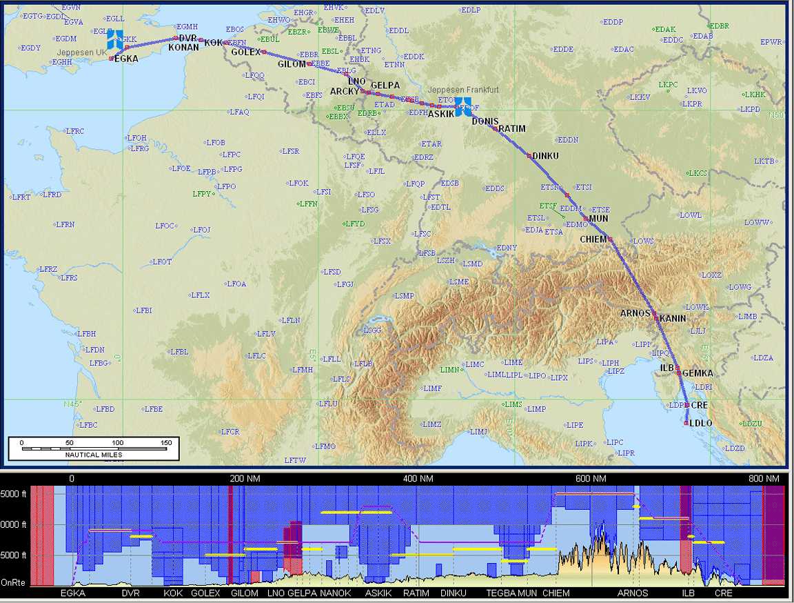
Warning: This article includes route illustrations (like the one above) produced by Jeppesen Flitestar/Flitemap, which include a vertical (terrain) profile at the bottom. It has recently come to light (details) that the Jepp terrain elevation data is grossly inaccurate and can be several thousand feet out. Furthermore, the error is usually in the unsafe direction. This feature of the software is therefore useless for any flight planning or terrain avoidance purpose, even in an emergency.
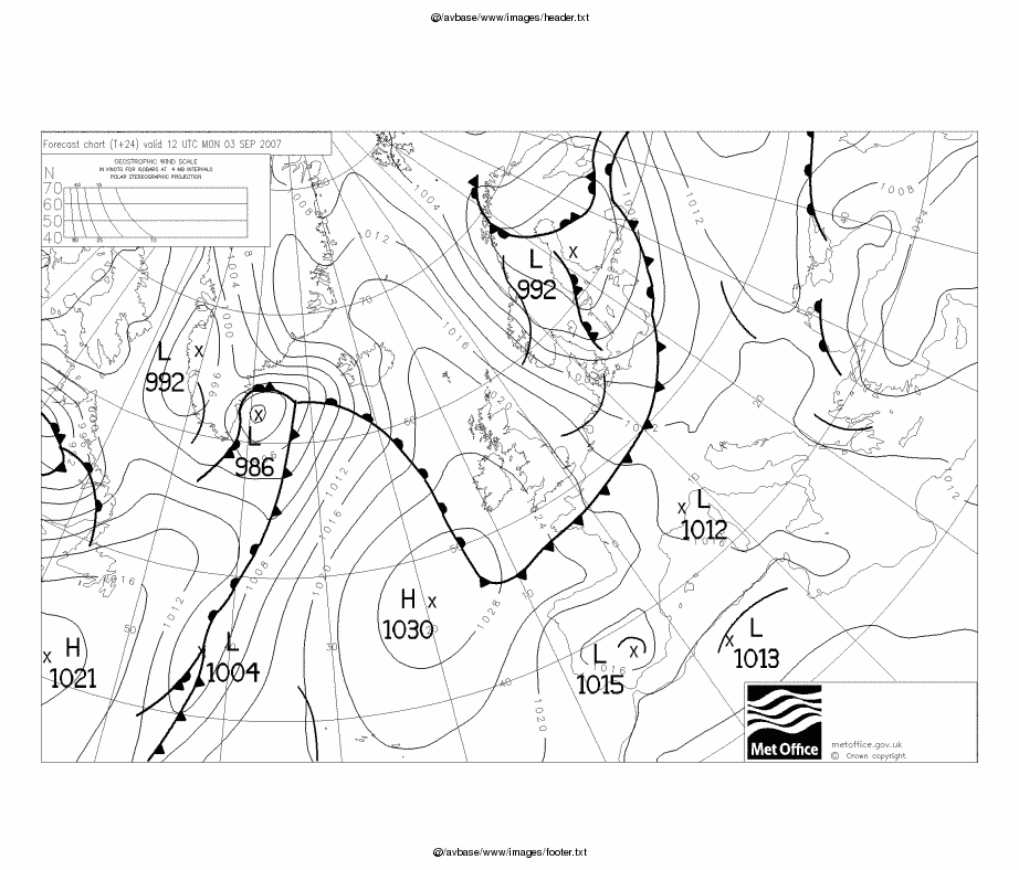
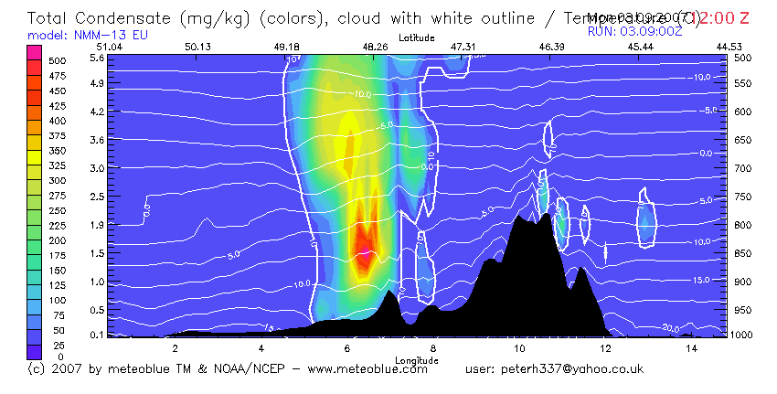
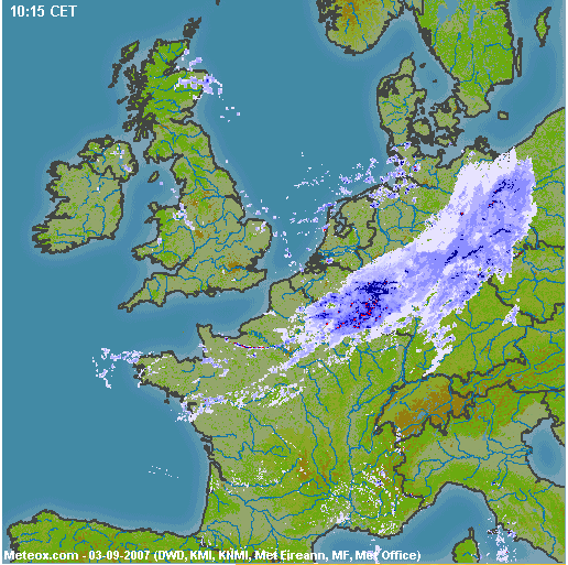
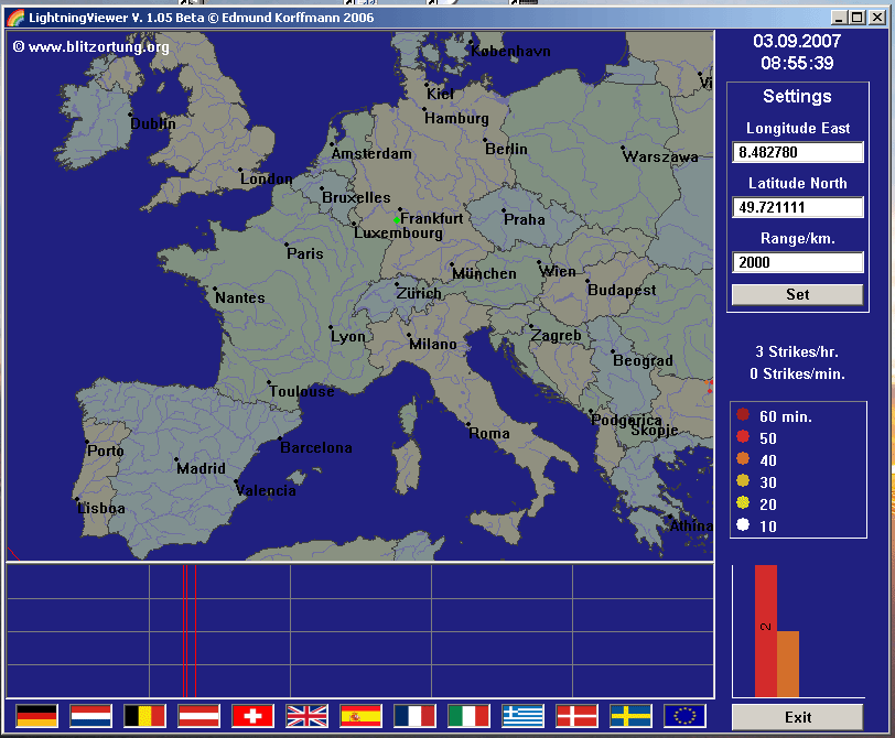
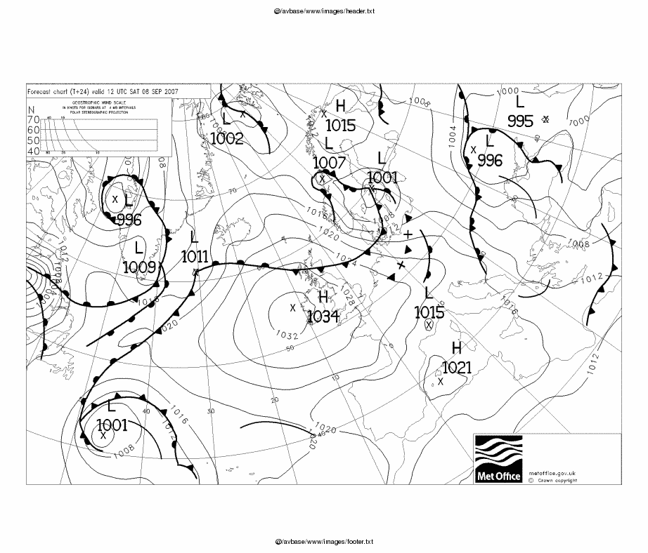
The weather did not co-operate. The planned departure on a Monday was scrapped due to a big front hanging over central Europe, with cloud tops determined to be above the aircraft operating ceiling MSLP SigWx Skew-T (actual ascent taken through the front in an earlier position) and finally the forecast from the Meteoblue route cross-section. On the morning of departure the decision was confirmed by the radar image in which solid returns are usually a no-go due to both cloud tops and convective activity. However, there was no lightning at all so a bold pilot could have flown it in IMC. He would have needed a de-iced aircraft though - the 0C level was around 7000ft. One could have hacked it - all the way to the start of the Alps, anyway - below the 0C level but what happens then?? A re-route initially directly south would have been another option but there are no Eurocontrol routings available (at practical levels) through the Paris area.
On Tuesday things looked better: MSLP 1200 1800 SigWx 1200 1800 Route-Cross-Section TAFs radar-Europe radar-Italy. There was slightly questionable weather at the destination but it looked like the cloud bases would be high enough to be OK for the descent section. I had filed the flight plan the evening before and it was accepted.
Then, around 0600Z on the morning of the flight (Tuesday) I received an email with a Eurocontrol slot delaying the flight by an hour, which given the 1400Z closing time at Losinj made the flight close to impossible... So I quickly re-worked the route to a familiar international airport close to the route - Trieste LIPQ - and filed a flight plan with it. Then, after I cancelled the original Losinj flight plan, another slot time arrived, 30 mins earlier than the previous one, closely followed by another slot which took the departure close to the original one!!! But it was too late to change... So, we went off to Trieste.
In retrospect, a much smarter procedure would have been to file and fly the original route (to Losinj) with Trieste as the alternate, and bank on the expected tailwind to make up for the lost time, diverting to Trieste if the ETA for Losinj (which, in terms of flying time at say 160kt, is only just down the road from Trieste) was showing to be too late. The KLN94 will forecast the ETA to destination very accurately; in the last 30-60 minutes of a level flight one can expect it to be within 1 minute.
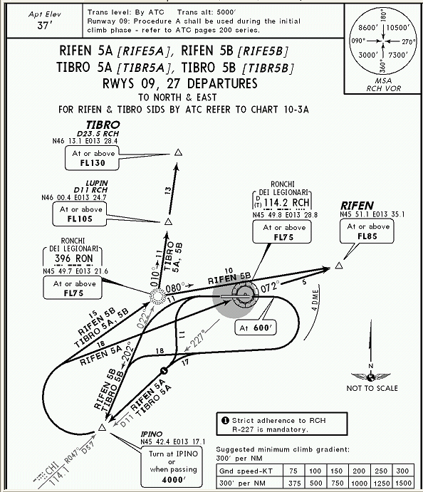
The route to Trieste was the same as the Losinj route except the end was slightly different to get CFMU acceptance
EGKA MAY R8 DVR L9 KONAN L607 RUDUS L984 ASKIK Z74 DONIS L603 CHIEM P995 ARNOS P125 TIBRO LIPQ (Alternate: Pula LDPL)
The required modification (around TIBRO) is not at all obvious but was worked out immediately using the ASA website for an EGKA-LIPQ route.
After departing in clear weather from the UK, the conditions turned out to be little more than a passing resemblance to the SigWx and the other forecasts. Some of the TAFs may have been "not wrong" but they don't forecast anything above 5000ft anyway. It's usually impossible to fly IFR (at Eurocontrol levels) below cloud - VMC on top is the only way. There was a more or less solid overcast from Belgium onwards, all of it with icing temperatures, with tops gradually climbing from FL100 to FL170 over Germany, reaching FL185 around Munich.
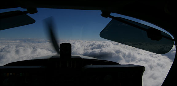
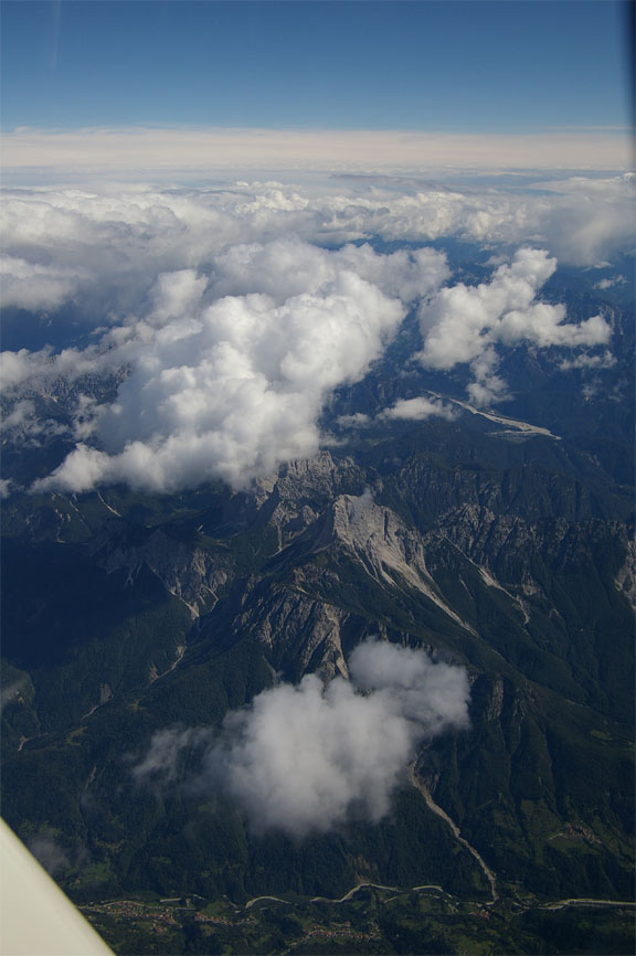
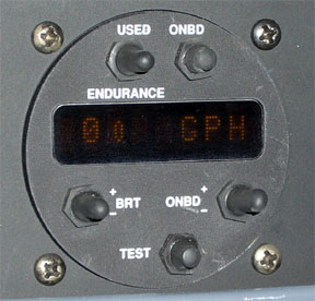
In places it was fairly thin - maybe 3000ft - but was thicker over the Alps, almost completely shrouding the tops of the peaks in cloud. We climbed as required to FL190 - impressive performance for the non-turbocharged TB20 which was still delivering 140kt TAS (at 9-10 GPH) and with the IAS about 25kt above Vs (the stall speed) appeared well capable of going higher. The lowest OAT was -22C. The average ground speed was about 160kt.
There was no issue with the Alps being covered in cloud (many pilots would worry about an engine failure) as we were about 10,000ft above any of the terrain and with the aid of a second moving map GPS (running on an LS800 tablet computer) constantly running a VFR chart (under Oziexplorer) we would have been able to glide into one of the many canyons.
The effect of the ~ 20kt northerly wind flowing over the mountains was only just felt at the level flown, with no turbulence most of the route and very light turbulence near the end.
We used up about 2/3 of the first of the two oxygen bottles we were carrying, which may or may not be a problem later on. I also discovered a significant issue with the Nelson / Precise Flow mechanical demand regulators: they use the exhalation to shut off the flow of oxygen. It's clear they use the inhalation to open up the flow, but if your exhalation is a bit lazy then the oxygen flow gets shut off very late (which is pretty inefficient in terms of saving gas), and if you have removed the cannula before exhaling then the oxygen just keeps coming out indefinitely... I can see why they did it this way (it avoids having to spring-load the pressure sensing diaphragm) but if one of the users of the system removes their cannula there is about a 50% chance of ending up with a constantly open flow and one could easily waste a whole bottle of gas. This is another reason for going for the much more intelligent Mountain High electronic demand regulator - despite its requirement for batteries and its suspect failure mode which shuts off the oxygen totally. Some notes on oxygen systems are here.
The cloud cover thinned out at the end of the Alps crossing
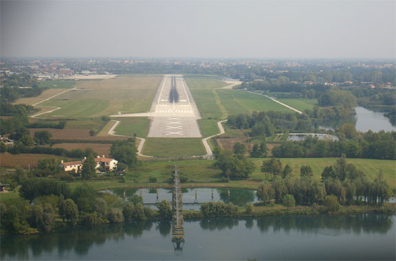
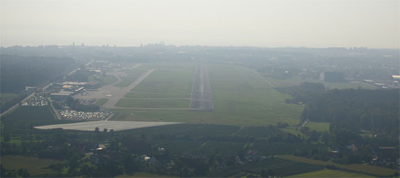
The descent into Trieste (called Ronchi as the city of Trieste is some distance away) taking place more or less immediately after the last of the Alps peaks, was good fun. From FL170 (about 30nm earlier, ATC requested a descent from FL190 (and forcefully refused a delayed descent request "due to following traffic") but did allow lateral deviations as required) we had to do a number of orbits to get down to 3000ft, even when descending at -2000fpm. Engine management ("shock cooling") was not an issue since the power output at FL170 was very low and its temperature was low. We landed with a visual approach on runway 09, landing a long way down the runway so as to get off the runway quicker because a jet (Ryanair) was waiting to depart.
After all the hassle with Eurocontrol, the flight itself was uneventful.
There was significant tailwind most of the route, averaging perhaps 20kt, resulting in a flight time of 4:35. We landed with 36.1 USG in the tanks, closely matching the 36 USG forecast by the KLN94/Shadin flowmeter instruments while enroute, which made it unneccesary to refuel for the onward flight to Losinj (about 80nm). Accordingly, I did not establish whether Trieste has modernised its Mad-Max avgas pump with which we were acquainted in 2005.
Had we continued to Losinj, we would have made it there well before it closed, so the Eurocontrol slot did nothing but mess up the journey.
Trieste airport is big enough to park the whole of the RAF and is fast to get out through; we were picked up with the minibus and straight through the airport in minutes and caught the #51 bus into town, for Euro 3 per person.
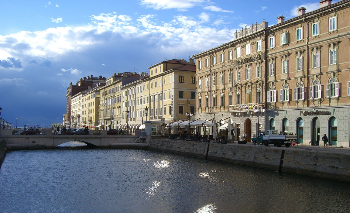
Trieste is a lovely old European city, somewhat resembling Prague but with a seafront. I have already written about it from our previous visit there in 2005 on the way to Santorini. This time we had just one complete day there; we visited a huge cave which claims to be one of the biggest in the world. The city has excellent public transport, with most bus journeys costing 1 or 2 Euros - a small fraction of what one pays in the UK.
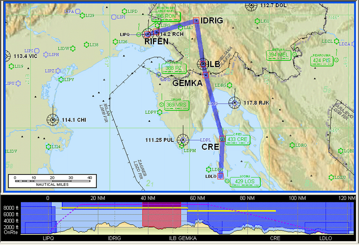
Trieste (Italy) to Losinj (Croatia)
The IFR routing was
LIPQ RIFEN A21 IDRIG M178 ILB P81 CRE LDLO
(Alternate: Pula LDPL)
Lowest acceptable IFR level FL090
Distance: 85nm GC, 111nm airways
On the day of departure (Thursday) the weather was not really suitable for IFR. The SigWx data suggested tops at FL210. The local picture did not appear to confirm this cloud thickness, with the sun being clearly visible through, although the data from a subsequent ascent did confirm the thickness to a degree, at least in one spot. The biggest issue however was that the relevant SID for Trieste had a minimum final level of FL085 which was clearly going to take us straight into the cloud where we would have sat for the whole route, and the likely 0C level did not make this a good proposition. Some lightning was also showing up, suggesting significant vertical development in the clouds. Finally, the length of the SID would have increased the total distance to about 140nm - ridiculous for a 85nm direct distance.
The TAFs showed that low level VFR flight was clearly possible, and that was what we did.
I checked at the GA Office at the airport whether they had our VFR flight plan. They replied that they see only IFR flight plans on their screen but they telephoned the tower and the tower confirmed that they had it. However, when we were all set to go, the tower said they did not have any flight plan for us. They somehow managed to lose both ours and another one for an Austrian fire-fighting helicopter who, it turned out, also uses Homebriefing. However, the FOLLOW ME driver was extremely helpful and took my flight plan printout to the tower where they re-filed it and then came back to me to confirm it was done, which was really nice.
The departure from Trieste was straightforward, runway 27 and a left turn to a VRP called VICKY which lies on the track to PZ. VRPs are always a problem in VFR flight but this time I had a GPS which showed all the "official" ones. The flight was at 3500ft and apart from very slight turbulence in places was very pleasant as we passed over the picturesque Croatian coastline.
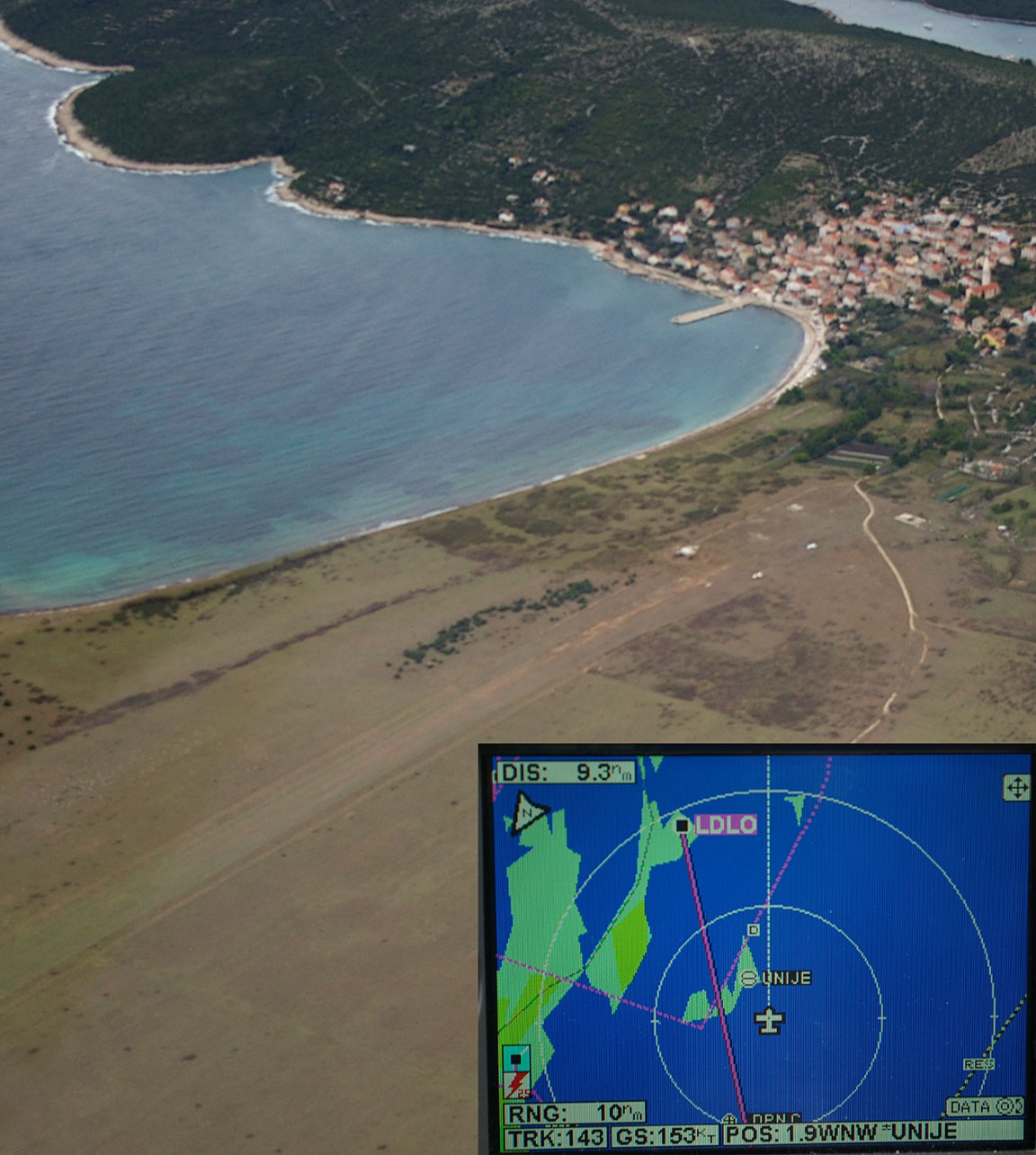
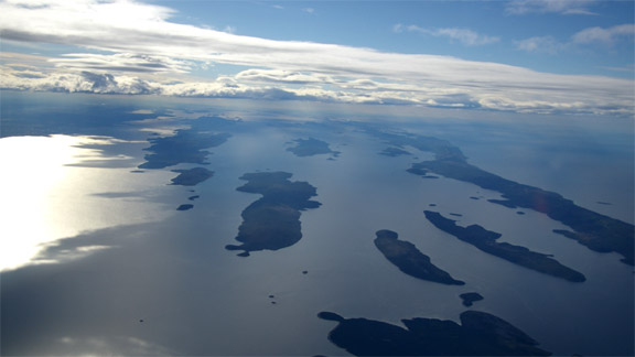
About 10nm before Losinj we passed a small fishing village with a grass strip named Unije, where several light aeroplanes were parked
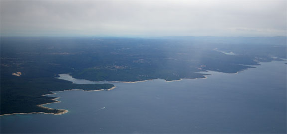
After Pula (whose controller we had been speaking to) we were handed over to Losinj Approach. The flight was a quick 45 mins and soon the Losinj island (the further one in the following pic) appeared ahead.
The final approach (runway 02) was quite windy (020/14G25) but OK
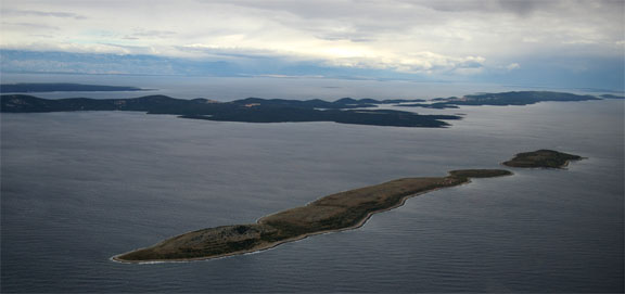
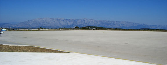
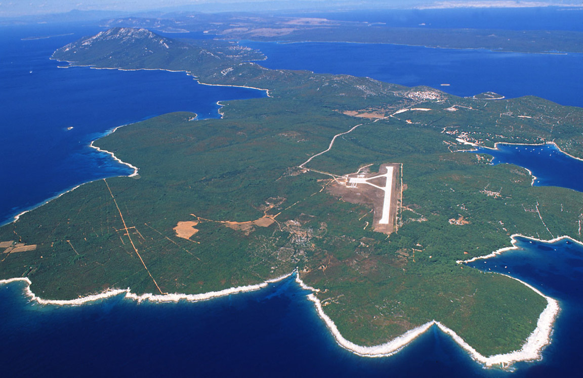
Here large pic is another pic of the Losinj island showing the airport - I believe this image was emailed to me by the airport office.
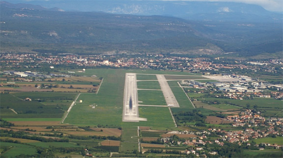
The airport is an amazing little place - a little more than a wooden hut or two dating back to Marshall Tito - staffed by two of the most serious looking policemen (armed of course, as is the custom in Europe excluding the UK) who most carefully examined and stamped our passports, one man who did marshalling, refuelling with a bowser, and tying-down the aircraft (the first time the TB20 had ever been tied down) and two very helpful office staff, who phoned up a couple of hotels for us and one of whom took us into town in a minibus. Notably, Losinj is one of the very few airports anywhere that is capable of communicating using email...
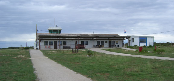
It didn't look like there was any traffic there all day. For its tiny size, Losinj is a full international airport with police and customs, and clearly does not need the "European treatment"; one of the most stupid examples being Norwich Airport where the idiotic security procedures include confiscation of toothpaste carried by light aircraft pilots. The runway is too short for jets and they do need a longer runway to bring in more tourist traffic. The avgas price was just over Euro 1 per litre which is by far the cheapest I have seen since I managed to get some tax-free avgas in Spain using an AIR BP fuel card with a limited company name on it (a practice which doesn't work elsewhere unless the pilot produces an AOC). Losinj is more limited in payment methods, accepting cash, Amex or Mastercard and notably not Visa.
The following remains a mystery...
The main town, Mali Losinj, is very picturesque and in the right weather (it was cold during our stay) would be a great place for a laid back holiday. Most of the tourists are Croatian but there are also many Germans. Thankfully there was no sign of the British "fish and chips" crowd. The food was excellent with plenty of great seafood around.
We were tied by the date-specific PPR requirement at Hania and consequently the need to depart from Losinj after 2 nights. Had we flown direct from the UK to Losinj, we would have had 4 nights there. The permission from the Greek CAA arrived only on the morning of the last day at Losinj (by fax - one really does need a means of receiving faxes while travelling when dealing with these 3rd world government agencies). The permission specified an arrival on the day we told them about but did not appear to tie us to a specific departure date from Hania.
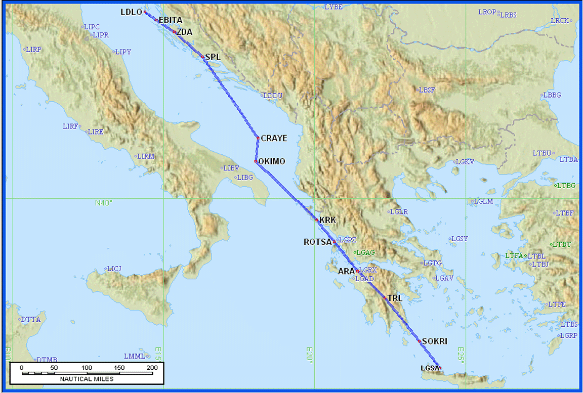
Losinj (Croatia) to Hania (Greece)
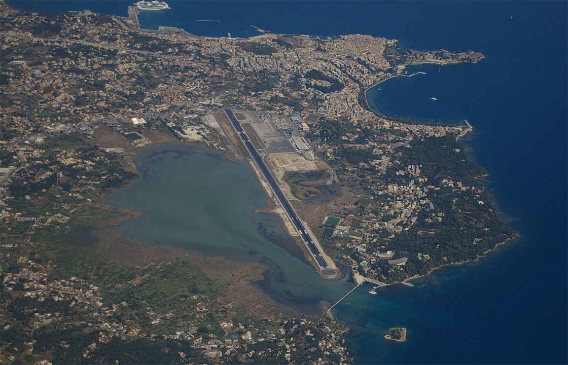
Hania (LGSA) is also referred to as Chania, or Souda Bay which is the name of the U.S. naval base there.
Like all flights on this holiday, this flight was pre-planned IFR back home with this route:
LDLO EBITA N606 ZDA L607 DBK A48 BRD A14 TIGRA L995 KRK A14 ARA L612 TRL J65
SOKRI LGSA
Alternates: Iraklion LGKR, Sitia LGST
Lowest acceptable IFR level FL100
Distance: 702nm GC, 808nm airways
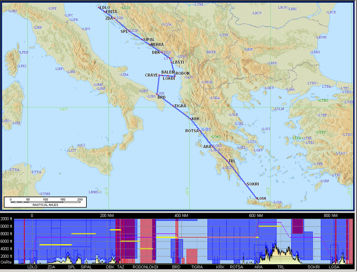
The route contains a silly dogleg between RODON and TIGRA. This could have been avoided but only with another equally long over-water routing which still went to Italy and back, and since the airspace between these two waypoints belongs to Montenegro or Albania whose ATC has in the past been helpful, I had banked on getting a direct route between the two. It appears possible to do such a shortcut on the airways routings but for some reason CFMU was rejecting it.
Hania appeared the most difficult destination on this trip because it requires a 5 day PPR for both arrival and departure (in theory, anyway). This brings a real possibility of being stranded there if the permissions runs out due to unsuitable weather for either arrival or departure. We did check commercial flights and it appeared quite easy for Justine to fly back direct to the UK on any of several airlines. For me, other options in the event of a landing refusal at Hania were Iraklion (from where we could get a bus to Hania) or Sitia (a lovely town at the other end of Crete, but a bit too far away to see the Hania area via road transport); both of these have avgas and are also permitted as ports of entry to/from Greece.
On the planned day of departure the Losinj weather was continuously improving and the weather enroute looked good: TAFs MSLP SigWx 0600 1200 and for good measure I looked at the USAF Icing Hazards.
Losinj airport opens at 0600Z and we departed at 0700Z. Paying the landing and parking (total about Euro 25) took only minutes and we were airborne on the EBITA1C SID, and soon handed over to a radar service where we remained for the rest of the flight as is usual in IFR. We flew over the countless islands along the Croatian coast
The flight was uneventful but as if often the case the weather bore no resemblance to the SigWx data as far as the vertical extent of the cloud cover was concerned. There was scattered / broken cloud at various levels to about FL150 along the entire route but we managed to stay clear of it by heading changes while remaining at FL110-130 to conserve oxygen. In general, it's always preferable to fly above cloud than below it because flying below it would enable it to thicken (without this being visible from underneath) and then if the cloudbase lowers, forcing a climb, one could end up having to climb through a lot of cloud, with risk of icing, turbulence, etc. The exception to this is where the cloud above is obviously thin. There is some terrain on the Greek parts of the route and the minimum airway levels there are about FL100 anyway.
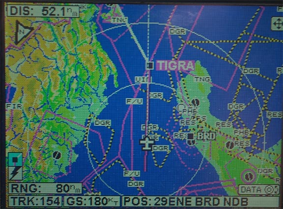
I could not get the shortcut RODON-TIGRA - Brindisi Radar advised that this is in Montenegro airspace and Montenegro don't co-operate; a flight plan needs to be filed on the required route, but I could not get one through CFMU. So we got a series of shortcuts from NERRA to TIGRA instead, remaining in Italian airspace, and the overall effect was about the same but with a long time over water. There was some vertical development around Brindisi so while we were asked to fly via BRD I asked for a left heading change which took us very conveniently towards TIGRA...
Flying over the Greek mainland we did not see any sign of the fires, which appeared to have been extinguished by then.
With a 20kt tailwind, Crete soon appeared on the horizon and despite the haze was visible from about 80nm away. We were cleared for a STAR and a procedural VOR approach, with some curious terminology e.g. "report when ready to commence the approach" which turned out to mean the same thing as "report beacon outbound". The airport has three massive runways and it was apparent (from the amount of rubber on the tarmac) that we were supposed to land on the middle one
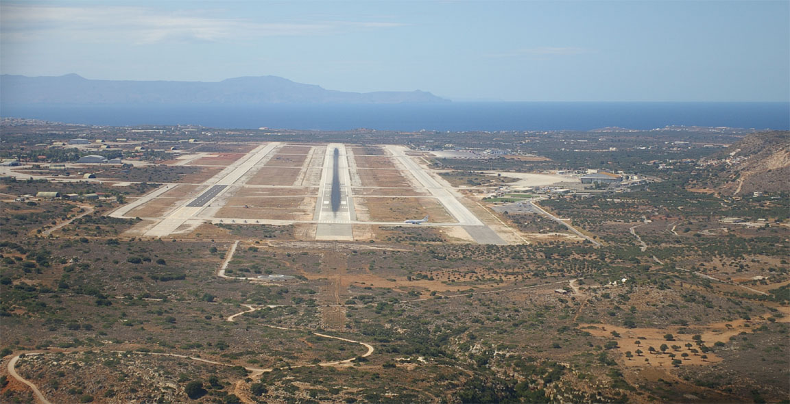
There was a lot of military activity and as we were taxiing, four F16s (which were sitting to the left of the touchdown point) took off and the whole aircraft shook with the noise as they passed by.
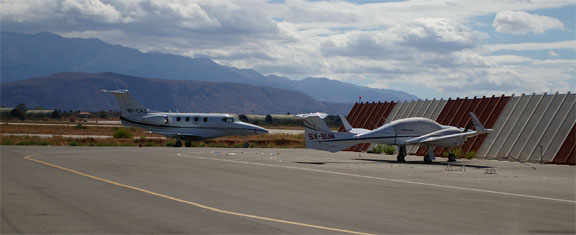
There was some funny confusion as to where to park. The first FOLLOW ME vehicle got confused (taking us to the passenger terminal) and a second one, driven by a much more authoritative figure waving his arms out of the window, took over and escorted us to a secluded GA parking area where several GA aircraft, as well as a nice Premier 1 jet, were parked. We met up with a couple of Greek friends who arrived in a DA42; being a Greek registered aircraft they were exempt from the PPR requirement on weekends.
Avgas turned up immediately (price Euro 2.20 per litre; more than double that of Losinj) and the formalities were completed within minutes, with a very helpful HCAA (Greek CAA) man taking us through and leaving us his contact details for when we depart.
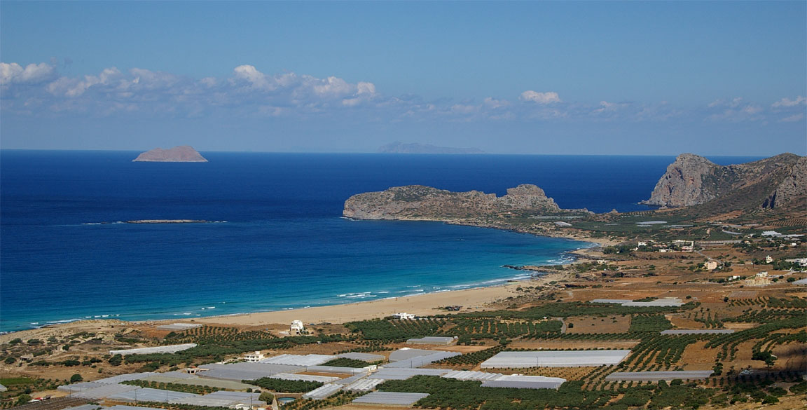
Crete is a very mountanious island
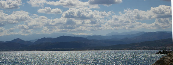
with many beautiful views all around
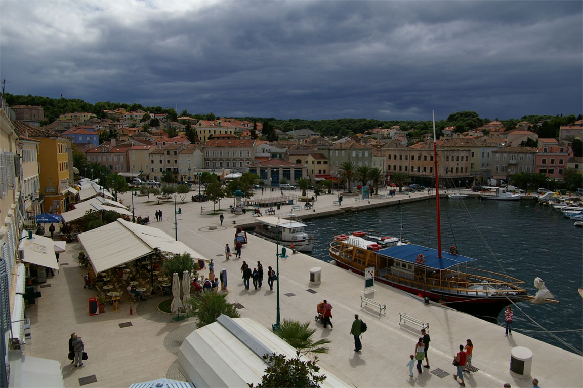
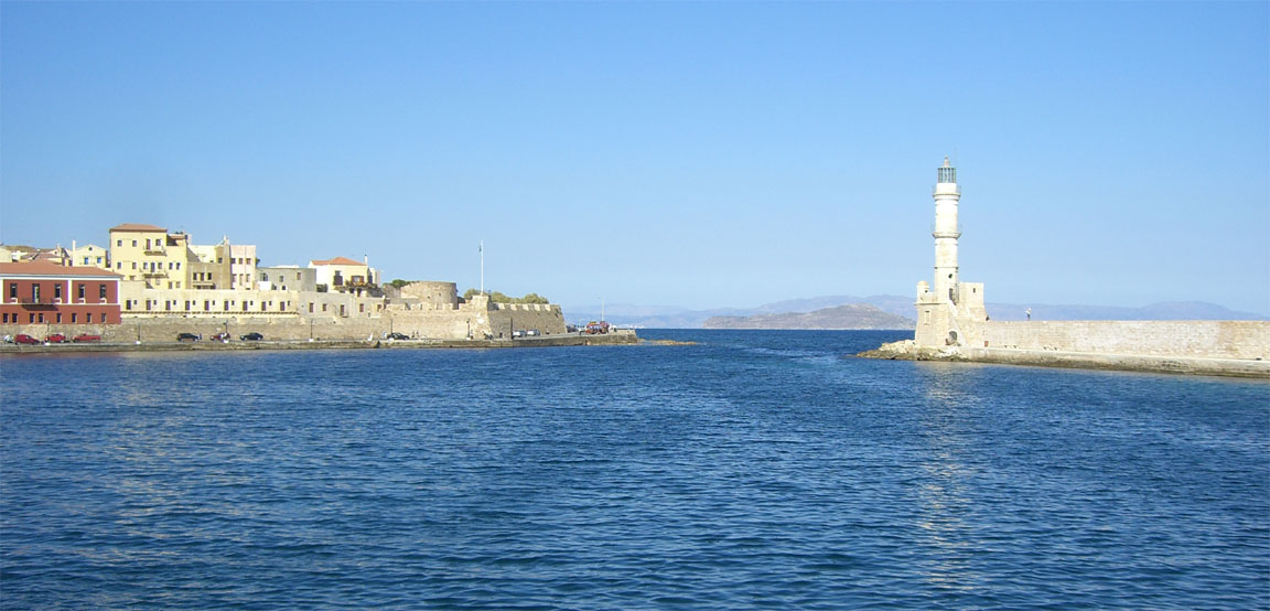
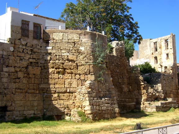
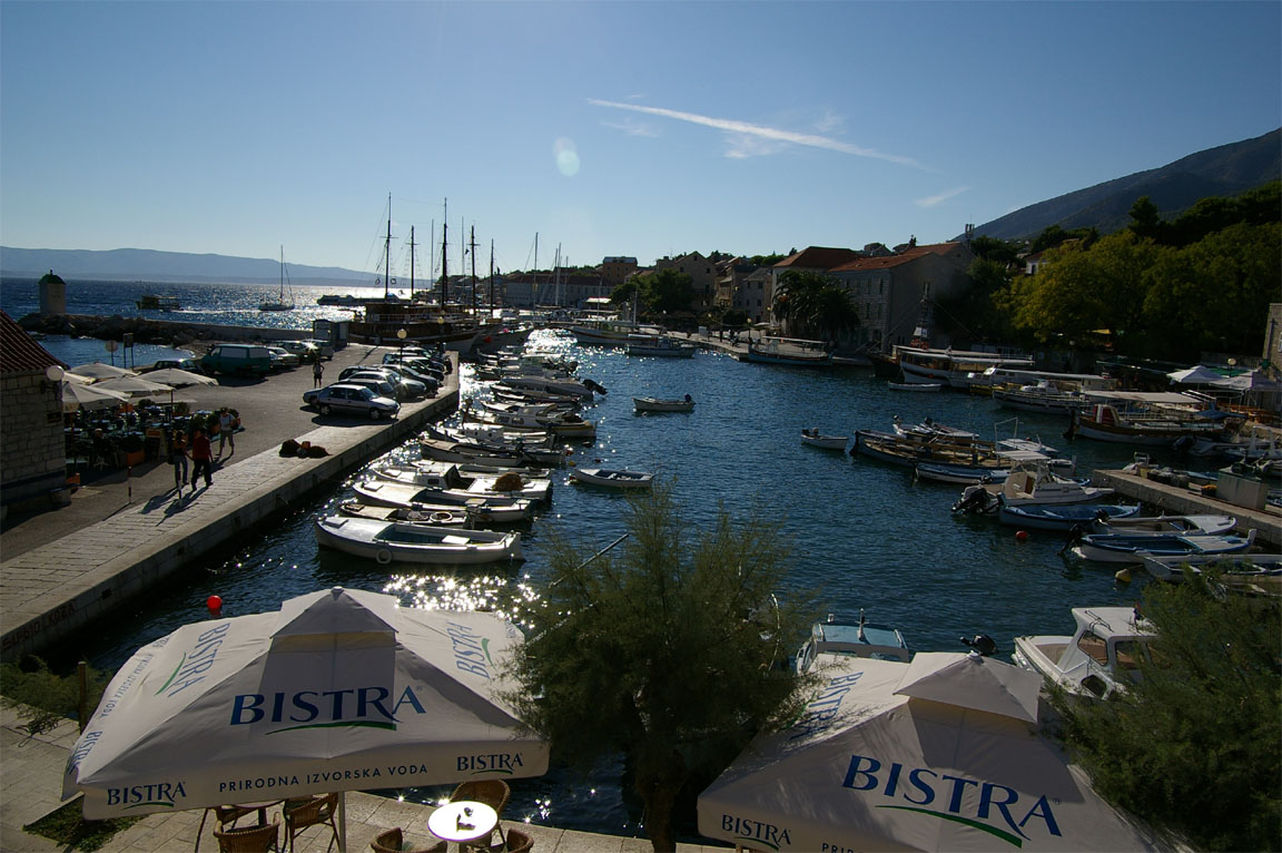
Hania is an historic town, with some intense tourism in the summer. It has a wonderful Venetian harbour
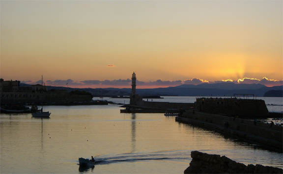
with great sunsets
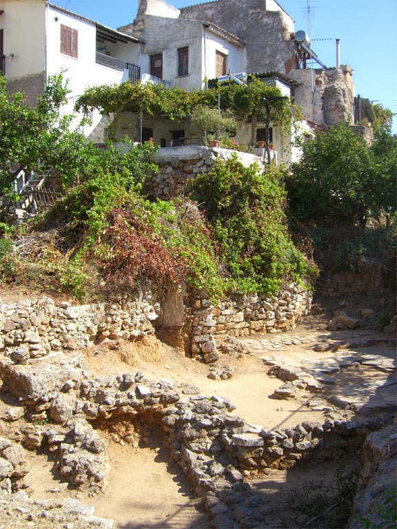
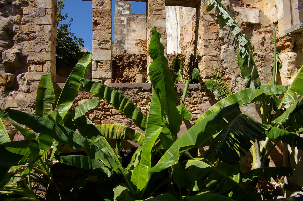
Hania has a history combining Jewish, Orthodox and Moorish cultures. There is a lot of prehistoric (mainly Minoan) archeological sites which have been dug up to varying degrees
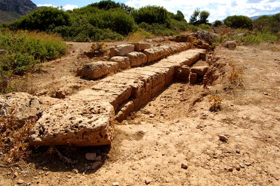
with many within the city and in some cases underneath modern buildings. The inhabitants of Hania are living on top of thousands of years of history
It isn't entirely clear why these sites were left for (apparently) decades after being dug up, fenced off but in the open. Perhaps exposing a site enables the public to view it, prevents building on it, and they are hoping to discover something amazing in which case they could apply for EU money to move Hania to somewhere else in Crete?
Many houses were built within the old ruins - a practice which would be sure to give a British planning officer an immediate heart attack :)
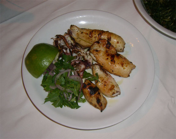
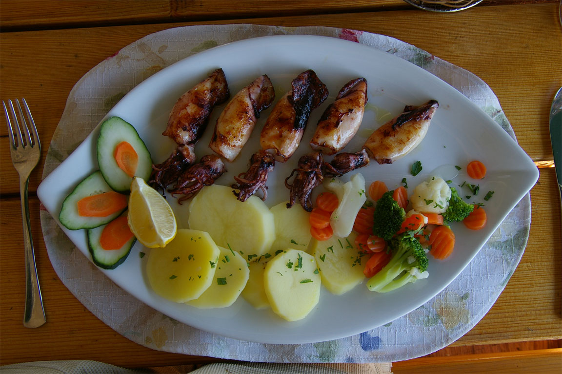
The Greek food is wonderful as always, and the most healthy there is, with seafood being predominant
There are lifeforms in the water which might make you think twice about going for a dip; this one was about 25cm in diameter and seemed to be swimming around the harbour, randomly in the manner of a pilot practicing traditional CAA-approved VFR navigation

Finding accommodation was not completely trivial as hotels were relatively booked up but there was no shortage of "rooms for rent" and we stayed in a lovely self catering apartment near the old harbour, for about Euro 40 per night. This was about 1/5 of the prices being demanded at Santorini in 2005 which was the only other locations where we had to look around for a place to stay. Mid-September is not the main tourist season which clearly helps. Unfortunately all the beds in Crete seem to come from the same factory which makes the mattresses out of cardboard and it was difficult to get much sleep :) It's probably worth paying the extra to stay in a decent hotel especially if one is going to fly the following day.
Despite the tourist invasion, the Greeks are wonderfully friendly people and we found them universally helpful. Most people seen around are actually Greek locals or Greek tourists, with some Germans etc and a very small number of Brits.
Hania is a fascinating juxtaposition of lush green vegetation and ancient ruins, with Greeks living there as if they have been there for thousands of years and nobody thought about fixing up any of the crumbling masonry
There were some problems with internet connectivity, with Vodafone not working (for GPRS/3G) in some places but luckily I had some other SIM cards and Virgin worked most of the time. There was a good number of internet cafes though. As on previous trips abroad, I got caught with the "Vodafone scam" whereby the SIM card balance ran down (to about £6) and when I went to log into their website to top up the account (using a pre-registered credit card) the amount of data which their stupid rubbish-loaded website uses exhausted this and I got cut off halfway through and had to spend another £10 on my Virgin SIM card to put another £50 (the max permitted) on the Vodafone account. Charging customers around £10 (US$20) to top up their mobile account is an obscene practice and I wish one could draw wide attention to it and get it stopped; a website page designed specifically for topping up should be about 10k and not 2MB. One needs to make maximum use of internet cafes, carry multiple SIM cards, or use a contract SIM card funded by one's employer :)
My attempts at refilling the nearly-empty oxygen bottle were finally successful. A contact back in the UK, with scuba diving background, emailed me some dive shop contacts but all were much too far away, with the nearest in Iraklion. And even that one would not fill the bottle, but he gave me the name of a Hania scuba business, which could not fill it either but an employee in the office had an uncle who worked in a hospital, and a phone call to him got us the details of where they obtained their gases from; a visit to their office in Hania led to a referral to the main factory (Mobiak a.e.) near the airport.... Initially, they wanted a week or two to do it, then 2 days, but eventually agreed to do it if we come around right away. It was a huge plant manufacturing various gases for industrial, medical and aviation use. They did not have the right fittings but together with the 540-UK adapter which I brought with me they managed to screw together several things and filled it up from a huge bottle containing what looked like medical oxygen. The charge was a miniscule Euro 17 and one of their employees even drove us back into town. The whole thing took about 3 hours and gave us enough oxygen to complete the planned trip even at FL180. The waste of a whole day chasing around taught me a lesson for the future, regarding oxygen: carry the worst-case requirement with you, from home. Edit 2010: On long trips I carry two $600 "48 cu. ft." composite cylinders from Mountain High and this ended all oxygen issues.
The weather on the planned day of departure looked rather suspect for a nice flight over Istanbul and the Black Sea coast, while the following days looked good, so we postponed the departure initially by one day. I telephoned the helpful HCAA man at the airport who said a delay of 1 or 2 days is no problem at all. I had earlier faxed the HCAA itself with a PPR request for the departure and they phoned me back with some fussy questions but in the end seemed to be OK, and the faxed permission (covering two consecutive days) arrived the following day.
A Big Re-Plan
When I filed the flight plan to Constanta the evening before departure, via Homebriefing as usual, disaster struck. The airways route, which validated fine with CFMU immediately before our departure from the UK about a week previously, was rejected, for any level below FL245.
G123 NOT AVAILABLE ON PORTION MAKOL REVDA IN FL RANGE F045..F245
I tried some route replanning. First I went back to the usual route planning facilities but the only CFMU acceptable route was a completely silly one which went hundreds of miles to the north west before coming back down and which would have nearly exceeded the aircraft endurance...
Next I tried a tactic which many pilots claim to use successfully: file the flight plan with a "reroute accepted" remark which enables Eurocontrol to correct the route, but this failed too, twice in succession.
I then tried to phone Homebriefing, and after spending an estimated £50 listening to the music on their telephone queue (they appeared to have just the one man on duty) I got through but he said there is nothing he can do because if Eurocontrol won't correct it, that's it. I explained to him that this route worked just days ago and is likely to ruin our holiday but nothing could be done. He suggested that I file the "silly route" which was far too long but worked, and hope that ATC will let me shorten it when airborne; I refused to do this because (a) it was so different from reality and (b) this is a part of the world where somebody could get quite aggressive.
One remaining option was to file the flight plan under VFR. The problem here was a lack of VFR charts. The only available charts are the US military ONC/TPC charts which have not been updated for around 10 years. I had these in electronic format on a laptop and as a moving map GPS, and had some printouts, but not really enough for the job if ATC had decided to throw some "well known local waypoints" at us. Also, there was a reasonable chance of low cloud at Constanta, making a VFR arrival questionable. In retrospect, this would almost certainly not have worked either because the problem was military activity in the area.
So, with us trapped by the PPR window for the departure from Hania, the weather situation, the seemingly intractable Eurocontrol routing problem, and not really enough days left to play around, I decided to give up on the remainder of the holiday which had already been stressful enough, and replanned a return flight back to Losinj, with a view of going back to the UK from there, or perhaps on to Prague, either of which would have been a direct flight. Losinj is a good stopover point because of its very cheap fuel, and it's a nice place to stay anyway.
However, when I went to check my email to make sure the Losinj flight plan had not been rejected later, I found (from a sequence of automated emails from Homebriefing) that the good man there had cancelled it and had been trying other routings for our original destination, Constanta. I also telephoned him. He found it worked with a 0100Z departure but could not make it work for 0700Z and after a couple of hours he gave up and re-filed my flight plan to Losinj.
Update: After returning to the UK, the mystery was resolved. The airway G123 had been closed by some military activity, which appeared in the notam data I had at the time (see the bit in bold) but I didn't spot it among the mass of rubbish comprising mostly of Greek versus Turkish airspace disputes. I also discovered a couple of Eurocontrol phone numbers for routing help desks which might have helped had I known about them at the time; these are now in my mobile phone. In fact it was lucky that I had the notam data recorded at all, since my normal procedure is to first work out a route acceptable to Eurocontrol and only then check for notams along that route. Subsequent correspondence with Eurocontrol suggests that they sometimes err on the safe side and reject a flight plan altogether because they receive complains from operators about the re-routed routes...
As a result, a number of planned routes were not flown.
Hania (Greece) to Losinj (Croatia) - diversion to Brac (Croatia)
LGSA SOKRI J65 TRL L612 ARA A14 KRK L53 OKIMO A48 CRAYE B9 SPL L607 ZDA N606
EBITA LDLO
Lowest valid route level FL130
Distance: 702nm GC, 717nm airways
Flight time: 4:40 hours
For a change from trying to get to Constanta/Odessa, the weather looked good, for a 0700Z departure: TAFs MSLP 0600 1200 SigWx 0600 1200.
Due to a combination of factors (having to move rooms due to the 1 day delay; a hard bed; a useless pillow stuffed with cotton; mad dogs barking outside; mosquitoes in the room; a noisy fridge; the last-minute hassle) I did not get any sleep but felt OK and anyway this has happened before, so off we went back to the airport...
The departure was delayed by a lot of F16s taking off and flying what looked like circuits - basically nobody would talk to us on the radio for about 10 mins. Then we got a departure clearance for a visual departure with a DCT MIL and a climb to 5000ft. We were quickly cleared for takeoff and off we went. The controller appeared to not have radar (hard to believe, on a military base) because he was giving us a stepped climb and was asking for DME distances. Gradually we got a climb to FL100 where we stayed for a bit, later climbing to FL110, 120 and 130 to get above some clouds.
As previously, the SigWx cloud top data was largely fiction, with plenty of cloud cover starting from just after Hania to the end of Greek territory, going up to FL120. But there was nothing of relevance and the flight was completely smooth and uneventful. By the time we reached Corfu the cloud had largely disappeared; this is the town and the airport
I had reckoned on a significant headwind - this was apparent from the MSLP charts. However, once we reached top of climb, the fuel flowmeter was indicating that we would have about 20USG FOB (fuel on board) at the destination. This did gradually improve but - while plenty legal enough for FAA IFR reserves of destination, alternate and 45 mins at cruise speed - it wasn't to my liking and I decided to stop somewhere sooner.
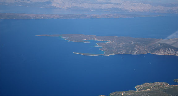
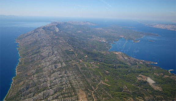
Like most of the former "Iron Curtain" countries, Croatia is general aviation friendly (if nothing else, they have reached the obvious conclusion that effectively closing an airport to light aircraft for the sake of several cheap-airline 737s per day is a stupid way to do business) and offers a number of options, starting with Dubrovnik at the southern end. I played around with various destinations starting with Split, entering each into the GPS and seeing the recalculated FOB value. Split was a good choice with 33USG FOB but, looking at Jeppview airport data, the island of Brac which is close to Split was found to have Customs and Avgas and looked a more interesting place to stay. This was a holiday, after all! The location of Brac is very close to the SPL waypoint in the above route picture.
Within Greece, there was little point in asking the mainly military controllers to amend the flight plan since the communications indicated they had no access to our flight plan, so I initially asked Kerkira (Corfu, LGKR). They questioned me as to the reason; I replied that we were below reserves (not strictly true) at the planned destination due to stronger than expected headwind, which they appeared to accept. They helpfully gave us a few shortcuts and appeared to coordinate with the next region, Brindisi, who gave us a very direct route towards Brac, smoothing out the OKIMO/CRAYE kink in the above route. I noticed the route given did very exactly "just avoid" the Montenegro airspace - presumably Montenegro don't co-operate as described previously.
Next was Dubrovnik Radar who cleared us to the SPL (Split) VOR which indicated that they knew nothing about the change of destination to Brac... this turned out to be correct; Kerkira had evidently not amended the destination on the Eurocontrol routing. However Dubrovnik were completely unconcerned and immediately gave it to us without any question or comment. Interestingly, we never talked to Split, despite landing right next door to their airport.
Brac is one of many lovely islands along the Croatian coast
This one is Hvar which immediately preceeded Brac on the inbound route. The Hvar runway is just about visible in the pic, if you know where it is. It appears to be a dirt strip. From the radio, there was a Pilatus (presumably a PC-12) inbound there.
Dubrovnik clared us for a visual approach to Brac runway 04; the 04 end is on the right in the following pic
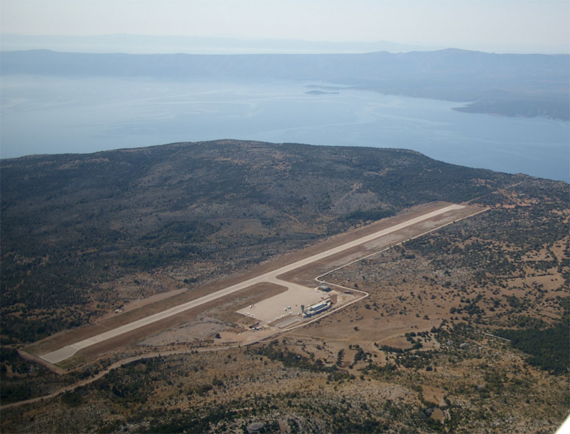
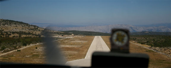
Brac tower warned of "wind shear" which terrified Justine who had only once heard this before (37kt reported by an Airbus on a final into Dubrovnik in 2006, in real CB-induced conditions, and we aborted that approach) so I was expecting some excitement, but in reality there was just a bit of interesting turbulence due to the approach over the cliff; the approach is over the sea but the runway is at 1700ft. The landing was easy. It's a big runway; about 1400m.
Brac must be the best airport I have ever been to.
The entire place seems brand new and everything is perfectly organised, with very helpful and pleasant staff and zero hassle. We followed a FOLLOW ME vehicle to the avgas pump, and then several men pushed the aircraft to a corner of the apron which as you can see was sufficiently crowded to justify a 5-day PPR requirement in Greece, to enable them to "manage apron capacity" - the actual words of the Corfu airport manager whose apron was similarly full and about 5x bigger.
Avgas was very slightly more expensive than at Losinj but still a lot cheaper than elsewhere. Evidently, the airport is keen to get more visitors (they get a lot from Germany and Austria at weekends, apparently) and already has 750 movements a year most of which are in the summer. Brac is an ideal destination for anything including a light jet.
I have a very accurate fuel flowmeter which I check at every fill-up. Normally the error is within a -1% to +1% band but on the fill-up at Brac it was -5%. We did lose some fuel from the tank when parked at Hania (a drop in level of about 20mm) due to thermal expansion in the heat but taking the thermal expansion of avgas together with the largest plausible temperature difference between their bowser and the wing temperature, a 5% error is around twice of what I would have expected. Curious!
The airport offered a taxi to the main town on the island, Bol. The road was quite exciting, winding down a long cliff through many tight bends.
The town of Bol is a very pretty place which appears to have been built (or heavily repaired/restored) in recent years. It has a lovely harbour with lots of boats
We went off to get some excellent food
It was clear that with just a few days remaining of our holiday we would spend the rest of it here, rather than trying to get to god forsaken places which need a year's notice for telling you whether they even have avgas....
Most tourists in Bol are locals (Croatian) with a fair number of Germans. There is a lot of self catering accomodation and one could certainly live there cheaply, with prices being about 1/3 of the UK. We stayed in the only hotel in the town, Kastil, which was excellent in every way and cost a fraction of what we had expected to pay.
We did a one-day trip to the next island, Hvar. The town is also called Hvar and is larger than Bol, and is a much more upmarket destination, with several 7-figure-priced Cannes-type boats in the very attractive 16th century harbour. It's also a lot older than Bol and resembles a smaller version of Dubrovnik. There is an apparent Venetian influence in the architecture. There are countless craft shops and jewellers. The fort above the town goes back about 3000 years and offers great views of the town and the harbour.
Without a single exception, every Croatian we had met was very nice and many were extremely helpful. There appears to be little work on these islands outside of the tourist season which ends at the end of October. However the weather there generally remains good through to mid-November.
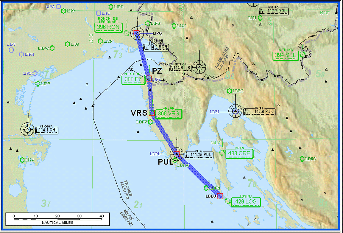
Brac (Croatia) to Shoreham (UK)
It was tempting to go back home via Prague - a great central European city where I was born and which is always nice to visit. Had the weather at the relevant latitude been OK we would have gone to Prague straight from Brac, and Justine would have gone home on a commercial flight if necessary, but the weather was a conveyor belt of fronts and troughs and we had run of time... We had to get back within a small date window, due to worsening UK weather and the need to be back home to supervise a house building project.
The weather back to the UK appeared to have a 1-day window, but the nonstop airways route was rather long, at slightly over 900nm and there would be some headwind. Therefore I decided to fly via Friedrichshafen EDNY as a fuel stop. Having the stop after the Alps is better since the crossing is done at the earliest possible time in the day when the weather is likely to be better.
Neither the ASA website nor Flitestar was able to generate a CFMU acceptable routing for LDSB-EDNY (with some even more than usually meaningless errors emanating from CFMU) but I was able to hack the one from Flitestar and finally it was accepted. The problem was early on, in Croatian airspace, and normally Croatia is not difficult and most "obvious" routes do work.
I already had a route EDNY-EGKA worked out from a visit a few months back, but (no suprise) it no longer worked and had to be hacked around near the EGKA end.
On the night before the flight, the long TAF for Zurich (the nearest airport to Friedrichshafen that has long TAFs published) was indicating fog till 1200Z, which forced a replan with a different stop point. This time I chose another airport that I have been to before and knew it to be efficient; Padova LIPU. Justine went off to get some A4 paper so I could print out the approach plates for the destination and alternate..... all over again...!! I could have chosen Trieste but their "avgas facility" was extremely primitive last time we used it (2005) and could have been a long wait.
Then, when getting the notams, it was discovered that Shoreham airport was closed till 1700Z due to the annual air show... with its closing time of 1900Z this left a 2 hour window which we had to hit. I should have remembered this!!
Route: LDSB SPL L607 ZDA N606 PUL P11 ROTAR M167 CHI LIPU Alternate: Trieste
LIPQ
Lowest valid route level FL090
Distance: 242nm GC, 257nm airways
Flight time: 1:40 hours

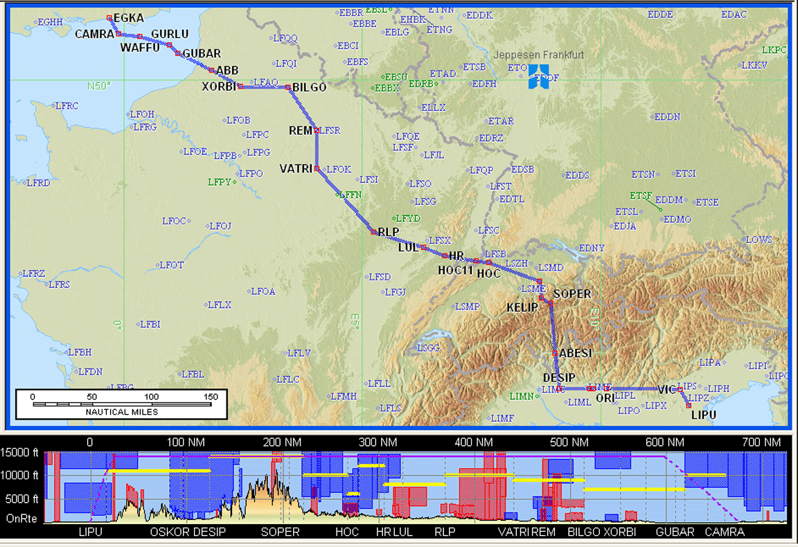
Route: LIPU DCT VIC B4 DESIP N851 SOPER Z51 KELIP Z651 MANEG L613 HOC G4 RLP
B3 BILGO H20 XORBI G40 ABB T27 GURLU Y8 CAMRA DCT EGKA Alternate: Bournemouth
EGHH
Lowest valid route level FL130
Distance: 584nm GC, 675nm airways
Flight time: 4:30 hours
The weather was good: TAFs SigWx 1200 1800 Winds.
The flight plans were filed the night before and were accepted. On the morning of the flight I was unable to get Padova ATC/Ops to answer the phone, on a number which worked the previous day, which based on my past experience of Italian airports I should have regarded as highly suspicious, but off we went anyway.
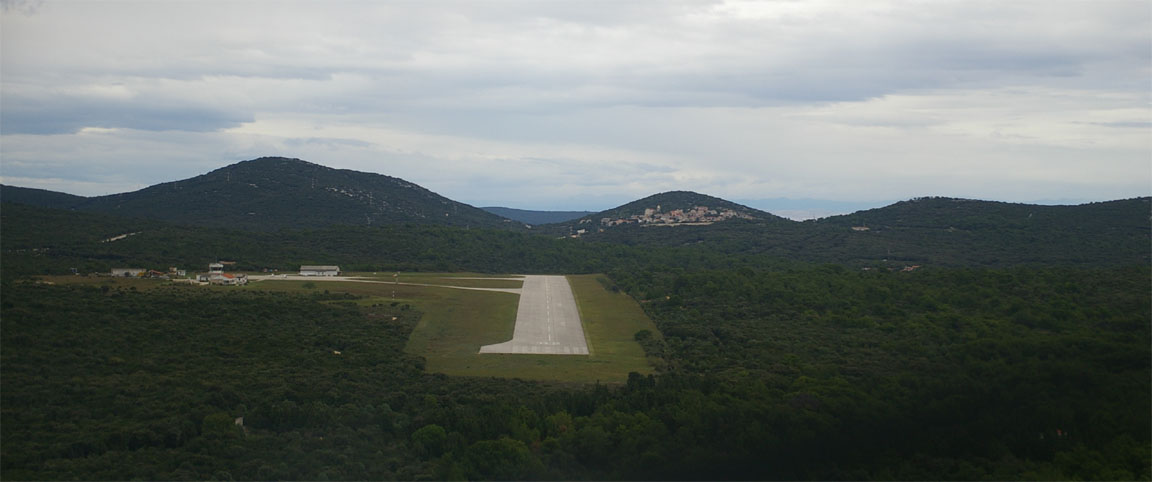
This time, Sunday, Brac airport was rather more full, with about a dozen light aircraft. This was good to see because they are such nice people there and they deserve the visitors. The departure from Brac was on a SID but we quickly got a radar service from Split and then Pula. Croatian controllers were efficient as ever and very pleasant. The ATCO at Brac was particularly good - it is rare to find ATCOs "down south" who use the correct non-ambiguous terminology.
The flight was uneventful, at FL100, in a lot of haze but with plenty of views of the Croatian islands and coastline, until Venice Radar (whose radio was dreadful, badly distorted, with poor English, and not listening to readbacks) was about to hand us over to Padova Tower, when they said Padova is refusing to allow us to land because we have not given them a prior notice for Customs. This was bizzare since in general one does not need to leave airside when refuelling so there is no need for Customs. The notams for Padova did not say anything about this either, and we have been there before. I also happen to know, from 2006, that the office where one pays is more or less just a room with a door to the airside. Also, by this time Padova would have had both our flight plans, inbound and outbound with just 2 hours apart, indicating clearly that we were not stopping there. I think they were just being bloody-minded. While I was going around the hold on the Padova NDB approach, Venice asked about our "intentions"; I replied that we just need to refuel with avgas, somewhere.... They went off and consulted, and came back recommending Venice or Treviso. I chose Treviso since Venice (Tessera) would likely take a while, being a large and busy airport. I did not have the Treviso plates printed of course but the LS800 tablet with Jeppview was just fine. We asked for and got a radar vectored ILS to Treviso
While still on final I was asked whether I needed fuel and I confirmed this with "avgas". Upon landing, we discovered from the GA office that there is no avgas.... Actually, there is an aeroclub but they keep avgas to themselves, not for any visitors. And the aeroclub office was empty anyway. Welcome to Italy!
It was disgusting of Padova (whose GA office could easily accept payments without leaving airside) to refuse the landing, and equally disgusting of Treviso (whose Tower clearly didn't give a flying f**k whether their own airport actually had avgas - a level of ignorance described by someone working there as "well known") to allow us to land, extracting another Euro 45 from us and wasting an hour.
It was suggested at Treviso that we clear Customs at Treviso and fly back to Padova for the avgas, but I realised this would be no good either because Padova would then refuse the departure to a foreign country; the man at Treviso confirmed this was what would have happened. So, we had to get out of Treviso fast, and with no fuel taken.
The bigger problem was that I had to replan the Eurocontrol routes (for Friedrichshafen, again) and file the flight plans, in double quick time, which I did with the laptop using 3G while sitting in the Treviso passenger lounge.
Luckily we had plenty of fuel to fly to Friedrichshafen, despite the two wasted refuelling attempts. We didn't have the enroute charts and the plogs etc printed out, but I managed to write down the waypoints, enough to be able to load the GPS, and the LS800 tablet with Jeppview would have provided the rest...
Route: LIPH CHI Z906 BZO M726 KOGOL L608 KPT EDNY
Lowest valid route level FL150
Distance: 164nm GC, 274nm airways
Flight time: 2:00 hours
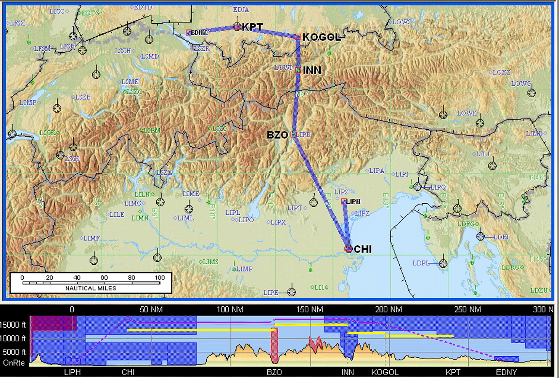
The CHI5F SID took us back south to CHI and we asked for a DCT in the desired direction to BZO, which we got, but the radar controller was concerned that we were VMC because initially we were below his radar vectoring altitude. We were about 5000ft above the actual terrain though, and in clear VMC. The CHI SID goes south to give aircraft enough time to climb for terrain clearance, before turning north.
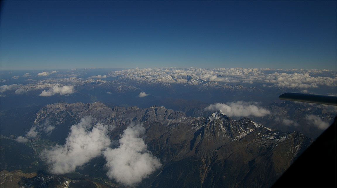
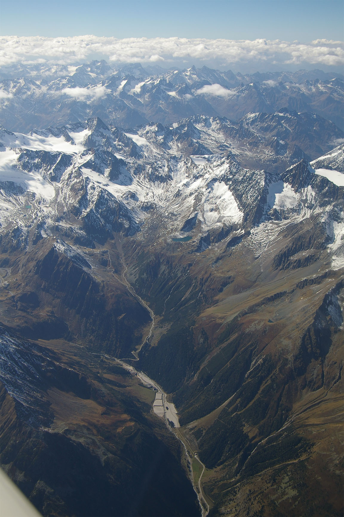
For the first time in a few crossings, the cloud cover wasn't too bad and the flight across the Alps provided some great views
We got a radar vectored ILS from Munich Radar, who asked us to maintain max speed as we were "number one before a 737". This was easy to do as we were descending continuously from FL160 to about 3000ft; the entire descent was at about 170kt IAS. As with Italy earlier in the day, it was hazy everywhere...
Friedrichshafen were super efficient and refuelled us with a bowser within minutes. Unfortunately, paying for the stuff required a bus to Customs and the payment office, and while Justine went to do that while I got the laptop out to work out the routing to Shoreham and file the flight plan (sitting on the floor outside the Customs door) she had problems getting back out because she was not a "pilot". Eventually we met up airside but by then we had both torn all our hair out and were well sick of the whole business.
Route: EDNY TRA L856 HOC W102 LEPLA W110 LUMEL T10 TORPA V40 LUL G4 RLP B3
BILGO H20 XORBI G40 ABB T27 GURLU Y8 WAFFU EGKA Alternate: Bournemouth EGHH
Lowest valid route level FL150
Distance: 428nm GC, 488nm airways
Flight time: 3:30 hours
Then, just to make the point to us that this was not going to be easy, we got a slot from Eurocontrol (sent by Homebriefing by SMS) delaying the departure by 19 minutes. These slots are invariably a joke, since there is practically no traffic at GA levels anywhere in Europe. However, Friedrichshafen tower were nice in allowing us to take off at precisely the earliest possible moment.
Homebriefing confirms flight plan acceptance/rejection, and any slot allocations, with SMS and/or email. Since I started using them in 2003, the SMS messages were found to nearly always arrive after the flight was completed! This is obviously no good for slots. There seems to be a delay of a number of hours. The emails however arrive immediately, so if "on the move" one needs to either telephone them, or have a mobile means of checking emails.
Initially, the ETA on the KLN94 was showing we would not make Shoreham's closing time by about 20 mins, but gradually this was improved by a combination of lowering the cruise level to FL100 which was maintained all the way home, begging for every shortcut imaginable (everybody but the French were really great, although Lille gave us a nice shortcut in the end) and operating the engine slightly rich of peak which wastes fuel but does deliver a little bit more power.
Nearly home, at FL100 and just before starting the descent into the muck hanging over the UK, we saw a great sunset

London Control had given us an early "descent out of controlled airspace". Clearly they must have purchased some new microphones because the man was the clearest speaking ATCO (for a male, anyway) I have heard for a long time. The weather at Shoreham was as bad as forecast; OVC009, cold, with light rain, with some fun wind shear on short final, and the place was quiet as a graveyard, but hey you don't expect to come back to the UK and to good weather!! The very nice ATCO sounded pleased to hear from us - from the flight plan enroute time it didn't look like we would get there. We landed 15 minutes before the airport closed.
The day's flights, with a total of 3 landings, were probably the most stressful flying I have ever done, although obviously this does not include the ludicrous pressure one is under when doing IR training.
Such a lot of hassle which would have been avoided if we flew from Brac direct to Shoreham... In retrospect, the flight could have been done with legal IFR reserves, but over the English Channel is not the place to be looking at the fuel flowmeter. The decision to refuel was therefore correct, but if it was not for the bogus fog forecast for the Friedrichshafen area we would not have wasted time in Italy. One could have played this more cleverly but this is difficult under IFR because one has to file a flight plan with a valid airways route, and fog may be localised or it may be widespread.
Overall, the routes actually flown were:
Observations and Lessons Learnt
All airborne time on this trip was uneventful other than the hassles in Italy.
After leaving the UK, only one or two GA aircraft were seen while airborne on the entire trip. We did see a few jet transports at sub-FL200 airway levels but they were many miles away - so much for "crowded European airspace".
This trip turned out to be exceptionally difficult at times, not in the flying (which was easy and highly enjoyable) but in the other rubbish that one had to deal with.
The main observation is how easily Eurocontrol/CFMU, in combination with schedule requirements (e.g. airport PPR dates), can totally trash one's plans by not providing re-routing assistance. The inability of Homebriefing to correct a route; effectively a confirmation that they do not have a facility via Eurocontrol for doing this, is revealing and conflicts with what many pilots believe the "system" is capable of. There is a valid argument that Homebriefing should have been aware of the notam and should have provided assistance to a pilot who telephones them... One smart thing would be to do a text search of the notams for the name of the airway which is being rejected but probably the best thing would be to simply telephone Eurocontrol. The numbers for the IFP1 and IFP2 help desks are: 0032 2 745 1950 and 0033 16 988 1750. Another smart move would be to check a day before the flight whether CFMU accepts the route, rather than a week or two before and hope it will still be OK on the night, which is what I did. This situation is unlikely to improve since the major airspace users (airlines) have planning departments which do this crap for a living.
The next one, well known anyway to most IFR pilots, is that weather forecasts - cloud tops especially - are so often just fiction. TAFs are normally OK but they are of little use for higher levels except in their ability to indicate a probability of CBs. The cloud tops forecasts (from SigWx, Meteoblue) are mostly a joke. The MSLP charts are OK in their depiction of big powerful frontal systems but when it comes to indicating weaker fronts, or troughs, it seems that a forecaster could draw the lines more or less anywhere. They also do not indicate (except to an expert, perhaps) weather that happens in the absence of fronts. It is likely that the reason nobody is too bothered about this since the SigWx data is used mostly by jet pilots who don't care whether tops are at FL150 or FL200 because they are climbing to FL350 anyway. However, I have not yet encountered (the first flight on this trip came close) a discrepancy between forecast and reality which was bad enough to take matters outside the TB20 aircraft performance.
I think an ability to get weather while airborne can be very useful, for planning of alternates. One can get weather from ATC but often they won't do it for an airport in another country. Unfortunately, in Europe there is really only one option: a satellite phone, and it doesn't come cheap especially considering how sporadic the usage would be. They can be rented though. One would use it for normal internet access, which is available at 38k baud; about the speed of a slow old analog modem. The main requirement would be for METARs (actual airport weather) which involve very little data.
The oxygen issue is a real one on long trips like this. We carried two "13 cubic ft" bottles but clearly more was needed. It is time to either get a much bigger bottle (of composite construction, otherwise it would be too heavy) or get the Mountain High electronic demand regulator which reportedly works better then the Nelson / Precise Flow mechanical one.
The "technology" we carried was perfect for the job. The lightweight laptop+printer combination turned out to be ideal for any last-minute flight re-planning, and was used to write up this trip report, a little piece at a time, as we went. The multiple backups employed to ensure one could get weather, file flight plans, etc, turned out to be exactly right. I just wish there was a cheaper way to get mobile data than the ripoff tarriffs of Vodafone and other mobile networks.
The "Italian experience" is really in two parts. According to its AIP entry, Padova requires a 3 hour prior notice for Customs, which I imagine needs to be by telephone (which they didn't answer, on the morning of the flight and during their opening hours which were verified the day before with a phone call to the same number...), or by fax (which then involves an unspecified wait for a reply, and constant checking for a faxed reply on my fax2email service). However I still don't see why an aircraft needs a Customs clearance to refuel. The lack of avgas at Treviso was just a cockup by area ATC which was compounded by the attitude of the Treviso tower. The lesson here is to not fly to an Italian airport again unless the availability of fuel etc has been verified with a phone call, or they have responded to a fax. It's a pity that I got caught in this way, despite being so careful in contacting all airports beforehand at all other times. However, Italy has proved to be a total joke on our previous trips too and if something is going to go wrong it will. One might expect this sort of thing in Egypt but not in Italy. Neither Padova nor Treviso responded to my emailed and faxed requests for an explanation.
The main reason this trip was stressful is that we attempted too many stops in difficult locations, relative to the two-week time frame. I should have realised that foreseeable issues like Hania's 5-day PPR were bound to screw us against the weather or anything else that happened to come up. Also, the smaller airports in Italy are best avoided for ground stops that require fuel or Customs - unless you have a sure way of checking out the destination; the best method being an Italian speaker who telephones them shortly beforehand. H24 (open 24hrs/day) airports rarely cause these kinds of problems.
Justine and I have decided to use the aircraft rather more for single-leg (i.e. up to 800nm away) getaways which involve much less weather risk, and with the TB20 one can do many such trips without even refuelling away from base. The zero-fuel range is from Shoreham to Corfu - around 1200nm - this is exceptional and is significantly bettered only by vastly more expensive turboprops or jets.
This trip, has it been flown as planned all the way to Ukraine, would have taken us close to the limit of what can be done without employing a specialised overflight permit agent.
The aircraft performed flawlessly. The TB20 is an excellent comfortable long distance tourer.
Last edited 13th August 2010
Any feedback, reports of dead links, corrections or suggestions much appreciated:
Contact details
