I flew the TB20 from Shoreham (EGKA) to La Axarquia in Spain (LEAX, also known as Velez-Malaga) to stay with some friends who live in the nearby town of Frigiliana.
Outside the UK, this trip was flown under VFR. This was one of my first long flights across Europe.
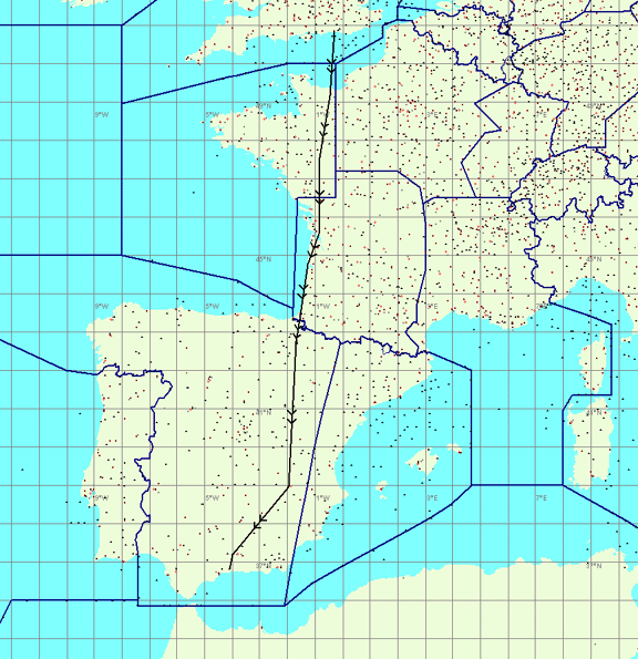
This was the famous long hot summer of 2003. The QNH was 1013 for almost the entire route! On the day the air was very still - less than 5kt wind aloft - and the route looked just feasible in one leg, taking a total of nearly 7 hours. However the reserve would have been far too small to be safe and as I try to never fly with less than 2 hrs' reserve I stopped at Biarritz (LFBZ) for a refuel. The Customs requirements also prohibit a direct flight from the UK to a non-Customs airfield abroad. The map below shows the whole route; Biarritz is about halfway:
Please note the above map, generated as a screen capture from Navbox, is slightly distorted due to the simple rectangular projection used.
A glance at a French aviation chart makes one jump at the mass of restricted/prohibited military airspace. This was not my first trip to France but at that time I was still using the 1:500k IGN charts which while being the clearest available do not show airspace above FL055, and I had not realised that the easiest (if not necessarily the most scenic) way to fly in France is above that level. Doing so avoids much of the military airspace which is most promiment at low levels, say below 3000ft. I have since abandoned the IGN charts for the 1:1M SIA ones, not just to get the higher level information but also because IGN have a little "history" on the accuracy front. SIA charts are the official ones and in France that means everything :)
On this route, the key section was along the long straight western coast which is restricted area R31A1. I had not realised that while the French official publications state that the activity of R31A1 can be established by a VHF radio call to Cazaux, there is a far easier way to do it which is a call to Brest Information when first entering France! They presumably telephone Cazaux. Then one changes one's route if required - with a VFR flight plan nobody particularly cares which route you take to the destination. It's a bit like in the UK - a call to London Info will establish most things.
So one has to plan two routes; the above scenic route (likely to be approved on weekends, R31A1 inactive):
EGKA NEVIL CAN ANG RY TEMP LFBZ (where TEMP is a waypoint on the West coast at the same latitude as LFBD; the track RY-TEMP is about 200 degrees)
and a slightly inland one (for weekdays, R31A1 active):
EGKA NEVIL CAN ANG RY NB BE LFBZ (where the leg RY-NB must be flown at 3300ft QNH minimum due to the Les Blayais TRA)
The above routes are mostly via navaids so one has dual GPS+navaid navigation. NDBs work well over the large flat areas of France and I have found are as accurate as anything else. However French VORs don't usually have the co-located DMEs that we have in the UK so the DME is likely to be useless except to get a distance to somebody's ILS. NEVIL is the FIR boundary between the UK and France.
Due to the planned altitudes (up to FL140 unless clearances were obtained) I carried a portable oxygen kit. There is more information on this and other flight planning issues in the Crete trip writeup. On this trip (3 days total) I did not have any way to get detailed weather or notams while on the move. I would not do that again but in this case it was fine because the notams could be checked in advance, and the weather was very stable and excellent over a large area and showed little sign of changing. Also there was a TV where I was staying.
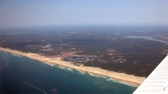
As the outbound flight was on a Sunday morning, I took the scenic route. The last portion runs along the long straight coast of western France. Once R31A1 is inactive there is no lower altitude limit. The following pic was taken about 10 miles north of Biarritz. Deep in that forest is a caravan site where I stayed on my first ever holiday in 1983; though my recollection of that are blurred due to the alcohol consumed... It was all sand and palm trees down there.
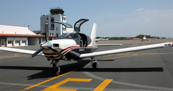
We did a crosswind join for a left hand circuit for runway 27. Biarritz ATC is very good; the most friendly I have seen in France. There is ample GA parking and very little activity.
Fuel is no problem, but leaving the UK early morning means the arrival is likely around mid-day (the flight from Shoreham is just over 3 hours) and the one and only fuel man is likely to be doing the RyanAir or Air France 737! I've had this each time I've been there. So one can get a 30-60 minute wait. Perhaps a request for fuel while still in the air might help.
The toilet and the place to pay the negligible landing fee are at the executive aviation terminal which is to the left of the tower in the above picture, directly behind the centre of the propeller. The GA entrance/exit is also behind there, so one doesn't go anywhere near the passenger terminal. The whole place is very informal and very quick if one wants to pop into the town. Taxis are waiting right outside. If one has passengers, Biarritz is certainly worth an overnight stay. It's a bit like a very upmarket Bognor Regis, with lots of designer shops and some nice beaches.
Biarritz doesn't come with guaranteed good weather. As I found on a previous occassion, it has a tendency to get a 600ft cloudbase which just hangs in there for days at a time.
The rest of the route was over Spain. The route involved some high altitudes due to the terrain and also due to the need to fly above restricted areas. I could have chosen to fly along the Class D airways, at slightly lower levels, but chose to fly outside them in case clearance was not given. The route was
LFBZ PAP VAB GDA LEAX
As Biarritz is so close to the Spanish border I did not use a waypoint on the FIR boundary.
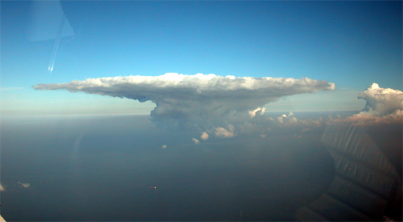
Out of Biarritz, one needs to climb rapidly to clear the mountains. As is usually the case, there were some spectacular clouds south of the Pyrenees which were well avoided; the pic below was taken at about 10000ft and that cloud was at least 30 miles away:
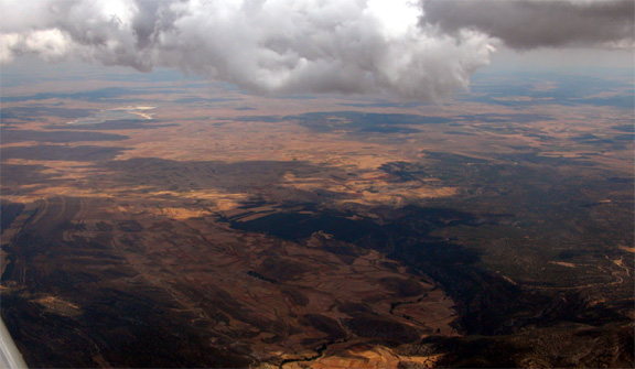
There was however very little turbulence. Much of northern Spain looks dry and barren:
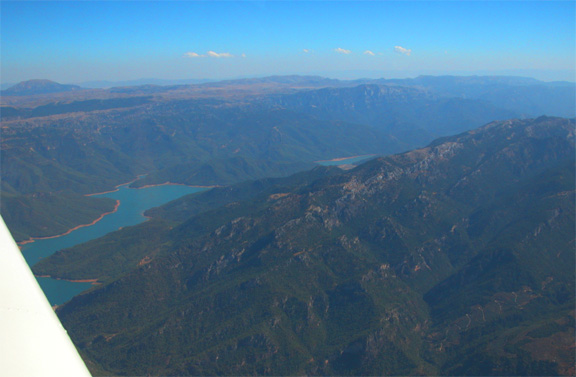
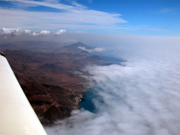
The VAB-GDA leg is very interesting. One flies over very spectacular terrain containing many lakes:
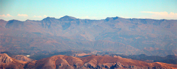
and the Sierra Nevada range is visible to the south; the pic below was taken at about 11000ft which is about the height of the highest peaks:
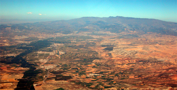
The Granada airport was visible to the south. In the following pic one can see the runway, about 1/3 from the left. I was in radio contact; essential as I was going right through their ILS.
The whole area contains many old forts and would be well worth a visit. The OAT at 11000ft was about +2C and it must have been absolutely baking hot down there on the ground! No other light aircraft were seen or heard all the way through Spain; I heard one executive jet going into Zaragoza, and some Easyjet-type traffic.
ATC were helpful throughout, with a radar service of sorts being provided by various stations along the route. The flight was entirely relaxing and uneventful. It might not have been so uneventful in the event of an engine failure!! However there were ample forced landing sites everywhere.
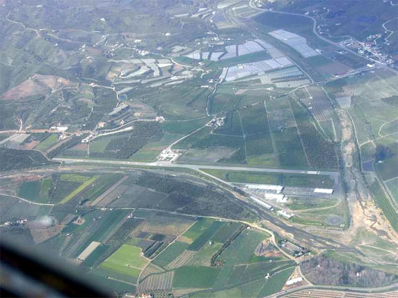
The descent into La Axarquia was rather spectacular! After changing over from Malaga Approach to the airfield frequency, one has to descend from the terrain clearance level of some 8000ft to nearly sea level, in a few miles. I did a long descending orbit around the GPS location and eventually spotted it when about 3000ft above it. An alternative would have been to descend over the sea. There was some activity there; banner towing aircraft and motor gliders, and there was no response to my radio calls. I made blind calls at the usual points but it was a free-for-all - not at all unlike some UK airfields!! After a couple of go-arounds to avoid traffic that was flying tiny circuits I landed and parked on a piece of tarmac. I had made a phone call to the airfield before the trip to establish the procedure.
The circuit, at 1000ft agl appears worryingly close to some of the villas but is actually fine.
I don't have any pictures of the airfield but found the one below on the net:
Frigiliana is a lovely little town:
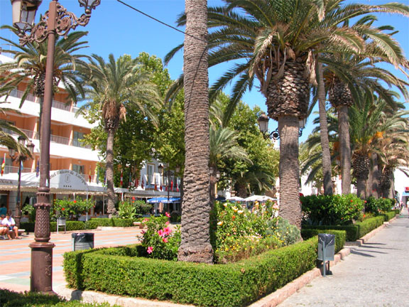
It gets very lively in the evenings when the locals all come out, taking small children out too as if often seen in Spain and France but never in the UK. There are no crowds of tourists in evidence although there is a sizeable expat community living in some very nice villas. Property prices are astonishing - as high as anything in the UK except central London. At the time of my visit, 3-bedroom houses under construction were available for Euro 220k and when finished a year later they sold for Euro 600k.
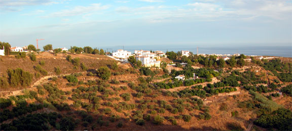
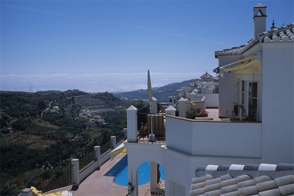
With a deposit of just 10%, I could have easily made enough to buy a complete new TB20... At the time of writing (Feb 2005) things have slowed down a bit, no doubt because property in the UK has ground to a halt, but most of the area is now well outside what most Brits can afford. Anyone who got there before 2003 has done very well and will be living in a much nicer area than the Murcia region which is being heavily developed for the beer-guzzling "British fish and chips" community :) However anyone considering living in Frigiliana would be well advised to buy a few miles away from the beach; these 3-bedroom villas are going for a cool Euro 700k (Feb 2005); as anywhere, you pay for the location:
I was staying in Frigiliana with my UK ex neighbour who had moved there a year previously. The following day I took one of them for a local flight but this was cut short when during taxi a wing hit a fence post concealed in tall grass next to the runway. It was at a very low speed while turning and the post was flimsy but it still broke the plastic front of the forward facing landing light cluster. After a phone call to a UK aircraft engineer to assess the best way to proceed, a trip to the local supermarket and a large quantity of duct tape fixed it (and the flight was cancelled), but it was a lesson learnt. As if I had needed a lesson, having had a prop strike in the UK, taxiing into a 6" deep pothole a year previously. UK airfields might have potholes but they don't usually have hidden obstacles like this. One has to be exceedingly careful. The locals obviously knew about this...
In Spain, one has to file an ICAO flight plan for every flight outside Class G. At small airfields like LEAX there may not be anyone present but there should be a fax machine. LEAX had one which was fixed up to send a fax to Malaga ATC; a receipt would be faxed back and the pilot would collect and retain this.
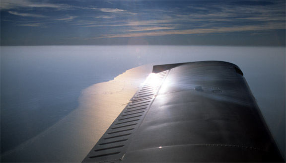
For the return to the UK, I had to get fuel, so I got some attention. A lady member of staff, an instructor I think, turned up and actually looked at my passport! The fuel pump had been broken for the preceeding few days but they had just fixed it, so I filled right up, filed the flight plan and departed. The return route was along the southern coast to just before Alicante (avoiding the Class A TMA around there) and then rejoining the original track to PAP. As often happens down there, thick sea fog came in and partially obscured the coast, creating a spectacular view:
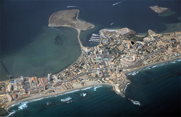
The pic below was taken somewhere around Murcia/San Javier (LELC) from about 8000ft and shows a rather well developed resort which might be best avoided :)
I managed to do a movie of the entire south coast from La Axarquia to just before Alicante - using the autopilot of course :)
After this detour, the return route was identical to the outbound route to Biarritz for another refuel. There were again some clouds south of the Pyrenees; this time with a lot more turbulence and I got ample opportunity to compare the stormscope images with massive CB columns in the vicinity. It may be worth a detour over the sea, to the west of the mountains.
For another time, it's also worth considering refuelling in San Sebastian - just a few miles from Biarritz but in Spain. There is some aviation folklore which claims that if a pilot turns up at San Sebastian dressed like a commercial pilot then he can get fuel at a substantial discount!! In fact, as I discovered on a later stop there, you get tax free fuel if you flash an Air BP fuel card with a Limited Company name on it!
For the return flight across France, due to the weekday activity in R31A1, I took the slightly inland route
LFBZ BE NB RY ANG CAN NEVIL EGKA (where the leg NB-RY must be flown at 3300ft QNH minimum due to the Les Blayais TRA)
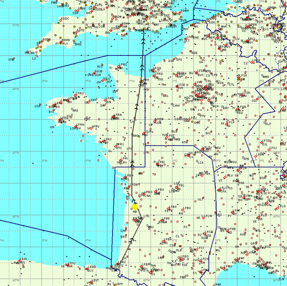
The Les Blayais power station TRA is shown as the yellow dot. Accurate navigation using a combination of GPS and ground-based navaids is a must. The UK PPL-style "proper airmanship" navigation with a stopwatch and a compass is a great way to eventually get into trouble and, rest assured, the French DGAC will pursue infringements with the UK CAA who will then contact the registered aircraft owner with a demand to trace the pilot at the time of the incident. I do recall that that power station TRA did not appear in the notams (the narrow route briefing) obtained from www.ais.org.uk before the trip; this appalling shortcoming has since been fixed.
The return flight was uneventful, with a lot of haze after leaving the French coast at FL065:
Each of the four legs took about 3:30 and presumably accurate fuel measurements from pumps showed that the flight from Shoreham to La Axarquia (or back) could have been done nonstop, with 45 minutes reserve fuel at destination! With this kind of range at 140kt-150kt TAS, and the ability to easily reach 15000ft or more if needed, the TB20 has little competition. However to be fair I was at least 10% under MTOW.
The summer of 2003 was fantastic for trips like this.
I now carry a lightweight reflective cockpit cover which greatly reduces the cockpit temperature rise when parking in hot places, and keeps prying eyes away.
The one lesson learnt is regarding filing of ICAO flight plans. One can file a flight plan anywhere in the world, for a flight anywhere else. They get distributed on a worldwide system called the AFTN. For this trip, I had filed the VFR flight plans for all four legs in advance, with the ATC at Shoreham. I used the DOF code to specify the dates of each flight. However, all except the first flight plan turned out to have vanished when needed...
Recently, I have discovered that there is no automated means of handling VFR flight plans which are not immediate. The "system" is that the ATCO clips the piece of paper on a clip somewhere, and occasionally forgets to go through the pile to see if any of them are coming up. Also, one ATCO told me that the DOF keyword is not a legitimate ICAO feature and a flight plan containing it can be ignored. So... one must file each flight plan on the day of the flight. This raises obvious issues with how to do this; a mobile fax facility may be very useful. The one flight plan which isn't likely to get lost (but occasionally still does) is one which is filed directly with the tower at the airport of departure. Now, I have a mobile internet and fax facility (a laptop with GPRS) which is absolutely great, and use the Austrocontrol service for flight plan filing.
Last updated 29th March 2006.
Any feedback, reports of dead links, corrections or suggestions much appreciated:
Contact details
