
Trip to Valencia - October 2009
This article describes a very straightforward IFR (airways) trip from Shoreham (EGKA) in the UK to Valencia (LEVC) in Spain, and back the following day.
Procedurally, the flight was very similar to other airways flights I have done. Other VFR and IFR trip reports can be found here. IFR flying tends to follow a set pattern, with the main variables being the weather and, to a lesser extent, ATC.
I have written up this trip because it makes a good example of a quick and easy IFR trip in Europe - around 4-5 hours each way - which is ideal for the capabilities of the TB20 or most other IFR touring types. The distance (710-760nm depending on airway routings) would be regarded by many as the upper limit of what is conveniently done in a light piston aircraft, due to the time spent enroute. The TB20 has a zero-fuel range of about 1300nm and I have done flights around the 900nm figure but they are rather long...
Of course, one can break up trips into shorter sections but that introduces new variables: the weather can change and one can get stuck somewhere, each section probably requires a flight plan but one cannot confidently file them all in advance because one can't tell whether there will be a refuelling delay, etc. I therefore either fly nonstop all the way to the final destination, or plan each intermediate stop to be at least an overnight stop and at an interesting location.
Here is a glossary for non-aviation readers.
Aircraft
The aircraft is a 2002 Socata TB20GT which has a zero-fuel "book" range of approximately 1100nm and an economical cruise speed of 155kt TAS at 10,000ft. Extra economical cruise power settings can extend the zero-fuel range to 1300nm. It has a ceiling of about 20,000ft and is equipped with oxygen. It is not certified for flight into icing conditions but has a TKS de-iced propeller.
Navigation equipment includes a KLN94 IFR/BRNAV GPS and a KMD550 MFD and these are used for primary navigation. IFR flight in Europe above FL095 (generally) requires BRNAV certification which in the GA context is met only with a BRNAV approved IFR GPS installation. The most common means of BRNAV compliance is one of the Garmin 430/530 products but many other panel mounted GPSs have been approved. BRNAV can also be met with the old KNS80 (with an antenna filter to meet FM Immunity regs) but this product will not alone function in today's "everything is RNAV" environment where one is routinely sent to a VOR which is a great distance away.
The aircraft has a KFC225 autopilot which can track VOR/GPS/LOC/ILS and fly a preset altitude or a preset VS. There is an additional battery powered Garmin 496 GPS which also provides an audio terrain warning (TAWS) function with a European terrain and obstacle database. A WX500 stormscope is also installed. One of the radios has 8.33kHz channel spacing to legalise flight at 20,000ft although I have never been assigned such a frequency.

Flight Planning Equipment
In this case, being a very short trip, all planning and flight plan filing was done at home, before departure, on my PC. I carried a laptop (but not the printer) just in case. Nowadays it is easy to get TAFs and METARs on any modern mobile phone capable of WWW access, but a laptop is still very handy for anything more complicated.
My laptop has GPRS/3G internet access, which provides independence from airport weather briefing and flight plan filing services which at best are an unpredictable waste of time and are missing altogether at many airports.
On a short-duration trip like this, it makes sense to file even the return flight plan in advance, because cancelling or delaying it is much easier than filing it.
Weather
My weather planning starts with a quick look at the MSLP charts for a few days around the planned trip
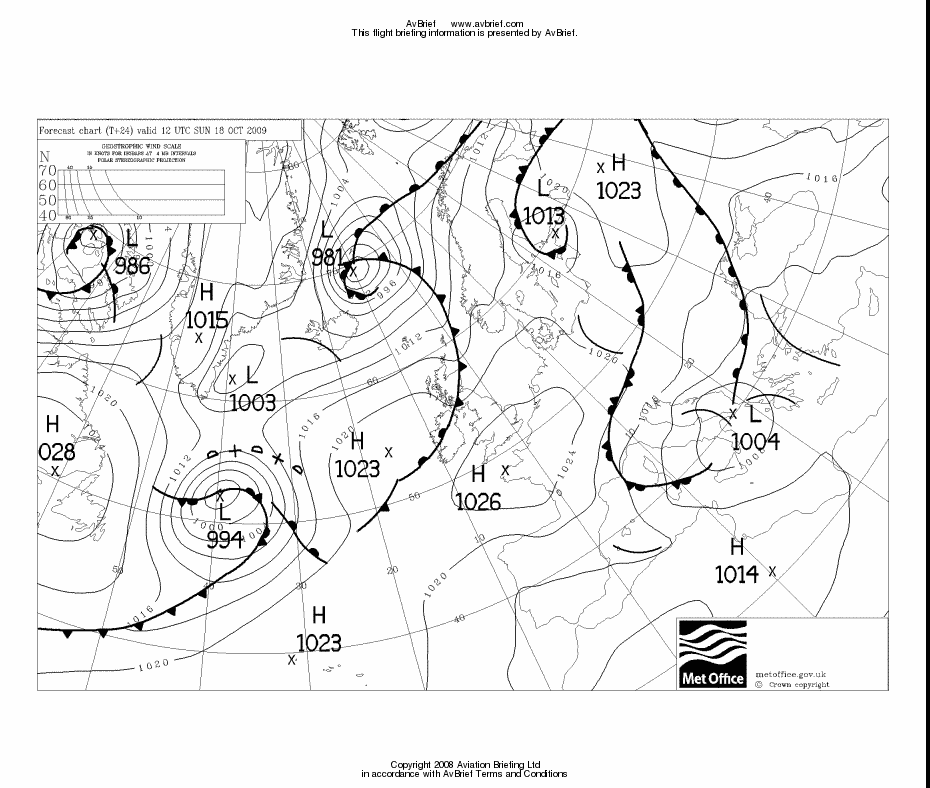
These are available up to 5 days ahead and show not only "obvious" features like fronts but also the wind direction and likely speed. A professional forecaster can tell much more... On these charts, hazardous flight conditions (generally, fronts and troughs) are clear and it is at this stage that I do most of my cancellations or reschedules. With cold fronts, and to a lesser degree with warm fronts, the following day usually presents a much improved picture.
If the MSLP chart looks good, or if it doesn't look good but the departure date is not flexible, the next step is to examine the situation for the chosen day more closely, by looking at other weather sources. Due to the limited information released freely by the UK Met Office, any further long-range data is from the U.S. GFS model which is fortunately accessible via many websites.
Airways flight in Europe has to be done at certain minimum altitudes (the airway MEAs) and the lowest available levels (say FL070-FL100) will often place the aircraft squarely into cloud. Therefore, given a non-deiced aircraft without radar, my conservative IFR strategy is to climb until VMC on top is reached and stay there (usually in sunshine) for the entire enroute section. Anything else can result in an unpleasant and potentially turbulent flight with - especially over hours - a significant chance of icing. Another risk in flying great distances in IMC is that one obviously cannot see ahead and a serious deterioation in the conditions cannot be detected until it gets bad enough to show up on a stormscope or on radar - or one is banging one's head on the ceiling...
Ideally, one needs an accurate cloud tops (vertical humidity profile) forecast but the quality of such forecasting remains poor and one is doing well if the forecast is within a few thousand feet of reality! Some notes on cloud top data are here and a more general tutorial for IFR weather planning is here.
The day before the planned departure, the SigWx form (available about 18 hours ahead) shows hazardous weather above FL100. Contrary to popular belief, it does not depict cloud tops!
The data from the above sources can be verified against TAFs/METARs for departure, destination, alternate, and perhaps some airports along the route. This is important; even though a TAF is a surface forecast and is necessary anyway if one is planning to land there, it should contain vital clues to high altitude hazards. For example, a forecast of +TSRA is going to mean CBs and if the other data suggests IMC above the aircraft operating ceiling then the CBs will be embedded... a clear no-go scenario for me.
If ambiguities remain, some really good stuff can be looked at shortly before the flight: weather radar, sferics and satellite images. These represent real data, not forecasts which could be wrong. Recently I have started using IR satellite images and I have included them in this writeup as I now think these have probably more value than most of the other stuff!
My general approach is to pick a departure date that is convenient for personal reasons, and GO unless there is clear evidence that the weather will be hazardous. Forecasts are usually pessimistic (PROB30 is code for "I don't think it will happen but have to cover my backside"; PROB40 is code for "it might happen", and other probability figures are not permitted by ICAO) so unless passengers with complicated arrangements are involved, a flight should never be cancelled except on the morning of departure.
For this trip I unashamedly picked an unseasonal patch of good weather - to see the scenery and get good photos.
The MSLP charts for Sunday Monday Tuesday showed a nice high pressure area on the first two and bad weather moving in after that at the UK end. I cancel quite a lot of trips due to return weather issues because the instrument approaches at Shoreham have a high MDH (in prevailing winds, runway 20, 800ft) and thus poor utility for getting back home.
The Sunday MSLP showed a small trough near Valencia, but this was not reflected in the TAF...
The MSLP charts also indicated light winds. Moreover, the Sunday one shows a likely tailwind going south, and the Monday one shows a likely tailwind going north. It is very rare to get a tailwind on both legs!
As for SigWx, the 0600 1200 showed nothing significant.
I don't attach a lot of weight to the SigWx form in isolation because it depicts only "hazardous weather". It appears to show cloud tops - for example Area 8 in this one suggests the tops there are FL140 - but this interpretation is incorrect. You could have a clean SigWx form and could spend the whole flight in IMC. Opinions differ on whether there could be icing if nothing is forecast but clearly there is always a possibility of this in IMC below 0C, and anyway the forecast could be wrong. I use the SigWx as a no-go indicator; if, together with some other data, it shows bad weather to a high altitude then I scrap the flight. However, the SigWx is widely used by high-end IFR pilots and is undoubtedly OK to rely on by de-iced aircraft, preferably radar equipped.
The IR satellite image on the morning of the flight showed no high altitude cloud. On these images, the whiter the cloud is the lower its temperature and thus the greater its altitude. High altitude cloud, say FL200 plus, shows up as something approaching solid white. IR imagery which contains a temperature scale (enabling a more accurate altitude estimate; if necessary by reference to altitude/temperature data which for some reason is a lot more accurate) is available but I have not found any which is free and less than several hours old...
Finally, on the morning of the flight I got the TAFs and METARs which showed nothing significant.
Some of the above weather data is from Avbrief (which I like to use because it has most things in one place) but all the weather data above can be found on the internet for free!
Preflight Procedures
IFR route design: The Eurocontrol (often interchangeably called CFMU or IFPS) IFR routings were generated and validated online in just minutes using FlightPlanPro (FPP). This routing tool has revolutionalised European IFR route development. It generates an initial route from its internal airway database; the route is submitted to Eurocontrol for validation (internet access is required) and is iteratively modified.
My normal "workflow" in IFR route planning is:
1) Generate the route in FPP. This also shows the total distance which is a vital feasibility indicator:
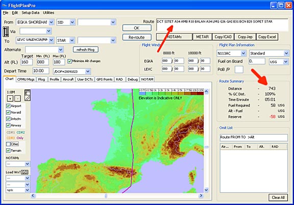
For the "target" level I use FL140 to FL160. Lower levels often generate less optimal routings, but generally most routes can be flown as filed on the day by asking for a lower cruise level if the weather is found to be good - down to about FL100 or even lower.
Above FL160, I have never seen an improvement until FL200 (the upper airways) but I won't file FL200 because I might have to actually fly it... and the TB20 is about 10% less efficient (MPG) at FL200 than at FL160, due to the need for max rpm.
2) From FPP, copy/paste the route into FliteStar's Plain Language entry box (found under the Routepack Wizard)
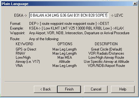
and click on Finish. The route pasted into the above box must be first stripped of any airport names and SID/STAR identifiers. Some more highly optimised routes from FPP also include speed/level specifications and these must be stripped out too; this whole exercise is lateral planning only.
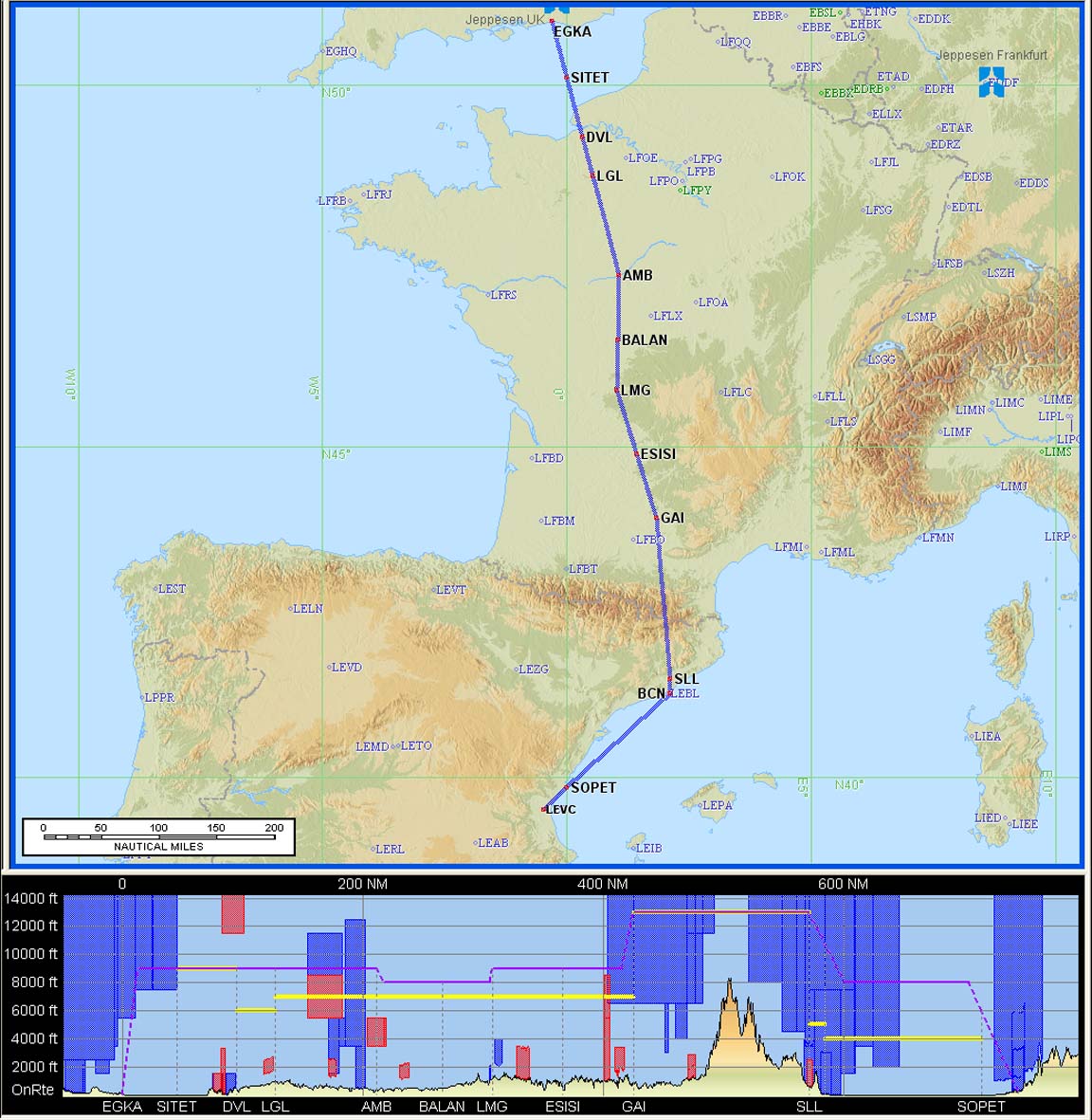
3) From FliteStar, print off a "routepack" containing the following
- the overall route picture (as those shown below)
- enroute airway chart sections (scale 1"=15nm or 1"=10nm are needed
to show intersection names - example)
- the Nav Log (called "plog" in the UK) which contains the airway
route decomposed into individual waypoints, with distances, tracks etc
- the ICAO flight plan (some airports won't let you go airside unless you are
holding one of these - even if the filing was done via the internet...)
All the above are A4 and fit well onto a kneeboard. For virtually all flights thus planned, there is no need to look at the printed airway chart at any time.
The FliteStar plog can potentially contain - depending on the style selected - a lot of information, e.g. how much fuel one should have at each waypoint, but I don't use any of this because the default Socata TB20 aircraft model in FliteStar is grossly pessimistic for anyone operating their aircraft at economical cruise (LOP) power settings. I have tried to edit the values in the model but FliteStar then crashes, claiming the aircraft model is invalid, so I have given up on this and just use FliteStar as a "printed route pack generator" which it does excellently. Also, vertical planning is done entirely outside the program; the level filed is according to what routes can be generated with FPP, and the level actually flown is decided almost entirely tactically when airborne. The fuel efficiency (MPG) of a normally aspirated aircraft is largely independent of altitude, once above about FL100, provided one remains LOP and not close to the operating ceiling.
4) File the ICAO flight plan, using one of the electronic services. That's it!
I have mentioned FliteStar repeatedly. It is currently the only program capable of accepting an airway route, plotting it so it can be printed as good quality A4 enroute chart sections showing airways, intersections, etc, and generating a plog from it - all in one go. But FliteStar IFR Europe costs about £500 for the first year (subsequent cost depends on the desired update frequency) and it isn't the only way to do this. A pilot willing to fly with the unwieldy printed airway chart can get the waypoints from that... The plog can be printed from FPP. The email confirmation from EuroFPL contains a waypoint list generated from the filed route by Eurocontrol itself, and one could pick up that email with an email capable mobile phone and load the GPS with it (which would be really slick - except that some waypoints are prefixed by the Eurocontrol system with a * and then truncated to 5 characters, so the last letter of a 5-character waypoint gets lost)... At a real push, one could manually (laboriously) draw the airway route in Navbox and generate enroute chart sections and a plog from that (I had to do that once, a few years ago, when a particular route Prague-Shoreham crashed FliteStar every time)... The notams can be obtained from FPP, EuroFPL, Homebriefing, Avbrief, and countless other places. So, there are numerous ways of generating the flight data, and some are very basic especially if one is willing to depart with minimal information. Recently, EuroFPL has significantly expanded the options. And if one has a GPS which can accept airway designators directly (the discontinued Garmin 480, or new versions of the G1000, or some others) then there is even less work to do.
I never use the IFPS REROUTE ACCEPTED option in flight plans because it doesn't fit in with the way I do flight planning, which is to do as much as possible before leaving for the airport. If this option is used, a number of issues can arise:
When Eurocontrol amend a route, they communicate the amended route to the flight plan filing agency, which obviously needs to somehow communicate the amended route to the pilot. This is not going to happen unless the pilot is "around" - still hanging around the airport briefing office, etc. If he has filed the flight plan electronically (Homebriefing, EuroFPL or AFPEx) these return the amended route to him by email/SMS etc. The alternative is to depart without knowing the route loaded into the ATC system, hoping to get it spoon-fed by ATC during the flight; this will work most of the time. Except in the "lost comms" scenario where one is supposed to - in essence - fly the filed route all the way to destination. And "lost comms" isn't just a total radio failure; it is much more likely to happen due to flying out of the current frequency's range, or in some places due to ATC "forgetting" the route.
Once one has received the amended route, there is no convenient way to decompose it, with its airway designators, into a "plog" comprising all the individual waypoints to be loaded into the GPS, unless one traces it out on a printed airway chart, or starts up a laptop running Flitestar or Jeppview - neither of these options are the kind of thing one wants to be doing when heading for the airport.
The ability to print out enroute chart sections from FliteStar is highly valuable in organising the cockpit - the printed airway chart is awkward when airborne - but this works well only if one does not allow one's route to be grossly modified.
In extreme cases, the amended route can be sufficiently longer to impact one's fuel planning. In any case, having received the amended route on one's phone (email or SMS) it is not obvious how much it was amended until one gets the airway chart out, or plots it in FliteStar, etc.
Finally, Eurocontrol do not always perform the re-route; my limited experience of trying it suggests that if the issue is complex they will refuse to touch it, and obviously the flight plan filing agency will do the same (not their responsibility) - leaving the pilot to pick up the pieces at the least convenient time and place.
In view of the foregoing, it is better to get into the habit of using an IFR routing tool like FPP to generate all required validated routings before leaving one's home. However, routings can change after a few days, which is why a laptop with internet access is required for longer trips.
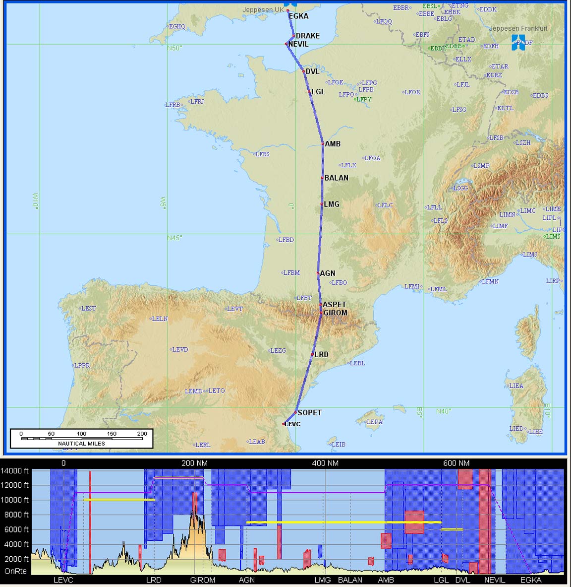
The outbound route:
EGKA
SITET A34 AMB R10 BALAN A34 LMG G36 GAI B31 BCN B28 SOPET
LEVC
FL140
680nm (GC) 745 (airways)
Alternate: Alicante LEAL
This route was generated instantly with FPP.
It would have been nice to get rid of the ~ 50nm waste at the end (and make it more like the return route - further below) but there are no airways available that point in the right direction. I could have done some hacks but in fact seeing a bit of the coast was desirable, so the routing was left as generated. I chose FL140 because it lies above most routing restrictions, and one can always ask for a "stop climb" when a lower level is fine due to good weather, etc.
The TB20 could fly nonstop to Malaga LEMG, with IFR reserves.
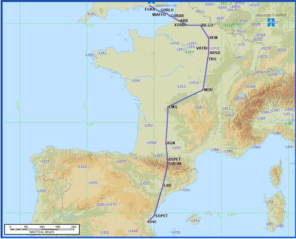
The return route turned up a slight problem. FPP failed with
ERROR PROF204: RS: TRAFFIC VIA EGTT18SFD:F075..F245 IS ON FORBIDDEN ROUTE REF:[EG2018A] NEVIL G27 LYD
This type of error occurs because most of the airways from France to the UK point in the wrong direction: south! This issue is well known to pilots and in fact was fixed in the next version of FPP. The usual solution is a hack made up of some DCT legs. These needs to be kept below 50nm each (above FL100) or 100nm each (below FL100). Replacing NEVIL G27 WAFFU with NEVIL DCT DRAKE DCT yielded this IFPS-validated route
LEVC
SOPET N609 GIROM A29 AGN A34 BALAN R10 AMB A34 DVL DCT NEVIL DCT DRAKE
EGKA
FL140
680nm (GC) 713nm (airways)
Alternates: Bournemouth EGHH, Lydd EGMD
on which the kink at NEVIL will never be flown anyway because one will get a shortcut from ATC along the lines of DVL-DRAKE, and UK ATC (London Control) will offer a "DCT Shoreham" in a descent out of controlled airspace.
In fact, anything that avoids routing via SITET is OK. Other hacks which actually route via SITET work by not mentioning its name e.g. NEVIL DCT SFD190040 DCT where SFD19040 is the same place as SITET. These "more dirty" tricks are rarely needed but are worth knowing, for cases where one can be sure that there is definitely no military or other restricted airspace; their best application is where there are airways in place but going in the wrong direction, or for solving intractable routings near the departure or destination airfields.
One can manually edit the FPP-generated route as follows: in the top RH window which shows the route generated so far, edit as required. Select the "CFMU Msgs" tab (2nd from left) and use the Validate button (which will be marked as either "AvBrief" or "EuroFPL" depending on the validation service you have selected in the preferences). The user-edited route will now be validated using CFMU and will be used for the plog, notam brief and the displayed chart. It's a rather less than obvious but extremely useful feature.
The "totally proper" airways route, as generated by the new "suggested route" facility provided by IFPS (accessible via FPP, and more comprehensively via a new facility provided by Avbrief ) was a ridiculous detour around France
with a 100nm overhead... This illustrates the huge disparity between the airway system design (who exactly does that job???) and the routes which ATC actually operate. Admittedly, the above "silly route" was generated at a single flight level, but there is no tool currently available which can mix totally-on-airway routings with multiple levels; unsuprising really since the result would still be poor once one gets above about FL100. DCTs are the only way to get reasonable routes, and FPP does a very good job of it.
Notams can be obtained from many sources. With IFR flights, enroute situations (e.g. restricted areas due to military activity or airshows) are not normally an issue because the entire flight is under radar control and Eurocontrol and ATC will make sure no traffic is routed where it should not go, but notams remain vital for airport information such as out of service instrument approaches and PPR requirements. They are also vital for VFR portions of an IFR flight, or any portion where one transits uncontrolled airspace (in and out of Shoreham, in this case) - with or without a radar service. Sometimes, PPR requirements are notamed. I tend to use the traditional UK NATS website; I use the Narrow Route Briefing only and simply paste the IFR route in there. Sometimes, I use the Avbrief "airport notams" feature. However, on this trip I used the EuroFPL "Brief" function (example, 1MB PDF) to generate a weather overview with airport notams.
PPR (prior permission required) was not an issue in this case. Valencia has mandatory handling, so one may as well contact the handling agent which for GA is Servisair 0034 961 598689 and they turned out to be very efficient and friendly, with fast email replies too. And for 87 euros, that's to be expected! For contact details of handling agents, the best source is the ACUKWIK airport directory.
Flight plan filing was done electronically, using EuroFPL. Recently I had been using the AFPEx AFTN messaging tool for flight plans, but decided to give EuroFPL a test. They proved to be excellent, and their flight tracking facility is awesome. More notes on electronic flight plan filing options are here.
Note: the Eurocontrol routings given here and elsewhere will most likely not work by the time you might try them because the precise form needed to get the route into the Eurocontrol (IFPS) computer in Brussels changes from one week to the next, and there are frequent differences between weekdays and weekends which are largely due to a lack of military activity on weekends.
Beware: the terrain profiles shown in the route illustrations above is not accurate. The Jeppesen Flitestar software contains large elevation errors. Also, the flight level shown in the profile diagram does not relate to the flight; filed or actual. I am not sure how FliteStar determines the various levels which it plots on the terrain profile; it's probably in the manual somewhere...
Fuel Planning
Given the expected light winds, fuel was not an issue on this flight, involving around 50-60% of the aircraft zero-fuel range. Spain has plenty of airports with avgas, too.
Time Spent on the Above?
The various parts are done over a day or two so it's hard to estimate, but it takes around 2 hours, divided up roughly as follows:
Route development - 10 mins
Flight plan filing - 10 mins
Notams - 10 mins
PPR - 10 mins
Weather - 10 mins
Printing out routepacks, etc - 1hr
Obviously one can do it much faster if in a hurry, or using route familiarity. PPR in particular can take anything from zero to "days" to sort out. Flight plan filing is nowadays as quick as one can fill in the online flight plan form.
The Flight
The Shoreham (Class G) departure clearance was: "remain outside controlled airspace, on track BOGNA, squawk 2214, contact London Control on 133.175".
The initial base of controlled airspace is FL055 so one sets FL054 as the target level on the autopilot...
On first contact, London Control asked for the customary squawk ident and then issued a clearance to enter controlled airspace, on track DRAKE, climb FL100. Shortly afterwards they asked what cruising level I desired; I chose FL120 as we were climbing well above the cloud and there was a nice tailwind

We could have gone higher; say FL160 to pick up a few extra kt of tailwind, but (see note near the end) one of the oxygen demand regulators was found to have jammed (fortunately, in the open position) and as this was going to increase the oxygen usage, I did not want to climb unnecessarily.
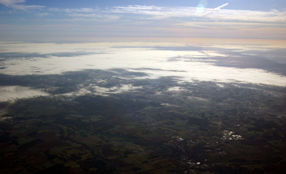
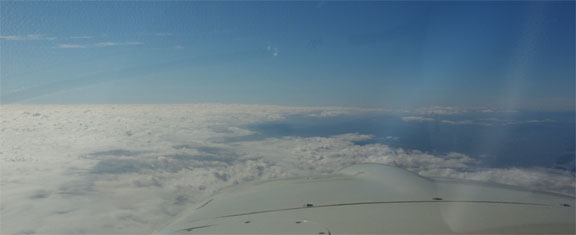
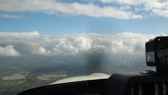
Soon afterwards the layer became overcast
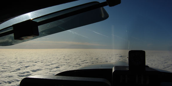
About 100nm into France the clouds thinned out
The Landing Fuel on Board (LFOB) figure, recomputed by the fuel totaliser every 1 second, stabilised around 39 USG
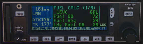
and stayed there as the tailwind remained around 30-35kt.
Eventually, the terrain of southern France became more apparent
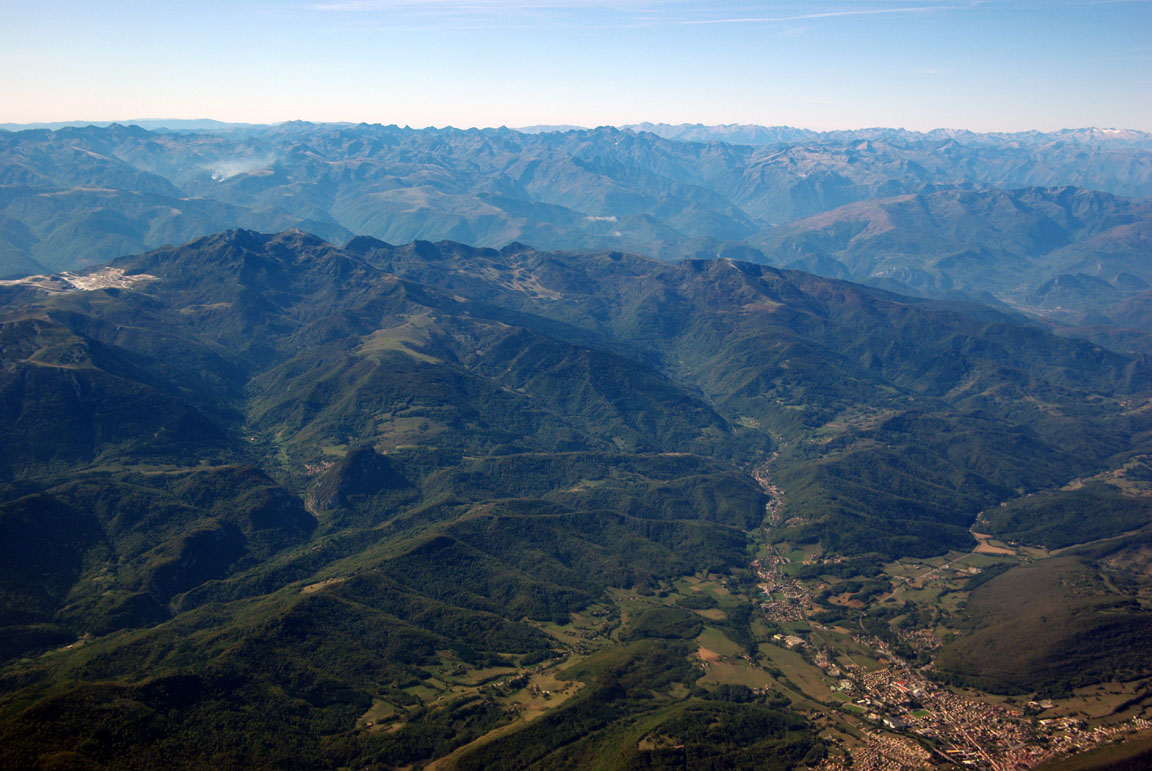
Due to the 30-35kt wind flowing perpendicularly to the mountains, and our projected height above the Pyrenees of about 5000ft, I expected some turbulence so we climbed to FL140, but none was encountered.
At FL140, flying on a reasonably economical cruise power setting, we were achieving 140kt TAS on 9.5USG/hr (peak EGT) at 2400rpm
One can achieve a higher speed (around 155-160kt TAS; FL120-140) at max rpm (2575) and 100F ROP, or a better economy at low RPM (2200) and LOP.
Some impressive DCTs were given by ATC; 166nm, 173nm, 164nm. This really demonstrates that European IFR flight is a purely RNAV point to point GPS navigation procedure, and real physical VORs mean nothing... so long as the GPS keeps working! The yoke-mounted Garmin 496 would provide a perfectly usable DCT-mode backup in the case of the KLN94 failure.
The best shortcut, from Spanish ATC, was "DCT Valencia" of 260nm but after a few minutes they decided they made a mistake and asked me to follow a specific airway instead. Unfortunately, the enroute chart section (printed from FliteStar) did not show the airway name on any page which contained it... luckily we had a Jepp airway chart to hand and started unfolding it all over the cockpit but in the meantime I asked ATC for some waypoints. By the time they came back (a few minutes later) we found the airway anyway and picked up some waypoints from that. Just as well this was in VMC; I was not convinced that they were overly particular about their minimum vectoring altitude...
The Pyrenees were crossed at their eastern end

I normally try to find out early (from ATC; 50-100nm before arrival) what runway is active so I can get the approach plates sorted into probable order, read the immediate ones in detail and set up the avionics in plenty of time. In this case, however, I was given the STAR, as SOPET1D, with 230nm to run, and this also revealed the runway in use (12). This was followed shortly by a DCT SOPET (164nm). The STAR contains a DME arc which I cannot fly with my GPS so I set up to fly it conventionally. However, very soon I was given a DCT OPERA which obviously eliminated the DME arc and indicated either a radar vectored ILS or some kind of "halfway procedural Spanish see what happens" thing...
The STAR (standard arrival route) is supposed to match the terminating point of the filed route (SOPET in this case) and if it does not, this must be queried. Also, you have to be ready to fly it, even though flying in its entirety it is rare in the European radar control environment where radar equipped approach controllers use radar almost exclusively for tactical traffic management. SIDs (standard departures), on the other hand, are nearly always assigned and flown as published - even if generally not all the way to their terminating waypoint. A pure "radar departure" is rare.
There was some cloud cover when approaching the destination
Following a more or less continuous descent from FL140 to 5000ft over about 60nm, the assigned approach was "if ground contact, intercept the ILS at 6 miles" which was OK by then as we were visual. There was some ambiguity whether we were cleared to descend to the 3000ft ILS platform altitude (which is either explicit, or implicit in the specific phrase "cleared for the ... approach") and by the time I managed to clear this up, the ILS was intercepted marginally above the glideslope.
Suprisingly, it was raining quite heavily all over the airport area - something not appearing in the ATIS... that "little trough" seen on the MSLP chart had clearly arrived!
We parked with 36.7USG. The fill was 186.5 litres which (full tank 86.2USG) differs from the computed fill by just 0.33%, with the error on the safe side. This is among the best I have seen. The Shadin fuel totaliser is a great system to have on long flights, but the original factory installation was plagued with defects which took me years to identify and fix, and I think most aircraft owners would have just given up on it. I always fill right up at the pumps, and check the accuracy on every fill.
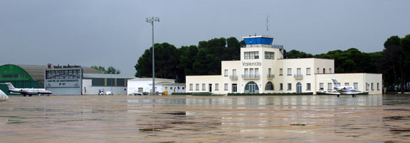
After landing at Valencia, you first taxi to the pumps which are north of the runway (where a policeman turns up and inspects passports etc) and then you taxi a very long distance to the GA apron which is south of the runway, where the handling agent bus picks you up and drives you all the way back to the GA terminal which is north of the runway (a short walk from the main passenger terminal). I had been warned about this bizzare scheme by a Spanish pilot friend, but forgot, reached the parking spot, and had to taxi all the way to the pumps and all the way back again... Of course one could taxi to the pumps at departure time, but Rule #1 in GA is to always fill up after landing because of unpredictable fuel delays.
One taxies past what looks like the original terminal building
Unusually for my 2009 trips, I was able to use my AIR BP card, though any credit card would have been OK too.
Avoiding handling charges: "Request taxi to the aeroclub" works in most places where there is an aeroclub, but obviously one needs to make contact with the aeroclub first to make sure it is OK with them, and in the past I have found that they rarely have anyone speaking English. There is also no obvious way to dig out their phone number... A local pilot friend is the best thing in this case.
The taxi to the town centre was Euro 20. We stayed at the Vincci Palace hotel which was excellent.
The outbound flight was tracked using the EuroFPL aircraft tracking facility which accesses a feature provided by Eurocontrol. The following flight progress snapshots
can be viewed on a special EuroFPL website whose URL is emailed to the subscriber who filed the flight plan, immediately the flight plan is accepted. The URL (the EuroFPL Tracking code) is valid from filed EOBT -0600 to +1800. The track data is available upon aircraft departure and the whole track is visible for some hours afterwards. Justine captured these snapshots back home, during the flight. This can be an invaluable feature if one is meeting somebody...
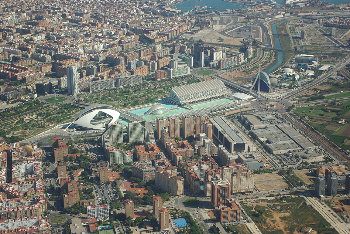
Valencia
Valencia has a lot of old Spanish architecture. However, perhaps its most notable feature is its futuristic science centre and exhibition complex

(some images supplied by my passenger Steve Doidge, with many thanks)
Return Flight
The 0600 and 1200 and 1800 SigWx showed nothing of significance. The TAFs and METARs were fine also. The sferics and radar images were clear.
The IR satellite image showed some dispersed high altitude cloud but as the other information was clear, this was probably very thin cloud which would not be an issue. In any case, it was all north of the Pyrenees and a descent below the 0C level (around FL100) would always be an option to avoid icing. I would never choose to fly this kind of distance (in an aircraft without all-over de-icing) in IMC and above the freezing level.
The formalities at Servisair took about half an hour. The landing fee was 14 euros and the handling was 87 euros. 1 night's parking was included in there somewhere... It was efficient but too expensive to make flying to Valencia a regular outing. However, there are a lot of GA aircraft parked there, plus an aeroclub and pretty obviously they are not paying these prices
As with most large airports, one collects the departure clearance from the Ground or Delivery frequency. The initial waypoint of the filed return route was SOPET and for the active departure runway 12 this suggested the SOPET1B SID (standard instrument departure). This comprises of just the two waypoints PND and SOPET and is flown simply by loading PND into the GPS flight plan (as well as setting the ADF to 340kHz of course, etc ...). The departure clearance was "cleared to destination SOPET1B departure, 6000ft, squawk 5543". This means the whole SID is flown as a climb to 6000ft. The SID (or a STAR) is the lateral clearance; the assigned altitude or flight level is the vertical clearance, and these two are completely separate.
At practically any airport, the departure taxi route does not get a FOLLOW ME vehicle - you have to work it out yourself on the airport map! One must always ask for taxi instructions if in any way uncertain - getting lost at big airports is quite normal even for passenger jets - and the tower controller was most helpful. This picture was taken at the departure holding point
where there was a 30 minute total wait due to around 6 or 7 passenger jets and wake turbulence spacing... clearly we had picked the worst possible time for departing (1100Z) and ATC let all of them go before us - though very politely apologised for the delay. In the meantime, some of the Ryanair or Easyjet pilots were getting very unhappy about the delays, with banter like "welcome to the 3rd World of Europe" :)
The departure offers a spectacular view of the city
We got airborne 3 minutes after the last passenger jet so I was expecting significant turbulence but there wasn't really anything...
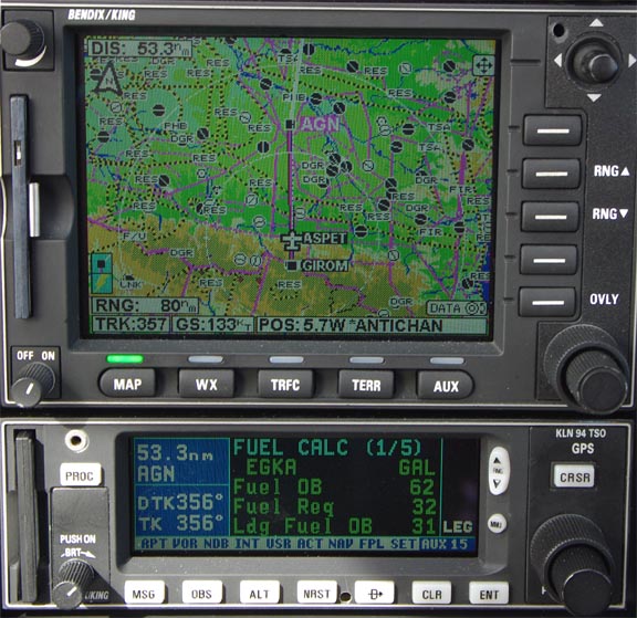
Shortly after, I got a climb FL120 and a DCT LASUN, followed by a 162nm DCT to GIROM. All very straightforward. Towards the Pyrenees, ATC stated that we have to climb to the minimum airway level of FL140. Actually the minimum level shown on the airway chart is FL130 (which is also correct according to the semi-circular rule) and I politely asked them to check this; they said they would get back but never did. Anyway, we climbed to FL140 for the mountains.
There is a large "mystery airport" close to LRD
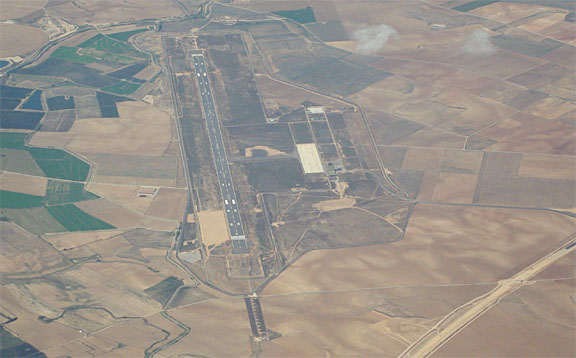
whose terminal buildings and an access road are under construction. Maybe they are banking on a recovery in the UK property market and are building a housing estate for another batch of 100,000 retired British builders? Or maybe it was started long ago and has been abandoned...
This time, the Pyrenees were crossed in the middle, and the clear weather provided spectacular scenery from about 5000ft above the peaks... it looked a LOT closer...
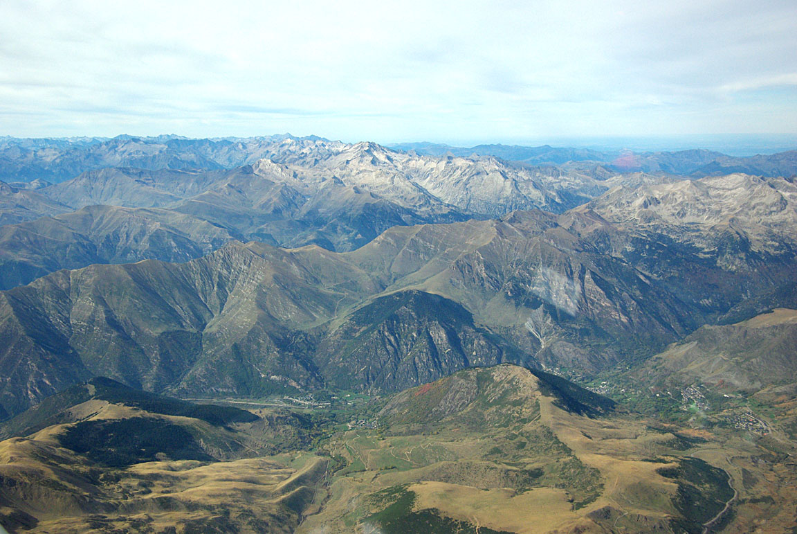
There are some striking rock formations; this huge "crater" being one of the best ones:

The GPS track is here (330k) and the Google Earth track (with the SIRF-2 GPS altitude almost corrected) is here (90k). The "crater" was eventually located on GE by getting the EXIF timestamp from the camera image and finding the corresponding GPS location. The GE bookmark for the crater itself is here. When viewed in plan view in GE, it is apparent that the feature is circular only from the camera viewpoint...
The haze makes photography difficult. One can do some enhancement in Photoshop using Adjust Curves, and manually adjusting the lower and upper edges of each of the three spectra to take out the missing parts. Unsharp Mask also helps, at the very end, but can introduce a lot of noise. Cockpit reflections are easier to avoid, by having clean scratch-free windows, by wearing dark clothes, and by holding the lens very close to the window (but not touching it as that marks the window and transmits vibration to the camera).
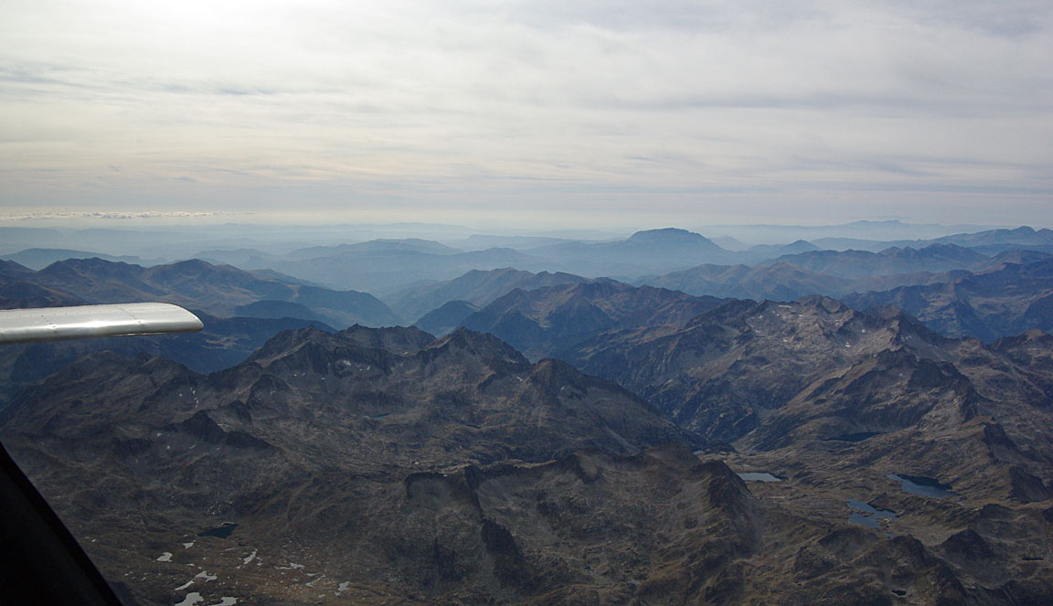
Only a little snow remained from the last winter, at around 10,000ft altitude

The Pyrenees provide far fewer forced landing opportunities than the Alps which have huge flat-bottomed canyons...
Early on, the computed LFOB figure was about 25USG but as the headwind reduced - to about 7kt, giving 133kt GS - it improved to 31USG
The return flight was flown at the most economical power setting: 2200rpm and 9.0GPH (LOP).
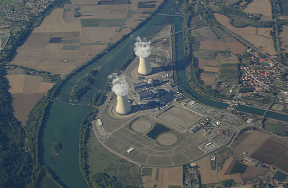
Somewhere in France we flew over one of their nuclear power stations; these have a prohibited area around them extending to around 3500ft AGL. Allegedly, the penalty for a bust is 10,000 euros and aircraft confiscation. Luckily we were at FL120 and under radar control by ATC...
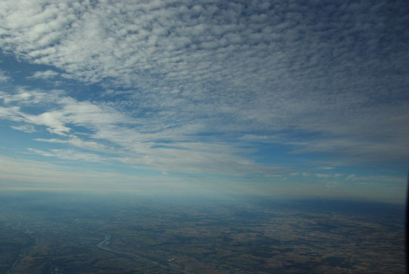
The high altitude cloud seen in the IR satellite image was this - about 25,000ft and irrelevant
Very few shortcuts were given by ATC in this leg, but it was relatively straight anyway.
In France, one can fly "IFR/airways" down to about FL070, in their extensive Class E airspace, under the excellent radar services provided by their regional FIS units. However, we remained at FL120 all the way to the UK, partly because some tailwind was being picked up and the higher the better, partly to not risk the quite efficient routing we had filed, and partly for a more obscure strategic reason: retention of the IFR clearance right up to the last moment.
In France, IFR flight below about FL120 is handled by the regional FIS units, not by the enroute IFR controllers such as Paris Control. When crossing from France to the UK, off the major airways, and particularly when going into an airport which is outside controlled airspace (CAS), any level below FL120 is liable to result in a transfer to London Information on 124.60 (a non-radar FIS service incapable of issuing or managing an IFR clearance) rather than the correct London Control. I have not been able to find out the reason for this but one ATCO suggested that it may be due to ATC letters of agreement between France and UK - Paris Control hands over to London Control but e.g. Brest Information hands over to London Information. A handover to London Information amounts to a loss of the IFR clearance but this is not communicated to the pilot - even though he filed "IFR" and thus reasonably expects a continuous IFR clearance, he needs to be aware of where CAS lies and descend out of it and not climb back in. When returning to a coastal airport like Shoreham, this is not normally a safety issue because one is going to be descending anyway, but it could be a problem if one wished to remain above weather right up the very end, or if going somewhere inland, or if needing to divert somewhere inland at the last minute. Flying at FL120+ in the area where the handover to the UK takes place (N France, near the French coast), and being with Paris Control, transfers the flight decisively to London Control's "watertight compartment" and ensures an uninterrupted IFR clearance.
If one has lost the IFR clearance, one can get London Information to obtain a new IFR clearance (from London Control) but this can take time if they are busy, and may not be successful if the flight has left UK CAS for long enough for the IFR flight plan to be discarded.
Pilots wishing to retain an IFR clearance at sub-oxygen levels need to stay on routes which are on published airways and always in CAS - for example the R41 airway from ORTAC to SAM has a base of only FL035. However there are very few such routes going back to the UK.
There is a separate and more clear issue if flying from France to say Shoreham or Lydd at a level which is below the base of the UK controlled airspace which is encountered when crossing the France/UK airspace boundary (CAS base FL075). France is quite happy with an IFR flight at FL070 but one will not get any IFR clearance upon entering the UK because only London Control can do those, but London Control does not handle traffic outside CAS. The transfer will always be to London Information - with a loss of the IFR clearance.
Around the French coast we were handed over to London Control who gave us a DCT DRAKE and, with 60nm to run to Shoreham, a descent out of controlled airspace on track to Shoreham. The lack of "weather" on the remaining track was evident so this was accepted

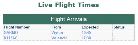
The "arrival board" on the airport website:
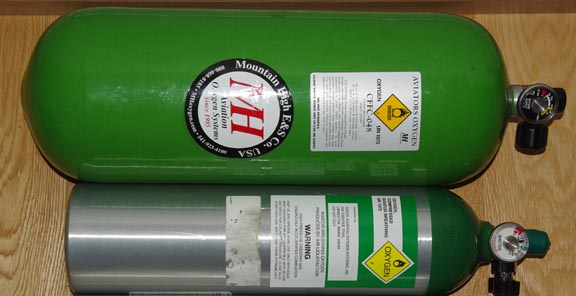
We carried these two oxygen cylinders and used up 2/3 of the big one which is a carbon/kevlar composite type; $600 from Mountain High. The small one is from Aerox and I have a couple of them
At the very start of this trip, I found that my mechanical Precise Oxygen demand regulator

had jammed; fortunately in the open position. The altitude adjustment on it still worked but the jam resulted in a roughly doubled gas usage by the person with that regulator. The other regulator (I have 2) was OK. This is quite a lesson - I know that most people are simply not functioning for very long at FL120-140 without oxygen, so flights such as this would be infeasible. More notes on oxygen systems are here. If I ever change over to the electronic Mountain High demand regulator system, I will need to buy two of their dual-output regulators because they fail shut when the batteries run out.
Most unusually, I had a tailwind on both legs of this trip. Well, nearly so. There was a consistent 30-35kt on the way down, and on the way back an initial headwind of 14kt gradually changed to a tailwind of 5kt.
The LFOB upon arrival was 31.2USG which represented an error of 0.91% against the value computed by the fuel flowmeter; this time in the "unsafe" direction but well within system tolerance.
Airborne times were:
EGKA-LEVC 4:40 hrs
LEVC-EGKA 5:10 hrs
No other aircraft were seen anywhere near my cruise level. At "GA levels", say FL100-FL200, the enroute airspace in Europe is a virtually empty void. The only GA aircraft seen were at very low levels, way below us. The only commercial aircraft seen were way above us, making contrails around FL300 plus.
This trip - using an appropriate route - would have been doable under VFR but not "exactly legally"... Some IMC flight would have been very hard to avoid. However, the total instrument time logged was only about 20 minutes; this demonstrates the value of an IR and the whole-route IFR clearance in all airspace classes which enables flight in VMC above the clouds.
Except for the confusions in Spain, all ATC were entirely professional and totally helpful.
The Avgas 100LL fuel at Valencia cost GBP 1.67/litre, including duty at about 41%, VAT at 16% and a pile of small items. The bill (via AIR BP) included a "hook up fee" of GBP 9.95 - I have seen a runway lighting charge (at Tirana, Albania) but haven't seen this one before...
The aircraft performed perfectly. A TBM700/850 would have shaved an hour or two off the door-to-door times - for an order of magnitude greater operating cost. Some notes on Socata TB20 ownership and operation are here.
Some people ask how I manage to do these long trips without using the "toilet". Well, the answer is very simple: I don't! I carry a quantity of empty juice bottles

and would never embark on even the shortest trip without them. Lady passengers need the more specialised aviation-type container (widely available from pilot shops) with an adaptor
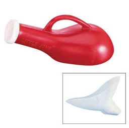
I don't use that container myself because it isn't cheap and thus needs to be carried to the home or hotel, washed out and allowed to dry, whereas the juice bottles are disposable... Most important: do not lose the screw-on cap!
Most pilots deal with this issue by dehydrating themselves before a flight but that just makes one's brain not function properly. On a long flight, a good procedure is to drink nothing in the last 2 hours or so before departure and then eat fruit e.g. strawberries throughout the flight.
These very simple procedures make it possible to fly a reasonable distance while avoiding the much greater hassle of an otherwise pointless landing, landing fees, wasted time, extra flight planning, filing extra flight plans, increased weather risk - plus PPR issues which mean that with many airports one cannot just "drop in". With children, something like this is necessary anyway.
Pilot: FAA CPL/IR, approx 1100 hours.
Any feedback, reports of dead links, corrections or suggestions much appreciated:
Contact details
This page last edited 18th November 2009
